January 29 Blizzard Passing By This Morning With Increasing Winds
Saturday January 29 – Morning Report
This complicated forecast worked out close to expectation but has not been perfect. The back edge of snow did develop and hang on near Baltimore and Annapolis overnight, but that sharp cutoff will have some farther inland with less than hopeful snow.
Heavy snow continues on Delmarva, but totals will take a while to confirm in part due to the early timeframe and wind blowing around drifts. But coastal areas shows verify close to 1 Foot!
West of The Bay many will say this was a dud or bust. There was a sharp cutoff from the steady snow that I could not have repeated any more. That dusting to 2 inch range may very well have lined up with my original call… covering more to I-95. I will have a wrap up this evening and you can grade my forecast then.
There is so much to talk about with this storm as it rages for New England, brought snow to Atlanta, and Florida will have wind chills and record low temps into tomorrow. But my focus will be in the Mid Atlantic- especial with winds and cold in this report
Morning Set Up
Radar Snapshot
*I have two images here, hyper focused from two radar site.
Sterling VA Radar at 7 AM
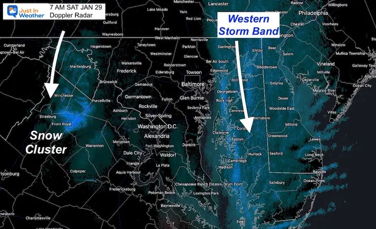
*A cluster of snow developed and was dropping south through Martinsburg – Winchester – Front Royal.
This could produce a dusting to 1 inch of fresh snow.
A well defined ‘back band’ of snow was lined up on The Eastern Shore. The next image will highlight Delmarva better.
Dover DE Radar at 7 AM
This is the Sharp Cutoff I kept mentioning. It is clipping Bel Air, but mostly along the Eastern Shore and keeping most of the snow on Delmarva.
By the beaches, snowfall rates were 1 to 2 inches per hour.

Radar Loop: 2 Hours Ending at 7 AM

Headlines:
- Today: Coastal Storm Bombs Out- Pounds NY to New England
- Saturday Morning: Blizzard at the beaches. Snow on Delmarva will end by noon.
- Winds: Getting stronger! Gusts 40 to 50 mph. Wind Chill to single digits!
- Sunday: Still Colder!
- Next week – Warming with rain in next storm.
Morning Surface Weather
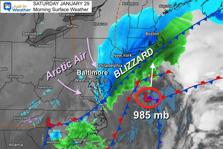
Here is our regional surface map, showing the Low Pressure now lined up east of Ocean City. This is key, as it continues to move north, the winds will increase, and the snow will cut off.
Surface Weather Plot
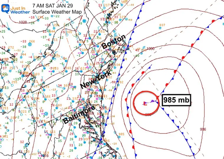
This may look busy, but here are all of the surface observations.. We can see the Low Pressure is now down to 985mb. Truly now bombing out. This type of storm may have an eye on satellite during the day (I’ll be looking for it).
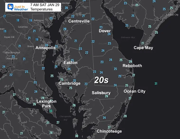
Morning Temperatures
Delmarva –
Special focus while still under the snow.
Wind Chill

Regional View: Temp And Wind
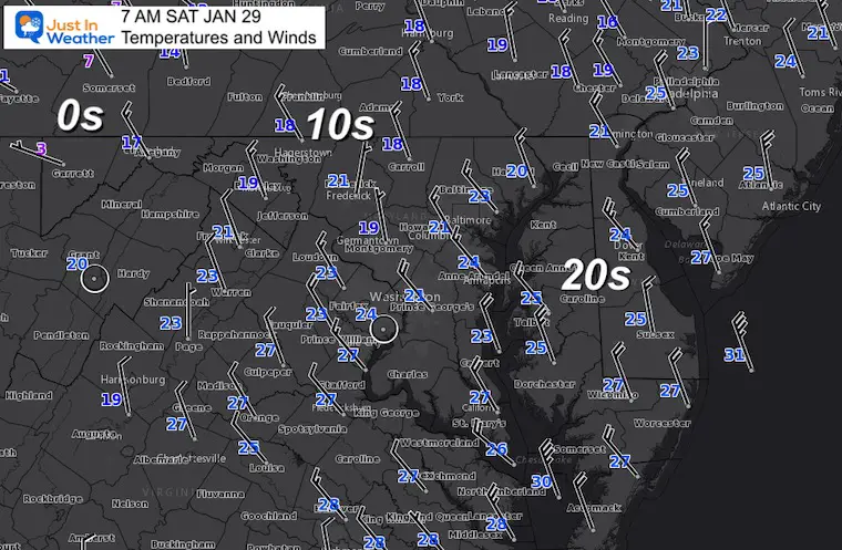
Afternoon Temperatures

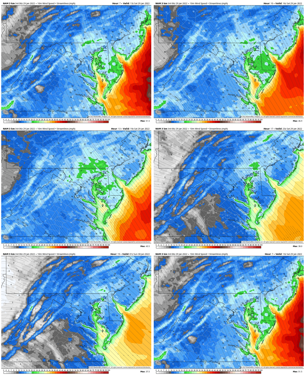
Wind Forecast 8 AM to 8 PM
These are sustained numbers. Gusts will be 30 to 45 mph
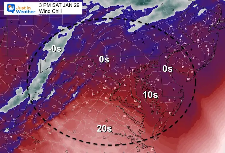
Afternoon Wind Chill
It will feel painful to be outside today!
Weather Almanac: Climate Data
TODAY January 29
Normal Low in Baltimore: 25ºF
Record -7ºF in 1963
Normal High in Baltimore: 42ºF
Record 75ºF 1975
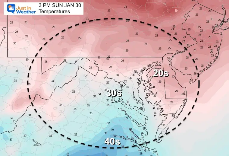
Sunday Temperatures
Morning
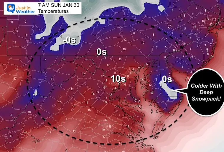
Enhanced COLD in the single digits for interior Delmarva with deep snow pack.
Afternoon
Still cold, but an improvement.
Jumping Ahead….
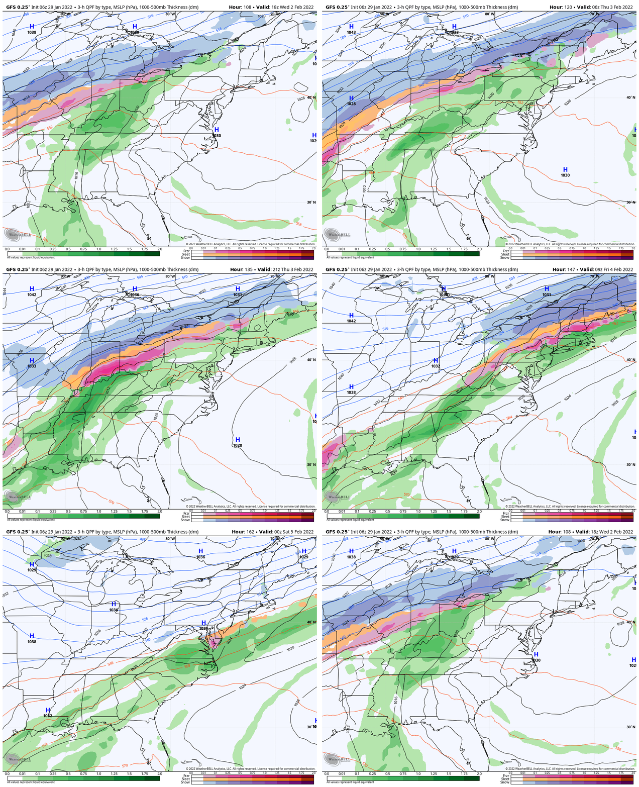
Wednesday to Friday
The next system will take a track well west.
This will warm us up ahead of it, and bring in rain Thursday. That may end with a mix on Friday, with the next round of cold air.
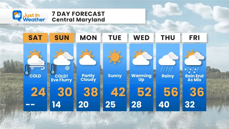
7 Day Forecast
Based on Baltimore at BWI
Bitter cold will follow this storm, then we have a chance to possibly reach 50ºF or higher by the end of next week.
*Disclaimer due to frequent questions:
I am aware there are some spelling and grammar typos. I have made a few public statements over the years, but if you are new here you may have missed it:
I have dyslexia, and found out at my second year at Cornell. I didn’t stop me from getting my meteorology degree, and being first to get the AMS CBM in the Baltimore/Washington region.
I do miss my mistakes in my own proofreading. The autocorrect spell check on my computer sometimes does an injustice to make it worse.
All of the maps and information are accurate. The ‘wordy’ stuff can get sticky.
There is no editor that can check my work when I need it and have it ready to send out in a newsworthy timeline.
I accept this and perhaps proves what you read is really from me…
It’s part of my charm.
#FITF
Weather posts straight to your inbox
Sign up and be the first to know!
ALSO SEE
What is Faith in the Flakes: History of December 5th Snow
ALL FITF GEAR
FITF THUNDERSNOW
Winter Outlook Series:
Last Winter Recap: My Old Outlook And Your Grades Of My Storm Forecasts
Winter Weather Page – Lots of resources
Solar Cycle Increasing Sunspots Suggests More Snow
Comparing 4 Different Farmer’s Almanacs: Majority colder winter outlook than NOAA
NOAA Winter Outlook- But Read The Fine Print
Signals For Early Start To Winter In November
Winter Outlook Series: La Nina Double Dip
Nor’easters May Give Hint For Winter La Nina Pattern
Winter Folklore Checklist


