The second winter storm of the week and season did not disappoint. In fact this behaved rather well on timing. Some may also suggest it did well to over perform.
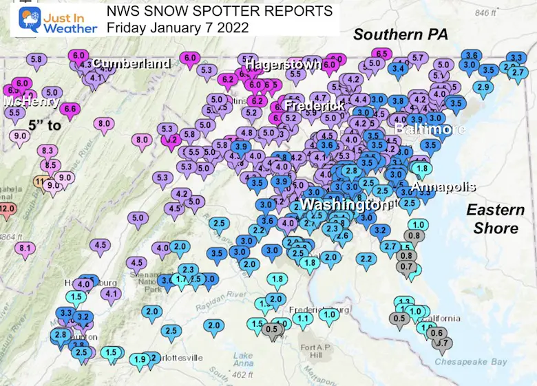
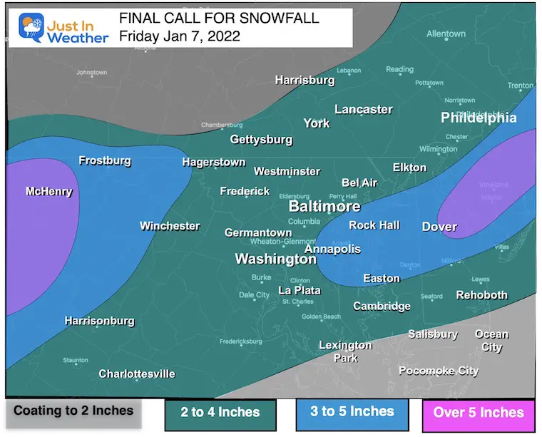
This report has the snow totals around the region. I would like for you to compare them to my final Call For Snowfall.
Below you can see local maps and the list of reports form NWS Baltimore Washington. I am sorry I don’t include others, but there simply is too much to gather.
Regional Snow Total Map
My Final Call For Snowfall
Highlight:
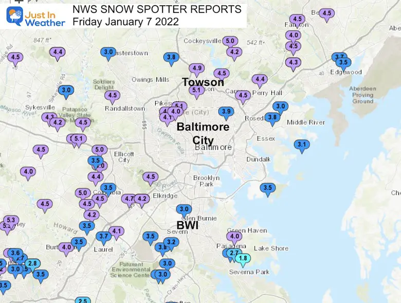
Baltimore’s BWI recorded 3 inches of snow!
Now 9.8” for the month.
This is on pace for the first double digit snow month since the all time record storm in Jan 2016.
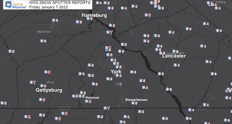
Southern PA Snow
This region averaged over 5 inches. I went too low here, missing the extra few hours of accumulation Thursday evening.
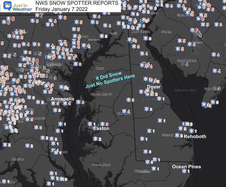
Delmarva Snow
There was a surge in Delaware with the coastal Low intensifying.
The missing data in Kent and Queen Anne’s Counties are because there were no spotters in contact with NWS.
GRADING POLL
I have more notes and the full snow maps and reports below.
[ays_poll id=5]
What I did right:
- I was cautious to not overplay this given computer guidance over performance.
- I also trusted the dry bubble over Baltimore would break around midnight. I put that start time in all of my reports and to all of my clients. The snow began around 12:20 AM in the city.
- I did not get sucked in to a dry slot shown on the HRRR. Last minute wavering is what I try to avoid and trust the initial physics. It worked with some misses.
- Much of the region did seem to get the snow I expected.
- The timing of heaviest snow overnight and ending before sunrise was an easy call this time.
What I got wrong:
- That band of steady snow northwest of Baltimore forcing a few counties to get upgraded to a Winter Storm Warning during the event.
- There ware a lot of higher numbers than expected between Frederick, Westminster, and southern PA.
- I showed a higher range from Annapolis through central Delmarva. This stills pretty close, but my map may have given more credit to it over Kent Island.
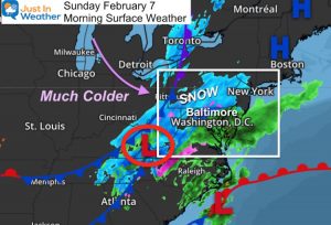
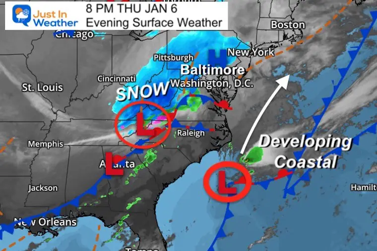
Storm Map
A Miller-B that actually perfumed well for us. They can sometimes leave us in a dry slot in between the transition.
Snow Reports By County
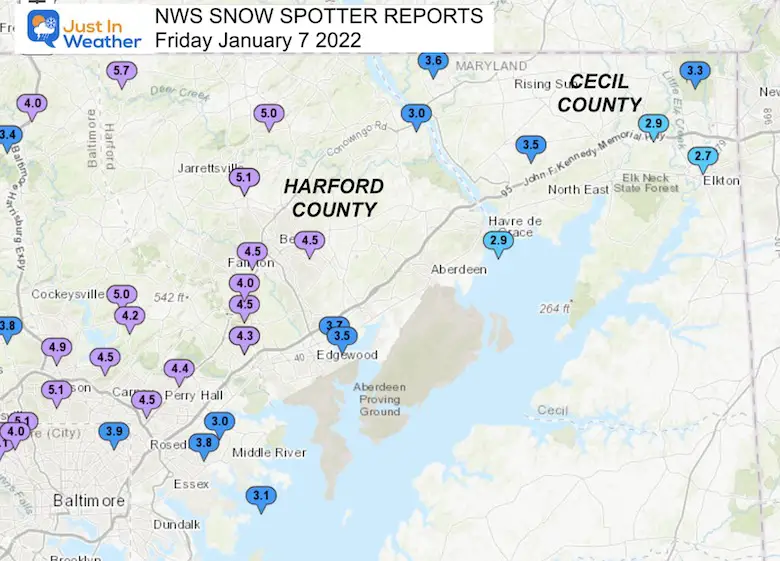
Northeast Maryland
Harford and Cecil Counties
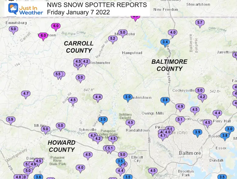
North Central Maryland
Baltimore, Carroll, and Howard Counties
Baltimore City And Surrounding The Beltway
Frederick to Washington Counties
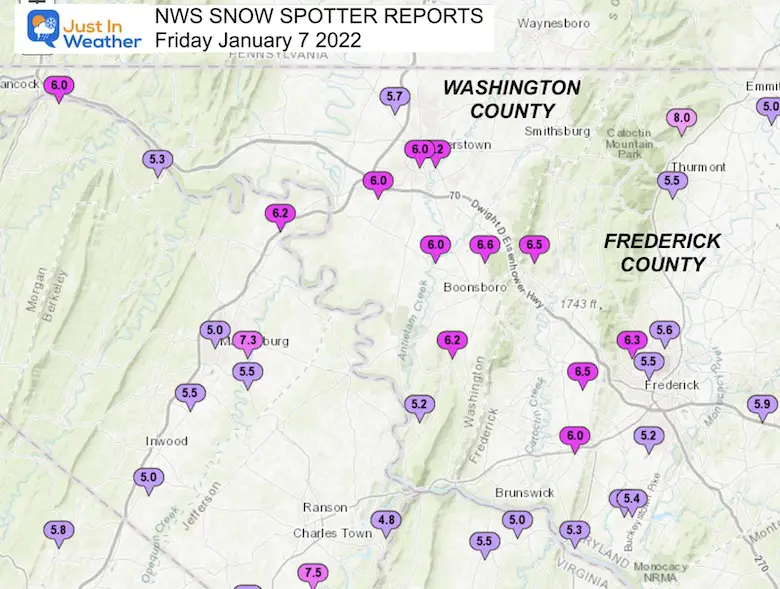
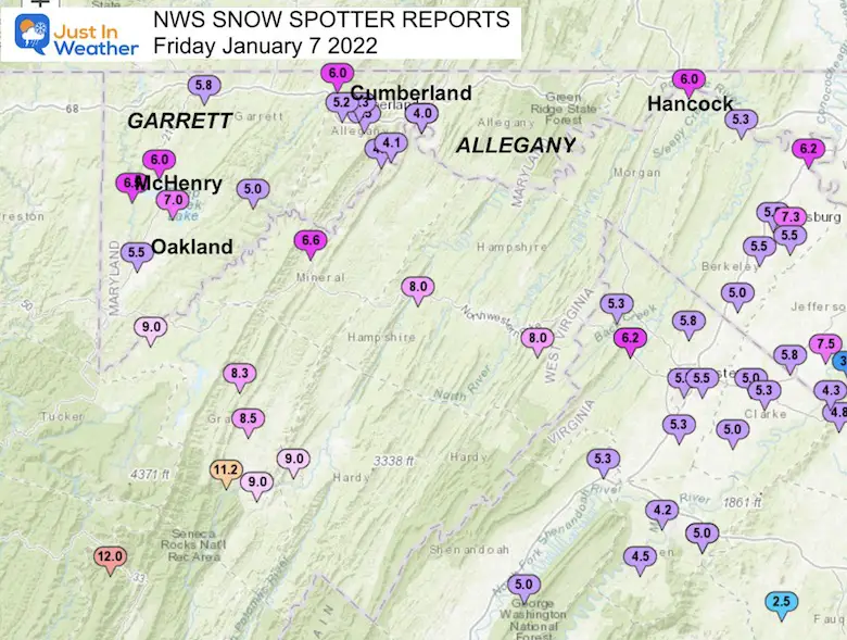
Western Maryland Mountains
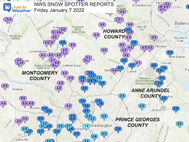
Metro Washington
Southern Maryland
AA, Calvert, Charles, and St. Mary’s Counties
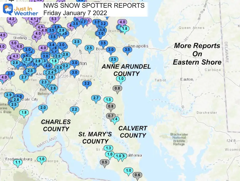
Eastern Shore to Central Delaware
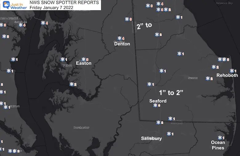
List Of Snow Reports
From NWS Baltimore Washington
********************STORM TOTAL SNOWFALL********************
LOCATION TOTAL TIME/DATE COMMENTS
SNOWFALL MEASURED
(inches)
DISTRICT OF COLUMBIA
…District of Columbia…
American University 3.1 613 AM 1/07 Broadcast Media
National Zoo 1 WSW 2.9 722 AM 1/07 Trained Spotter
Washington 3 NE 2.8 700 AM 1/07 CoCoRaHS
Adams Morgan 2.5 640 AM 1/07 Trained Spotter
Anacostia SSE 2.2 540 AM 1/07 Trained Spotter
MARYLAND
…Allegany County…
Frostburg 2 ESE 5.5 732 AM 1/07 Trained Spotter
Frostburg 5.2 700 AM 1/07 Co-Op Observer
Cresaptown-Bel Air 1 4.6 700 AM 1/07 CoCoRaHS
Frostburg 2 ENE 4.3 932 AM 1/07 Trained Spotter
Cresaptown SSW 4.1 840 AM 1/07 Trained Spotter
Cumberland 1 SSE 4.0 820 AM 1/07 Trained Spotter
Cumberland 4.0 700 AM 1/07 Co-Op Observer
…Anne Arundel County…
Green Haven 1 ESE 4.0 530 AM 1/07 Trained Spotter
Pasadena 1 SE 3.8 700 AM 1/07 CoCoRaHS
Severn 2 SSW 3.8 747 AM 1/07 CoCoRaHS
Annapolis 1 SE 3.5 805 AM 1/07 CoCoRaHS
Severn 2 W 3.5 700 AM 1/07 CoCoRaHS
Crofton 1 SSE 3.5 530 AM 1/07 CoCoRaHS
Odenton 1 WNW 3.3 800 AM 1/07 Trained Spotter
Severn 1 SSE 3.2 700 AM 1/07 CoCoRaHS
Odenton 1 N 3.0 700 AM 1/07 CoCoRaHS
Bwi Airport 3.0 700 AM 1/07 Airport
Riva 2 WNW 3.0 830 AM 1/07 Trained Spotter
Odenton S 3.0 700 AM 1/07 Trained Spotter
Chelsea Beach 2.7 800 AM 1/07 Trained Spotter
Birdsville WSW 2.5 800 AM 1/07 CoCoRaHS
Pasadena 3 ESE 1.8 800 AM 1/07 CoCoRaHS
Deale 1 SE 1.0 700 AM 1/07 CoCoRaHS
…Baltimore County…
Towson 1 SW 5.1 830 AM 1/07 CoCoRaHS
Long Green 2 NW 5.0 600 AM 1/07 Trained Spotter
Timonium NE 4.9 700 AM 1/07 CoCoRaHS
Randallstown 2 NW 4.5 849 AM 1/07 Trained Spotter
Catonsville 1 SSE 4.5 830 AM 1/07 Trained Spotter
Hampton 1 NE 4.5 645 AM 1/07 Trained Spotter
Fullerton 1 N 4.5 935 AM 1/07 Trained Spotter
Perry Hall 1 NNE 4.4 745 AM 1/07 Trained Spotter
Upper Falls 1 NNE 4.3 645 AM 1/07 Trained Spotter
Kingsville 1 E 4.3 700 AM 1/07 CoCoRaHS
Long Green 1 SW 4.2 700 AM 1/07 CoCoRaHS
Bentley Springs 1 E 4.0 550 AM 1/07 Trained Spotter
Cockeysville 3 WSW 3.8 850 AM 1/07 CoCoRaHS
Middle River 1 N 3.8 810 AM 1/07 Trained Spotter
Edgemere ESE 3.5 447 AM 1/07 Trained Spotter
Parkton 1 W 3.4 900 AM 1/07 Trained Spotter
Middle River WSW 3.1 625 AM 1/07 Trained Spotter
White Marsh 2 ESE 3.0 700 AM 1/07 CoCoRaHS
Glyndon 1 SW 3.0 1004 AM 1/07 Trained Spotter
…Baltimore City…
Mount Washington 1 N 5.1 700 AM 1/07 CoCoRaHS
Lochearn 2 ENE 4.5 947 AM 1/07 Trained Spotter
Arlington 1 NNW 4.1 1017 AM 1/07 Trained Spotter
Pimlico SE 4.0 615 AM 1/07 Trained Spotter
Hamilton NE 3.9 600 AM 1/07 CoCoRaHS
…Calvert County…
Huntingtown 3 NNW 1.5 700 AM 1/07 CoCoRaHS
Prince Frederick 1 S 1.4 630 AM 1/07 Trained Spotter
Huntingtown SW 0.8 635 AM 1/07 Trained Spotter
North Beach 2 WNW 0.8 900 AM 1/07 CoCoRaHS
Prince Frederick 1 W 0.7 800 AM 1/07 CoCoRaHS
…Carroll County…
Millers 4 NE 6.5 654 AM 1/07 Co-Op Observer
Taneytown 4 NE 6.0 700 AM 1/07 CoCoRaHS
Taneytown NE 6.0 900 AM 1/07 Trained Spotter
New Windsor 1 ENE 5.8 314 AM 1/07 NWS Employee
Linwood 2 SE 5.5 716 AM 1/07 County Emrg Mgmt
Manchester 1 SSW 5.2 530 AM 1/07 Trained Spotter
Westminster 3 SSW 5.0 700 AM 1/07 CoCoRaHS
Watersville 1 N 5.0 900 AM 1/07 Trained Spotter
Mount Airy SE 5.0 645 AM 1/07 CoCoRaHS
Wagners Mill 1 ENE 5.0 908 AM 1/07 Trained Spotter
Millers 5.0 922 AM 1/07 County Emrg Mgmt
Winfield 1 N 4.5 540 AM 1/07 Trained Spotter
Westminster 1 W 4.5 700 AM 1/07 CoCoRaHS
Gamber 1 WNW 4.4 800 AM 1/07 NWS Employee
Gamber 1 W 4.4 800 AM 1/07 CoCoRaHS
Westminster SE 4.2 700 AM 1/07 Trained Spotter
Eldersburg 1 SE 3.0 645 AM 1/07 Trained Spotter
Eldersburg 1 E 3.0 700 AM 1/07 CoCoRaHS
…Cecil County…
Rock Springs 3.6 645 AM 1/07 Trained Spotter
Woodlawn 2 E 3.5 700 AM 1/07 Trained Spotter
Elkton 7 N 3.3 700 AM 1/07 CoCoRaHS
Elkton 5 NW 2.9 700 AM 1/07 CoCoRaHS
Elkton 1 NNW 2.7 800 AM 1/07 CoCoRaHS
…Charles County…
Waldorf 3 S 2.2 800 AM 1/07 CoCoRaHS
Indian Head 2.0 632 AM 1/07 Trained Spotter
…Frederick County…
Thurmont 3 N 8.0 700 AM 1/07 CoCoRaHS
Pleasant Walk 1 NNE 6.5 804 AM 1/07 Trained Spotter
Braddock Heights 1 N 6.5 600 AM 1/07 Trained Spotter
Bloomfield 2 WSW 6.3 500 AM 1/07 NWS Employee
Jefferson NE 6.0 910 AM 1/07 Trained Spotter
New Market 2 NW 5.9 830 AM 1/07 CoCoRaHS
Frederick 3 N 5.6 852 AM 1/07 CoCoRaHS
Thurmont 1 SSE 5.5 700 AM 1/07 CoCoRaHS
Buckeystown 3 SW 5.5 722 AM 1/07 NWS Employee
Frederick 2 NW 5.5 858 AM 1/07 Trained Spotter
Adamstown 1 ESE 5.4 700 AM 1/07 CoCoRaHS
Point of Rocks 1 NE 5.3 745 AM 1/07 Trained Spotter
Ballenger Creek WSW 5.2 530 AM 1/07 Trained Spotter
Emmitsburg 2 SE 5.0 610 AM 1/07 Co-Op Observer
Union Bridge 7 SSW 4.7 715 AM 1/07 CoCoRaHS
…Garrett County…
McHenry 5 SSE 7.0 800 AM 1/07 CoCoRaHS
Mc Henry 4 SW 6.5 600 AM 1/07 Co-Op Observer
Mc Henry 1 NNE 6.0 715 AM 1/07 County Emrg Mgmt
Mount Savage 4 WNW 6.0 715 AM 1/07 County Emrg Mgmt
Grantsville 5 W 5.8 500 AM 1/07 Dept of Highways
Oakland 5.5 500 AM 1/07 Dept of Highways
Warnocks 4 NW 5.0 600 AM 1/07 HADS
…Harford County…
Norrisville 1 WSW 5.7 615 AM 1/07 CoCoRaHS
Forest Hill 1 NNW 5.1 800 AM 1/07 Trained Spotter
Chrome Hill 2 SE 5.1 800 AM 1/07 CoCoRaHS
Street 1 ESE 5.0 830 AM 1/07 Trained Spotter
Bel Air 2 E 4.5 530 AM 1/07 Trained Spotter
Bel Air 2 W 4.5 800 AM 1/07 Trained Spotter
Kingsville 3 NNE 4.5 700 AM 1/07 CoCoRaHS
Fallston 2 ESE 4.0 900 AM 1/07 CoCoRaHS
Abingdon 3.7 730 AM 1/07 Broadcast Media
Abingdon 1 SE 3.5 814 AM 1/07 Trained Spotter
Conowingo 1 S 3.0 700 AM 1/07 Co-Op Observer
Havre De Grace 1 ESE 2.9 900 AM 1/07 CoCoRaHS
…Howard County…
Woodstock 2 SW 5.1 844 AM 1/07 Trained Spotter
Marriottsville 3 S 5.1 700 AM 1/07 CoCoRaHS
Simpsonville 2 NNW 5.0 1228 PM 1/07 Trained Spotter
Historic Ellicott Ci 5.0 1030 AM 1/07 Trained Spotter
Elkridge 2 W 4.7 700 AM 1/07 CoCoRaHS
Marriottsville 1 SE 4.5 800 AM 1/07 CoCoRaHS
Columbia 4.5 530 AM 1/07 Trained Spotter
Glenelg 2 N 4.5 830 AM 1/07 Trained Spotter
Simpsonville E 4.5 920 AM 1/07 Trained Spotter
Highland 2 WNW 4.5 815 AM 1/07 CoCoRaHS
Columbia 2 N 4.4 700 AM 1/07 CoCoRaHS
Sykesville 2 SSE 4.3 700 AM 1/07 CoCoRaHS
Elkridge NW 4.2 800 AM 1/07 Trained Spotter
Simpsonville 1 SSE 4.2 445 AM 1/07 Trained Spotter
Elkridge 4.2 530 AM 1/07 NWS Employee
Sykesville 3 SE 4.2 700 AM 1/07 CoCoRaHS
Savage 1 ESE 4.1 815 AM 1/07 Trained Spotter
Ellicott City 1 SW 4.0 1035 AM 1/07 Trained Spotter
Roxbury Mills 2 ESE 4.0 750 AM 1/07 Trained Spotter
Savage 1 WSW 3.7 700 AM 1/07 Trained Spotter
Ellicott City 1 WSW 3.5 800 AM 1/07 CoCoRaHS
Columbia 2 NE 3.5 700 AM 1/07 Trained Spotter
Scaggsville 1 ENE 3.5 800 AM 1/07 NWS Employee
…Montgomery County…
Gaithersburg 1 SW 5.5 900 AM 1/07 Trained Spotter
Olney 1 E 5.3 630 AM 1/07 Trained Spotter
Damascus 3 SSW 5.3 400 AM 1/07 Co-Op Observer
Olney 1 ENE 5.3 630 AM 1/07 CoCoRaHS
Poolesville 5.0 715 AM 1/07 County Emrg Mgmt
Germantown 5 NNE 5.0 600 AM 1/07 CoCoRaHS
Clarksburg 2 SE 5.0 545 AM 1/07 Trained Spotter
Clarksburg 1 SSE 4.8 400 AM 1/07 Trained Spotter
Gaithersburg 4.8 950 AM 1/07 Trained Spotter
Damascus 1 S 4.8 733 AM 1/07 Trained Spotter
Gaithersburg 3 NE 4.7 700 AM 1/07 CoCoRaHS
Montgomery Village 1 4.5 830 AM 1/07 Trained Spotter
Poolesville SE 4.5 800 AM 1/07 CoCoRaHS
Damascus 1 SE 4.5 700 AM 1/07 Trained Spotter
Potomac 1 NNW 4.5 700 AM 1/07 CoCoRaHS
Germantown 1 SE 4.5 933 AM 1/07 Trained Spotter
Montgomery Village 1 4.5 630 AM 1/07 CoCoRaHS
Laytonsville 5 NNW 4.5 700 AM 1/07 CoCoRaHS
Rockville 2 NW 4.5 830 AM 1/07 Trained Spotter
Laytonsville E 4.5 700 AM 1/07 CoCoRaHS
Norbeck 1 ESE 4.3 700 AM 1/07 CoCoRaHS
Germantown 2 WSW 4.3 500 AM 1/07 Trained Spotter
Poolesville NE 4.2 100 PM 1/07 Trained Spotter
Rockville 3 E 4.2 800 AM 1/07 CoCoRaHS
North Potomac 4 N 4.1 700 AM 1/07 CoCoRaHS
Burtonsville 4.0 715 AM 1/07 County Emrg Mgmt
Rockville 4.0 715 AM 1/07 County Emrg Mgmt
Potomac 2 N 4.0 800 AM 1/07 Trained Spotter
Glen Echo 1 WNW 4.0 715 AM 1/07 County Emrg Mgmt
Somerset 1 ENE 3.8 630 AM 1/07 Trained Spotter
Dickerson 7 SW 3.8 730 AM 1/07 CoCoRaHS
Colesville 2 W 3.7 700 AM 1/07 CoCoRaHS
Rossmoor 1 ESE 3.6 700 AM 1/07 CoCoRaHS
Laytonsville 2 WNW 3.6 700 AM 1/07 Trained Spotter
Aspen Hill 1 SW 3.5 715 AM 1/07 Trained Spotter
Silver Spring 4 N 3.5 800 AM 1/07 CoCoRaHS
Colesville 3.5 700 AM 1/07 Trained Spotter
Garrett Park 3.5 750 AM 1/07 CoCoRaHS
White Oak 1 N 3.5 700 AM 1/07 CoCoRaHS
Chevy Chase 1 W 3.4 1030 AM 1/07 Trained Spotter
Glenmont 1 NNE 3.0 735 AM 1/07 Trained Spotter
Takoma Park 3.0 715 AM 1/07 County Emrg Mgmt
Takoma Park 1 NNW 3.0 700 AM 1/07 CoCoRaHS
Silver Spring 6 NNE 2.8 430 AM 1/07 CoCoRaHS
…Prince Georges County...
West Laurel 1 N 3.5 800 AM 1/07 CoCoRaHS
Marlton 1 WSW 3.2 800 AM 1/07 Trained Spotter
Suitland 2 SE 3.0 700 AM 1/07 CoCoRaHS
Capitol Heights 3.0 807 AM 1/07 Trained Spotter
Brandywine 7 ESE 2.7 700 AM 1/07 CoCoRaHS
Greenbelt 1 N 2.5 600 AM 1/07 CoCoRaHS
Glenn Dale 1 SE 2.5 830 AM 1/07 CoCoRaHS
…St. Marys County…
California 2 W 1.5 730 AM 1/07 Trained Spotter
Mechanicsville 7 SE 1.3 700 AM 1/07 CoCoRaHS
Leonardtown 1 NE 1.0 600 AM 1/07 CoCoRaHS
Hollywood 3 S 1.0 725 AM 1/07 Trained Spotter
Great Mills 4 S 1.0 700 AM 1/07 CoCoRaHS
Ridge 1 N 0.7 700 AM 1/07 CoCoRaHS
Lexington Park 6 SSE 0.6 900 AM 1/07 CoCoRaHS
Compton 2 ESE 0.5 805 AM 1/07 Trained Spotter
…Washington County…
Boonsboro 3 NNE 6.6 500 AM 1/07 Trained Spotter
Hagerstown 1 ENE 6.2 700 AM 1/07 CoCoRaHS
Keedysville 2 SSE 6.2 700 AM 1/07 CoCoRaHS
Hancock 1 ESE 6.0 700 AM 1/07 CoCoRaHS
Williamsport 3 ENE 6.0 600 AM 1/07 CoCoRaHS
Fairplay 3 ENE 6.0 700 AM 1/07 Trained Spotter
Hagerstown 6.0 700 AM 1/07 Trained Spotter
Hagerstown 4 NNW 5.7 700 AM 1/07 CoCoRaHS
Sharpsburg 5 S 5.2 700 AM 1/07 Co-Op Observer
VIRGINIA
…Albemarle County…
Monticello 2 NNE 2.2 845 AM 1/07 Trained Spotter
Crozet 2.0 724 AM 1/07 Trained Spotter
Charlottesville 2 W 1.9 800 AM 1/07 Co-Op Observer
Crozet 1 W 1.5 800 AM 1/07 CoCoRaHS
…Arlington County…
Arlington 3 W 3.0 830 AM 1/07 CoCoRaHS
Falls Church 1 E 3.0 500 AM 1/07 NWS Employee
Baileys Crossroads 1 3.0 800 AM 1/07 Trained Spotter
Arlington 3 WNW 2.7 700 AM 1/07 CoCoRaHS
Reagan National Apt 2.6 700 AM 1/07 Airport
Rosslyn 1 S 1.8 815 AM 1/07 Trained Spotter
…Augusta County…
Waynesboro 5.0 900 AM 1/07 Trained Spotter
Fort Defiance 3 ESE 4.2 700 AM 1/07 CoCoRaHS
Verona 3 NNW 4.0 700 AM 1/07 CoCoRaHS
Staunton 2 N 4.0 707 AM 1/07 Trained Spotter
Fishersville 1 NE 3.8 700 AM 1/07 Trained Spotter
Mount Solon 4 SSE 3.3 730 AM 1/07 CoCoRaHS
Weyers Cave 1 SSW 3.2 820 AM 1/07 Trained Spotter
…City of Alexandria…
Alexandria 2 W 2.6 807 AM 1/07 CoCoRaHS
Alexandria 1 ENE 2.5 800 AM 1/07 Trained Spotter
Alexandria 1 W 2.4 700 AM 1/07 Trained Spotter
…City of Fairfax…
Fairfax 1 N 3.2 700 AM 1/07 CoCoRaHS
…City of Fredericksburg…
Dunavant 2 SE 1.9 730 AM 1/07 Trained Spotter
…City of Harrisonburg…
Harrisonburg 2 N 3.5 900 AM 1/07 CoCoRaHS
…City of Manassas…
Independent Hill 2 E 3.5 900 AM 1/07 Trained Spotter
Manassas Park 1 SW 2.3 825 AM 1/07 Trained Spotter
…City of Staunton…
Staunton 1 WSW 3.5 700 AM 1/07 CoCoRaHS
Staunton Water Plant 2.8 800 AM 1/07 Co-Op Observer
…City of Waynesboro…
Waynesboro 2 WNW 2.5 810 AM 1/07 CoCoRaHS
…City of Winchester…
Winchester 1 NNE 5.5 600 AM 1/07 Trained Spotter
…Clarke County…
Berryville 1 NNW 5.3 800 AM 1/07 CoCoRaHS
Stringtown 2 WSW 5.0 1200 PM 1/07 Trained Spotter
Boyce 5.0 709 AM 1/07 Broadcast Media
…Culpeper County…
Rixeyville 3 N 3.5 700 AM 1/07 CoCoRaHS
Culpeper 2 WNW 3.0 745 AM 1/07 CoCoRaHS
Reva 1 SSE 2.5 800 AM 1/07 CoCoRaHS
…Fairfax County…
Herndon 1 NNE 5.3 645 AM 1/07 NWS Employee
Chantilly 3 N 4.5 312 AM 1/07 NWS Employee
Reston 2 N 4.5 815 AM 1/07 Trained Spotter
Herndon 3 S 4.3 700 AM 1/07 CoCoRaHS
Herndon 2 ENE 4.0 425 AM 1/07 Trained Spotter
Chantilly 3 E 3.7 530 AM 1/07 Trained Spotter
Centreville 3 SSE 3.5 530 AM 1/07 Trained Spotter
Wolf Trap 2 SSW 3.5 615 AM 1/07 Trained Spotter
Langley 1 SE 3.3 730 AM 1/07 Trained Spotter
Vienna 1 S 3.2 700 AM 1/07 CoCoRaHS
Vienna 3 N 3.2 700 AM 1/07 CoCoRaHS
Vienna 4 NNW 3.0 730 AM 1/07 CoCoRaHS
Merrifield 1 E 3.0 630 AM 1/07 NWS Employee
McLean 2 SE 3.0 700 AM 1/07 CoCoRaHS
Annandale 2 W 3.0 500 AM 1/07 CoCoRaHS
Fairfax 3 SSE 3.0 723 AM 1/07 CoCoRaHS
Falls Church 2 W 2.8 700 AM 1/07 CoCoRaHS
Rose Hill ENE 2.8 1000 AM 1/07 Trained Spotter
Franconia 1 SSE 2.8 700 AM 1/07 CoCoRaHS
Chantilly 2 ENE 2.8 746 AM 1/07 Trained Spotter
Fairfax Station 1 SE 2.7 830 AM 1/07 Trained Spotter
Alexandria 6 SSW 2.7 700 AM 1/07 CoCoRaHS
Alexandria 7 S 2.6 735 AM 1/07 CoCoRaHS
Vienna 2.6 700 AM 1/07 Co-Op Observer
Mantua 1 S 2.5 800 AM 1/07 CoCoRaHS
Franconia 1 SSW 2.3 645 AM 1/07 Trained Spotter
Vienna 1 W 2.2 800 AM 1/07 CoCoRaHS
…Fauquier County…
Warrenton 6 S 3.0 700 AM 1/07 CoCoRaHS
Warrenton 3 SE 3.0 700 AM 1/07 CoCoRaHS
Opal 1 NW 3.0 724 AM 1/07 Trained Spotter
Marshall 8 SW 2.5 700 AM 1/07 CoCoRaHS
Broken Hill 2 E 2.2 400 AM 1/07 NWS Employee
Remington 4 ENE 2.0 600 AM 1/07 CoCoRaHS
…Frederick County…
Gainesboro 2 SW 6.3 826 AM 1/07 Trained Spotter
Hayfield 1 N 6.2 825 AM 1/07 Trained Spotter
Cedar Grove 2 ENE 5.8 1002 AM 1/07 Trained Spotter
Winchester 3 E 5.5 600 AM 1/07 Trained Spotter
Stephens City 2 E 5.3 310 AM 1/07 Trained Spotter
Cross Junction 1 WSW 5.3 816 AM 1/07 Trained Spotter
…Greene County…
Stanardsville 2.0 816 AM 1/07 Trained Spotter
…Highland County…
Mill Gap 1 SW 6.2 500 AM 1/07 Co-Op Observer
Monterey 7 SSW 5.5 700 AM 1/07 CoCoRaHS
Monterey 1 SW 4.2 700 AM 1/07 CoCoRaHS
…King George County…
King George 1 NE 1.0 545 AM 1/07 Trained Spotter
…Loudoun County…
Lovettsville 5.5 500 AM 1/07 County Emrg Mgmt
Arcola 3 S 5.2 415 AM 1/07 Trained Spotter
Sterling Park 1 E 5.0 700 AM 1/07 Trained Spotter
Lovettsville 2 ENE 5.0 700 AM 1/07 Trained Spotter
Round Hill 3 WSW 4.8 1004 AM 1/07 CoCoRaHS
Ashburn N 4.5 800 AM 1/07 Trained Spotter
Hughesville 1 ESE 4.5 900 AM 1/07 Trained Spotter
Leesburg 4 W 4.5 900 AM 1/07 CoCoRaHS
Leesburg 2 NW 4.5 800 AM 1/07 Trained Spotter
Philomont 1 SE 4.3 1003 AM 1/07 Trained Spotter
Dulles International 4.0 700 AM 1/07 Airport
Leesburg 3 E 4.0 630 AM 1/07 CoCoRaHS
Purcellville 2 NNE 4.0 735 AM 1/07 Trained Spotter
Ashburn 2 SW 3.9 415 AM 1/07 NWS Employee
Aldie 3 NW 3.5 1016 AM 1/07 Trained Spotter
…Madison County...
Madison 7 NNW 3.0 700 AM 1/07 CoCoRaHS
Madison 8 NNE 1.7 800 AM 1/07 CoCoRaHS
…Orange County…
Barboursville 1 NW 2.5 800 AM 1/07 CoCoRaHS
Lahore 2 NW 2.0 955 AM 1/07 Trained Spotter
…Page County…
Honeyville 1 ESE 4.5 530 AM 1/07 Trained Spotter
Panorama 2 WSW 4.0 800 AM 1/07 Trained Spotter
…Prince William County...
Manassas Park 1 NNW 4.0 440 AM 1/07 Trained Spotter
Gainesville 3.6 709 AM 1/07 Trained Spotter
Nokesville 4 S 3.0 700 AM 1/07 CoCoRaHS
Dale City 2 NNW 3.0 830 AM 1/07 County Emrg Mgmt
Manassas 6 SE 3.0 530 AM 1/07 CoCoRaHS
Haymarket 6 N 3.0 700 AM 1/07 CoCoRaHS
Independent Hill 3 N 2.9 500 AM 1/07 Trained Spotter
Manassas 5 SE 2.9 600 AM 1/07 CoCoRaHS
Dale City 1 W 2.8 815 AM 1/07 Trained Spotter
Independent Hill 3 E 2.5 700 AM 1/07 Trained Spotter
Dumfries 1 ENE 1.8 755 AM 1/07 Trained Spotter
…Rappahannock County...
Boston 2 WSW 2.3 800 AM 1/07 CoCoRaHS
Sperryville 2.0 500 AM 1/07 Co-Op Observer
...Rockingham County…
Timberville 3 NW 4.5 740 AM 1/07 Trained Spotter
Massanutten 1 SE 4.1 728 AM 1/07 Trained Spotter
Dale Enterprise 1 ES 4.0 736 AM 1/07 Trained Spotter
Bridgewater SE 1.5 800 AM 1/07 CoCoRaHS
…Shenandoah County…
Strasburg 4 N 5.3 700 AM 1/07 CoCoRaHS
Edinburg 2 E 5.0 800 AM 1/07 Trained Spotter
…Spotsylvania County…
Alsop 3 NW 1.5 700 AM 1/07 Trained Spotter
Fredericksburg 5 SSW 1.0 600 AM 1/07 CoCoRaHS
Spotsylvania Courtho 0.5 830 AM 1/07 CoCoRaHS
Spotsylvania Courtho 0.5 721 AM 1/07 Trained Spotter
…Stafford County…
Holly Corner 1 ENE 2.0 800 AM 1/07 NWS Employee
Roseville 2 WNW 1.8 715 AM 1/07 Trained Spotter
Fredericksburg 8 ESE 1.1 700 AM 1/07 CoCoRaHS
…Warren County…
Linden 3 W 5.0 841 AM 1/07 Trained Spotter
Front Royal 3 ESE 5.0 907 AM 1/07 CoCoRaHS
Karo 1 WSW 4.5 545 AM 1/07 Trained Spotter
Riverton 1 WNW 4.2 545 AM 1/07 Trained Spotter
WEST VIRGINIA
…Berkeley County…
Martinsburg 2 E 7.3 700 AM 1/07 Trained Spotter
Falling Waters 2 N 6.2 800 AM 1/07 Trained Spotter
Martinsburg Arpt 1 N 5.5 600 AM 1/07 Trained Spotter
Martinsburg 3 SE 5.5 800 AM 1/07 CoCoRaHS
Bunker Hill SE 5.0 620 AM 1/07 Trained Spotter
Martinsburg 5.0 700 AM 1/07 Co-Op Observer
…Grant County…
Cabins 1 NNE 11.2 937 AM 1/07 Trained Spotter
Bayard 9.0 700 AM 1/07 Co-Op Observer
Petersburg 9.0 700 AM 1/07 Co-Op Observer
Maysville 1 ESE 8.5 830 AM 1/07 Trained Spotter
Scherr 8.3 854 AM 1/07 Trained Spotter
…Hampshire County…
Capon Bridge 5 SW 8.0 600 AM 1/07 Trained Spotter
Romney 1 SW 8.0 700 AM 1/07 Co-Op Observer
…Hardy County…
Rig NW 9.0 700 AM 1/07 CoCoRaHS
…Jefferson County…
Bloomery 2 WSW 7.5 620 AM 1/07 Trained Spotter
Rippon 2 W 5.8 551 AM 1/07 NWS Employee
Millville 1 ESE 4.8 715 AM 1/07 Trained Spotter
Harpers Ferry 13 SSW 4.3 430 AM 1/07 CoCoRaHS
Bloomery 3 SSE 3.9 715 AM 1/07 Trained Spotter
…Mineral County…
Keyser 2 SSW 6.6 700 AM 1/07 Co-Op Observer
…Morgan County…
Cherry Run 5.3 600 AM 1/07 Trained Spotter
…Pendleton County…
Seneca Rocks 5 WNW 12.0 514 AM 1/07 Dept of Highways
Franklin 8.1 601 AM 1/07 Dept of Highways
Weather posts straight to your inbox
Sign up and be the first to know!
ALSO SEE
What is Faith in the Flakes: History of December 5th Snow
ALL FITF GEAR
FITF THUNDERSNOW
Winter Outlook Series:
Last Winter Recap: My Old Outlook And Your Grades Of My Storm Forecasts
Winter Weather Page – Lots of resources
Solar Cycle Increasing Sunspots Suggests More Snow
Comparing 4 Different Farmer’s Almanacs: Majority colder winter outlook than NOAA
NOAA Winter Outlook- But Read The Fine Print
Signals For Early Start To Winter In November
Winter Outlook Series: La Nina Double Dip
Nor’easters May Give Hint For Winter La Nina Pattern
Winter Folklore Checklist
Please share your thoughts, best weather pics/video, or just keep in touch via social media
Facebook: Justin Berk, Meteorologist
Twitter: @JustinWeather
Instagram: justinweather


