December 15 2023
Friday Night Update
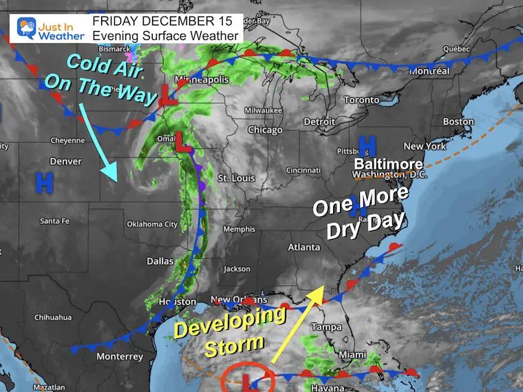
I am noticing a pattern develop that may be helpful for snow lovers in the winter season. We have another weekend storm that will develop in the Gulf of Mexico and roll up the East Coast.
This storm track has shifted east, and there may be a little more wiggle room with the track, considering it has not developed yet. However, this is support for the El Niño storm track mentioned in the winter outlook.
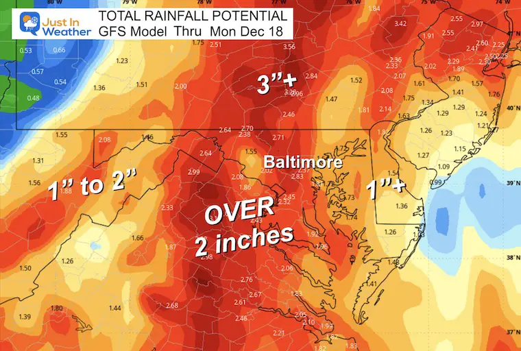
The precipitation is definitely continuing to eat away at the drought (yes it still is a thing here). This storm may bring another widespread 2+ inches of rainfall to much of Central Maryland to Central Pennsylvania. There may be Flood Watches issued over the weekend.
While the storm is lacking cold air, there will be an attempt for the next cold air mass to catch up at the tail end after it passes. This may not be a ‘snow event’, but snow showers and flurries are looking likely. This is also a signal of the atmosphere trying to link up the ingredients as we progress through winter.
Friday Night Set Up
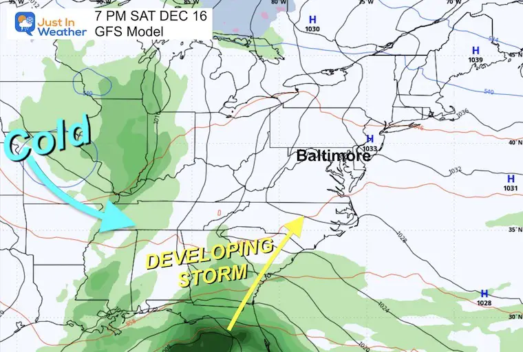
The storm in the MidWest is not ours, but it will play a role. The trailing cold front through Houston is what will join up with Low Pressure in the Gulf of Mexico to develop our storm Saturday night. It will also pull down colder air from the Northern Plains, which will catch up to us just after the storm passes.
Saturday Night
Our storm will still be taking form in the Gulf of Mexico. There will be rapid development into Sunday as the system expands north in our direction.
Animation Sunday Morning to Tuesday Morning
Sunday Night
The rain is expected to develop by the afternoon. The heaviest rain will fall overnight.
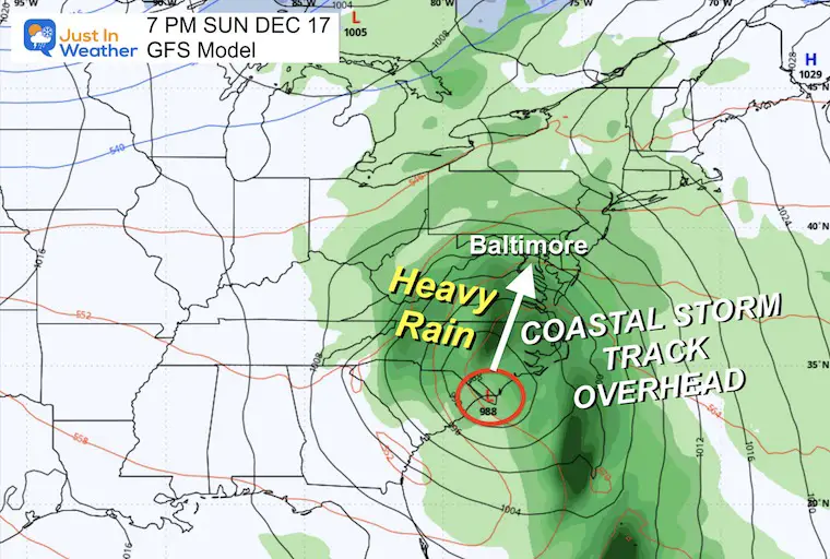
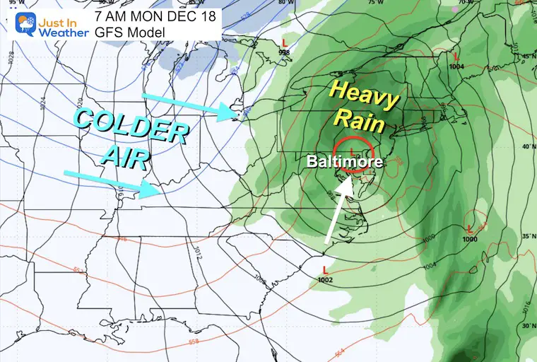
Monday Morning
The track of Low Pressure may be close to the Chesapeake Bay. This will bring the heaviest rain in the morning to the north. Strong winds may lull as it passes, then followed by a period of dry and mild conditions.
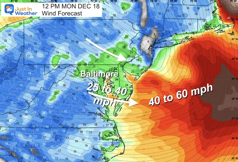
Wind Gusts: Noon Monday
Winds 25 to 40 mph.
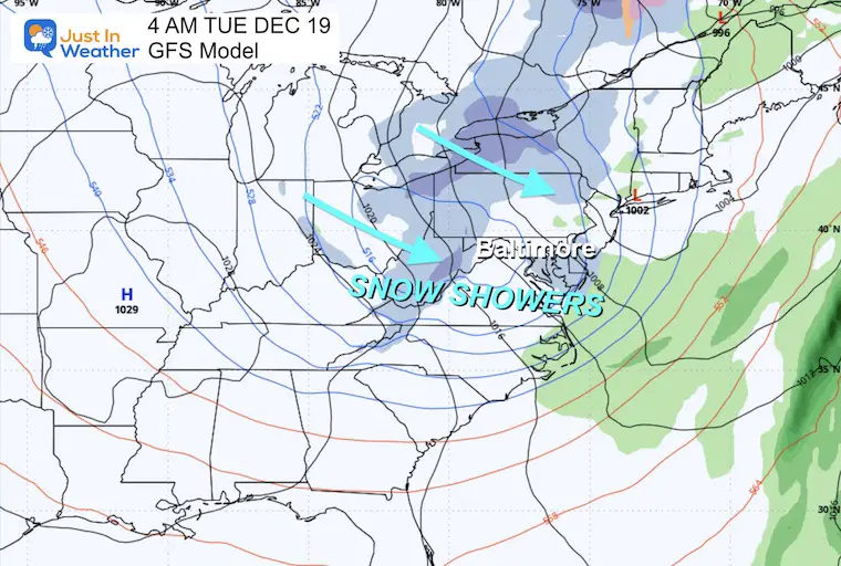
Tuesday Morning
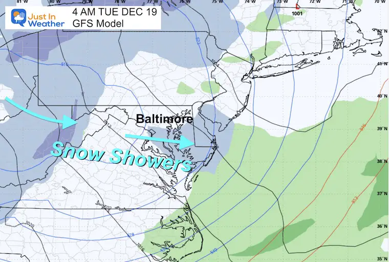
This is when it could get fun. The upper-level energy with the colder air may bring a burst of snow showers and flurries Monday night into Tuesday.
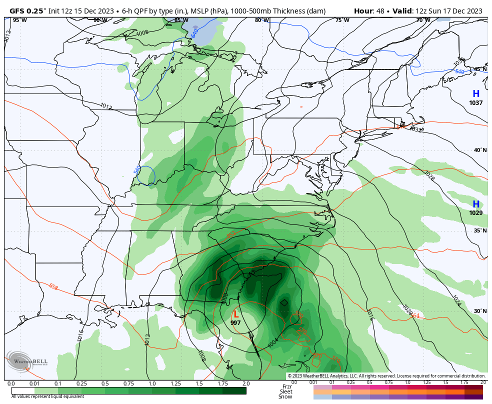
Rainfall Potential
The core of the moderate to heavy rainfall is expected to be west of the Chesapeake Bay. This is subject to change with any shift in the track as the storm takes form.
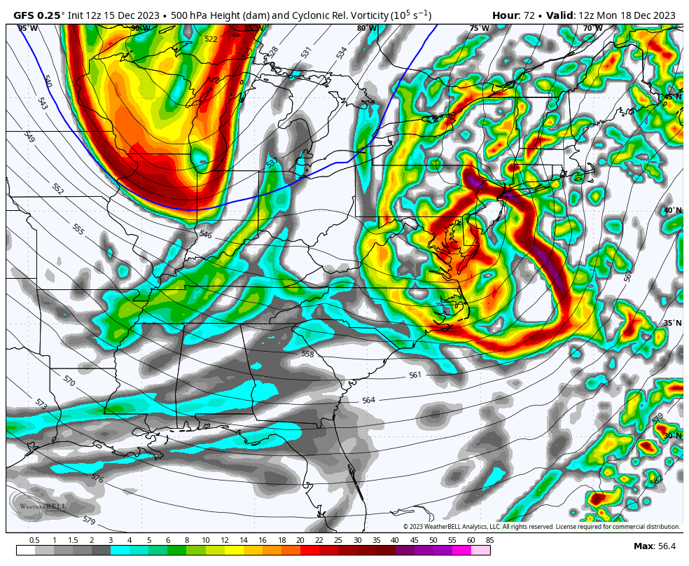
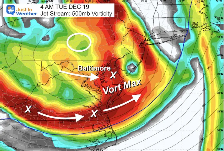
Jet Stream: Vorticity Monday Morning To Tuesday Evening
This is the upper-level energy that will follow the storm. It is set to track through Monday night into Tuesday morning.
Tuesday Morning
Vorticity
The peak spin or Vort Max will pivot through overnight. This will be followed by more instability throughout the day.
Surface Weather
Snow showers are showing here, but the model does not plot this pattern well. There is support for additional snow showers and flurries.
I will have my complete forecast update on Saturday morning.
RECENT Winter Outlook Reports:

El Niño Winter Updates

Computer Models Support East Coast Storm Track

El Niño Advisory
The latest NOAA report is confident in a Very Strong event. Possibly HISTORIC! This refers to the temperatures in the Pacific, with impacts on the US Winter Storm Track.

Winter Weather Folklore: Top 20 and more signals from nature for snow.
NOAA’s Winter Outlook 2024
Winter Outlook 2024 From Two Farmers Almanacs Return to Cold and Snow
Subscribe for eMail Alerts
Explore More
Maryland Snow Climate History And Other Winter Pages

Faith in the Flakes Gear

STEM Assemblies/In School Fields Trips Are Back
Click to see more and ‘Book’ a visit to your school

Subscribe for eMail Alerts
Please share your thoughts and best weather pics/videos, or just keep in touch via social media
RESTATING MY MESSAGE ABOUT DYSLEXIA
I am aware there are some spelling and grammar typos and occasional other glitches. I take responsibility for my mistakes and even the computer glitches I may miss. I have made a few public statements over the years, but if you are new here, you may have missed it: I have dyslexia and found out during my second year at Cornell University. It didn’t stop me from getting my meteorology degree and being the first to get the AMS CBM in the Baltimore/Washington region. One of my professors told me that I had made it that far without knowing and to not let it be a crutch going forward. That was Mark Wysocki, and he was absolutely correct! I do miss my mistakes in my own proofreading. The autocorrect spell check on my computer sometimes does an injustice to make it worse. I also can make mistakes in forecasting. No one is perfect at predicting the future. All of the maps and information are accurate. The ‘wordy’ stuff can get sticky. There has been no editor who can check my work when I need it and have it ready to send out in a newsworthy timeline. Barbara Werner is a member of the web team that helps me maintain this site. She has taken it upon herself to edit typos when she is available. That could be AFTER you read this. I accept this and perhaps proves what you read is really from me… It’s part of my charm.
#FITF


