June 2 Hot Today And Air Quality Alert With Wildfire Smoke From NJ
June 2, 2023
Friday Update
If you smelled smoke yesterday, it was from a more local source. In the last month, we had wildfire smoke high in the atmosphere from western Canada, and more recently from Eastern Canada in Nova Scotia. Yesterday, a 5,000-acre fire in central New Jersey was the source. With winds from the Northeast, it helped to push that lower-level smoke into Delaware and Maryland.
We will have more on the way as the atmosphere has trapped the pollution on this hot day ahead. Then with cooler winds this weekend, it will continue from that source region.
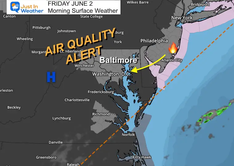
Morning Surface Weather
High Pressure is in control and has trapped pollutants in the lower atmosphere. If you have smelled smoke, this is due to a wildfire in New Jersey. There will be more of that heading our way.
Air Quality Alert: Code Orange for central Maryland, Delaware, and New Jersey,
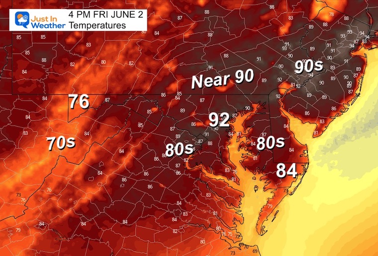
Today will bring more widespread temps into the lower 90s, for just one day. Cooler air is on the way tomorrow.
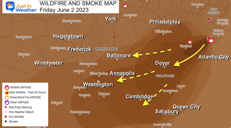
Wildfire Smoke
The local source region has been New Jersey with over 5,000 acres burning. At the last check, this has been 50% contained but is still sending smoke at lower levels into Delaware and Maryland.
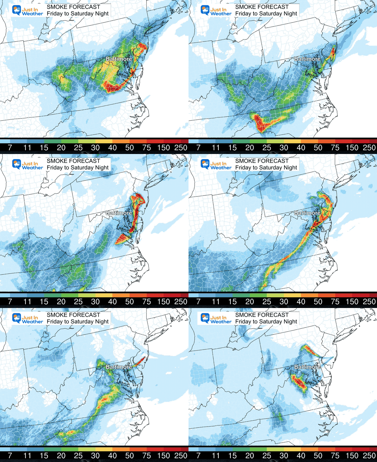
Smoke Forecast Friday to Saturday
We still see the smoke pulse and the winds will continue to send some into our region. The more it is contained will determine when this will stop.
Afternoon Temperatures
These will be our highest temperatures of the year (so far).
Explore More:
2023 Hurricane Season Forecast With An El Niño Watch
Subscribe for eMail Alerts
Weather posts straight to your inbox
Sign up and be the first to know!
CLIMATE DATA
TODAY June 2
Normal Low in Baltimore: 59ºF
Record 44ºF in 1993
Normal High in Baltimore: 80ºF
Record 96ºF in 1923
Saturday
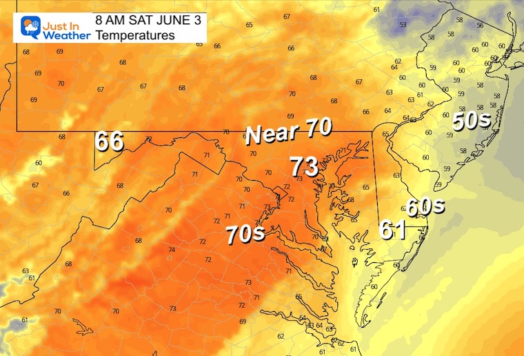
Morning Temperatures
This may be the warmest part of the day.
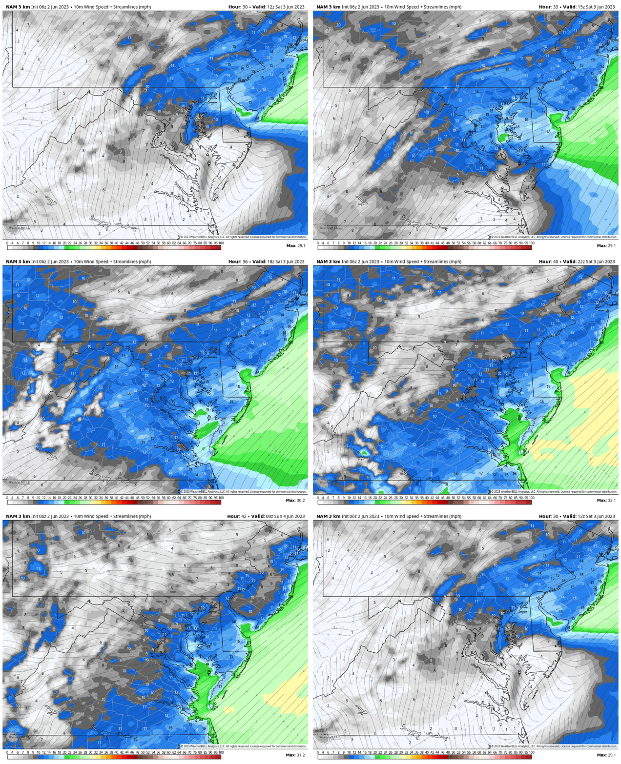
Wind Forecast: 8 AM to 8 Pm Saturday
A backdoor cold front will bring another push of cooler winds from the East! This may bring in cooler temps for the afternoon.
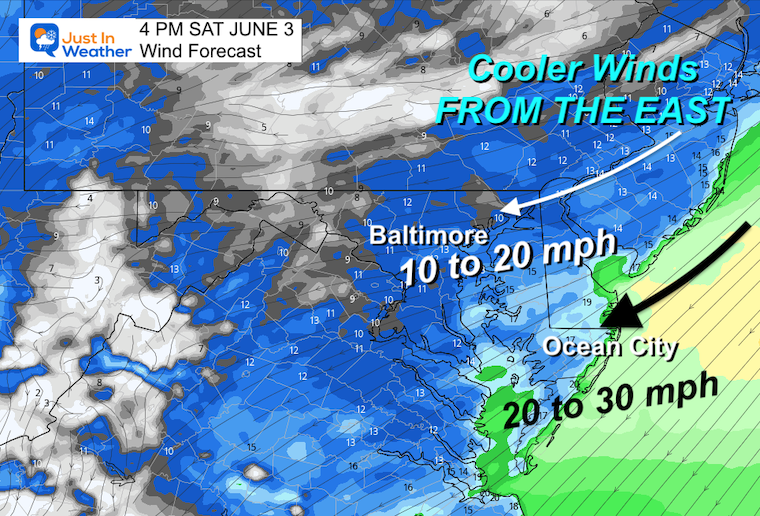
Snapshot at 4 PM
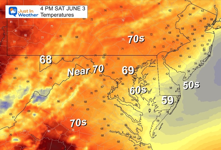
We will see winds between 10 and 30 mph, with a stronger push on Delmarva and by the beaches. That is where temps may drop into the 60s.
Afternoon Temperatures
The modeling does appear to be very cool and I question if this is truly valid. We may end up with warmer temps in the morning. The 60s may not be as widespread as this but are more likely near the water.
NEXT WEEK
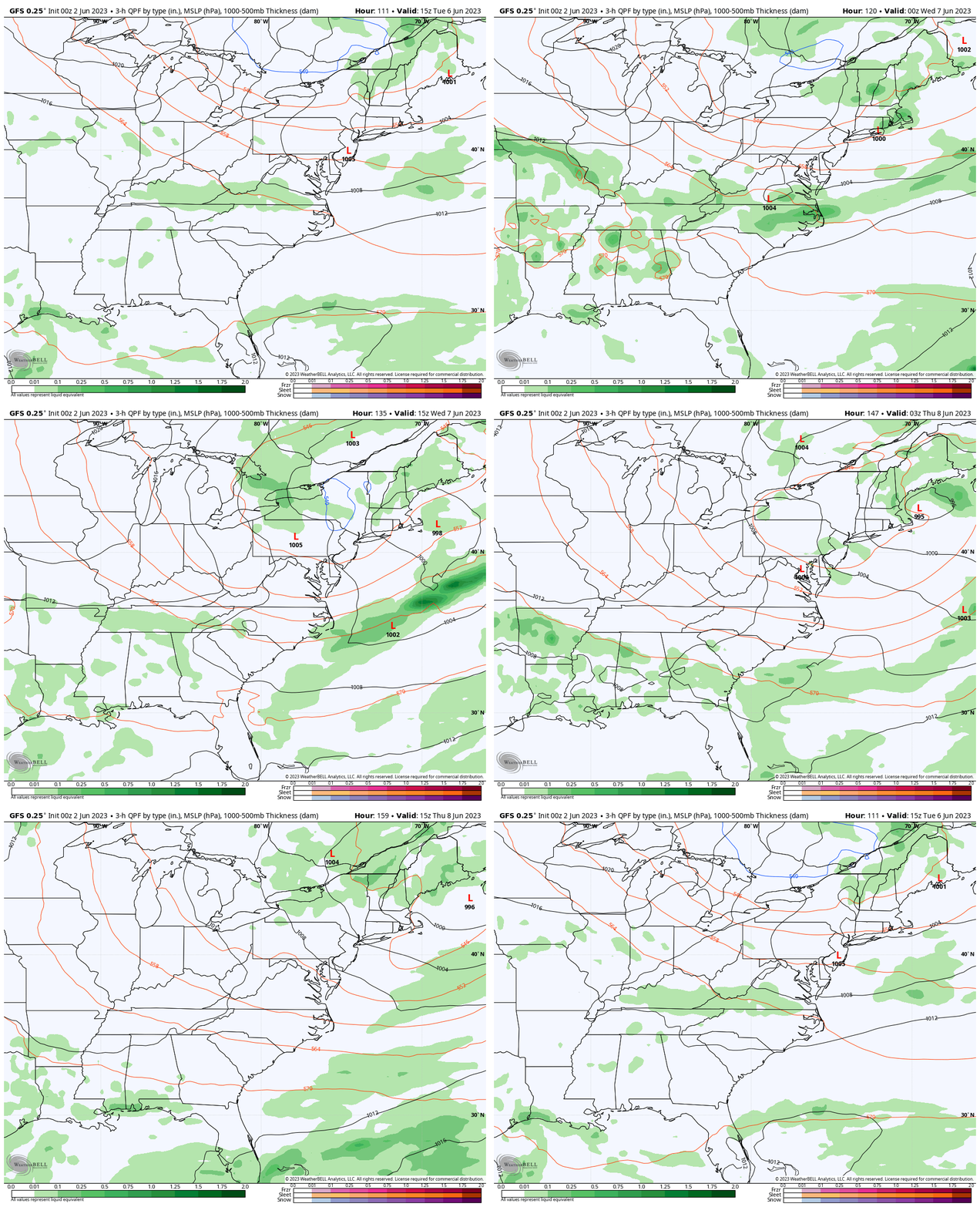
Storm Animation: Tuesday to Thursday
While we remain under the influence of cooler air with a storm off the New England coast, we only seem to generate a small chance for showers on Wednesday.
7 Day Forecast
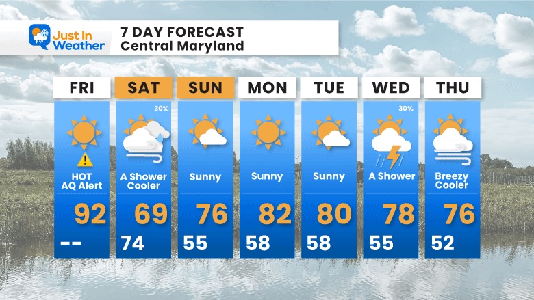
After one day of heat and poor air quality, we will have a cool down this weekend. I am not optimistic for rain and our drought will be building! Next week temperatures will be holding near or slightly cooler than average.
Subscribe for eMail Alerts
Weather posts straight to your inbox
Sign up and be the first to know!
La Niña Has Ended. El Niño May Return By Fall
Aurora Photos From Maryland, Delaware, and Virginia
Please share your thoughts, best weather pics/videos, or just keep in touch via social media
-
Facebook: Justin Berk, Meteorologist
-
Twitter
-
Instagram
RESTATING MY MESSAGE ABOUT DYSLEXIA
I am aware there are some spelling and grammar typos, and occasional other glitches. I take responsibility for my mistakes, and even the computer glitches I may miss. I have made a few public statements over the years, but if you are new here you may have missed it: I have dyslexia, and found out during my second year at Cornell University. It didn’t stop me from getting my meteorology degree, and being first to get the AMS CBM in the Baltimore/Washington region. One of my professors told me that I had made it that far without knowing, and to not let it be a crutch going forward. That was Mark Wysocki and he was absolutely correct! I do miss my mistakes in my own proofreading. The autocorrect spell check on my computer sometimes does an injustice to make it worse. I also can make mistakes in forecasting. No one is perfect predicting the future. All of the maps and information are accurate. The ‘wordy’ stuff can get sticky. There has been no editor that can check my work when I needed it and have it ready to send out in a newsworthy timeline. Barbara Werner is a member of the web team that helps me maintain this site. She has taken it upon herself to edit typos, when she is able. That could be AFTER you read this. I accept this and perhaps proves what you read is really from me… It’s part of my charm.
#FITF


