Pennsylvania Snow Winning Totals And Best Model Forecast To Help With Next Storm
March 7, 2023
The clipper type weather system that moved through overnight and early this morning dropped the expected path of snow across Pennsylvania. I had been highlighting this event (just north of my general forecast area), for the primary purpose of seeing which model would perform best. I hypothesized that the winning model forecast with this event would jump to the top of the projections for the end of week weather event.
What I have gathered below has surprised me, and has forced me to rethink the potential snow for Friday…
Northern Pennsylvania Snow Overnight
This was Tweeted by The National Weather Service in Stage College, but for their Northern Tier.
It is a winter wonderland at the US-219/US-6 intersection in McKean County (Lantz Corners) this evening! Heavy snowfall rates have resulted in slick, snow-covered roads. Use caution if you’re traveling tonight!#PAwx pic.twitter.com/WsuYOpAohs
— NWS State College (@NWSStateCollege) March 7, 2023
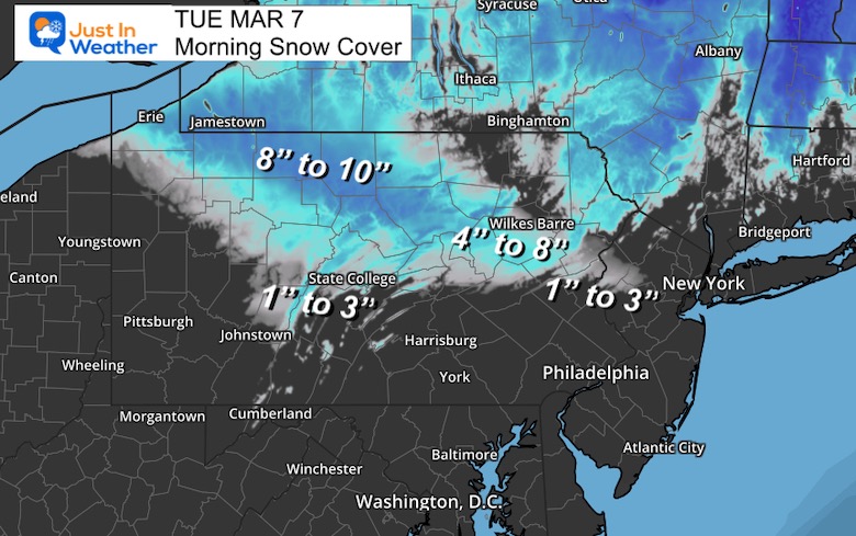
Snow Depth Tuesday Morning
This is a full view of my headline image showing the depth of snow on the ground this morning. This blends with previous snow in New York.
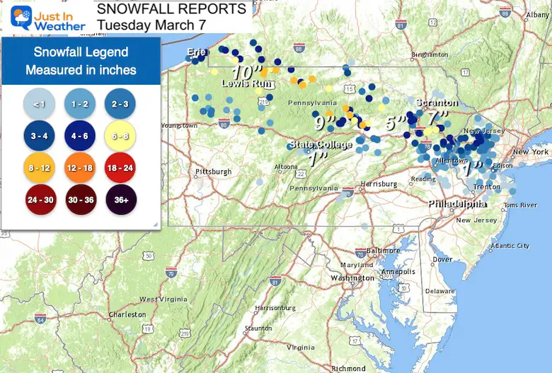
Snowfall Report Map
The collection from weather spotters with the National Weather Service. The base map may make it difficult to read.
Top snow was
- 10” in Lewis Run
- 9” in Cogan House, Haneyville, Coudersport, and Bradford
- 6” to 8” in many location across the Northern Tier of PA and parts of the Poconos.
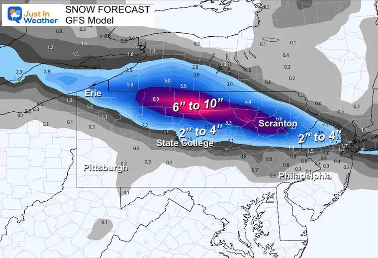
Winning Model: GFS
This is the map I showed in my report last night. It was the higher end of totals, but very close to the coverage matched in the maps above.
Other Models —> slider
COMPARE TO REPORT ABOVE
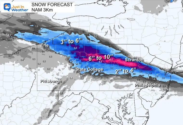
- 2nd Place NAM 3 Km. This was very close to the GFS, but I deducted points for the southern extent of the snow. It showed more snow for State College, PA than the GFS.
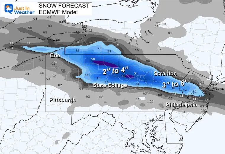
- 3rd Place goes the European Model. It showed lower totals, and accumulation into southern PA. There was snow into York County and northern Maryland, but stickage was isolated.
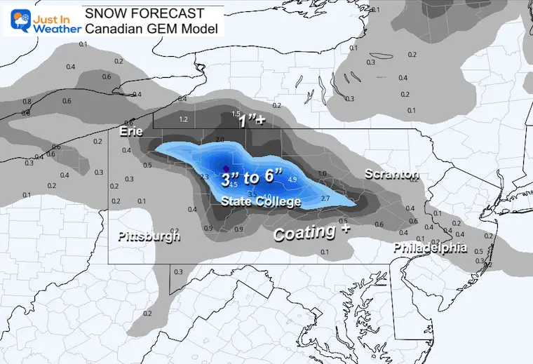
- Last Place goes to the Canadian GEM Model
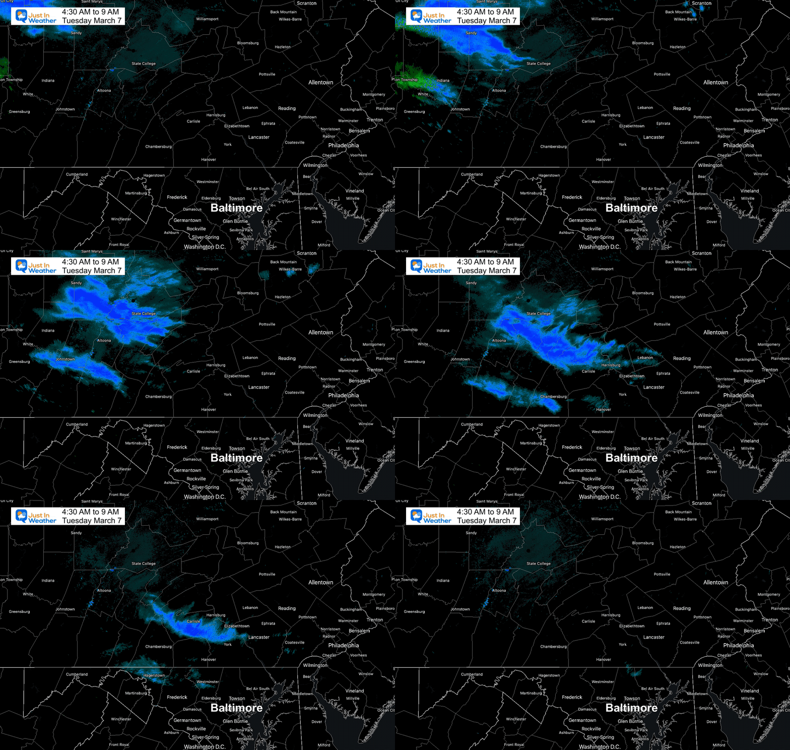
Radar Loop This Morning
The snow band was forecast to reach into Maryland, and it did between 7 AM and 9 AM. Here is a look that confirms what many saw near Westminster and Mount Airy.
Snow In York County
The brief coating was in Hanover (southern York County)
Hanover, PA pic.twitter.com/dD0JwyDfNY
— Brad Stickler (@BradStickler) March 7, 2023
What do we do with this information?
The GFS gets the nod and will be taken more seriously with the next event. I was surprised given the many times it has overplayed storms and lost out to the European Model. While I still believe there is a bias too far south, I will be comparing this in my next report.
Here is a quick preview. I will explore more in my next report this evening.
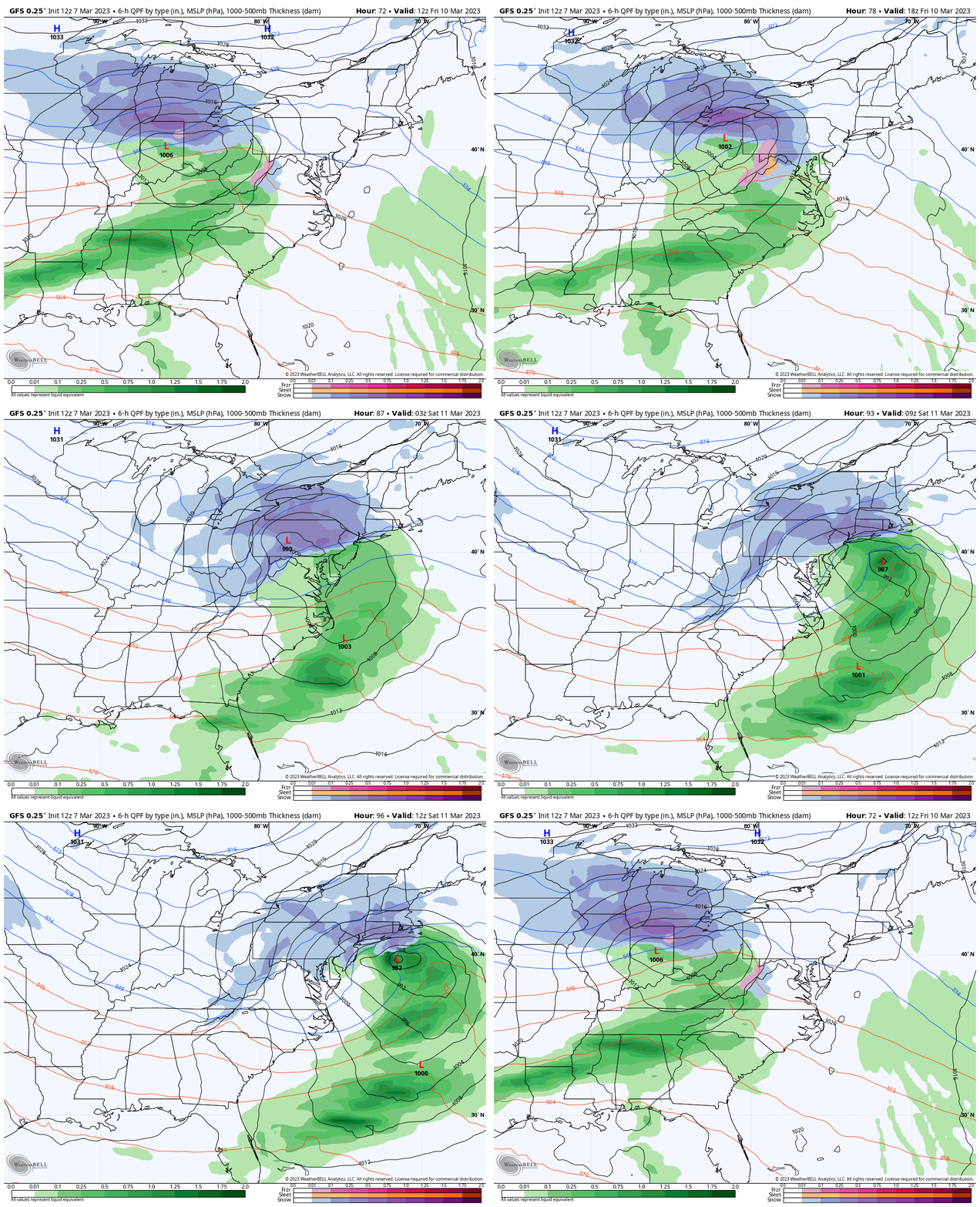
GFS Model Projection
7 AM Friday to 4 PM Saturday
This has sped up again, but also looking better organized for the arrival on Friday. It will have plenty of obstacles I will mention below.
4 PM Snapshot
This is NOT Ideal for 4 reasons
- Snow falling during the day has more hindrance to stick with the higher March sun angle.
- The ground will have a few nights of freezing temps to chill, but still plenty of latent warmth.
- The track of the Low in Pennsylvania can often result with the mountains breaking up the moisture for Central Maryland.
- The bias of this model (among others) all winter, has been to plot storms farther south than they verify.
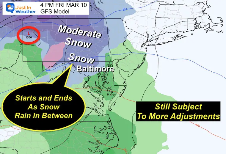
If you want snow, you want the track farther south than shown here. If this ends up north, it would diminish snow chances.
Stand by…. I will compare to other models and add further insight in my next report on this event.
This is still NOT set in stone and I expect more adjustments for timing and track.
Subscribe for eMail Alerts
Weather posts straight to your inbox
Sign up and be the first to know!
IN CASE YOU MISSED IT
My REALISTIC Expectations for the COLD OUTLOOK
Also See:
Winter History: Low Snow And Late Starts
See my research based on Baltimore data since 1883.
RESTATING MY MESSAGE ABOUT DYSLEXIA
I am aware there are some spelling and grammar typos, and occasional other glitches. I take responsibility for my mistakes, and even the computer glitches I may miss.
I have made a few public statements over the years, but if you are new here you may have missed it:
I have dyslexia, and found out during my second year at Cornell University. It didn’t stop me from getting my meteorology degree, and being first to get the AMS CBM in the Baltimore/Washington region. One of my professors told me that I had made it that far without knowing, and to not let it be a crutch going forward. That was Mark Wysocki and he was absolutely correct!
I do miss my mistakes in my own proofreading. The autocorrect spell check on my computer sometimes does an injustice to make it worse. I also can make mistakes in forecasting. No one is perfect predicting the future.
All of the maps and information are accurate. The ‘wordy’ stuff can get sticky.
There has been no editor that can check my work when I needed it and have it ready to send out in a newsworthy timeline. Barbara Werner is a member of the web team that helps me maintain this site. She has taken it upon herself to edit typos, when she is able. That could be AFTER you read this.
I accept this and perhaps proves what you read is really from me…
It’s part of my charm.
#FITF
STEM Assemblies/In School Fields Trips Are Back
Click to see more and ‘Book’ a visit to your school
My Winter Outlook: Not A Typical La Niña!
I see many factors to support colder influence with multiple systems. Early and later in winter. Check it out. https://justinweather.com/2022/11/22/winter-outlook-2023-for-snow-not-typical-la-nina-plus-polar-vortex-disruption/
Also See The Winter Outlook Series:
Farmer’s Almanac Comparison
September Starts Meteorological Autumn: Weather Climate Stats For Maryland at Baltimore
Triple Dip La Niña Winter
https://justinweather.com/2022/09/09/winter-outlook-2023-la-nina-triple-dip-expectations/
CONNECTION TO WINTER?
If you want a snowy winter, this is what you might want to look for in the rest of the tropical season. https://justinweather.com/2022/08/31/record-august-for-no-named-tropical-storms-closer-look-at-snow-following/
Woolly Bear Caterpillars
https://justinweather.com/2022/10/25/winter-weather-outlook-from-the-wooly-bear-caterpillar/
Persimmon Seeds
Click to see Top 20 and MORE
Normals And Records: Maryland and Baltimore Climate History
Please share your thoughts, best weather pics/videos, or just keep in touch via social media
-
-
Facebook: Justin Berk, Meteorologist
-
Twitter: @JustinWeather
-
Instagram: justinweather
-


