Snow Reports From The February 17 Storm
Saturday, February 17 2024
This was the second time this winter we had two snow events in a four-day period. The first two in January both reached or surpassed expectations. This week’s dual events both ended up underperforming in many areas, while some hit or even overachieved.
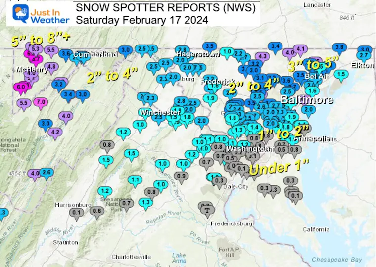
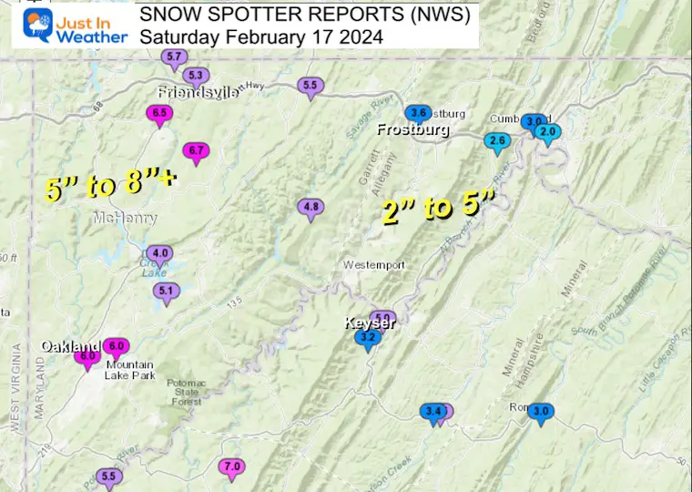
Baltimore’s BWI did record 2.2 inches of snow, which is on target with my forecast all the way. But the north end did not hit the high end.. with the exception of the 6 to 10 inches of snow in a narrow band just north of Harrisburg. Far Western Maryland did hit the high-end snow, but Southern Maryland hardly got stickage as it remained just a little too warm for full stickage!
This event simply raced through faster and did not get to intensify to pull in the colder air, as I suggested. There was no thunder snow, and for many near and south of Baltimore, the stickage was mostly on the grass.
Where it did snow, it was a bit more wet and sticky than I expected. That did result in some beautiful views like these when the sun rose:
The difficult factor with this storm was that for about 24 to 30 hours prior it seemed like every new package of model data supported an increasing intensity event. That is, until right before it began to snow.
The snow did fall and stick. There were many in central Maryland that hit the 2 to 4-inch range.
I made a confession on my Facebook page this morning: I was out of town on a trip with my son. I was juggling our time away and spent some hours doing model analysis and updates from my phone. Once at a hockey game and the other at a restaurant. This left me lacking my in-depth deep dive right before it began.
I remained with my initial forecast for posterity, even in the face of The National Weather Service increasing their snow totals. Where I feel I let you down was putting their increased snow maps front and center for simplicity.
Snow Report Maps
NWS Spotters
Maryland
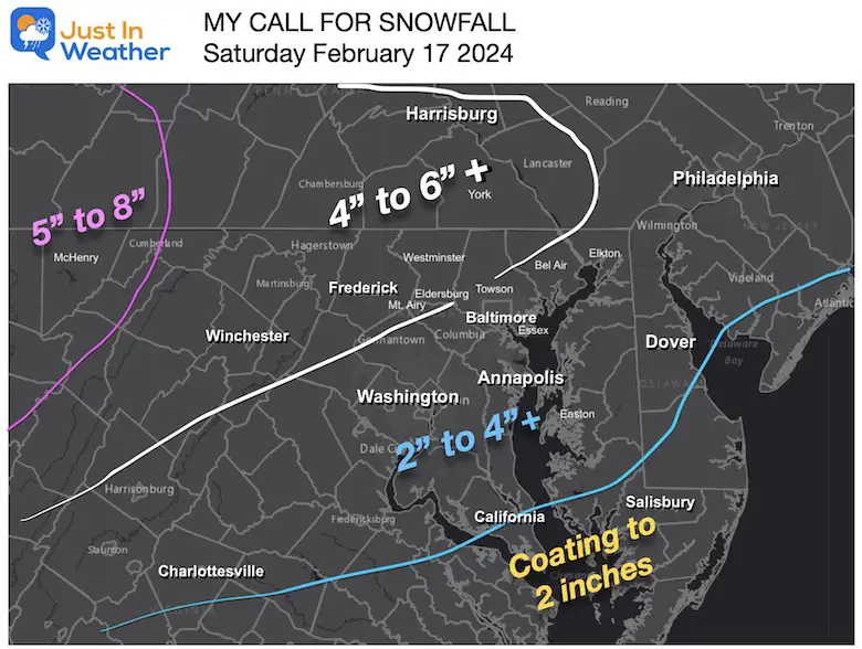
My Call For Snowfall
I did confess on my morning Facebook report that I accept my fail. While looking at my map compared with the reports above, it wasn’t too horrible. Much of my 4 to 6-inch zone fell into the 2 to 4-inch range. Far Southern Maryland also fell short due to temps remaining too warm for full stickage.
My Western Maryland snow call did work out!
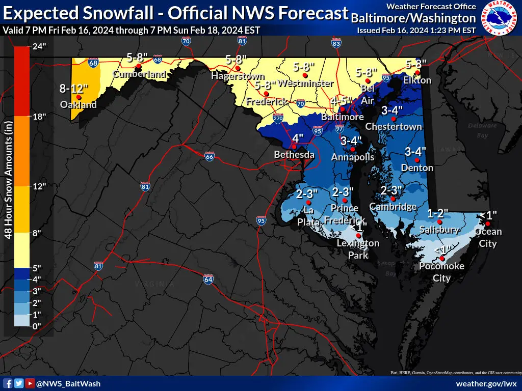
National Weather Service Final Call: Maryland
This was the map I posted Friday evening and that 5 to 8 inch range was forecast flop.
More Local Maps
Northeastern Maryland
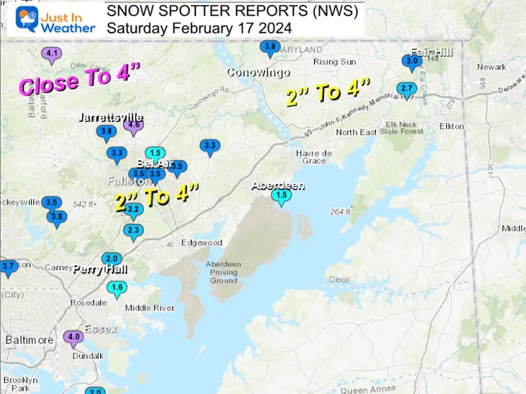
Central Maryland, North of Baltimore
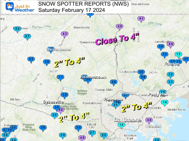
Metro Baltimore
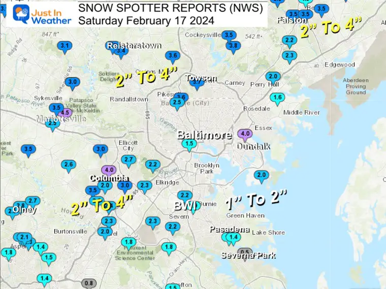
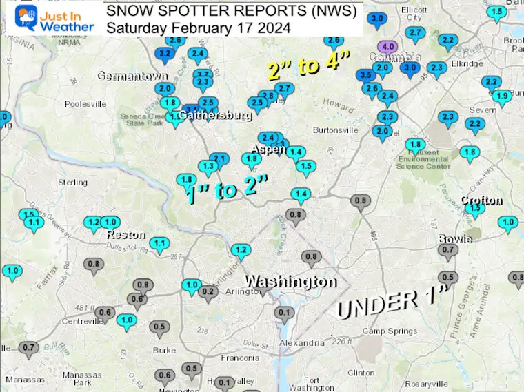
Metro Washington
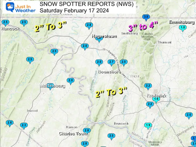
Maryland Front Ridge
Maryland High Western Mountains
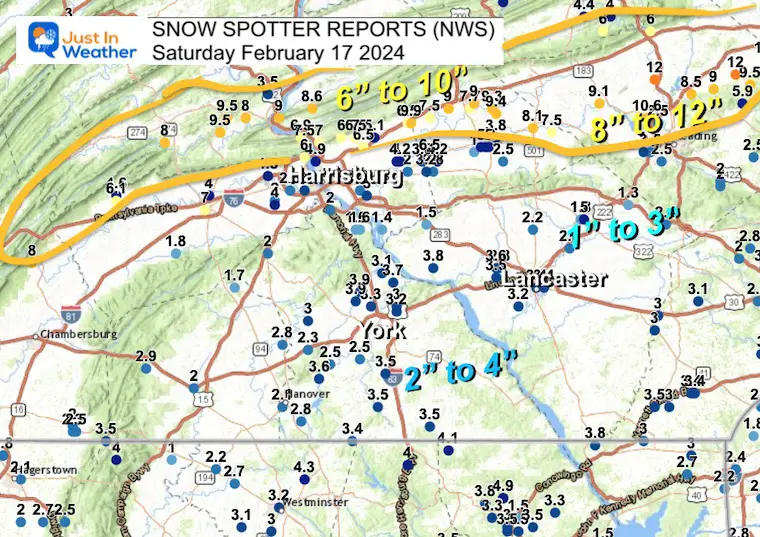
Southern Pennsylvania
I have heard the range across York County was between 1/2 inch to 4 inches.
The POWER ZONE was the band of heavy snow that set up North of Harrisburg, where 6 to 10 inches of snow fell.
Higher amounts were measured farther east along and north of I-78 towards Reading, where 8 to 12 inches fell in the storm bull’s eye.
Delaware
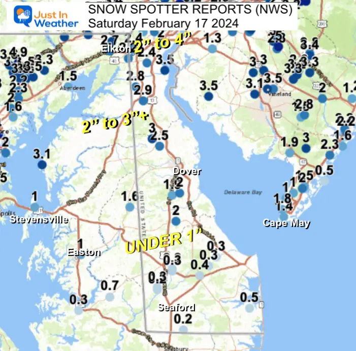
Snow Spotter List
From NWS Sterling VA Office
********************STORM TOTAL SNOWFALL********************
LOCATION TOTAL TIME/DATE COMMENTS
SNOWFALL MEASURED
(inches)
DISTRICT OF COLUMBIA
…District of Columbia…
Dalecarlia Reservoir 1.2 800 AM 2/17 Co-Op Observer
Washington 3 NE 0.8 700 AM 2/17 CoCoRaHS
MARYLAND
…Allegany County…
Frostburg 3.6 921 AM 2/17 Co-Op Observer
Bellegrove 1 SSE 3.0 803 AM 2/17 Trained Spotter
Ridgeley 1 NW 3.0 139 AM 2/17 Trained Spotter
Potomac Park 2 NW 2.6 924 AM 2/17 Dept of Highways
Cumberland 2.0 700 AM 2/17 Co-Op Observer
…Anne Arundel County…
Severn 2 W 2.3 700 AM 2/17 CoCoRaHS
BWI Airport 2.2 700 AM 2/17 Official NWS Obs
Severn 1 SSE 2.2 600 AM 2/17 CoCoRaHS
Glen Burnie 1 WSW 1.9 700 AM 2/17 Trained Spotter
Odenton 1 N 1.8 700 AM 2/17 CoCoRaHS
Laurel 4 E 1.8 700 AM 2/17 CoCoRaHS
Pasadena 1 SE 1.5 600 AM 2/17 CoCoRaHS
Crofton 1 SSE 1.5 335 AM 2/17 NWS Employee
Chelsea Beach 1.4 650 AM 2/17 Trained Spotter
Crownsville 3 SSW 1.0 600 AM 2/17 Trained Spotter
Birdsville WSW 0.8 730 AM 2/17 CoCoRaHS
Arnold 2 N 0.5 800 AM 2/17 CoCoRaHS
…Baltimore County…
Rosedale 2 S 4.0 700 AM 2/17 HADS
Bentley Springs 1 E 4.0 745 AM 2/17 Trained Spotter
Long Green 1 SW 3.8 700 AM 2/17 CoCoRaHS
Towson 1 SW 3.7 815 AM 2/17 CoCoRaHS
Brooklandville 2 NNW 3.6 514 AM 2/17 Trained Spotter
Long Green 2 NW 3.5 838 AM 2/17 Trained Spotter
Reisterstown 3.4 331 AM 2/17 Trained Spotter
Glyndon 1 SW 3.2 907 AM 2/17 Trained Spotter
Kingsville 1 E 2.3 700 AM 2/17 CoCoRaHS
Catonsville 1 SSE 2.2 815 AM 2/17 Trained Spotter
Edgemere SE 2.0 635 AM 2/17 Trained Spotter
Upper Falls 2 SW 2.0 750 AM 2/17 Trained Spotter
White Marsh 2 ESE 1.6 700 AM 2/17 CoCoRaHS
…Baltimore City…
Mount Washington 1 N 3.6 700 AM 2/17 CoCoRaHS
Pimlico SE 2.5 615 AM 2/17 Trained Spotter
Baltimore 2 SW 1.5 330 AM 2/17 Public
…Calvert County…
Huntingtown 3 NNW 0.3 700 AM 2/17 CoCoRaHS
Eagle Harbor 3 E 0.2 830 AM 2/17 CoCoRaHS
Prince Frederick 1 W 0.2 800 AM 2/17 CoCoRaHS
Prince Frederick 1 S 0.1 600 AM 2/17 Trained Spotter
…Carroll County…
Westminster 6 NE 4.3 518 AM 2/17 NWS Employee
Columbia 2 NNE 4.0 709 AM 2/17 Trained Spotter
Millers 4 NE 3.4 730 AM 2/17 Co-Op Observer
Westminster SE 3.2 820 AM 2/17 Trained Spotter
Gamber 1 WNW 3.1 900 AM 2/17 NWS Employee
Marston 2 N 3.1 700 AM 2/17 CoCoRaHS
Eldersburg 1 SE 3.0 700 AM 2/17 Trained Spotter
Westminster 3 SSW 3.0 700 AM 2/17 CoCoRaHS
Eldersburg 1 E 3.0 700 AM 2/17 CoCoRaHS
Uniontown 3 N 2.7 715 AM 2/17 Trained Spotter
Taneytown NE 2.2 850 AM 2/17 Trained Spotter
…Cecil County…
Rock Springs 1 ESE 3.8 625 AM 2/17 Trained Spotter
Fair Hill 1 SW 3.0 835 AM 2/17 Trained Spotter
Elkton 5 NW 2.7 700 AM 2/17 CoCoRaHS
…Charles County…
Bryantown 2 NE 0.3 700 AM 2/17 CoCoRaHS
Waldorf 3 S 0.3 800 AM 2/17 CoCoRaHS
…Frederick County…
Pleasant Walk 1 NNE 2.5 800 AM 2/17 Trained Spotter
Bloomfield 2 WSW 2.2 300 AM 2/17 Trained Spotter
Ballenger Creek 1 NN 2.2 750 AM 2/17 Trained Spotter
Green Valley 1 WNW 2.0 719 AM 2/17 Trained Spotter
Adamstown 1 ESE 1.9 700 AM 2/17 NWS Employee
Frederick 1 S 1.6 806 AM 2/17 CoCoRaHS
Emmitsburg 2 SE 1.0 655 AM 2/17 Co-Op Observer
…Garrett County…
Accident 4 E 6.7 1036 AM 2/17 Public
Accident 3 NNE 6.5 950 AM 2/17 Dept of Highways
Mountain Lake Park 1 6.0 953 AM 2/17 Dept of Highways
Oakland 6.0 937 AM 2/17 Dept of Highways
Grantsville 7 WNW 5.7 730 AM 2/17 Trained Spotter
Grantsville 4 E 5.5 952 AM 2/17 Dept of Highways
Grantsville 5 W 5.3 936 AM 2/17 Dept of Highways
Deer Park 4 NNE 5.1 700 AM 2/17 Trained Spotter
Barton 4.8 928 AM 2/17 Public
Mc Henry 4 SE 4.0 929 AM 2/17 Park/Forest Srvc
…Harford County…
Forest Hill 1 NNW 4.9 700 AM 2/17 Trained Spotter
Chrome Hill 2 SE 4.6 434 AM 2/17 Trained Spotter
Norrisville 1 WSW 4.1 650 AM 2/17 CoCoRaHS
Jarrettsville 2 ESE 3.8 600 AM 2/17 CoCoRaHS
Bel Air 2 E 3.5 830 AM 2/17 Trained Spotter
Bel Air 2 W 3.5 715 AM 2/17 Trained Spotter
Bel Air 3.5 820 AM 2/17 Public
Forest Hill 3 SW 3.3 750 AM 2/17 Trained Spotter
Churchville 1 N 3.3 357 AM 2/17 Trained Spotter
Kingsville 3 NNE 2.2 700 AM 2/17 CoCoRaHS
Bynum 1 E 1.5 810 AM 2/17 Trained Spotter
Aberdeen Proving Gro 1.5 407 AM 2/17 Trained Spotter
…Howard County…
Sykesville 3 SE 4.5 700 AM 2/17 CoCoRaHS
Glenwood 1 SSW 3.5 700 AM 2/17 CoCoRaHS
Simpsonville E 3.5 930 AM 2/17 Trained Spotter
Sykesville 2 SSE 3.5 700 AM 2/17 CoCoRaHS
Ellicott City 1 WSW 3.0 740 AM 2/17 CoCoRaHS
Elkridge 2 W 3.0 545 AM 2/17 Trained Spotter
Ilchester 1 W 2.7 815 AM 2/17 Trained Spotter
Clarksville 2 N 2.6 500 AM 2/17 Trained Spotter
Simpsonville 1 SSE 2.6 358 AM 2/17 Trained Spotter
West Friendship 2 NW 2.5 1026 AM 2/17 Trained Spotter
Columbia 3 SSE 2.4 700 AM 2/17 CoCoRaHS
Laurel 3 NNE 2.3 601 AM 2/17 Trained Spotter
Elkridge 2.3 830 AM 2/17 NWS Employee
North Laurel 2 ESE 2.3 700 AM 2/17 CoCoRaHS
Laurel 1 NNE 2.0 600 AM 2/17 CoCoRaHS
Columbia 2.0 600 AM 2/17 NWS Employee
…Montgomery County…
Damascus 1 SE 3.2 700 AM 2/17 Trained Spotter
Clarksburg 2 SE 3.2 814 AM 2/17 Trained Spotter
Laytonsville 5 NNW 3.2 700 AM 2/17 CoCoRaHS
Gaithersburg 1 ESE 3.1 757 AM 2/17 Public
Damascus 3 SSW 3.1 800 AM 2/17 Co-Op Observer
Damascus 1 S 3.0 741 AM 2/17 Trained Spotter
Olney 1 ENE 2.8 640 AM 2/17 CoCoRaHS
Gaithersburg 2 E 2.8 700 AM 2/17 CoCoRaHS
Ashton-Sandy Springs 2.7 700 AM 2/17 CoCoRaHS
Montgomery Village 1 2.7 630 AM 2/17 CoCoRaHS
Germantown 5 NNE 2.6 600 AM 2/17 CoCoRaHS
Olney 2.5 840 AM 2/17 Trained Spotter
Washington Grove 1 N 2.5 956 AM 2/17 Trained Spotter
Laytonsville 2 WNW 2.4 700 AM 2/17 Trained Spotter
Norbeck 1 ESE 2.4 700 AM 2/17 CoCoRaHS
Gaithersburg 3 NE 2.3 700 AM 2/17 CoCoRaHS
Colesville 2 W 2.3 700 AM 2/17 CoCoRaHS
Rockville 1 SSE 2.1 845 AM 2/17 Trained Spotter
Rossmoor 1 ESE 2.1 700 AM 2/17 CoCoRaHS
Germantown 1 SE 2.0 908 AM 2/17 Trained Spotter
Gaithersburg 1 SW 1.9 440 AM 2/17 Trained Spotter
Rockville 3 E 1.8 700 AM 2/17 CoCoRaHS
North Potomac 4 N 1.8 700 AM 2/17 CoCoRaHS
Potomac 1 NNW 1.8 700 AM 2/17 CoCoRaHS
White Oak 1 N 1.5 700 AM 2/17 CoCoRaHS
Four Corners 1 ESE 1.4 738 AM 2/17 Trained Spotter
Silver Spring 6 NNE 1.4 455 AM 2/17 CoCoRaHS
Potomac 3 NE 1.3 700 AM 2/17 CoCoRaHS
Takoma Park 1 NNW 0.8 700 AM 2/17 CoCoRaHS
…Prince Georges County…
Greenbelt 1 N 0.8 915 AM 2/17 CoCoRaHS
Bowie 2 SSE 0.7 815 AM 2/17 NWS Employee
Bowie 4 S 0.5 700 AM 2/17 CoCoRaHS
Fort Washington 1 SS 0.5 700 AM 2/17 CoCoRaHS
…Washington County…
Sabillasville 2 NNW 3.5 742 AM 2/17 CoCoRaHS
Maugansville WSW 2.8 700 AM 2/17 Trained Spotter
Hagerstown 4 NNW 2.8 700 AM 2/17 CoCoRaHS
Boonsboro 3 NNE 2.7 600 AM 2/17 Trained Spotter
Pecktonville 3 NNW 2.5 630 AM 2/17 NWS Employee
Hancock 1 ESE 2.5 700 AM 2/17 Trained Spotter
Hagerstown 1 ENE 2.1 700 AM 2/17 CoCoRaHS
Williamsport 3 ENE 2.0 600 AM 2/17 CoCoRaHS
Fairplay 3 ENE 2.0 700 AM 2/17 Trained Spotter
VIRGINIA
…Arlington County…
Reagan National Apt 0.1 700 AM 2/17 Official NWS Obs
Rosslyn 1 S 0.1 330 AM 2/17 Trained Spotter
…City of Fairfax…
Fairfax 1 N 0.6 700 AM 2/17 CoCoRaHS
…Clarke County…
Berryville 1 NNW 2.5 605 AM 2/17 Trained Spotter
…Culpeper County…
Reva 1 SSE 1.3 800 AM 2/17 CoCoRaHS
Rixeyville 3 N 1.0 700 AM 2/17 CoCoRaHS
Cardova 2 NW 0.8 730 AM 2/17 Trained Spotter
…Fairfax County…
Herndon 1 NNE 1.2 255 AM 2/17 Trained Spotter
Herndon 2 ENE 1.1 850 AM 2/17 Trained Spotter
Vienna 3 N 1.1 700 AM 2/17 CoCoRaHS
Falls Church 2 W 1.0 700 AM 2/17 CoCoRaHS
Fairfax 1 SW 1.0 322 AM 2/17 Trained Spotter
Reston 2 N 1.0 700 AM 2/17 CoCoRaHS
Oakton E 0.9 800 AM 2/17 CoCoRaHS
Vienna 0.8 700 AM 2/17 Co-Op Observer
Herndon 3 S 0.8 700 AM 2/17 CoCoRaHS
Fairfax 3 W 0.6 700 AM 2/17 CoCoRaHS
West Springfield 2 W 0.6 745 AM 2/17 Trained Spotter
Mantua 1 S 0.5 800 AM 2/17 CoCoRaHS
Springfield 2 SW 0.5 700 AM 2/17 CoCoRaHS
Falls Church SE 0.2 730 AM 2/17 Trained Spotter
Alexandria 6 SSW 0.2 700 AM 2/17 CoCoRaHS
Franconia 1 SSE 0.1 700 AM 2/17 CoCoRaHS
…Fauquier County…
Marshall 8 SW 1.0 700 AM 2/17 CoCoRaHS
Broad Run 3 SSW 1.0 700 AM 2/17 CoCoRaHS
Warrenton 3 SE 0.9 700 AM 2/17 CoCoRaHS
…Frederick County…
Cedar Hill 4 NNW 2.6 731 AM 2/17 Trained Spotter
Winchester 3 NE 1.5 713 AM 2/17 Trained Spotter
Stephens City 2 E 1.0 200 AM 2/17 Trained Spotter
…Highland County…
Hightown 5 NW 7.5 1040 AM 2/17 Public
Monterey 1 SW 2.3 540 AM 2/17 CoCoRaHS
Mill Gap 1 SW 0.8 600 AM 2/17 Co-Op Observer
Monterey 7 SSW 0.5 700 AM 2/17 CoCoRaHS
…Loudoun County…
Bloomery 3 ESE 2.8 630 AM 2/17 Trained Spotter
Lovettsville 2.5 510 AM 2/17 NWS Employee
Leesburg 2 NNE 2.0 854 AM 2/17 CoCoRaHS
Hillsboro 3 NE 2.0 923 AM 2/17 Trained Spotter
Round Hill 3 WSW 1.9 900 AM 2/17 CoCoRaHS
Purcellville 1.8 830 AM 2/17 Co-Op Observer
Purcellville 2 NNE 1.8 915 AM 2/17 Trained Spotter
Arcola 3 NNE 1.5 253 AM 2/17 NWS Employee
Dulles International 1.1 700 AM 2/17 Official NWS Obs
Arcola 3 S 1.0 316 AM 2/17 Trained Spotter
Arcola 1 WNW 1.0 700 AM 2/17 CoCoRaHS
…Madison County…
Madison 7 NNW 0.7 700 AM 2/17 CoCoRaHS
…Page County…
Honeyville 1 ESE 1.2 630 AM 2/17 Trained Spotter
…Prince William County…
Woolsey 1 SW 1.2 645 AM 2/17 Trained Spotter
Independent Hill 3 N 1.1 514 AM 2/17 Trained Spotter
Manassas 5 SE 1.1 600 AM 2/17 CoCoRaHS
Manassas 6 SE 1.0 530 AM 2/17 CoCoRaHS
Manassas 3 NNW 0.7 700 AM 2/17 CoCoRaHS
Dale City 1 W 0.3 930 AM 2/17 Trained Spotter
…Rappahannock County…
Sperryville 1.1 500 AM 2/17 Co-Op Observer
…Rockingham County…
Elkton 0.6 818 AM 2/17 Trained Spotter
Harrisonburg 4 SE 0.1 800 AM 2/17 CoCoRaHS
…Shenandoah County…
Edinburg 2 E 1.5 645 AM 2/17 Trained Spotter
Strasburg 4 N 1.2 700 AM 2/17 CoCoRaHS
Alonzaville 2 ENE 0.8 850 AM 2/17 Trained Spotter
…Stafford County…
Stafford 6 WNW 0.3 700 AM 2/17 CoCoRaHS
Ramoth 1 W T 700 AM 2/17 Trained Spotter
…Warren County…
Karo 1 WSW 1.5 700 AM 2/17 Trained Spotter
WEST VIRGINIA
…Berkeley County…
Johnsontown 1 S 2.5 742 AM 2/17 Trained Spotter
Falling Waters 2 NW 2.5 225 AM 2/17 Trained Spotter
Martinsburg 2 E 2.3 827 AM 2/17 NWS Employee
Bunker Hill 2 SW 2.3 635 AM 2/17 CoCoRaHS
Shepherdstown 4 NNW 2.0 800 AM 2/17 Trained Spotter
…Grant County…
Mount Storm 7.0 1026 AM 2/17 Dept of Highways
Bayard 5.5 700 AM 2/17 Co-Op Observer
Jordan Run 3.0 1025 AM 2/17 Public
…Hampshire County…
Romney 1 SW 3.0 700 AM 2/17 Co-Op Observer
…Hardy County…
Rig NW 4.2 800 AM 2/17 CoCoRaHS
McNeill 3 NNW 4.0 657 AM 2/17 Trained Spotter
…Jefferson County…
Millville 1 ESE 2.8 720 AM 2/17 Trained Spotter
Bloomery 3 SSE 1.8 648 AM 2/17 Trained Spotter
Harpers Ferry 13 SSW 1.5 700 AM 2/17 CoCoRaHS
…Mineral County…
Keyser 5.0 203 AM 2/17 Trained Spotter
Russelldale 3 NNE 4.5 1022 AM 2/17 Dept of Highways
Burlington E 3.4 830 AM 2/17 Trained Spotter
Keyser 2 SSW 3.2 700 AM 2/17 Co-Op Observer
…Pendleton County…
Deer Run 2 WSW 4.0 1027 AM 2/17 Trained Spotter
Fort Seybert 3 NE 2.6 600 AM 2/17 CoCoRaHS
Recent Snow Reports
February 13 Snow Report Maps
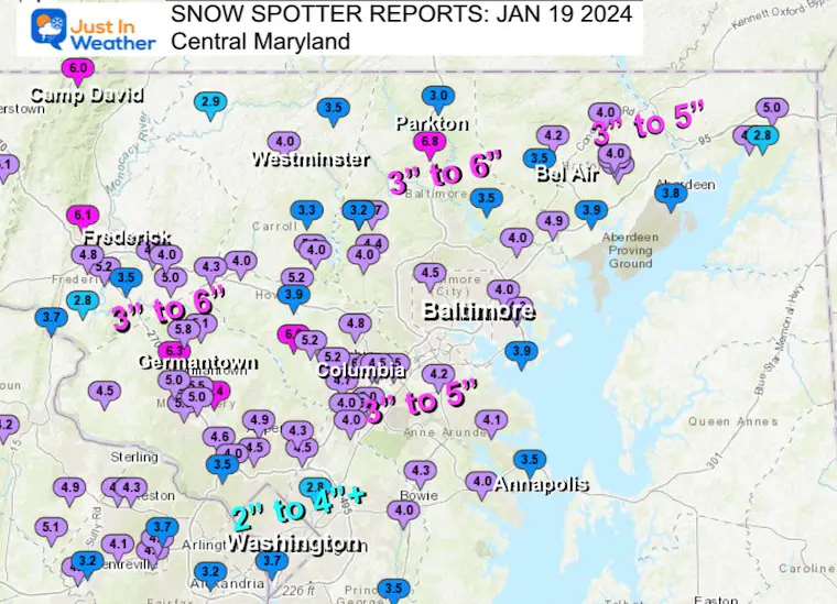
January 19 Recap
Click here for the maps and full report
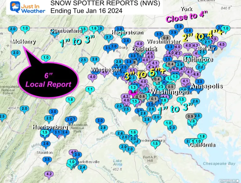
Jan 16 Snow Report
Click here or the map to see: The Snow Report Ending Jan 16
Subscribe for eMail Alerts
Weather posts straight to your inbox
Sign up and be the first to know!
Explore More
Maryland Snow Climate History And Other Winter Pages
STEM Assemblies/In School Fields Trips Are Back
Click to see more and ‘Book’ a visit to your school
RECENT Winter Outlook Reports:
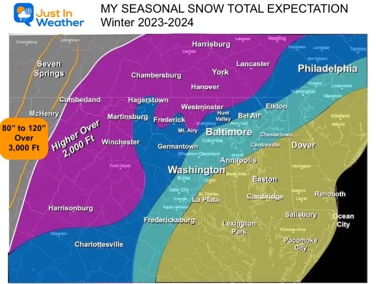
My Winter Outlook: More Snow
Faith in the Flakes Gear
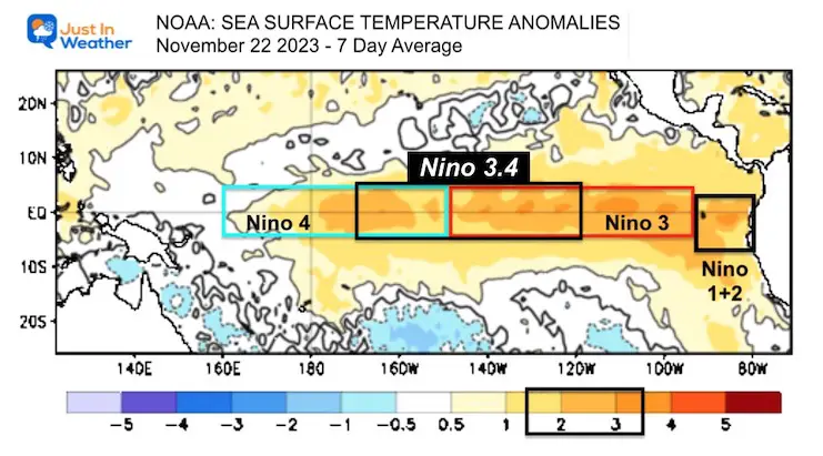
El Niño Winter Updates
Late November: Warm Water Shifts West In Pacific Could Mean More Snow For Eastern US
Computer Models Support East Coast Storm Track
The latest NOAA report is confident in a Very Strong event. Possibly HISTORIC! This refers to the temperatures in the Pacific, with impacts on the US Winter Storm Track.
Winter Weather Folklore: Top 20 and more signals from nature for snow.
Winter Outlook 2024 From Two Farmers Almanacs Return to Cold and Snow
Please share your thoughts and best weather pics/videos, or just keep in touch via social media
-
Facebook: Justin Berk, Meteorologist
-
Twitter
-
Instagram
RESTATING MY MESSAGE ABOUT DYSLEXIA
I am aware there are some spelling and grammar typos and occasional other glitches. I take responsibility for my mistakes and even the computer glitches I may miss. I have made a few public statements over the years, but if you are new here, you may have missed it: I have dyslexia and found out during my second year at Cornell University. It didn’t stop me from getting my meteorology degree and being the first to get the AMS CBM in the Baltimore/Washington region. One of my professors told me that I had made it that far without knowing and to not let it be a crutch going forward. That was Mark Wysocki, and he was absolutely correct! I do miss my mistakes in my own proofreading. The autocorrect spell check on my computer sometimes does an injustice to make it worse. I also can make mistakes in forecasting. No one is perfect at predicting the future. All of the maps and information are accurate. The ‘wordy’ stuff can get sticky. There has been no editor who can check my work when I need it and have it ready to send out in a newsworthy timeline. Barbara Werner is a member of the web team that helps me maintain this site. She has taken it upon herself to edit typos when she is available. That could be AFTER you read this. I accept this and perhaps proves what you read is really from me… It’s part of my charm. #FITF


