


May 11 Aurora Viewing Forecast Weather And More Photos
Saturday May 11, 2024 The display of Northern Lights last night was historic. As the name implies, this is more common in the Northern Latitudes. On rare occasions we can…
Friday Afternoon, January 19 2024
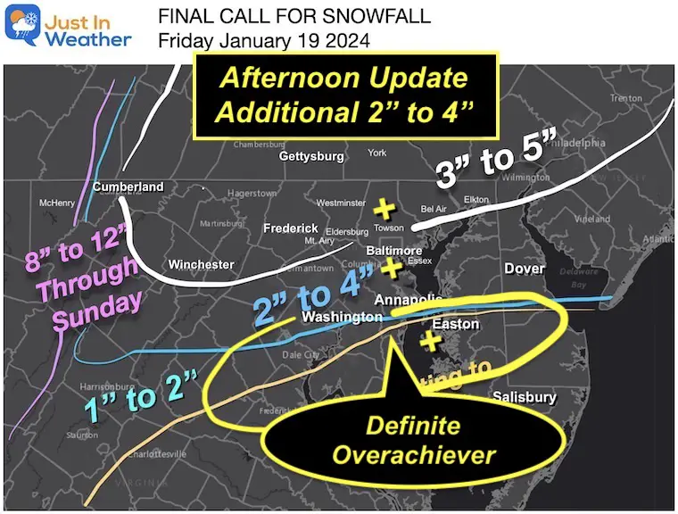
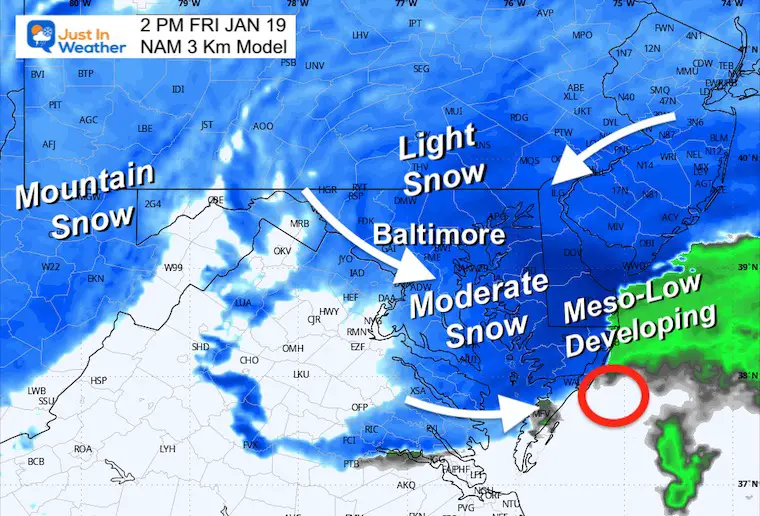
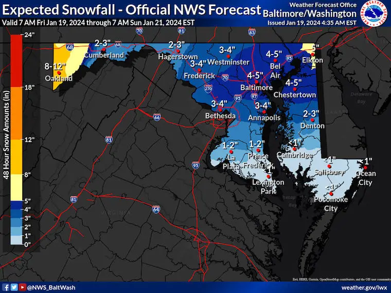
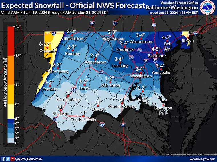
Without a doubt, we have an overachiever on our hands. I hope my updates yesterday and this morning helped you anticipate the ramping up of snow expectations. It still was not enough to account for the burst this morning.
If the snow stopped now (1 PM), I would hit my call or just under in most areas. There will be additional accumulation. Much of central Maryland seems to be close to 4 inches as of noon, and there is more to go. If you have been watching the radar expecting the back edge to swing through, perhaps you noticed it filled back in and enhanced. This next surge will favor the lower half of Maryland where it remains at or below freezing: West of Salisbury.
Also, the snow did bust on the high side for our southern areas. There is more on the way over the next few hours.
Let’s take a look in this brief report.
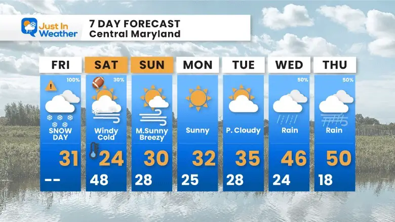
Reminder: The Ravens Game is going to be COLD! Another look at those conditions expected below.
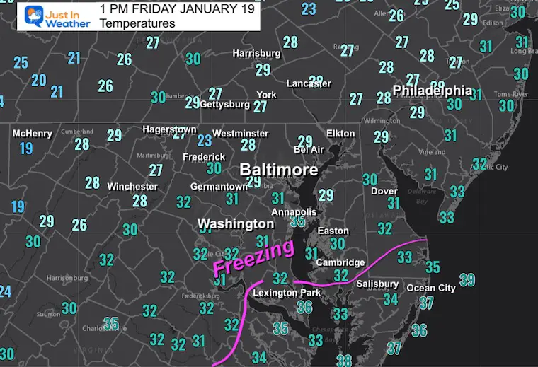
The moderate snow intensity has helped maintain the freezing temperatures into Southern Maryland. The melting line appears to be in St. Mary’s County and from Salisbury to the beaches.
I did increase my call last night and beafed this map up a lot today, trying to highlight the additional snow.
This afternoon may bring another 2 to 4 inches in parts of central and Southern Maryland.
1 to 2 inches of new snow on the north side… all will stick with the colder air.
I made a request on Facebook… Here was the response. Many areas in central Maryland were close to 4 inches… with more on the way. Click to view (it might take you offsite to FB or your app).
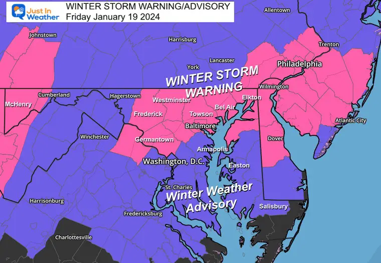
Some counties on Delmarva might qualify for the upgrade to a Warning (Queen Annes, Talbot, Caroline), but that is not my call.
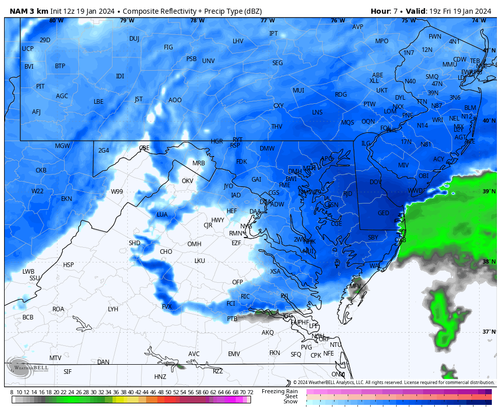
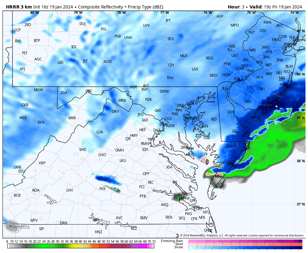
This is NOT in winter mode, but may help show the intensity better.
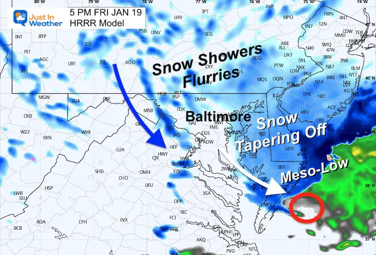
If you see a back edge approaching, that is NOT the end. It will redevelop, as we will see on the forecast simulation below.
The primary Low is well off the coast, far from the snow burst. The upper-level energy I mentioned is working on a new smaller circulation near lower Delmarva. This is the Meso-Low I keep mentioning.
This is the enhancement for the snow we are now seeing resurge.
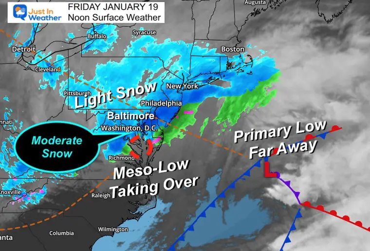
I’ve highlighted where I see the Meso-Low and the circulation enhancing the snowfall for a few hours.
This will taper off by evening, with some snow showers and isolated bands up to midnight. There may be another coating tonight.
This solution has that Meso-Low nearly stalled for a few hours… but the snow intensity will fade quickly later in the day and evening to snow showers and flurries.
It will be a cold and windy day!
The mountains will continue to get snow, and a few flurries may reach central Maryland.
The Ravens Game will be very cold! I am going with my son, and I will have my snowboarding gear on!
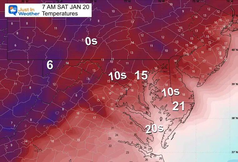
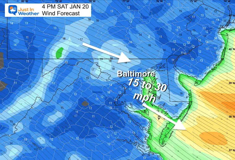
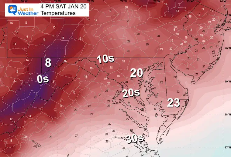
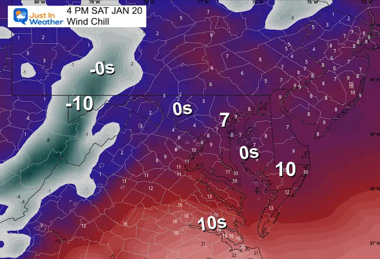
After this snow event, wind and cold will hold all weekend.
Strong winds and even flurries on Saturday.
The next storm will track west. This will bring in warmer air and rain on Wednesday and Thursday.


Click to see more and ‘Book’ a visit to your school 


Computer Models Support East Coast Storm Track

The latest NOAA report is confident in a Very Strong event. Possibly HISTORIC! This refers to the temperatures in the Pacific, with impacts on the US Winter Storm Track.

Winter Weather Folklore: Top 20 and more signals from nature for snow.
Winter Outlook 2024 From Two Farmers Almanacs Return to Cold and Snow
I am aware there are some spelling and grammar typos and occasional other glitches. I take responsibility for my mistakes and even the computer glitches I may miss. I have made a few public statements over the years, but if you are new here, you may have missed it: I have dyslexia and found out during my second year at Cornell University. It didn’t stop me from getting my meteorology degree and being the first to get the AMS CBM in the Baltimore/Washington region. One of my professors told me that I had made it that far without knowing and to not let it be a crutch going forward. That was Mark Wysocki, and he was absolutely correct! I do miss my mistakes in my own proofreading. The autocorrect spell check on my computer sometimes does an injustice to make it worse. I also can make mistakes in forecasting. No one is perfect at predicting the future. All of the maps and information are accurate. The ‘wordy’ stuff can get sticky. There has been no editor who can check my work when I need it and have it ready to send out in a newsworthy timeline. Barbara Werner is a member of the web team that helps me maintain this site. She has taken it upon herself to edit typos when she is available. That could be AFTER you read this. I accept this and perhaps proves what you read is really from me… It’s part of my charm. #FITF