Sunday, January 14, 2024
The once on then off again snow event is back on. With the arctic air arriving today, the strong flow in the jet stream can build up snow with less organization at the surface. In this case, the trend has split the energy too far away, now bringing it back to develop starting on Monday.
I have noticed the tendency for systems to continue to trend farther west/north when they verify. That is what happened to us last weekend.
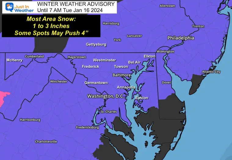
In this case, light snow may develop on Monday, especially in Southern Maryland. The main event still looks like Monday night into Tuesday. With the arctic air and likely stickage, we may not only break the snow drought for Baltimore and many other cities in central Maryland/Mid-Atlantic… but may also need to address school and work impacts.
MONDAY MORNING UPDATE
WINTER WEATHER ADVISORY
Click the image to see the NEW REPORT
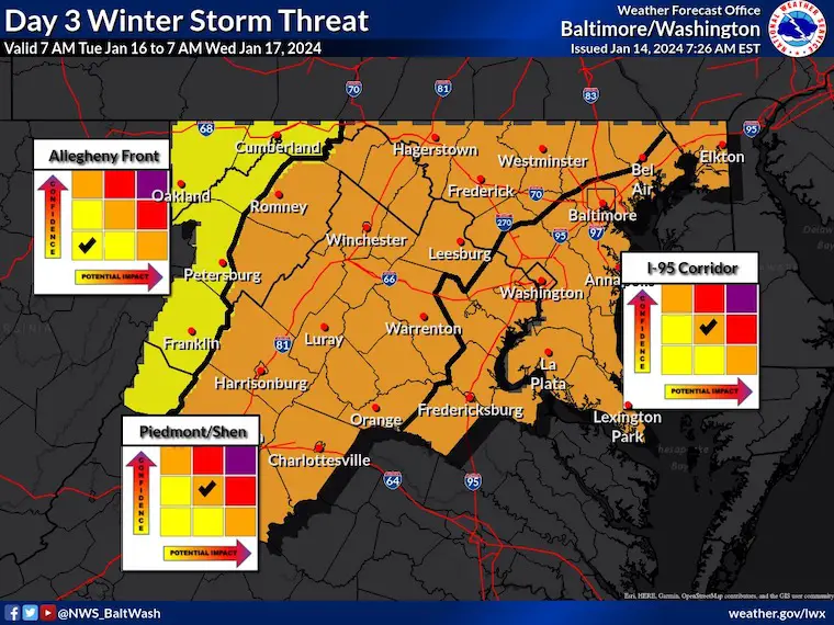
Winter Weather Impact From NWS
We have a MODERATE expectation for impact snow on Tuesday morning.
There may be a Winter Weather Advisory issued this evening. If not today, then look for a Special Weather Statement. The Advisories should be up by early tomorrow morning, given the timing of the event.
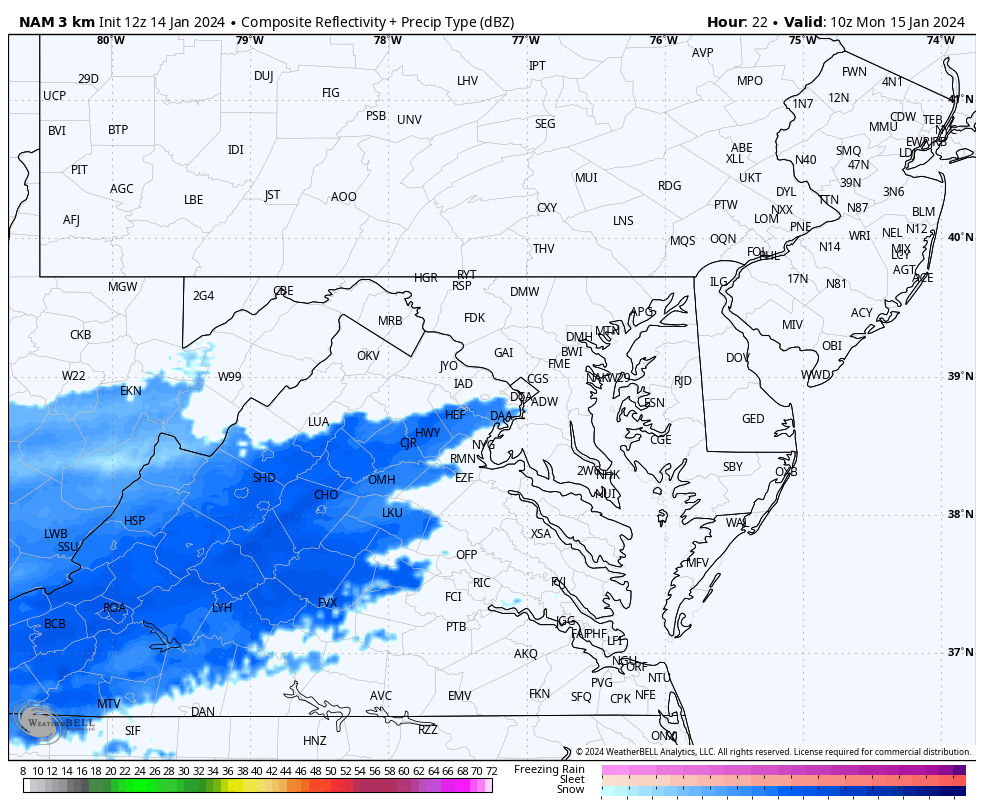
Monday Radar Simulation
NAM 3 Km 6 AM to 8 PM
This shows the morning snow to the south, then enhancing over central Maryland in the evening. I am not sold on this part so soon, but wanted to show you for posterity and discussion.
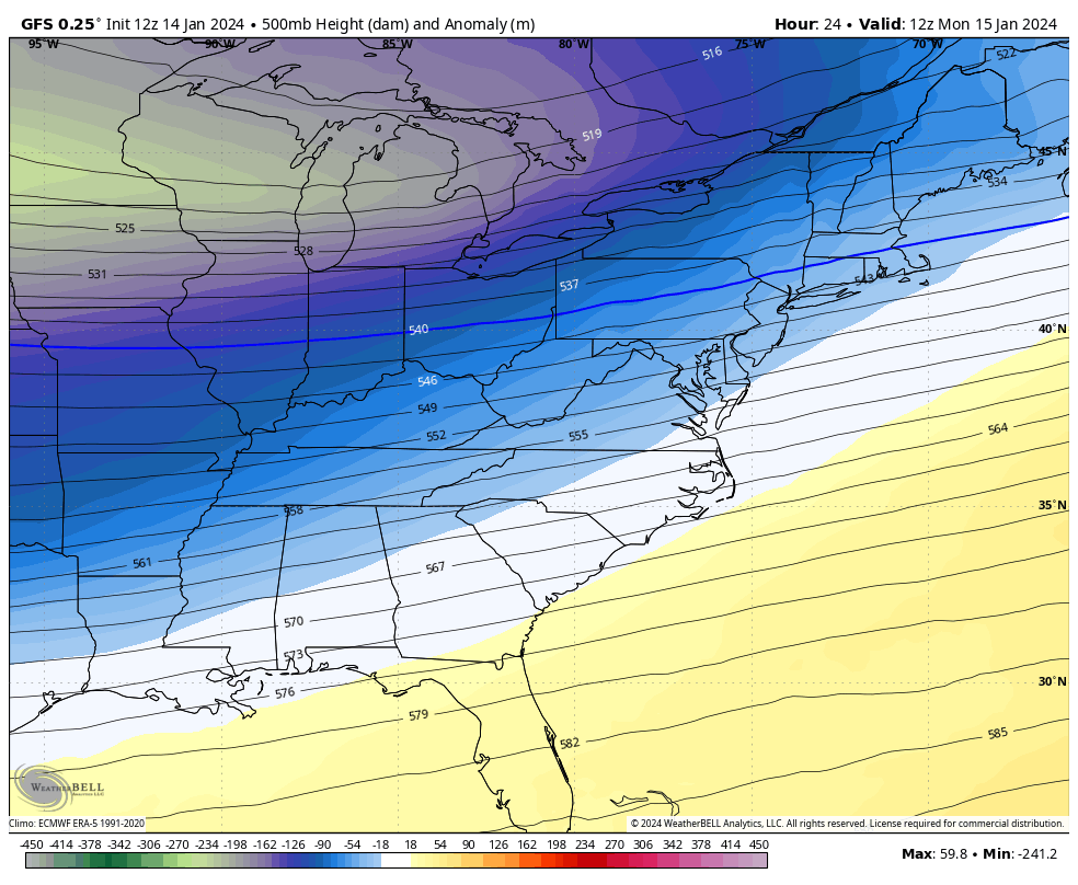
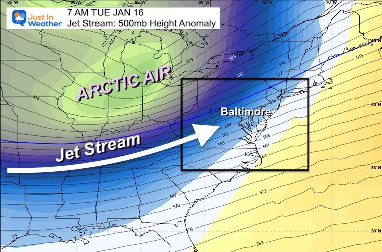
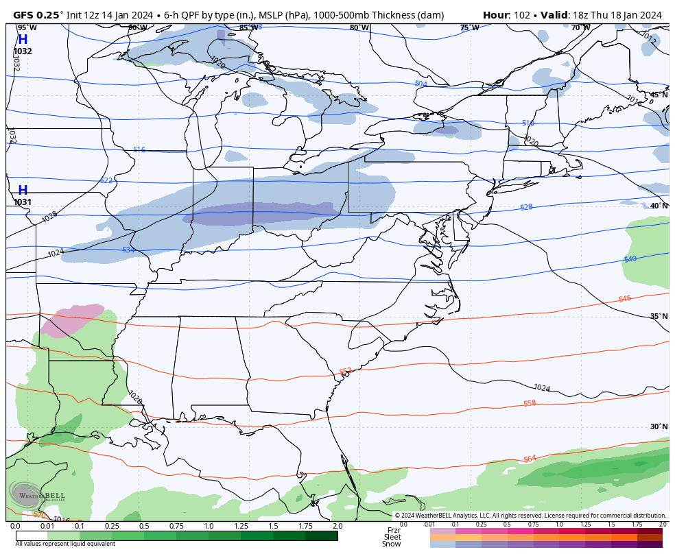
Jet Stream: Monday Morning to Saturday Morning
Here is the influence of the upper-level airflow, bringing the arctic air in with reinforcements all week.
A second potential snow event may reach us on Friday.
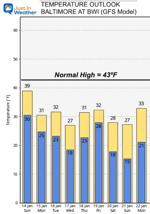
Temperature Outlook
It is going to be cold enough… Especially in the urban center of Baltimore.
Storm Set Up: Tuesday Morning
I want to take us to prime time for the event.
Jet Stream
The core of the Arctic Air (below zero) will be in the Midwest. This is the driving force for the jet stream that will flow from Southwest across our region.
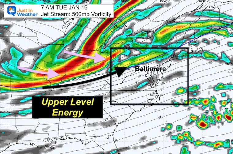
Vorticity (Spin)
500mb = 18,000 Ft
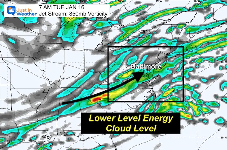
Vorticity (Spin)
500mb = 5,000 Ft
The lower level moisture will, at cloud level be lining up with the snow streak we can see translated below.
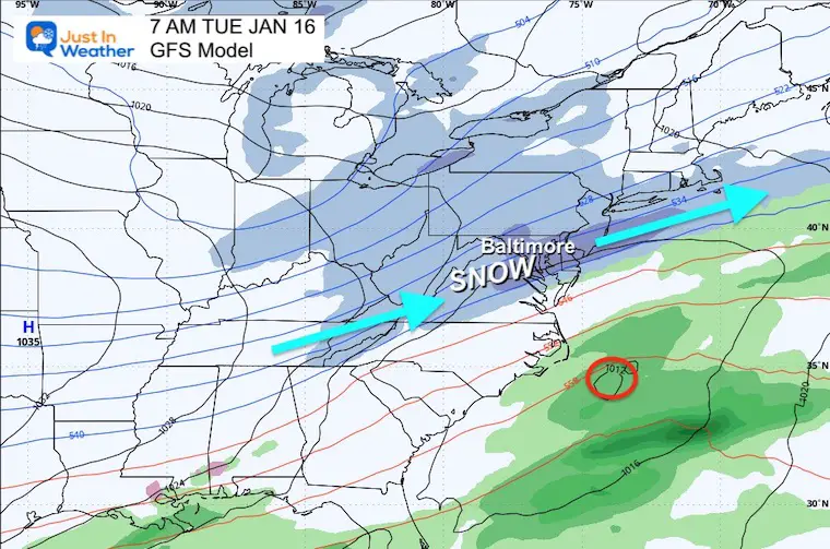
Surface Weather
The location of this band of moderate snow will be correlated to the wind flow above. Since the Surface Low is not well defined and well off the coast, this is the driving force above.
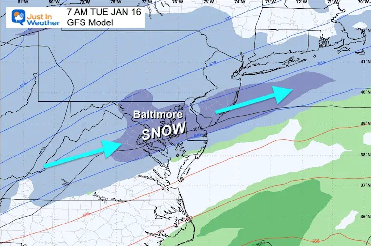
Snapshots: Close Up
GFS Model
Tuesday Morning
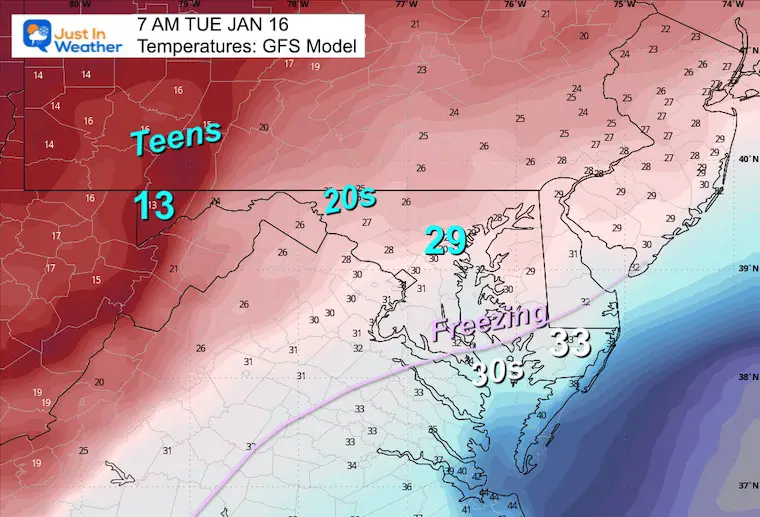
Temperatures
It will be cold enough for stickage across most of the region. Southern Maryland may be a question mark with road temps (wet or white).
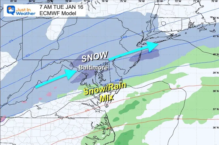
ECMWF Model
Tuesday Morning
Snowfall Potential
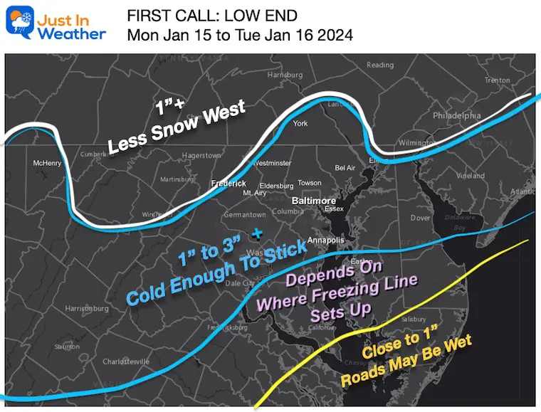
My First Call:
A conservative LOW-END approach. I include the tendency for models to overplay snow PLUS, in this case, some potential snow may get lost to Virga at the onset.
You will see some higher numbers on the other maps… I would rather ramp up with confidence as we get closer than have to pull back.
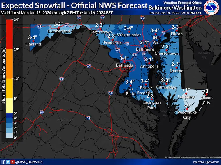
National Weather Service
I was actually surprised they went on the higher side.
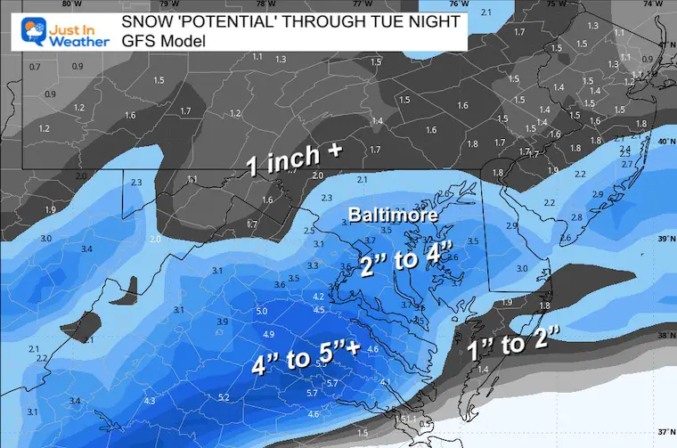
GFS Model: POTENTIAL
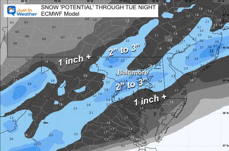
ECMWF Model: POTENTIAL
This tracks a little farther north… and does not develop the energy as much. It also introduces some rain or mix in southern Maryland.
Note: This model did the best job last weekend.
End of Week: Another Storm?
To be honest, I have low confidence in the modeling for two reasons:
- It has been poor
- We always need to see how the storm in front behaves for the atmospheric setup that follows.
We do tend to get into patterns with arctic air masses that follow this trend. So that is why I am showing it here. There is a tendency for the system to trend closer or (Northwest) of what we see plotted here… which may introduce a rain/mix line. Stay tuned. FITF
Thursday Afternoon to Saturday Evening: GFS Model
Subscribe for eMail Alerts
RECENT Winter Outlook Reports:

El Niño Winter Updates

Computer Models Support East Coast Storm Track

El Niño Advisory
The latest NOAA report is confident in a Very Strong event. Possibly HISTORIC! This refers to the temperatures in the Pacific, with impacts on the US Winter Storm Track.

Winter Weather Folklore: Top 20 and more signals from nature for snow.
NOAA’s Winter Outlook 2024
Winter Outlook 2024 From Two Farmers Almanacs Return to Cold and Snow
Explore More
Maryland Snow Climate History And Other Winter Pages

Faith in the Flakes Gear

STEM Assemblies/In School Fields Trips Are Back
Click to see more and ‘Book’ a visit to your school

Please share your thoughts and best weather pics/videos, or just keep in touch via social media
RESTATING MY MESSAGE ABOUT DYSLEXIA
I am aware there are some spelling and grammar typos and occasional other glitches. I take responsibility for my mistakes and even the computer glitches I may miss. I have made a few public statements over the years, but if you are new here, you may have missed it: I have dyslexia and found out during my second year at Cornell University. It didn’t stop me from getting my meteorology degree and being the first to get the AMS CBM in the Baltimore/Washington region. One of my professors told me that I had made it that far without knowing and to not let it be a crutch going forward. That was Mark Wysocki, and he was absolutely correct! I do miss my mistakes in my own proofreading. The autocorrect spell check on my computer sometimes does an injustice to make it worse. I also can make mistakes in forecasting. No one is perfect at predicting the future. All of the maps and information are accurate. The ‘wordy’ stuff can get sticky. There has been no editor who can check my work when I need it and have it ready to send out in a newsworthy timeline. Barbara Werner is a member of the web team that helps me maintain this site. She has taken it upon herself to edit typos when she is available. That could be AFTER you read this. I accept this and perhaps proves what you read is really from me… It’s part of my charm.
#FITF


