January 8, 2024
Monday Morning Update
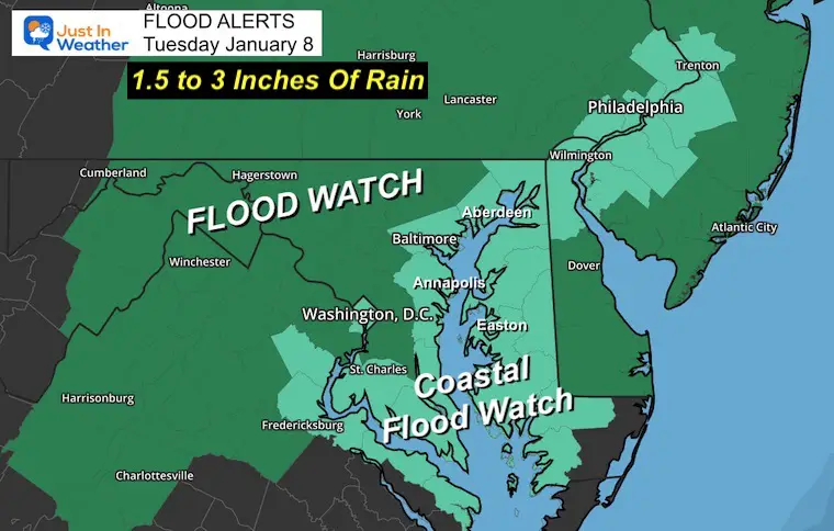
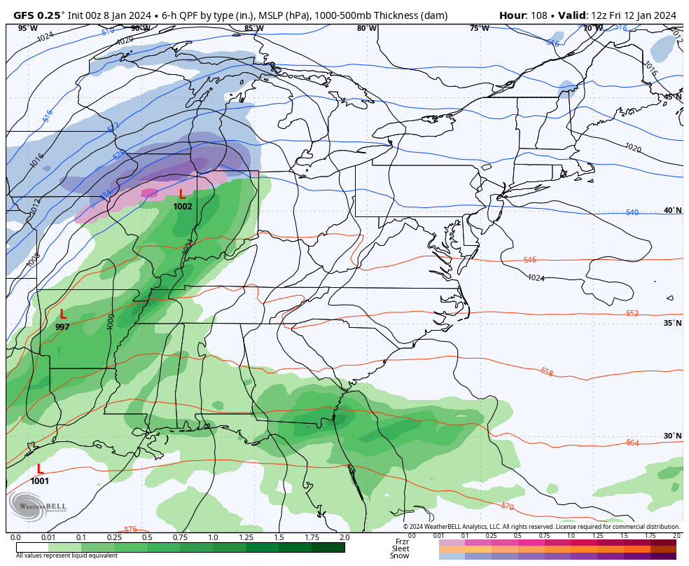
This is not the winter we expected (so far), but it is about to get more turbulent. The inland areas that had snow over the weekend will have it washed away as the next storm is going to bring very heavy rain. A Flood Watch has been issued for most of the region to receive over 1.5 inches, with some spots pushing the 3-inch mark. I guess the drought may be over!
Flood Watch
More Storm Maps Below
There will be flooding from high water in the Chesapeake Bay as strong winds will be developing from the South. There have been High Wind Watches posted, and more will be added today. If you are traveling on Tuesday, consider the impacts with restrictions likely on bridges and flight delays or cancellations. The storm will cover a large area.
Sadly, this storm pattern may repeat Friday night into Saturday.
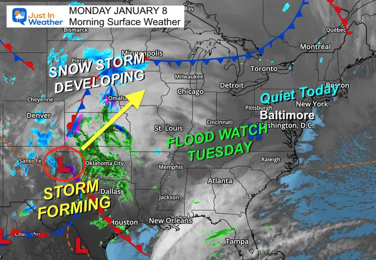
Morning Surface Weather
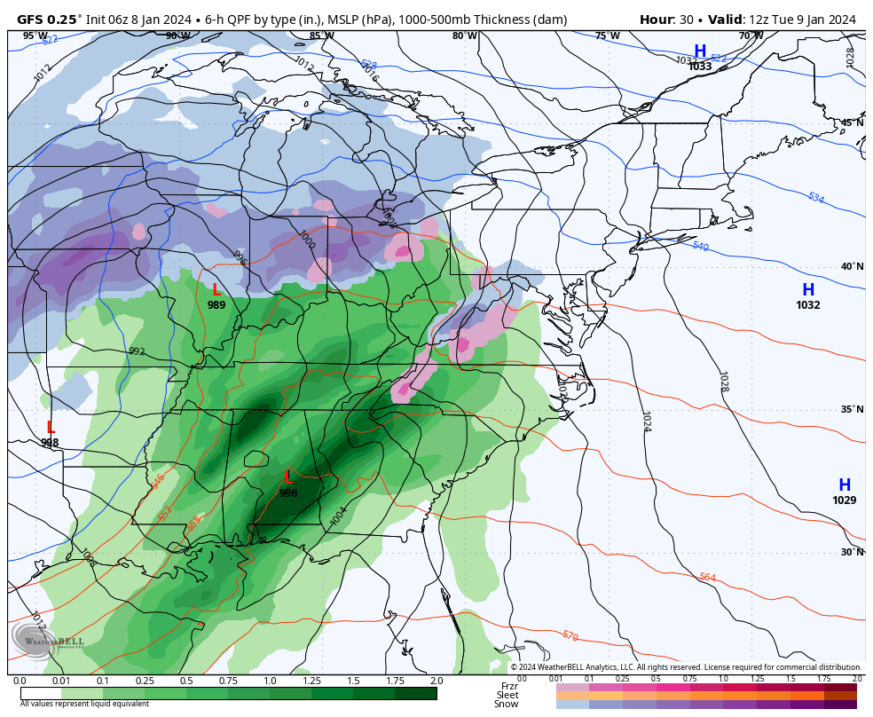
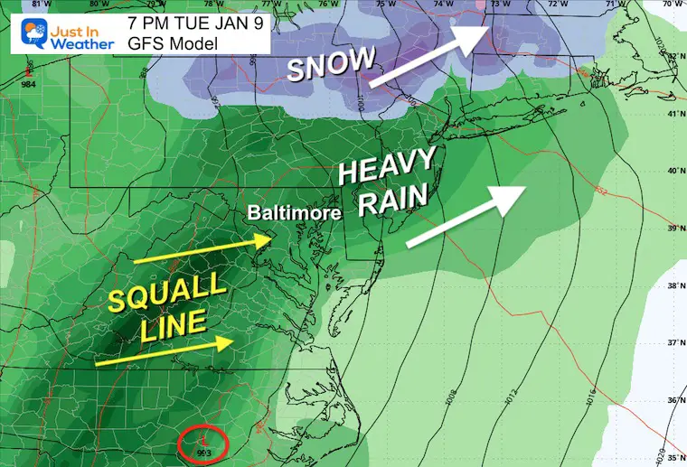
We will have a nice and seasonably cool day. The Storm is developing across North Texas and will take a track to the western Great Lakes. It will be a major snow event for the Northern Plains, but on the east side, it will pull up warm and very unstable air. That is why we expect flooding rain in addition to damaging winds Tuesday night.
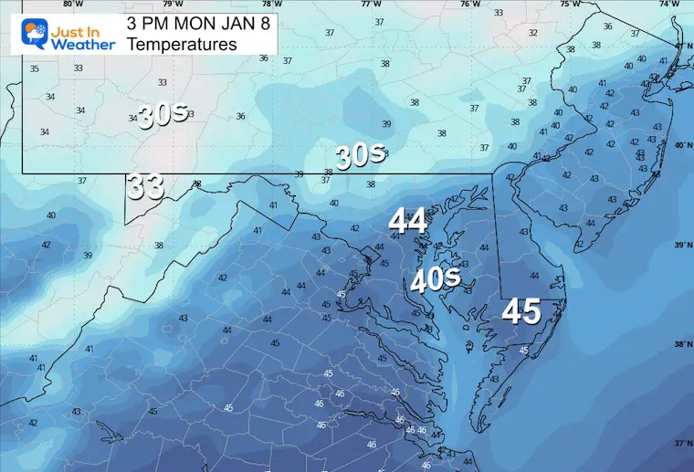
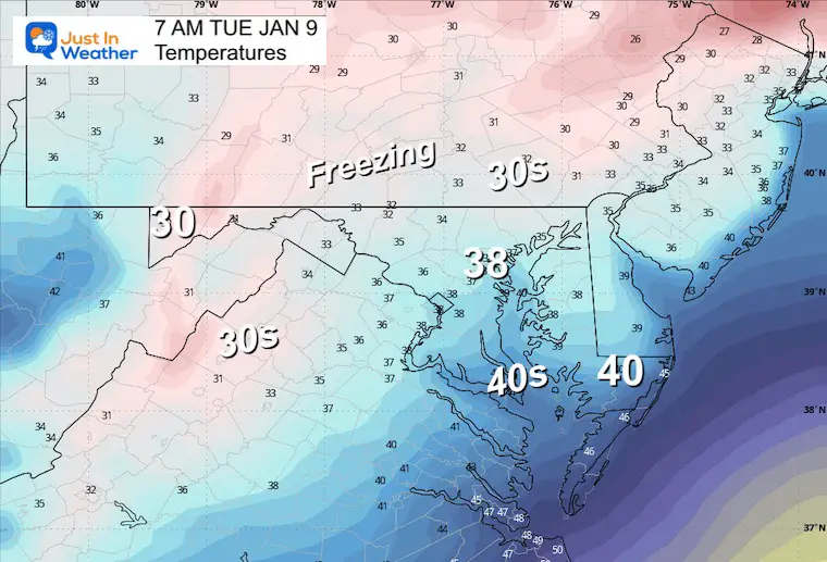
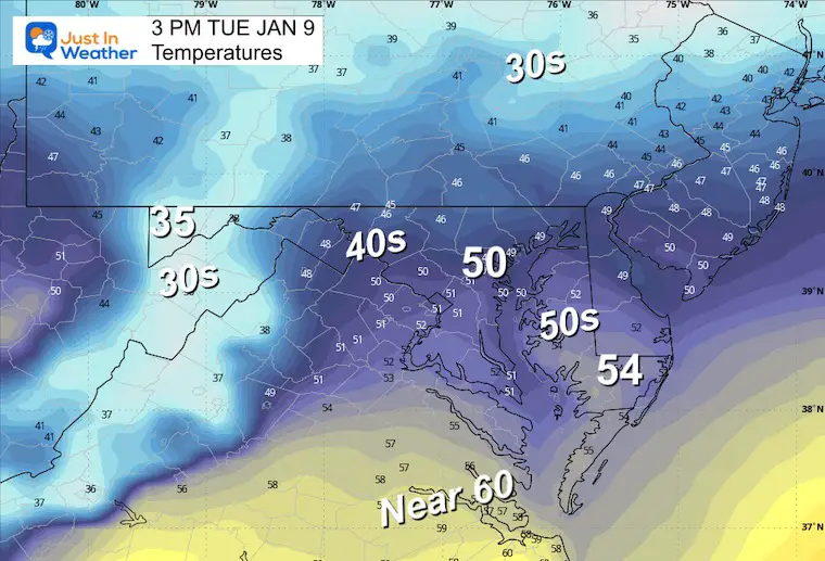
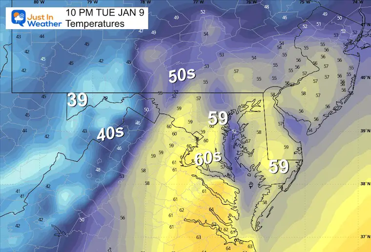
Afternoon Temperatures
Snow Recap Report
See the January 6 totals and compare to my forecast.

Live Snow Cam: McHenry, MD
If you want your snow fix, winter is still in full force in western Maryland.
This webcam is positioned at The Greene Turtle Deep Creek Lake and shows Wisp Resort, including a zoomed-in view of Squirrel Cage, The Face, the terrain park, Boulder, the mountain coaster, the tubing park, and a shot of McHenry Cove at Deep Creek Lake!
CLIMATE DATA: Baltimore
TODAY January 8
Sunrise at 7:26 AM
Sunset at 5:00 PM
Normal Low in Baltimore: 26ºF
Record 4ºF in 1970
Normal High in Baltimore: 43ºF
Record 70ºF 2008
Storm Animation Tuesday Morning To Wednesday Evening
GFS Model
Tuesday Morning
Temperatures
Storm Onset
There may be some snow and icy mix in the mountains, but mainly rain is expected for metro areas. It will arrive between 7 AM and 10 AM.
Temperatures Rise
Afternoon
Night
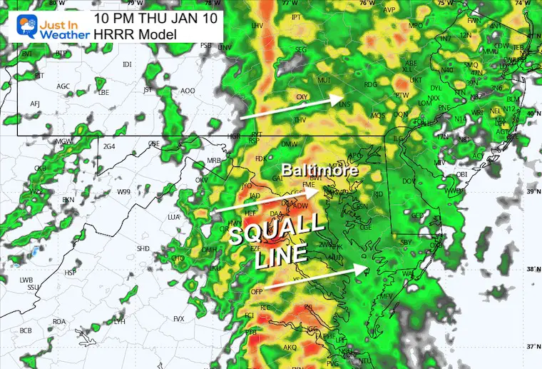
Storm Snapshot Tuesday Night
This squall line will bring the heaviest rain AND strongest winds from 7 PM to Midnight.
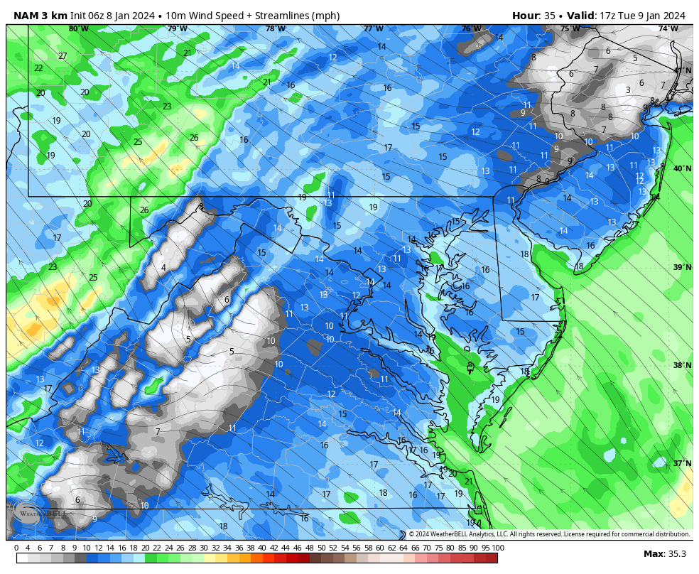
High-Resolution Nam 3 Km Model
Wind Forecast Animation
Noon to Midnight
Note: The Southerly air flow will result in Coastal Flooding on the Chesapeake Bay!
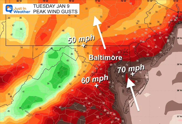
Peak Wind Gusts
50 to 70+ mph (Delmarva) Between 7 PM and Midnight
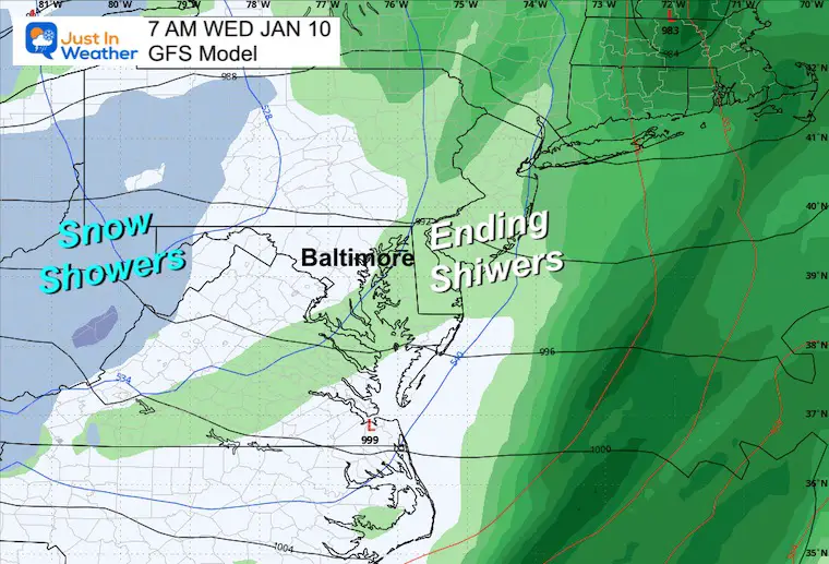
Wednesday Morning
The storm will be moving away.
Snow will return to the mountains while we get cooler winds.
NEXT STORM: Friday to Saturday
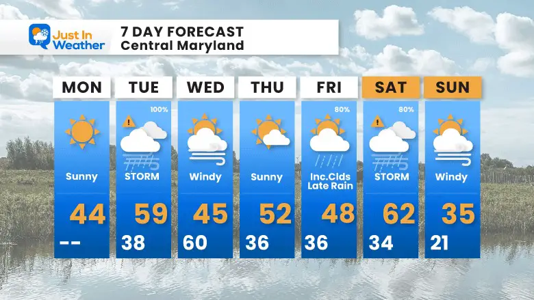
7 Day Forecast
Two storms this week will follow a very similar pattern and may bring us similar results.
The colder air will try to move in after the weekend storm.
Subscribe for eMail Alerts
RECENT Winter Outlook Reports:

El Niño Winter Updates

Computer Models Support East Coast Storm Track

El Niño Advisory
The latest NOAA report is confident in a Very Strong event. Possibly HISTORIC! This refers to the temperatures in the Pacific, with impacts on the US Winter Storm Track.

Winter Weather Folklore: Top 20 and more signals from nature for snow.
NOAA’s Winter Outlook 2024
Winter Outlook 2024 From Two Farmers Almanacs Return to Cold and Snow
Explore More
Maryland Snow Climate History And Other Winter Pages

Faith in the Flakes Gear

STEM Assemblies/In School Fields Trips Are Back
Click to see more and ‘Book’ a visit to your school

Please share your thoughts and best weather pics/videos, or just keep in touch via social media
RESTATING MY MESSAGE ABOUT DYSLEXIA
I am aware there are some spelling and grammar typos and occasional other glitches. I take responsibility for my mistakes and even the computer glitches I may miss. I have made a few public statements over the years, but if you are new here, you may have missed it: I have dyslexia and found out during my second year at Cornell University. It didn’t stop me from getting my meteorology degree and being the first to get the AMS CBM in the Baltimore/Washington region. One of my professors told me that I had made it that far without knowing and to not let it be a crutch going forward. That was Mark Wysocki, and he was absolutely correct! I do miss my mistakes in my own proofreading. The autocorrect spell check on my computer sometimes does an injustice to make it worse. I also can make mistakes in forecasting. No one is perfect at predicting the future. All of the maps and information are accurate. The ‘wordy’ stuff can get sticky. There has been no editor who can check my work when I need it and have it ready to send out in a newsworthy timeline. Barbara Werner is a member of the web team that helps me maintain this site. She has taken it upon herself to edit typos when she is available. That could be AFTER you read this. I accept this and perhaps proves what you read is really from me… It’s part of my charm.
#FITF


