


May 12 Mothers Day Showers And Another Aurora Viewing Tonight May Be Better
Sunday May 12 Mother's Day Morning Report Today, we focus on the all-important Mother’s Day weather and the ongoing impact of the latest Solar Storm. We have been stuck in…
January 2, 2024
Tuesday Night Update
This is a follow up to my earlier report to now include the European Model and my prelude expectations for how this may behave. The trend consolidating the model guidance shows snow arriving on Saturday and ending on Sunday morning.
This is not what kids and teachers want to hear. It may make for great viewing of the Ravens game hosting the Steelers. It may complicate the call for players who start or rest ahead of the playoffs, as well as affect traveling home after the game ends.
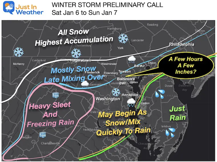
I want to do things differently here. I want to show you my expectations and then get to the latest model analysis. It may help explain why this map is so complicated:
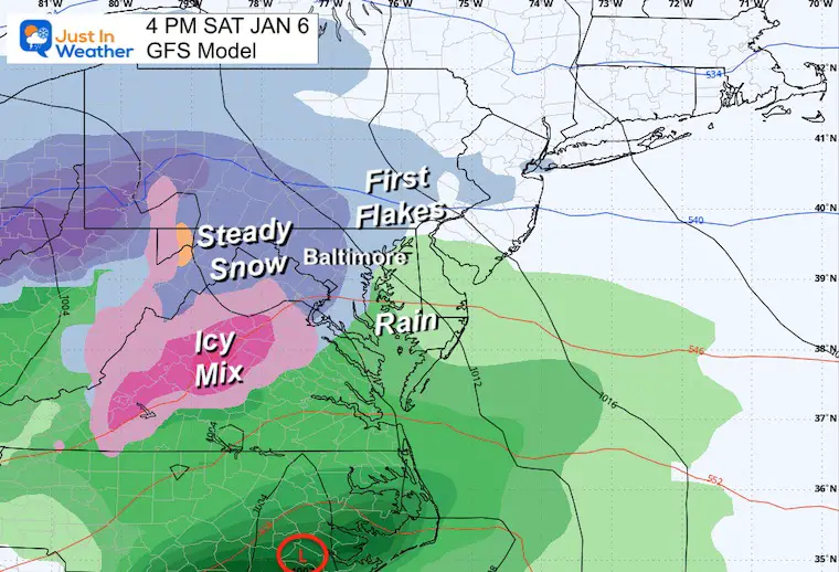
Similar to the GFS I showed earlier, focused across North America to the North of the coastal storm…
A blocking High in Canada AND a 50/50 Low in the North Atlantic are both supporting features for blocking and locking in cold ‘enough’ air for inland snow.
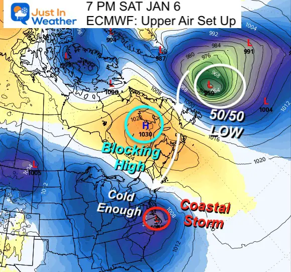
This is a busy map, which I made as a blend of models. So, it will not match perfectly with what you see below.
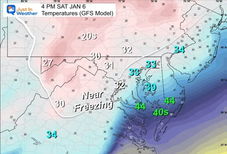
Note: This is the colder GFS Model call. The European model is actually a little warmer.
The marginal temps PLUS warm ground may hinder the initial ability for stickage. The timing of the change over is also not firm yet. So it is IMPOSSIBLE to call snow totals at this time!
Inland where it will remain below freezing will get a moderate accumulation event. I still do not buy into many computer model snow products as they are often overdone.
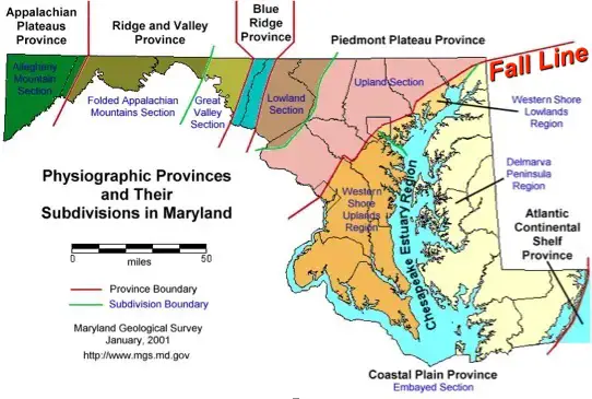
This is where the topography comes into play. Near the Bay and Eastern Shore, it is close to sea level and warmer.
Fall Line: This ‘Upland Section’ moving inland the elevation increases up to 1,000 feet above sea level across northern Baltimore County and to the west. Click here to see more about Maryland Snow.
Snow will be in place or arriving for the Ravens Game.
This does suggest an arrival as snow even into Southern Maryland. At least at the start.
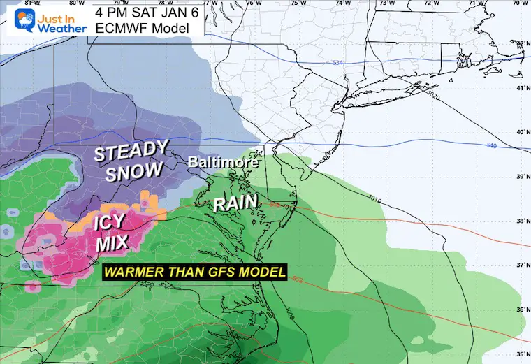
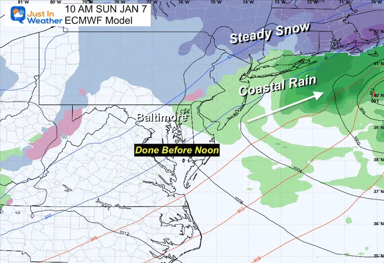
Steady snow will be arriving west of the city, while an ice storm will be the problem along I-81 and Skyline Drive in VA.
This is warmer and shows more rain for Southern Maryland.
The heaviest snow will be falling in the cold areas near and north of Baltimore into southern PA and the mountains at this time.
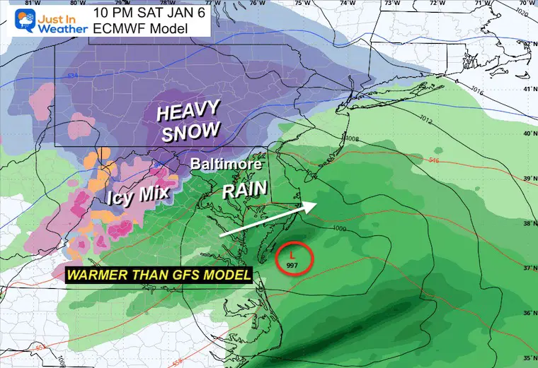
The thought here is the upper-level support may bring the warmer air to the PA line with rain and the mixing north.
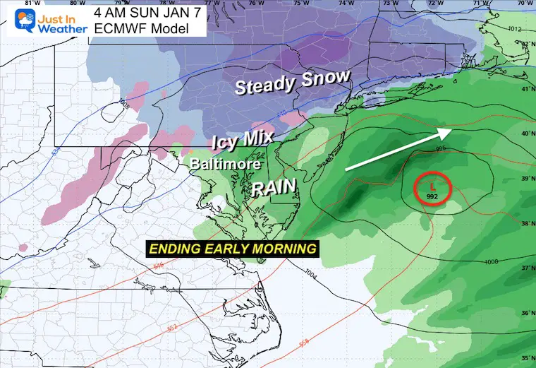
With a faster-arriving storm, it will be departing sooner. For our region, it may be completely done by lunchtime.
This means most impacted areas will have all day to clean up before the work week. However, some high snow areas could hope for school delays on Monday after a thaw and refreeze cycle.
Note: Click to see the GFS model maps I showed earlier.
I expect there will be more adjustments over the next few days. I NEVER lock in on a storm one week away… I would rather look for any trends in the modeling to hold or change the storm. I will also be looking at various different models to see if they are converging on a similar solution or continue to vary widely.
I stand by my principle of 72 hours before the start to get any idea of how much and what we can legitimately expect.
Patience and Faith in the Flakes. This is looking better than the last few years for sure.
It is too early to plot a specific storm timeline. It has not formed yet.
It is too early to plot any rain/snow line. It has not formed yet.
It is too early to suggest how much snow may fall. Computer models may show something, but I believe it is irresponsible to post any snow numbers beyond 72 hours. I’ve been doing this a long time, and most often storms do not play out as first shown. Also, snow suggestions are nearly impossible before the storm actually forms. So, look for my first call on Wednesday afternoon.


Computer Models Support East Coast Storm Track

The latest NOAA report is confident in a Very Strong event. Possibly HISTORIC! This refers to the temperatures in the Pacific, with impacts on the US Winter Storm Track.

Winter Weather Folklore: Top 20 and more signals from nature for snow.
Winter Outlook 2024 From Two Farmers Almanacs Return to Cold and Snow


Click to see more and ‘Book’ a visit to your school

I am aware there are some spelling and grammar typos and occasional other glitches. I take responsibility for my mistakes and even the computer glitches I may miss. I have made a few public statements over the years, but if you are new here, you may have missed it: I have dyslexia and found out during my second year at Cornell University. It didn’t stop me from getting my meteorology degree and being the first to get the AMS CBM in the Baltimore/Washington region. One of my professors told me that I had made it that far without knowing and to not let it be a crutch going forward. That was Mark Wysocki, and he was absolutely correct! I do miss my mistakes in my own proofreading. The autocorrect spell check on my computer sometimes does an injustice to make it worse. I also can make mistakes in forecasting. No one is perfect at predicting the future. All of the maps and information are accurate. The ‘wordy’ stuff can get sticky. There has been no editor who can check my work when I need it and have it ready to send out in a newsworthy timeline. Barbara Werner is a member of the web team that helps me maintain this site. She has taken it upon herself to edit typos when she is available. That could be AFTER you read this. I accept this and perhaps proves what you read is really from me… It’s part of my charm.
#FITF