


Soggy Saturday Update: Rain Timeline Through Preakness In Baltimore
Friday, May 17, 2024 As we approach another weekend, we have yet another weather system bringing us rain. This will make 16 of 20 weekends this year with some wet…
December 24, 2023
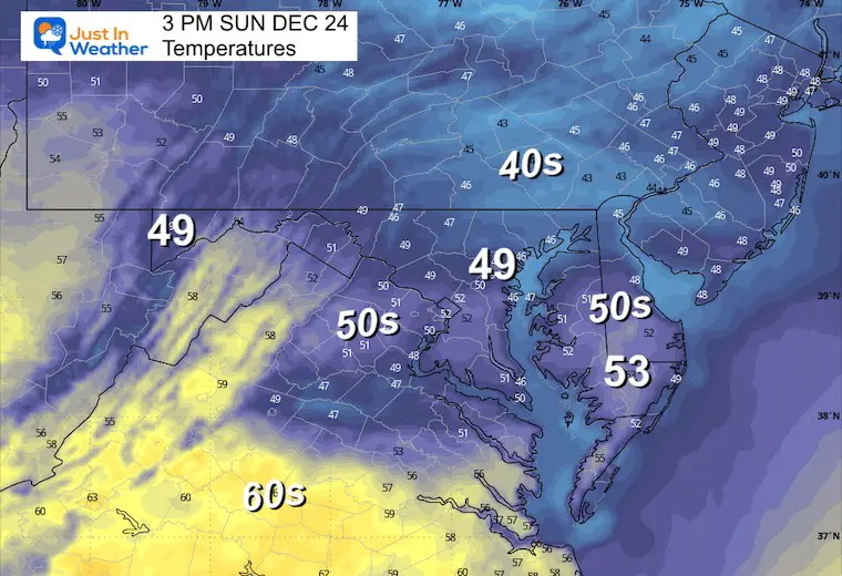
Sunday Christmas Eve Morning Update
This ambiguous weather pattern has produced more rain showers than I suggested this morning. This ‘surprise’ rain has been moderate in parts of Central Maryland. A live radar widget is below to track as we could have damp weather into the afternoon in spots.
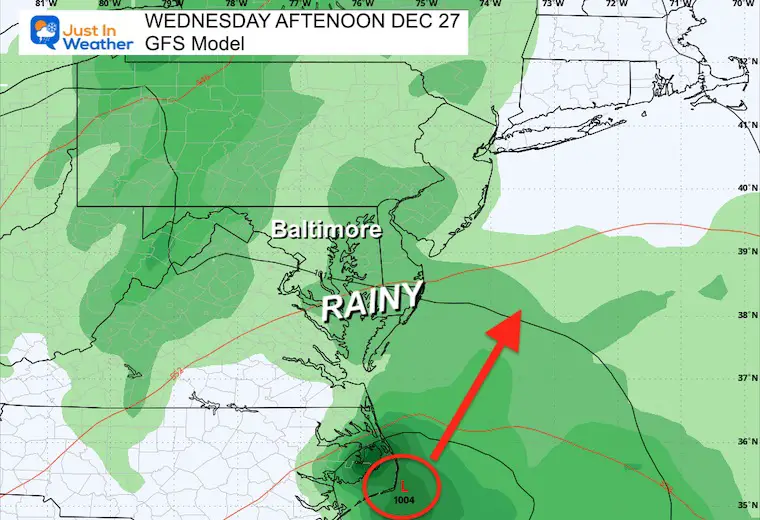
Mild days are moving in ahead of a large storm. We will get the next rain to develop Tuesday and peak on Wednesday. Then a pattern change to the colder trend will be noticeable by the end of the week.
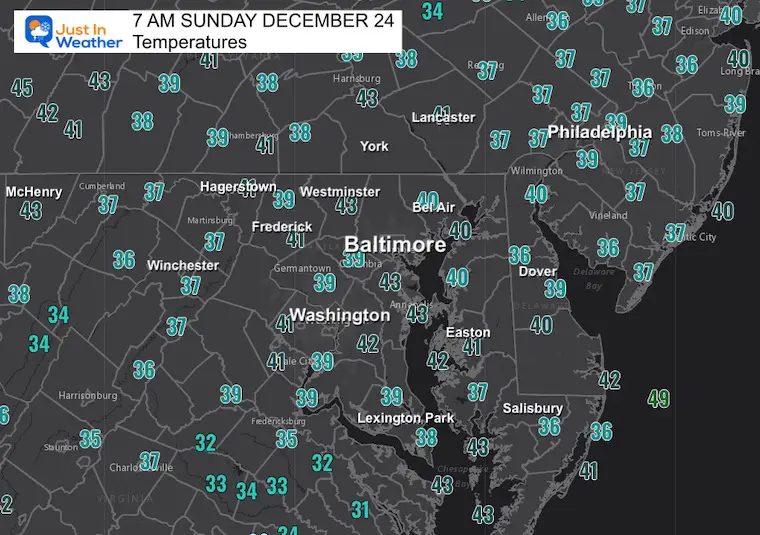
This was a bit more rain than expected. Heavier showers passed just north of Baltimore in Harford County, moving towards Cecil County.
More showers are showing up in Virginia, and it is safe to consider some more will continue through the morning.
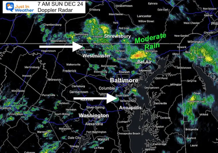
Local rain showers are disconnected from any organized system.
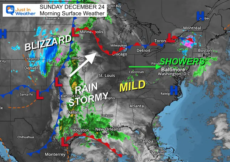
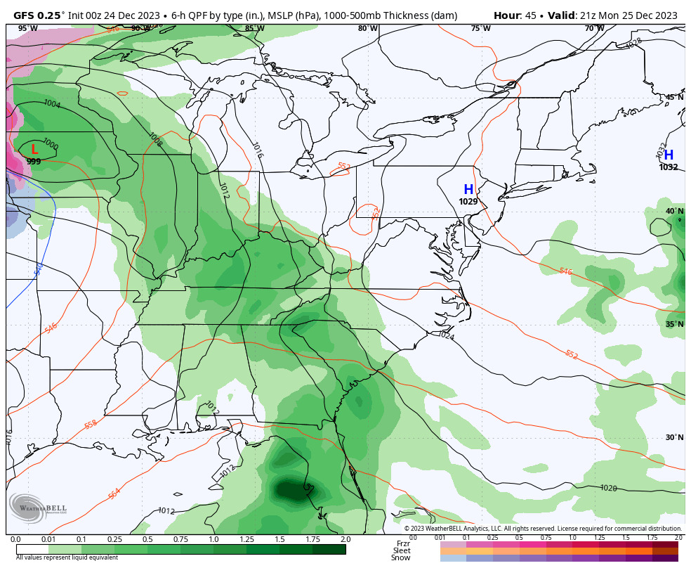
There is one large storm in the middle of the nation. Some severe weather may break out in Texas, while a mild rain is pushing to the Great Lakes.
The cold side of the storm brought snow to Denver, and Blizzard Conditions are expected up to North and South Dakota.
Given the error already, this is just a suggestion for more showers that could continue on the north side into the afternoon. This is not heavy rain, but enough to just be damp.
Sunrise at 7:24 AM
Sunset at 4:49 PM
Normal Low in Baltimore: 28ºF
Record 4ºF in 1983
Normal High in Baltimore: 45ºF
Record 71ºF 2015
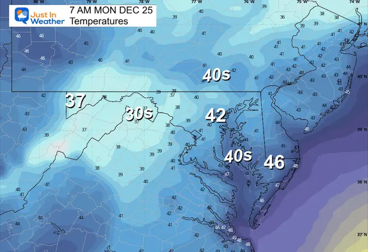
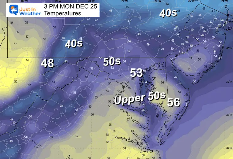
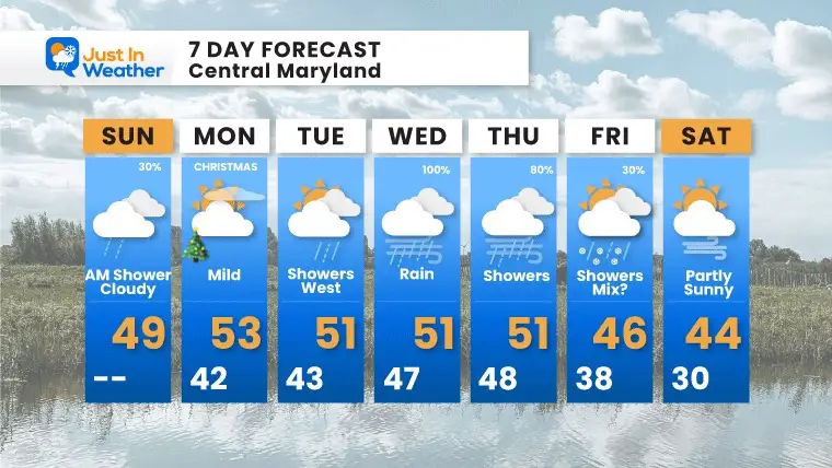
Christmas Day will be the warmest day of the week. A push of mild air as a large storm develops in the middle of the US.
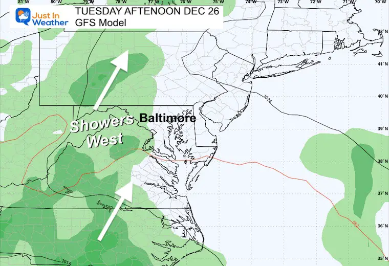
After a mild Christmas, the rain appears to have shifted a little later. But there may be some showers on Tuesday, especially in the mountains and hills west of the cities.
Low Pressure near the coast will bring us the heaviest rain Tuesday night into Wednesday.
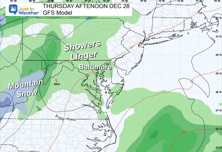
A disturbance behind the storm may extend the rain an additional day. Colder air may develop snow across Northern Pennsylvania.
From a mild start to the week to a noticeable change by the end.
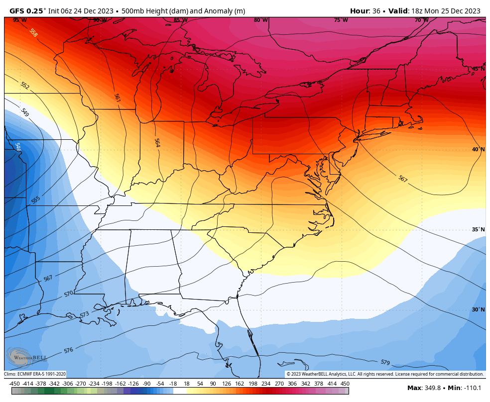
The pattern will change. This is NOT arctic air, but the start of the adjustment in the jet stream.
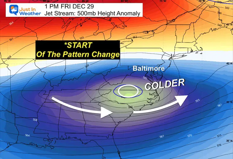
Christmas Day is still looking like the nicest day. Rain showers will approach from the western hills on Tuesday. Wednesday still looks like the rain day. Showers will linger after and might mix with some flurries as the pattern starts to change on Friday.


Computer Models Support East Coast Storm Track

The latest NOAA report is confident in a Very Strong event. Possibly HISTORIC! This refers to the temperatures in the Pacific, with impacts on the US Winter Storm Track.

Winter Weather Folklore: Top 20 and more signals from nature for snow.
Winter Outlook 2024 From Two Farmers Almanacs Return to Cold and Snow


Click to see more and ‘Book’ a visit to your school

I am aware there are some spelling and grammar typos and occasional other glitches. I take responsibility for my mistakes and even the computer glitches I may miss. I have made a few public statements over the years, but if you are new here, you may have missed it: I have dyslexia and found out during my second year at Cornell University. It didn’t stop me from getting my meteorology degree and being the first to get the AMS CBM in the Baltimore/Washington region. One of my professors told me that I had made it that far without knowing and to not let it be a crutch going forward. That was Mark Wysocki, and he was absolutely correct! I do miss my mistakes in my own proofreading. The autocorrect spell check on my computer sometimes does an injustice to make it worse. I also can make mistakes in forecasting. No one is perfect at predicting the future. All of the maps and information are accurate. The ‘wordy’ stuff can get sticky. There has been no editor who can check my work when I need it and have it ready to send out in a newsworthy timeline. Barbara Werner is a member of the web team that helps me maintain this site. She has taken it upon herself to edit typos when she is available. That could be AFTER you read this. I accept this and perhaps proves what you read is really from me… It’s part of my charm.
#FITF