December 11, 2023
The first snow of the season was advertised as possibly more snow than all of last winter for some areas in central Maryland. That actually was the case, as we can see from the comparison of the snow spotter reports to the forecast maps. However, this brings up a longstanding dilemma in both forecasting winter weather and the weather observations logged into the permanent record books.
We will take a local look around the region below.
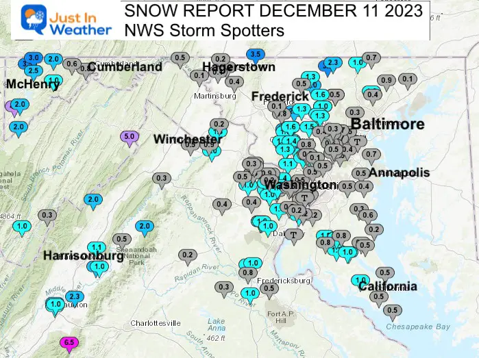
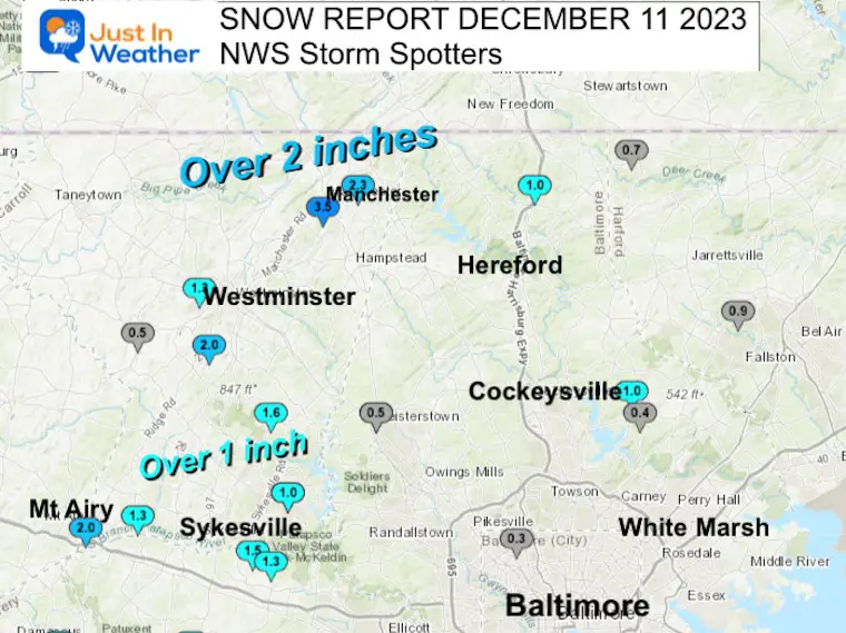
Snow Reports for Maryland and Virginia
Note that while Pennsylvania observations are not on this map, there were widespread 1 to 2+ inches of snow.
Central Maryland did show a lot of light coatings remaining under 1 inch. However, the blue shows over 1 inch in the typical colder inland areas and higher elevations.
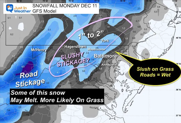
Forecast From GFS Model last night
This seemed to work out pretty well.
BWI Anomaly
Let’s talk about Baltimore’s BWI Airport. This is the official weather station for central Maryland. While the locations have changed many times since 1940, snow reports have been documented since 1883. The current location was Friendship Airport before being renamed to BWI in 1950. The problem is the development around the facility has increased pavement and buildings that can be attributed to a local urban heat island effect.
This has been discussed many times with the temperature running warmer than outside the airport. In winter, we can see the snow reports LOWER than the surrounding measurements to the West and even Southeast… closer to the water (normally warmer).
Technically, BWI recorded only a Trace of snow. Last winter, there was 0.2” on February 1st. This could have surpassed that if it matched any of the surrounding observations, as seen here.
Going forward this winter, we can continue most snow events to display higher amounts surrounding the airport with a lower number on the airport grounds.
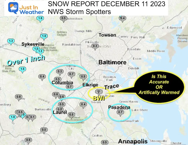
Central Maryland
The areas North and West of Baltimore tend to be colder for three reasons that result in more snow:
- Less Urban/More Rural
- Farther away from the water
- Higher in elevation making it colder
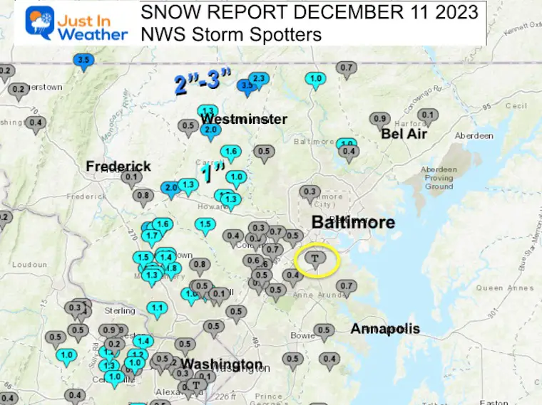
Inland Suburbs
1 inch or more fell about 10 miles away from the Beltway.
2 inches fell in Carroll County north of Westminster above 1,000 Ft in elevation.
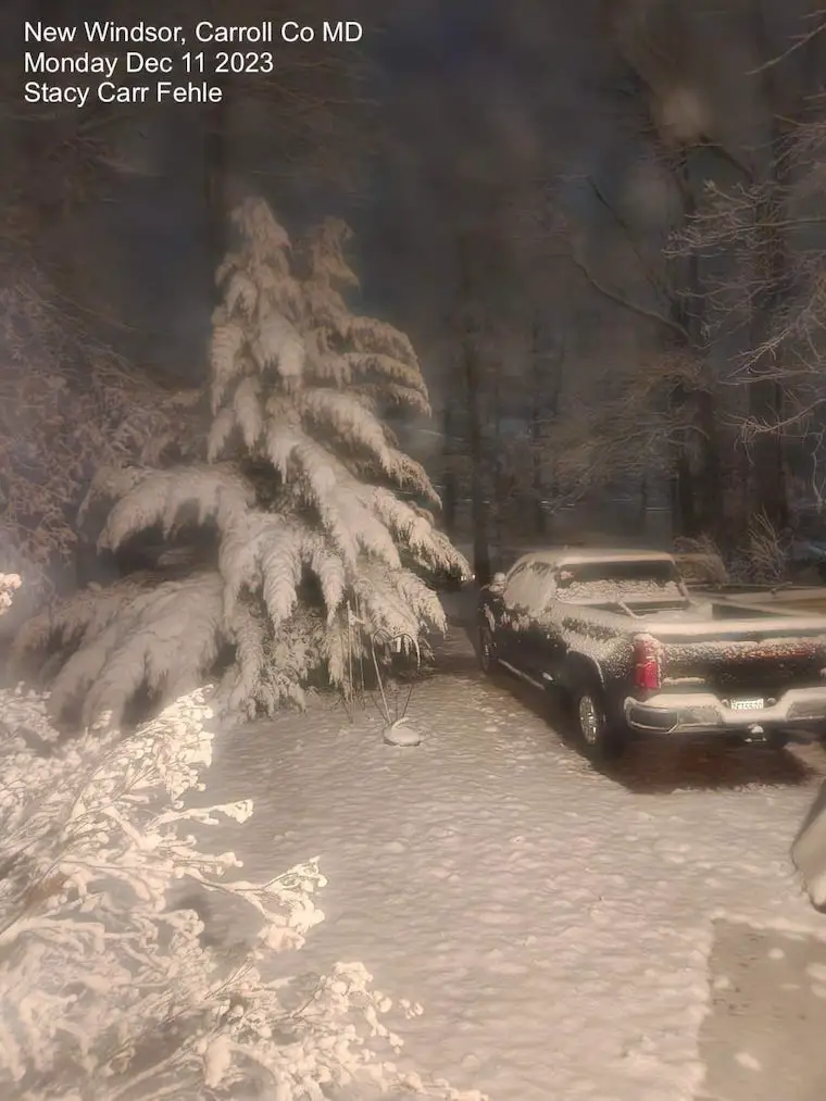
Early Snow Photos
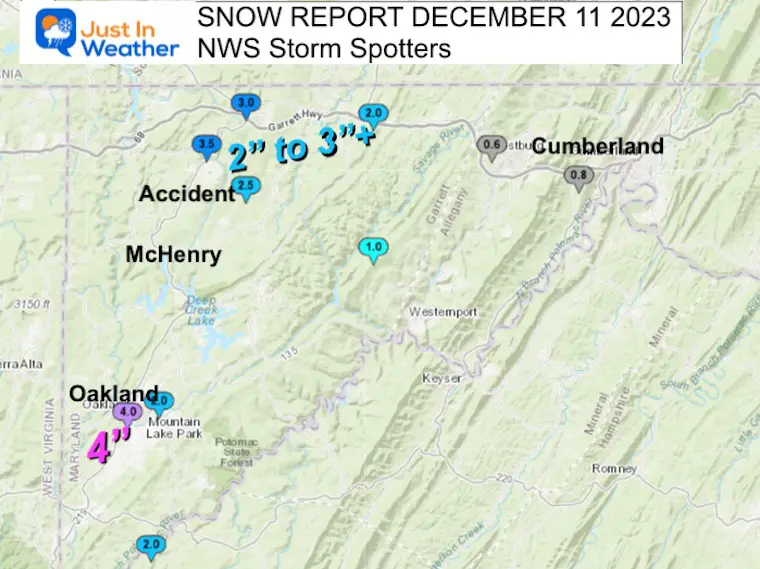
Western Maryland Mountains
This area did show a dramatic increase west of Cumberland where the elevation increases rapidly.
Garrett County ranged from 2 to 4 inches.
Full List Of Snow Spotter Reports
********************STORM TOTAL SNOWFALL********************
LOCATION TOTAL TIME/DATE COMMENTS
SNOWFALL MEASURED
(inches)
DISTRICT OF COLUMBIA
…District of Columbia…
Dalecarlia Reservoir 0.5 800 AM 12/11 Co-Op Observer
MARYLAND
…Allegany County…
Potomac Park 2 NW 0.8 902 AM 12/11 Dept of Highways
Frostburg 0.6 856 AM 12/11 Co-Op Observer
…Anne Arundel County…
Pasadena 1 SE 0.7 700 AM 12/11 CoCoRaHS
Crownsville 3 SSW 0.5 630 AM 12/11 Trained Spotter
Laurel 4 E 0.5 700 AM 12/11 CoCoRaHS
Birdsville WSW 0.4 800 AM 12/11 CoCoRaHS
Severn 2 W 0.4 700 AM 12/11 CoCoRaHS
Bwi Airport T 700 AM 12/11 Official NWS Obs
…Baltimore County…
Glyndon 1 WSW 1.5 415 AM 12/11 Trained Spotter
Long Green 2 NW 1.0 500 AM 12/11 Trained Spotter
Bentley Springs 1 E 1.0 545 AM 12/11 Trained Spotter
Catonsville 1 SSE 0.5 715 AM 12/11 Trained Spotter
Glyndon 1 SW 0.5 824 AM 12/11 Trained Spotter
Long Green 1 SW 0.4 700 AM 12/11 CoCoRaHS
…Baltimore City…
Pikesville 3 SE 0.3 608 AM 12/11 Trained Spotter
…Calvert County…
Prince Frederick 1 W 0.8 800 AM 12/11 CoCoRaHS
North Beach 2 WNW 0.6 725 AM 12/11 CoCoRaHS
Drum Point 2 N 0.5 700 AM 12/11 Trained Spotter
Prince Frederick 1 S 0.5 730 AM 12/11 Trained Spotter
Dunkirk 3.2NNE 0.3 800 AM 12/11 CoCoRaHS
Chesapeake Beach 4 S 0.2 800 AM 12/11 CoCoRaHS
…Carroll County…
Manchester 1 SSW 3.5 600 AM 12/11 Trained Spotter
Millers 2.3 416 AM 12/11 Trained Spotter
Mount Airy SE 2.0 700 AM 12/11 CoCoRaHS
Westminster 3 SSW 2.0 700 AM 12/11 CoCoRaHS
Gamber 1 W 1.6 700 AM 12/11 CoCoRaHS
Westminster 1 W 1.3 600 AM 12/11 CoCoRaHS
Watersville 1 N 1.3 423 AM 12/11 Trained Spotter
Eldersburg 1 SE 1.0 506 AM 12/11 Trained Spotter
Eldersburg 1 E 1.0 700 AM 12/11 CoCoRaHS
Marston 2 N 0.5 700 AM 12/11 CoCoRaHS
…Charles County…
Waldorf 3 S 1.8 800 AM 12/11 CoCoRaHS
Charlotte Hall 2 NW 1.3 600 AM 12/11 Trained Spotter
Bryantown 2 NNE 1.1 700 AM 12/11 Trained Spotter
Bryantown 2 NE 1.1 700 AM 12/11 CoCoRaHS
La Plata 3 ENE 0.8 643 AM 12/11 Trained Spotter
Waldorf 8 ESE 0.8 730 AM 12/11 CoCoRaHS
Indian Head T 659 AM 12/11 Trained Spotter
…Frederick County…
Green Valley 1 WNW 0.8 530 AM 12/11 Trained Spotter
New Market 2 NW 0.1 800 AM 12/11 CoCoRaHS
…Garrett County…
Oakland 4.0 412 AM 12/11 Dept of Highways
Accident 3 NNE 3.5 412 AM 12/11 Dept of Highways
Grantsville 5 W 3.0 412 AM 12/11 Dept of Highways
Accident 4 E 2.5 800 AM 12/11 Public
Mountain Lake Park 1 2.0 452 AM 12/11 Dept of Highways
Grantsville 4 E 2.0 450 AM 12/11 Dept of Highways
Barton 1.0 914 AM 12/11 Public
…Harford County…
Fallston 3 N 0.9 730 AM 12/11 Trained Spotter
Norrisville 1 WSW 0.7 650 AM 12/11 CoCoRaHS
Churchville 1 N 0.1 506 AM 12/11 Trained Spotter
…Howard County…
Glenwood 1 SSW 1.5 700 AM 12/11 CoCoRaHS
Sykesville 2 SSE 1.5 700 AM 12/11 CoCoRaHS
Sykesville 3 SE 1.3 700 AM 12/11 CoCoRaHS
Elkridge 2 W 0.7 550 AM 12/11 Trained Spotter
Historic Ellicott Ci 0.7 730 AM 12/11 Trained Spotter
Columbia 3 SSE 0.6 700 AM 12/11 CoCoRaHS
Simpsonville 1 SSE 0.6 421 AM 12/11 Trained Spotter
Laurel 1 NNE 0.5 700 AM 12/11 CoCoRaHS
Columbia 2 N 0.5 700 AM 12/11 CoCoRaHS
North Laurel 2 ESE 0.5 700 AM 12/11 CoCoRaHS
Clarksville 2 N 0.4 545 AM 12/11 Trained Spotter
Historic Ellicott Ci 0.3 745 AM 12/11 Trained Spotter
…Montgomery County…
Damascus 3 SSW 2.5 413 AM 12/11 Co-Op Observer
Montgomery Village 1 1.8 630 AM 12/11 CoCoRaHS
Montgomery Village 3 1.8 359 AM 12/11 Trained Spotter
Damascus 1 S 1.8 521 AM 12/11 Trained Spotter
Germantown 5 NNE 1.7 600 AM 12/11 CoCoRaHS
Laytonsville 5 NNW 1.6 700 AM 12/11 CoCoRaHS
Damascus 1 SE 1.6 700 AM 12/11 Trained Spotter
North Potomac 4 N 1.6 700 AM 12/11 CoCoRaHS
Germantown 1.5 400 AM 12/11 Public
Gaithersburg 1.5 415 AM 12/11 NWS Employee
Gaithersburg 3 NE 1.4 700 AM 12/11 CoCoRaHS
Gaithersburg 1 SW 1.3 511 AM 12/11 Trained Spotter
Potomac 1 NNW 1.1 700 AM 12/11 CoCoRaHS
Aspen Hill 1 SW 1.0 730 AM 12/11 Trained Spotter
Colesville 2 W 1.0 700 AM 12/11 CoCoRaHS
Silver Spring 6 NNE 0.8 450 AM 12/11 CoCoRaHS
Olney 1 ENE 0.8 542 AM 12/11 CoCoRaHS
Norbeck 1 ESE 0.8 700 AM 12/11 CoCoRaHS
Takoma Park 1 NNW 0.5 700 AM 12/11 CoCoRaHS
Rossmoor 1 ESE 0.5 700 AM 12/11 CoCoRaHS
Colesville 1 SE 0.1 620 AM 12/11 Trained Spotter
…Prince George County…
Beltsville 1 SW 0.5 800 AM 12/11 Co-Op Observer
Bowie 4 S 0.5 700 AM 12/11 CoCoRaHS
Fort Washington 1 SS 0.2 700 AM 12/11 CoCoRaHS
…St. Marys County…
Charlotte Hall 4 ENE 1.0 700 AM 12/11 CoCoRaHS
Mechanicsville 5 NE 1.0 700 AM 12/11 Co-Op Observer
Leonardtown 1 NE 1.0 600 AM 12/11 CoCoRaHS
Ridge 1 N 0.5 700 AM 12/11 CoCoRaHS
Great Mills 4 S 0.5 700 AM 12/11 CoCoRaHS
…Washington County…
Sabillasville 2 NNW 3.5 629 AM 12/11 CoCoRaHS
Pecktonville 3 NNW 0.5 330 AM 12/11 NWS Employee
Boonsboro 3 NNE 0.4 600 AM 12/11 Trained Spotter
Hagerstown 1 ENE 0.2 700 AM 12/11 CoCoRaHS
Hagerstown 4 NNW 0.2 700 AM 12/11 CoCoRaHS
Williamsport 3 ENE 0.1 600 AM 12/11 CoCoRaHS
VIRGINIA
…Arlington County…
Barcroft 1 WNW 0.3 640 AM 12/11 Trained Spotter
Falls Church 1 E 0.2 430 AM 12/11 NWS Employee
Reagan National Apt 0.1 700 AM 12/11 Official NWS Obs
…Augusta County…
Fort Defiance 4 SE 2.3 700 AM 12/11 CoCoRaHS
…City of Alexandria…
Alexandria 1 W 0.1 530 AM 12/11 Trained Spotter
Alexandria 1 ENE T 800 AM 12/11 Trained Spotter
…City of Fairfax…
Fairfax 1 N 0.9 700 AM 12/11 CoCoRaHS
…City of Staunton…
Staunton Water Plant 2.7 800 AM 12/11 Co-Op Observer
Staunton 1 WSW 1.1 630 AM 12/11 CoCoRaHS
Staunton 1 WNW 1.0 700 AM 12/11 CoCoRaHS
…Clarke County…
Berryville 1 NNW 0.5 800 AM 12/11 CoCoRaHS
…Culpeper County…
Culpeper 1 W 0.2 700 AM 12/11 Trained Spotter
…Fairfax County…
Mount Vernon NW 1.5 700 AM 12/11 CoCoRaHS
Vienna 3 N 1.4 700 AM 12/11 CoCoRaHS
Burke 1 S 1.4 902 AM 12/11 Trained Spotter
Chantilly 2 ENE 1.3 442 AM 12/11 Trained Spotter
Herndon 3 S 1.2 700 AM 12/11 CoCoRaHS
Vienna 1 WNW 1.2 425 AM 12/11 Trained Spotter
Oakton E 1.0 800 AM 12/11 CoCoRaHS
Fairfax 3 W 1.0 700 AM 12/11 CoCoRaHS
Vienna 1.0 700 AM 12/11 Co-Op Observer
Herndon 2 ENE 0.9 506 AM 12/11 Trained Spotter
Herndon 1 NNE 0.9 700 AM 12/11 NWS Employee
Falls Church 2 W 0.7 700 AM 12/11 CoCoRaHS
Springfield 2 SW 0.5 700 AM 12/11 CoCoRaHS
Falls Church 1 NNW 0.5 700 AM 12/11 CoCoRaHS
Reston 1 SSW 0.2 647 AM 12/11 Trained Spotter
Alexandria 6 SSW 0.2 700 AM 12/11 CoCoRaHS
Franconia 1 SSE 0.2 700 AM 12/11 CoCoRaHS
…Fauquier County…
Broad Run 3 SSW 0.4 700 AM 12/11 CoCoRaHS
…Highland County…
Monterey 1 SW 2.1 600 AM 12/11 CoCoRaHS
Mill Gap 1 SW 0.6 600 AM 12/11 Co-Op Observer
…Loudoun County…
Bloomery 3 ESE 1.5 530 AM 12/11 Trained Spotter
Round Hill 3 WSW 1.0 525 AM 12/11 CoCoRaHS
Arcola 3 S 1.0 422 AM 12/11 Trained Spotter
Dulles International 0.5 700 AM 12/11 Official NWS Obs
Ashburn N 0.5 700 AM 12/11 CoCoRaHS
Dulles International 0.5 414 AM 12/11 NWS Office
Arcola 1 WNW 0.5 700 AM 12/11 CoCoRaHS
Ashburn 1 SSW 0.4 820 AM 12/11 Trained Spotter
Ashburn 1 W 0.3 800 AM 12/11 NWS Employee
…Nelson County…
Wintergreen 4 WNW 6.5 900 AM 12/11 Broadcast Media
…Page County…
Panorama 2 WSW 2.0 745 AM 12/11 Trained Spotter
Honeyville 1 ESE 0.5 523 AM 12/11 Trained Spotter
…Prince William County…
Manassas 5 SE 1.2 600 AM 12/11 CoCoRaHS
Independent Hill 3 N 1.2 433 AM 12/11 Trained Spotter
Manassas 6 SE 1.0 530 AM 12/11 CoCoRaHS
Dale City 1 W 1.0 700 AM 12/11 Trained Spotter
Manassas 3 NNW 0.4 700 AM 12/11 CoCoRaHS
…Rockingham County…
Massanutten 1 WSW 2.2 800 AM 12/11 Public
Harrisonburg 9 NE 1.1 700 AM 12/11 CoCoRaHS
Massanutten 1 SE 1.0 700 AM 12/11 CoCoRaHS
…Shenandoah County…
Basye 1 NNE 2.0 830 AM 12/11 Public
…Spotsylvania County…
Fredericksburg 5 SSW 1.0 600 AM 12/11 CoCoRaHS
Spotsylvania 9 NW 0.3 700 AM 12/11 CoCoRaHS
…Stafford County…
Glendie 1 N 1.3 505 AM 12/11 Trained Spotter
Ramoth 1 W 1.0 737 AM 12/11 Trained Spotter
Holly Corner 2 E 0.8 532 AM 12/11 Trained Spotter
Fredericksburg 8 ESE 0.5 700 AM 12/11 CoCoRaHS
…Warren County…
Buckton 2 E 0.3 330 AM 12/11 Trained Spotter
WEST VIRGINIA
…Berkeley County…
Falling Waters 2 NW 0.1 700 AM 12/11 CoCoRaHS
…Grant County…
Bayard 2.0 700 AM 12/11 Co-Op Observer
...Hampshire County…
Lehew 2 WNW 5.0 345 AM 12/11 Trained Spotter
…Jefferson County…
Harpers Ferry 13 SSW 0.9 718 AM 12/11 CoCoRaHS
Millville 1 ESE 0.2 512 AM 12/11 Trained Spotter
...Pendleton County…
Franklin 1 W 1.0 830 AM 12/11 County Emergy Mgmt
Fort Seybert 3 NE 0.3 600 AM 12/11 CoCoRaHS
RECENT Winter Outlook Reports:

El Niño Winter Updates

Computer Models Support East Coast Storm Track

El Niño Advisory
The latest NOAA report is confident in a Very Strong event. Possibly HISTORIC! This refers to the temperatures in the Pacific, with impacts on the US Winter Storm Track.

Winter Weather Folklore: Top 20 and more signals from nature for snow.
NOAA’s Winter Outlook 2024
Winter Outlook 2024 From Two Farmers Almanacs Return to Cold and Snow
Subscribe for eMail Alerts
Explore More
Maryland Snow Climate History And Other Winter Pages

Faith in the Flakes Gear

STEM Assemblies/In School Fields Trips Are Back
Click to see more and ‘Book’ a visit to your school

Subscribe for eMail Alerts
Please share your thoughts and best weather pics/videos, or just keep in touch via social media
RESTATING MY MESSAGE ABOUT DYSLEXIA
I am aware there are some spelling and grammar typos and occasional other glitches. I take responsibility for my mistakes and even the computer glitches I may miss. I have made a few public statements over the years, but if you are new here, you may have missed it: I have dyslexia and found out during my second year at Cornell University. It didn’t stop me from getting my meteorology degree and being the first to get the AMS CBM in the Baltimore/Washington region. One of my professors told me that I had made it that far without knowing and to not let it be a crutch going forward. That was Mark Wysocki, and he was absolutely correct! I do miss my mistakes in my own proofreading. The autocorrect spell check on my computer sometimes does an injustice to make it worse. I also can make mistakes in forecasting. No one is perfect at predicting the future. All of the maps and information are accurate. The ‘wordy’ stuff can get sticky. There has been no editor who can check my work when I need it and have it ready to send out in a newsworthy timeline. Barbara Werner is a member of the web team that helps me maintain this site. She has taken it upon herself to edit typos when she is available. That could be AFTER you read this. I accept this and perhaps proves what you read is really from me… It’s part of my charm.
#FITF


