December 10, 2023
Sunday Morning Update
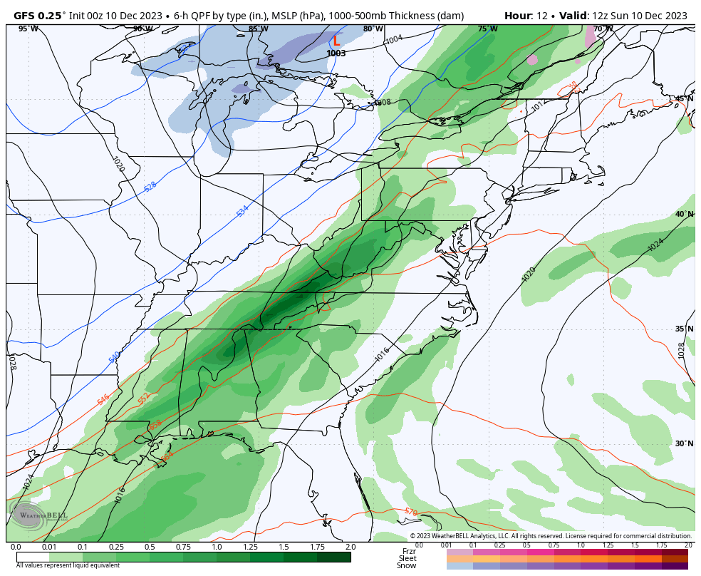
The storm system developing this morning is showing signs of a big impact. A wave of Low Pressure will ride along the front. This will slow it down, enhancing the rainfall later today, then allow colder air to get pulled in and change over to slushy snow early Monday.
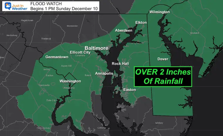
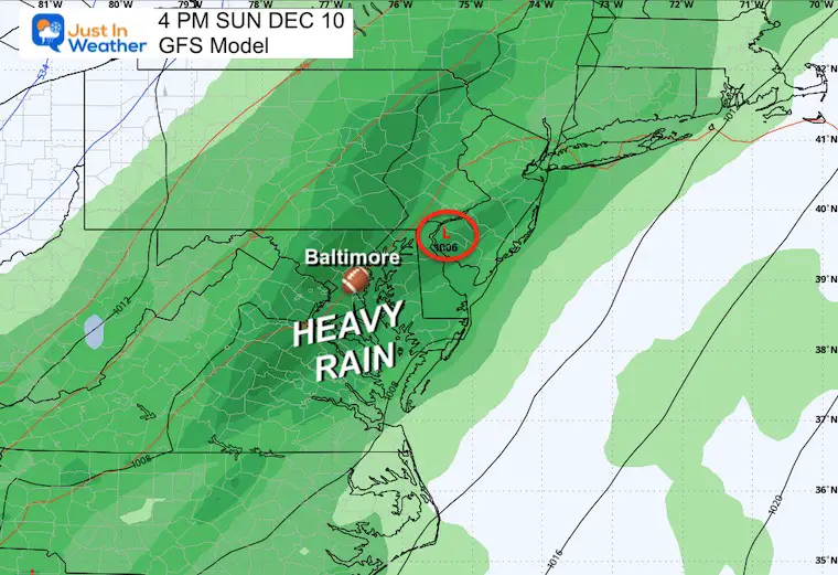
The heaviest rain will fall in metro Baltimore towards the coast. That is where the Flood Watch has been concentrated.
The snow part will occur overnight and into early Monday morning. Temperatures will remain ABOVE freezing, so stickage will be challenging.
As of now, I believe a coating on the grass is likely and could be more than all of last winter for metro areas.
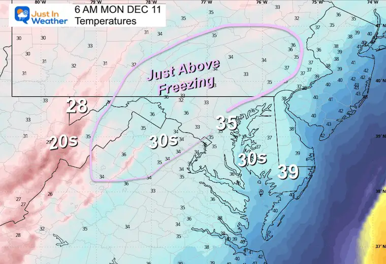
The colder suburbs West and North of Baltimore will be just above freezing, but heavier snow bursts could coat roads and lead to school delays.
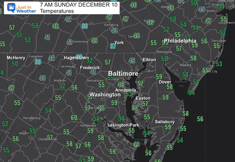
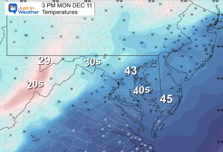
Morning Temperatures
A mild start as we get warmer winds on this side of the storm.
Flood Watch
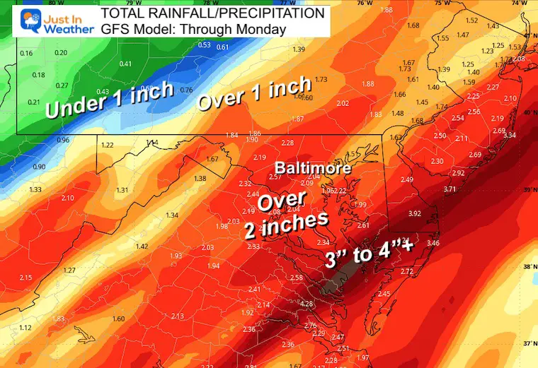
Rain Forecast
Full details and the snow part below…
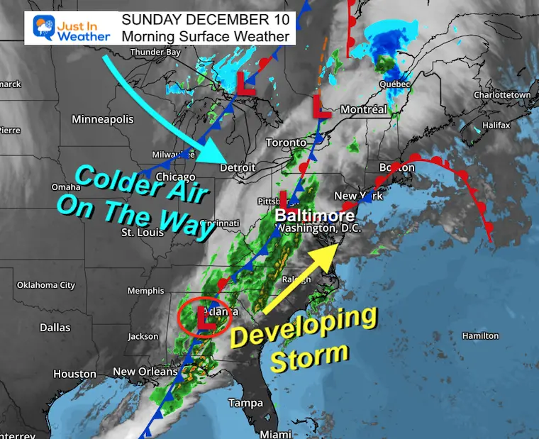
Morning Surface Weather
The developing storm: This front is slowing and nearly stalling as a wave of Low Pressure is forming near Atlanta. Rain will be expanding all morning, then become heavy this afternoon and tonight.
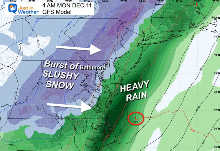
As that Low passes off the coast, it will pull in the colder air and allow the snow to develop in central Maryland/PA after midnight.
Live Radar Widget
Storm Animation: Sunday Morning to Monday Evening
Snapshots
4 PM
The Ravens Game will be wet! Heavier rain may fall later in the game and through the evening. Some lighting/thunder is possible.
Winds will be gusting from the South up to 30 mph. Personally, I am sitting Justin Tucker on my Fantasy Team bench, considering the weather limiting his use of long-range.
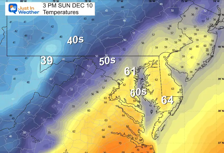
Temperatures
The 60s should reach Baltimore with the strong winds. The colder air will be starting to show up in the mountains.
Monday Morning
Change to snow… See the closer look below.
CLIMATE DATA: Baltimore
TODAY December 10
Sunrise at 7:15 AM
Sunset at 4:44 PM
Normal Low in Baltimore: 31ºF
Record 1ºF in 1876
Normal High in Baltimore: 49ºF
Record 72ºF 1966
–Winter Outlook Reports Links below the 7 Day Forecast–
Monday Morning
There will be a mix to sleet and end with snow.
The clouds will be cold, but the ground will be above freezing. This makes stickage complicated and more likely just on the grass. Inland areas may get more slush, and some roads could be compromised. Closer to Baltimore and southward, there could up a coating to 1 inch on the grass, with wet roads.
3 AM Radar Simulation
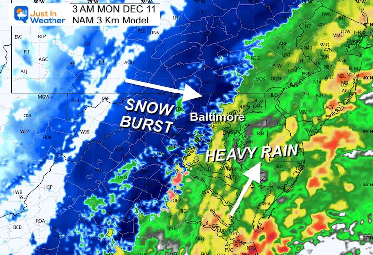
Radar Simulation 3 AM to Noon
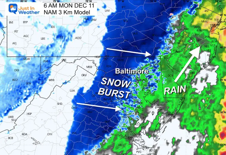
Snapshot: 6 AM
Temperatures Just ABOVE Freezing
With the burst of snow, there may be a brief covering on some roads in the normally colder areas NORTH AND WEST of the city!
Yes, there may be some school delays.
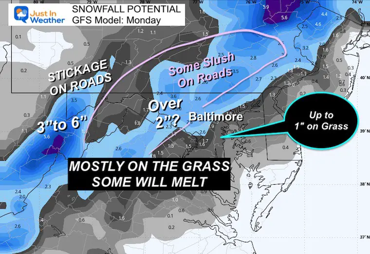
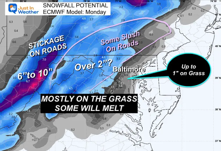
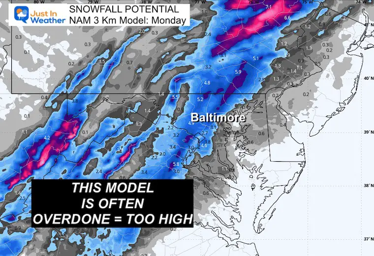
SNOWFALL POTENTIAL
It is IMPORTANT to note that this product shows what may fall, but not all will stick.
These models are often overdone, especially with initial melting on warmer and wet ground.
There may be enough to coat the roads briefly in the colder suburbs, and schools could have delays. I will have an update on my call later today.
GFS Model
ECMWF Model
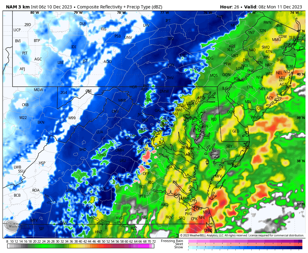
NAM 3 Km
I know this product has been floating around, AND it has a history of overplaying snow totals. I do not support this.
Afternoon Weather
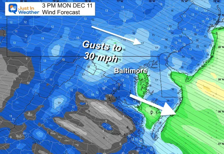
Wind Forecast
Colder winds gusting to 30 mph will dry us out.
Temperatures
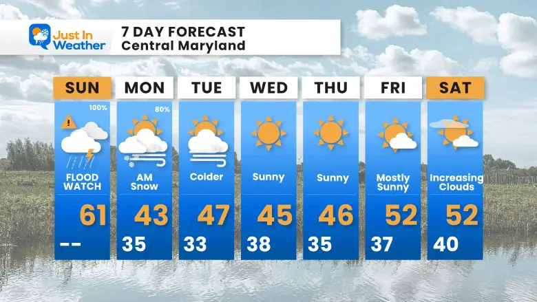
7 Day Forecast
The pattern of a weekend storm will be followed by colder air for much of next week.
RECENT Winter Outlook Reports:

El Niño Winter Updates

Computer Models Support East Coast Storm Track

El Niño Advisory
The latest NOAA report is confident in a Very Strong event. Possibly HISTORIC! This refers to the temperatures in the Pacific, with impacts on the US Winter Storm Track.

Winter Weather Folklore: Top 20 and more signals from nature for snow.
NOAA’s Winter Outlook 2024
Winter Outlook 2024 From Two Farmers Almanacs Return to Cold and Snow
Subscribe for eMail Alerts
Explore More
Maryland Snow Climate History And Other Winter Pages

Faith in the Flakes Gear

STEM Assemblies/In School Fields Trips Are Back
Click to see more and ‘Book’ a visit to your school

Subscribe for eMail Alerts
Please share your thoughts and best weather pics/videos, or just keep in touch via social media
RESTATING MY MESSAGE ABOUT DYSLEXIA
I am aware there are some spelling and grammar typos and occasional other glitches. I take responsibility for my mistakes and even the computer glitches I may miss. I have made a few public statements over the years, but if you are new here, you may have missed it: I have dyslexia and found out during my second year at Cornell University. It didn’t stop me from getting my meteorology degree and being the first to get the AMS CBM in the Baltimore/Washington region. One of my professors told me that I had made it that far without knowing and to not let it be a crutch going forward. That was Mark Wysocki, and he was absolutely correct! I do miss my mistakes in my own proofreading. The autocorrect spell check on my computer sometimes does an injustice to make it worse. I also can make mistakes in forecasting. No one is perfect at predicting the future. All of the maps and information are accurate. The ‘wordy’ stuff can get sticky. There has been no editor who can check my work when I need it and have it ready to send out in a newsworthy timeline. Barbara Werner is a member of the web team that helps me maintain this site. She has taken it upon herself to edit typos when she is available. That could be AFTER you read this. I accept this and perhaps proves what you read is really from me… It’s part of my charm.
#FITF


