November 26, 2023
Sunday Morning Update
Today is the day that last week looked like a moderate to strong coastal storm would affect the return travel to end Thanksgiving Weekend. This is yet another example of the inconsistencies of the computer guidance. Then, the storm was a miss, and now is back in a modest form.
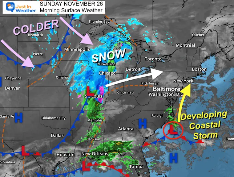
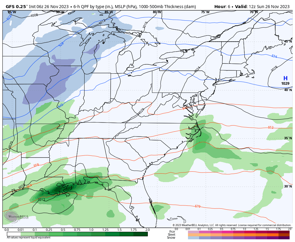
There is a coastal Low developing that will bring rain this afternoon and evening near and east of I-95 through the big cities and Delmarva.
In the central US, a colder storm has dropped moderate snow, and that will reach Chicago today. This may have a ripple effect on flights across the country.
Colder air will follow, and we could have some flurries reaching our metro areas on Tuesday.
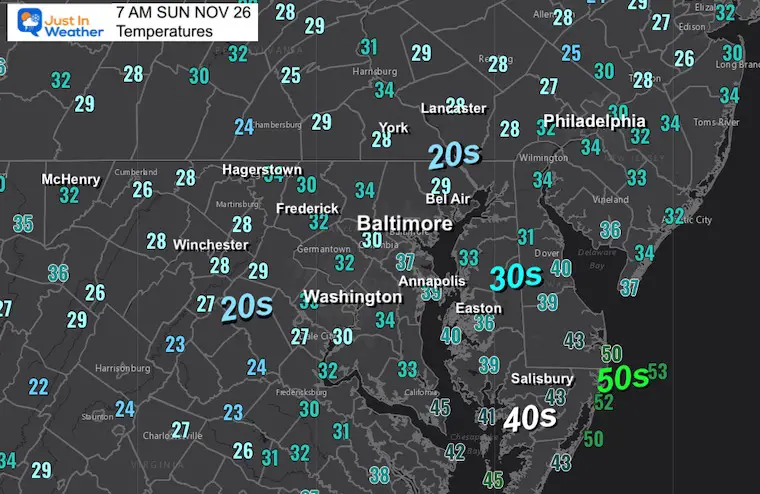
Morning Temperatures
Still in a colder than average pattern.
Morning Surface Weather
Low Pressure developing off the North Carolina coast will move north and bring us rain this afternoon and evening.
The other Low Pressure near St. Louis is the colder snowmaker. Some areas have had 4 to 8 inches of snow. Chicago is expecting a few inches today, but more importantly, it will be sticking on the roads. Also, planes will need to undergo de-icing to add to flight delays.
Note: There is an Arctic Air Mass that will follow these systems and reach us on Tuesday!
Storm Forecast Animation: Sunday Morning to Monday Afternoon
Local Forecast:
Radar Simulation 10 AM to Midnight
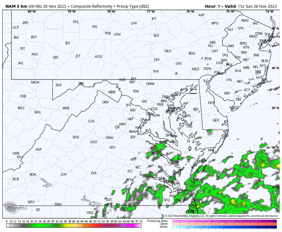
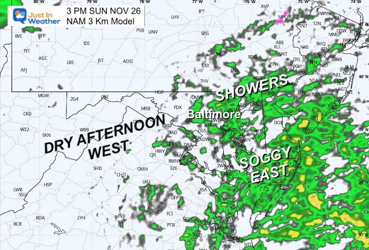
Snapshot at 3 PM
Rain will be falling in central Maryland, with heavier rain near the coast.
Farther west, the day should remain dry. The mountains will get their rain (and snow) tonight.
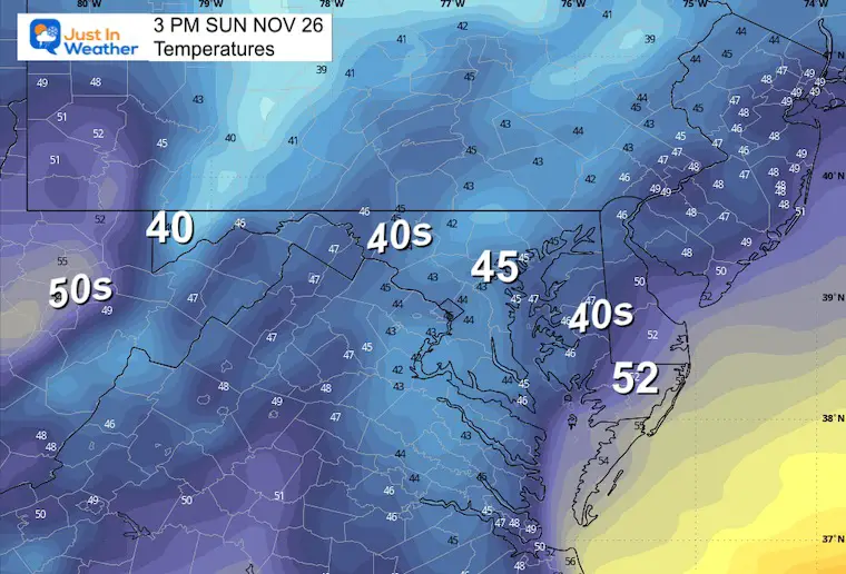
Temperatures
It will be a chilly and raw afternoon with the rain.
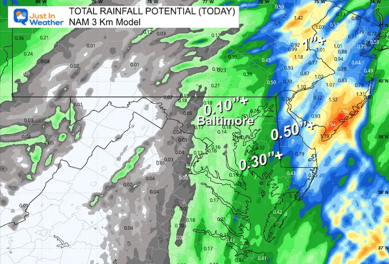
Rain Totals
CLIMATE DATA: Baltimore
TODAY November 26
Sunrise at 7:02 AM
Sunset at 4:46 PM
Normal Low in Baltimore: 34ºF
Record 15ºF in 1950
Normal High in Baltimore: 53ºF
Record 72ºF 1979
Winter Outlook Reports:

El Niño Winter Updates
Computer Models Support East Coast Storm Track

El Niño Advisory
The latest NOAA report is confident in a Very Strong event. Possibly HISTORIC! This refers to the temperatures in the Pacific, with impacts on the US Winter Storm Track.

Winter Weather Folklore: Top 20 and more signals from nature for snow.
NOAA’s Winter Outlook 2024
Winter Outlook 2024 From Two Farmers Almanacs Return to Cold and Snow
Subscribe for eMail Alerts
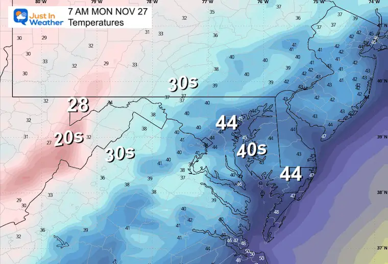
Monday Morning
Temperatures
Weather Set Up
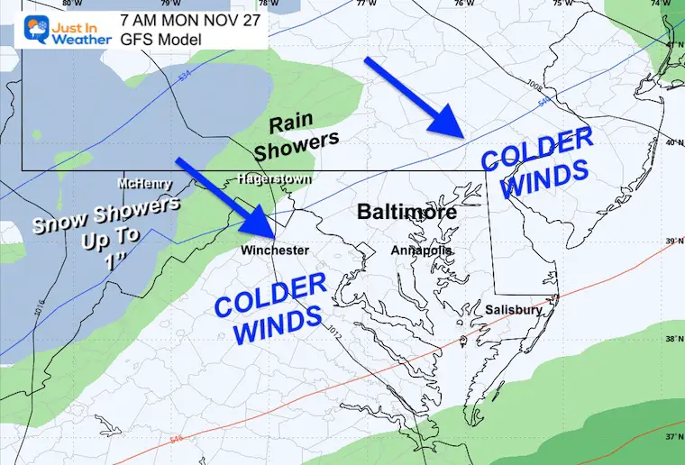
The other storm system will get blocked by the mountains. On the western edge, there will be rain, changing to snow at elevations of over 2,000 feet. Up to 1 inch may coat the ground in parts of Garrett County and the peaks of West Virginia.
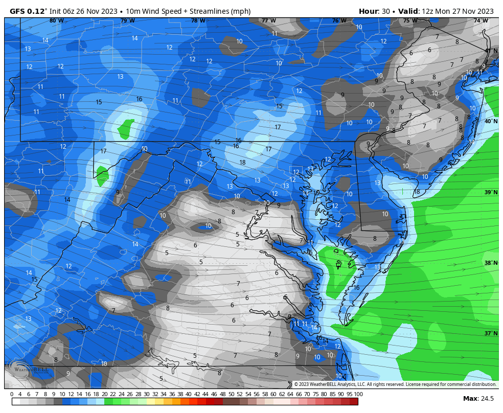
Wind Forecast 7 AM to 3 PM
Colder winds from the West and Northwest may gust from 20 to 30 mph at times, leading the surge of colder air.
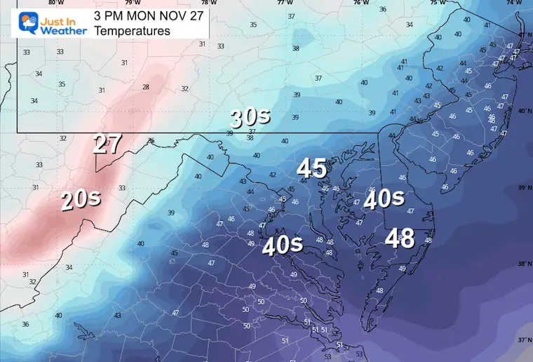
Afternoon Temperatures
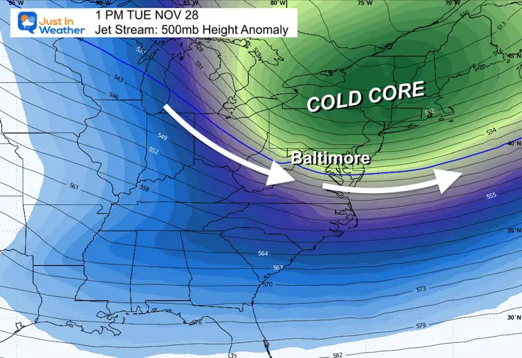
Jet Stream Monday Morning to Thursday Afternoon
The core of the Cold Air will arrive on Tuesday, then modify towards the end of the week.

Snapshot: Tuesday Afternoon
The core of this colder air/Arctic Blast will be felt this day!
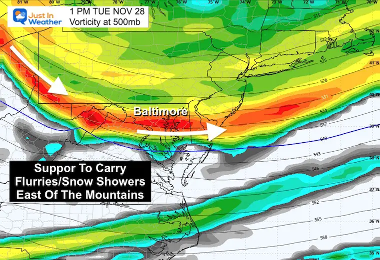
Jet Stream Vorticity
The upper air disturbance helping to bring in this air mass, may carry enough energy to bring snow showers and flurries east of the mountains on Tuesday afternoon.
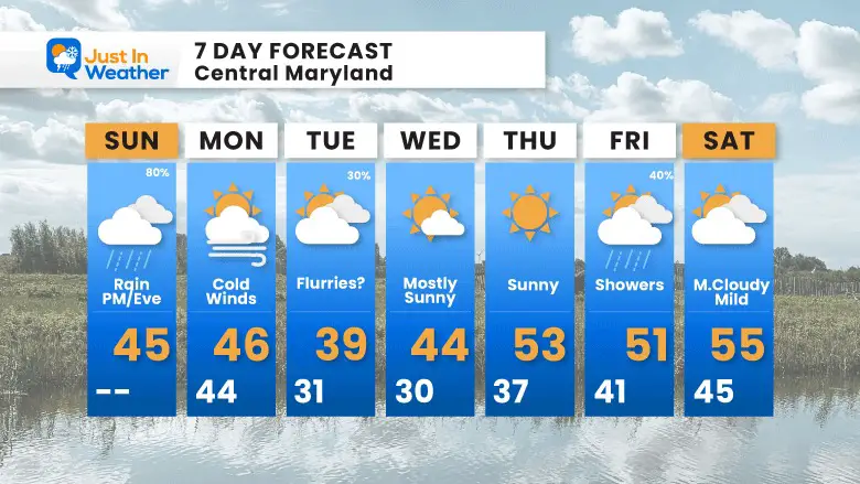
7 Day Forecast
It’s still looking like an early winter setup!
Colder air during the week will accompany a disturbance that may bring snow flurries even into metro areas on Tuesday.
A coating of snow is possible in the mountains.
Temperatures remain below average throughout the week.
Explore More
Maryland Snow Climate History And Other Winter Pages

Faith in the Flakes Gear

STEM Assemblies/In School Fields Trips Are Back
Click to see more and ‘Book’ a visit to your school

Subscribe for eMail Alerts
Please share your thoughts and best weather pics/videos, or just keep in touch via social media
RESTATING MY MESSAGE ABOUT DYSLEXIA
I am aware there are some spelling and grammar typos and occasional other glitches. I take responsibility for my mistakes and even the computer glitches I may miss. I have made a few public statements over the years, but if you are new here, you may have missed it: I have dyslexia and found out during my second year at Cornell University. It didn’t stop me from getting my meteorology degree and being the first to get the AMS CBM in the Baltimore/Washington region. One of my professors told me that I had made it that far without knowing and to not let it be a crutch going forward. That was Mark Wysocki, and he was absolutely correct! I do miss my mistakes in my own proofreading. The autocorrect spell check on my computer sometimes does an injustice to make it worse. I also can make mistakes in forecasting. No one is perfect at predicting the future. All of the maps and information are accurate. The ‘wordy’ stuff can get sticky. There has been no editor who can check my work when I need it and have it ready to send out in a newsworthy timeline. Barbara Werner is a member of the web team that helps me maintain this site. She has taken it upon herself to edit typos when she is available. That could be AFTER you read this. I accept this and perhaps proves what you read is really from me… It’s part of my charm.
#FITF


