September 19, 2023
Tuesday Evening Update
Since yesterday I started keeping close tabs on the potential for a tropical-like system to form off the Southeast US coast. This is common on the southern end of stalling cold fronts that can send heavy rain inland regardless of whether it gets named or not.
I continue to be very cautious of computer model guidance with the many documented errors I have shared this year. The model maps I show below do have a consistency of this storm forming. The trend has been a little faster arrival for us and for a stronger event. Please consider some fluctuation in timing and totals as we continue to track over the next few days.
Tuesday Evening Set Up
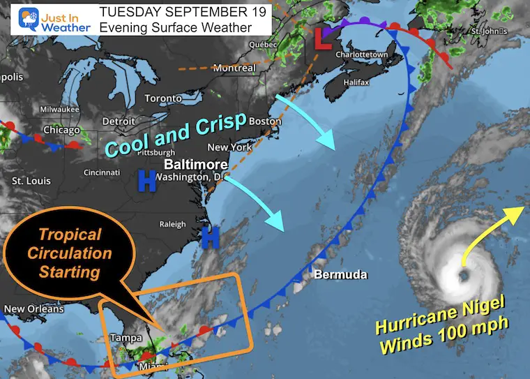
High Pressure has brought a cool and crisp air mass to the East Coast. The old cold front is approaching Bermuda. Hurricane Nigel has winds of 100 mph and will be blocked by this front and get forced to turn away.
The tail end of that front is stalling in Southern Florida. This is where tropical circulation is beginning to develop. This may be identified as an area of interest or a tropical depression by Friday. There is no promise it will become a fully fledged tropical system, but it will have ample moisture as it gets a lift to the north this weekend.
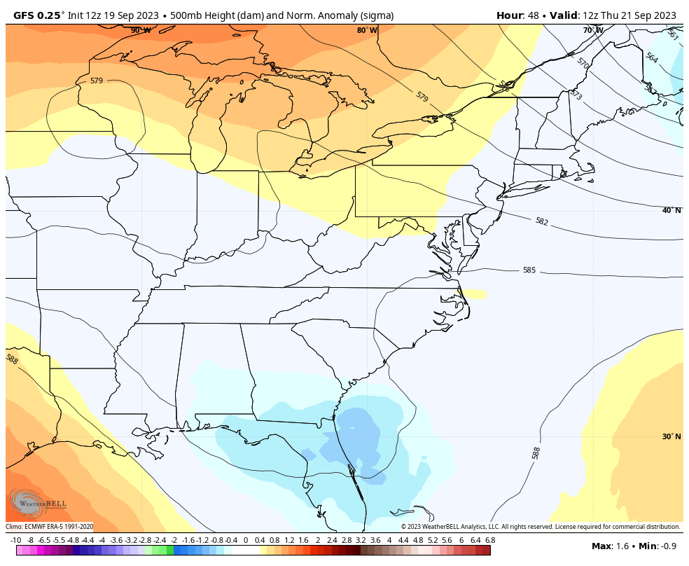
Jet Stream Animation: Thursday Morning to Sunday Morning
The upper-level Low will develop and lift north, remaining mostly closed and stacked very close to the surface Low. This is what will allow the storm to slow down or nearly stall as it reaches the Mid-Atlantic Saturday into early Sunday. Then it will open up and get pulled away with the main flow.
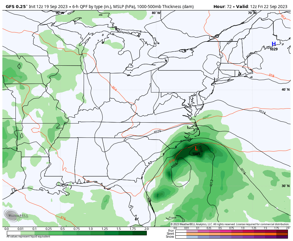
Surface Forecast:
Over the 48-hour period, Low Pressure may only travel from coastal North Carolina to Ocean City, MD.
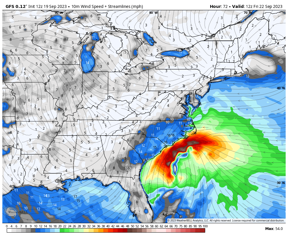
Surface Wind Forecast: Friday Morning To Sunday Morning
The core of Low Pressure may bring in the strongest winds north of the center. This is a signal that the storm will not be purely tropical and get enhanced on a developing coastal front. This will enhance cooler winds on the North side.
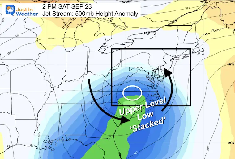
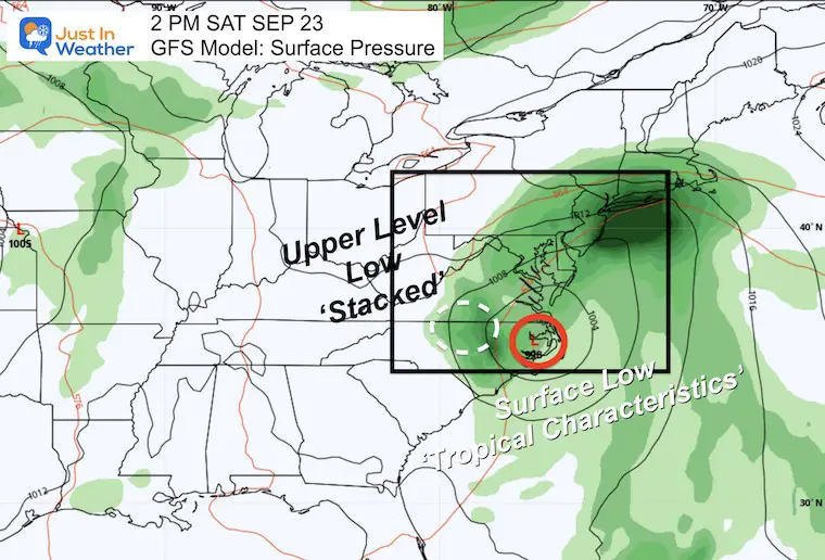
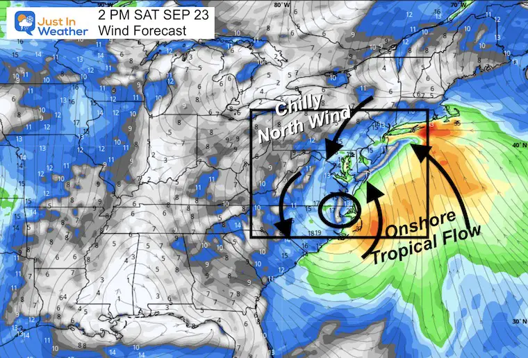
Saturday Afternoon Snapshot
Jet Stream
The Upper-Level Low may be located across the North Carolina and Virginia border. By ‘Stacked’ I am referring to the close proximity to the surface Low Pressure just to the east.
Surface Weather
Comparing the Upper Level Low to the Surface Low we can see how close they are located. The upper level is the forcing of forward movement. When nearly stacked on top, the surface low moves very slowly. This is why it will last nearly all weekend.
Wind Forecast
The strongest winds may have already passed in the morning. We still see a very strong flow to the East and North of the Low-Pressure center.
Closer Look: Mid-Atlantic
I want to start with timeline snapshots, then the animation below to watch this develop in motion.
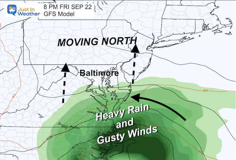
Friday Night
Rain will reach Southern Maryland before sunset, while clouds and a chilly wind will expand north into Pennsylvania.
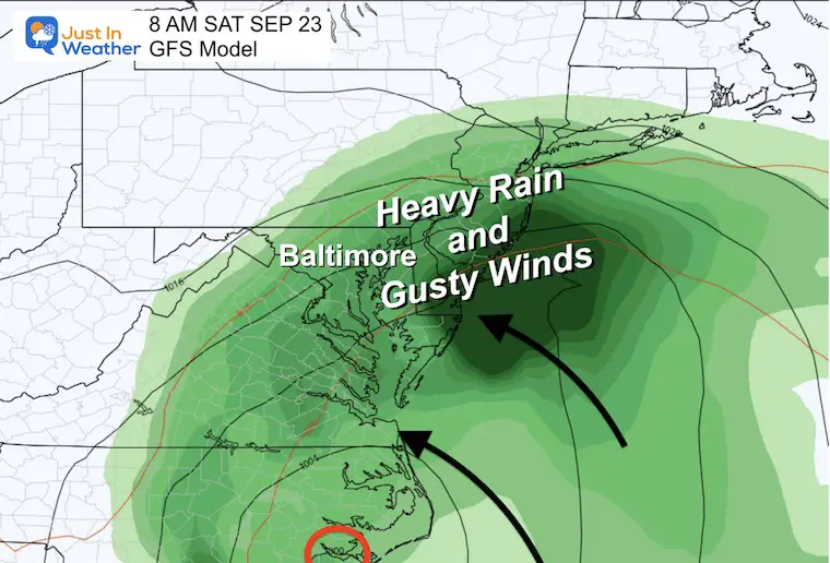
Saturday Morning
The heaviest rain and strongest winds may be fully entrenched across most of our region.
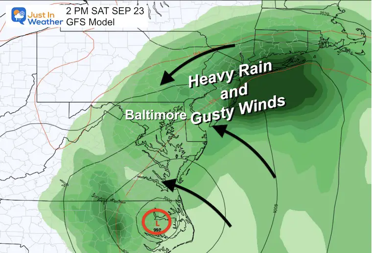
Saturday Afternoon
A chilly rain and gusty winds will continue. The heaviest rain may shift north up the coast towards metro New York.
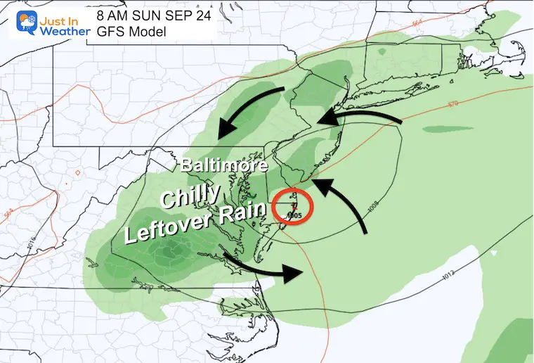
Sunday Morning
The Low-Pressure may spin itself out while the stacked upper low begins to open up. Rain showers and a chilly breeze may linger to start the day. This may improve if the Low can catch a ride with the upper-level flow and move off the coast later in the day.
Animation Friday Afternoon To Sunday Evening
This may help show how the rain spreads in and slows down for Saturday. Then as the storm weakens on Sunday it will hopefully move out to the east in the afternoon.
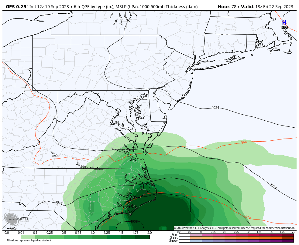
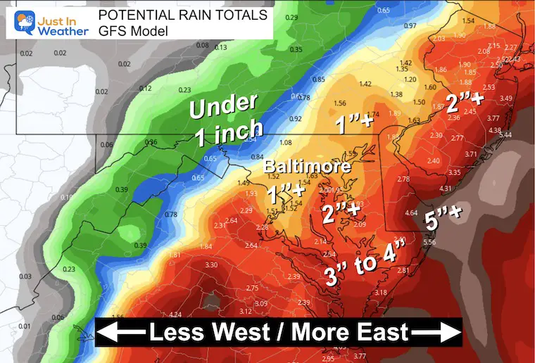
Potential Rainfall
This is from the same model I showed in my prior report. The trend has expanded some of the rain farther west AND increased the heavy rain totals.
Much of our region may end up in the 1 to 2 inches or more.
Higher amounts in Southern Maryland with up to 4 inches and perhaps even over 5 inches on the coast.
Lower amounts in the mountains with likely less than one inch.
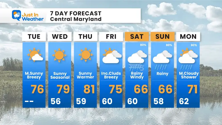
Extended Forecast
This is from my morning report. I did increase the chance for weekend rain and lowered the temps.
New Reports:
Subscribe for eMail Alerts
EARLIER IN AUGUST: Maryland Trek 10 For These Kids
I will have a follow-up and recap on our amazing week shortly.


Please share your thoughts and best weather pics/videos, or just keep in touch via social media
RESTATING MY MESSAGE ABOUT DYSLEXIA
I am aware there are some spelling and grammar typos and occasional other glitches. I take responsibility for my mistakes and even the computer glitches I may miss. I have made a few public statements over the years, but if you are new here, you may have missed it: I have dyslexia and found out during my second year at Cornell University. It didn’t stop me from getting my meteorology degree and being the first to get the AMS CBM in the Baltimore/Washington region. One of my professors told me that I had made it that far without knowing and to not let it be a crutch going forward. That was Mark Wysocki, and he was absolutely correct! I do miss my mistakes in my own proofreading. The autocorrect spell check on my computer sometimes does an injustice to make it worse. I also can make mistakes in forecasting. No one is perfect at predicting the future. All of the maps and information are accurate. The ‘wordy’ stuff can get sticky. There has been no editor who can check my work when I need it and have it ready to send out in a newsworthy timeline. Barbara Werner is a member of the web team that helps me maintain this site. She has taken it upon herself to edit typos when she is available. That could be AFTER you read this. I accept this and perhaps proves what you read is really from me… It’s part of my charm.
#FITF


