September 4 Record Heat Wave And Relief To End The Week Plus Fireball Videos
September 4, 2023
Labor Day Monday Morning Update
We are in the middle of our strongest heat wave of the year! There are at least 3 more days that will challenge records, then cooling down along with needed rain and storms to end the work week into next weekend.
Record Broken In One Minute Reading
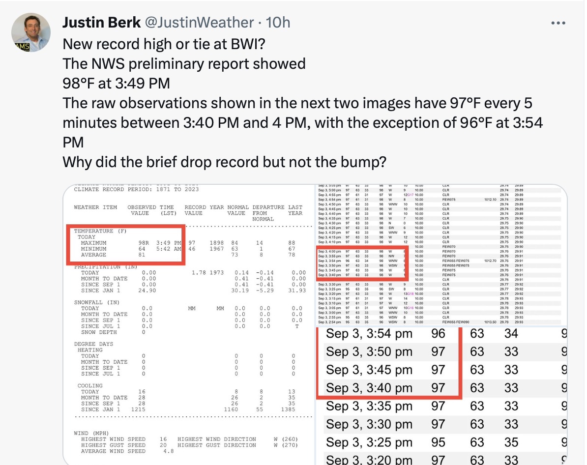
I had a conversation with the National Weather Service on X (formerly Twitter) last night. The 5-minute observations online never showed the temperature above 97ºF, but they reported breaking the record high at BWI with 98ºF at 3:49 PM. It turns out only 1 minute is needed to break the 125 year old record set in 1898 and it appears to be tied for 2 hours between 3 PM and 5 PM.
X has stopped the ability to embed ‘tweets’ so here is my screenshot if you want to see my feed. I will post this on my Facebook page later this morning.
More records are likely over the next few days and I want to add some context:
Record Highs For Baltimore
These are numbers that may be challenged this week. I believe we have a chance to tie or break new records through Wednesday. That would make 4 days in a row!
(Sun) Sept 3 = 97ºF in 1898 – Broken with 1 minute at 98ºF
(Mon) Sept 4 = 96ºF in 2019
(Tue) Sept 5 = 96ºF in 1954
(Wed) Sept 6 = 98ºF in 1983
—— Expected Cooling This Week——
(Thu) Sept 7 = 101ºF in 1881
(Fri) Sept 8 = 100ºF in 1939
Historical Perspective
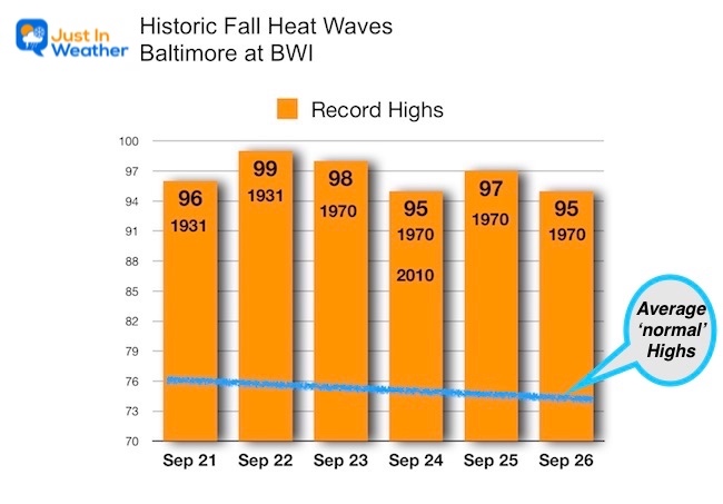
Before the sensationalism you may hear this week, a long-duration record heat wave has happened before.
Here are the late September records for Baltimore. In 1931, there were two records for the 21st and 22nd, which were the 3rd records that year/month.
1970: September 23 to 26 had 4 days with record highs. The 24th was tied in 2010 and may be the one that shows up on some apps/news reports.
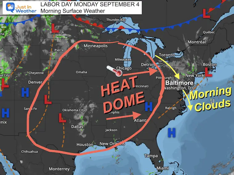
Morning Surface Weather
High Pressure remains in control, but with the high heat, we have relatively low humidity, which is why we have not seen any heat advisories in place.
We do see the influence of upper-level winds carrying clouds at higher levels from the North. This may limit the early day heating, but expect the sun to return this afternoon.
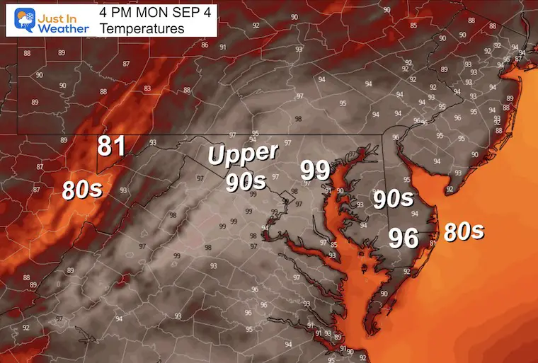
Afternoon Forecast
Here comes the heat! The record high in Baltimore was 96ºF in 2019. We have a good chance to tie or break that at BWI today.
Fireball Last Night
There were hundreds of reports of a blue/green light streaking across the sky, followed by a loud boom. Here is a collection of videos people sent me.
CLIMATE DATA: Baltimore
TODAY September 4
Sunrise at 6:38 AM
Sunset at 7:33 PM
Normal Low in Baltimore: 63ºF
Record 50ºF in 1872 AND 1997
Normal High in Baltimore: 84ºF
Record 96ºF 1937 AND 2019
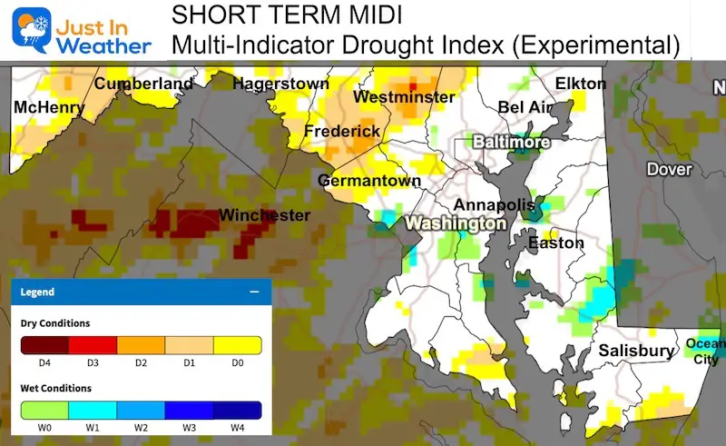
Drought Update
Click the image to see the full report, including Maryland, Pennsylvania, Virginia, and West Virginia.
Subscribe for eMail Alerts
Weather posts straight to your inbox
Sign up and be the first to know!
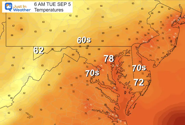
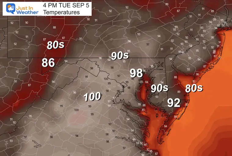
Tuesday Temperature Forecast
Morning
Afternoon
Jet Stream: Monday to Saturday
The break down of the heat wave later this week.
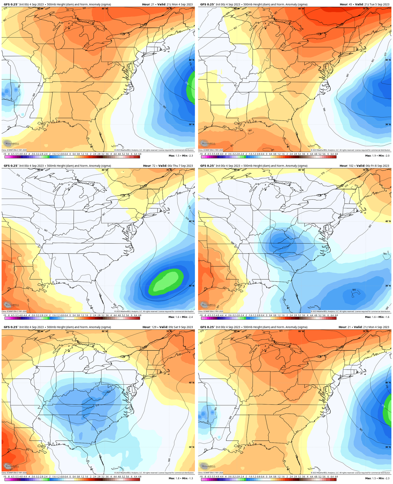
Snapshot Saturday
An upper-level Low will bring in cooler and unstable air. This will help to produce showers and thunderstorms for a few days. Remember, we need the rain!

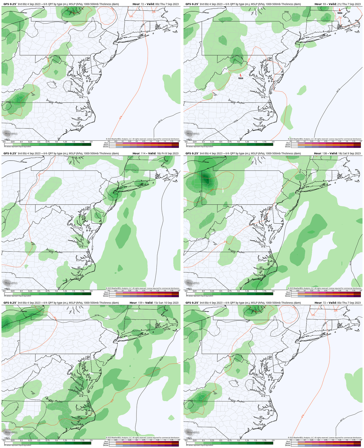
Rain Forecast Wednesday To Sunday
The flare-up of daily thunderstorms will become more numerous each afternoon into the weekend.
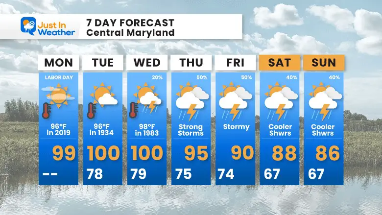
7-Day Forecast
We have a chance to tie or break a record high through Wednesday.
That may break with strong storms, followed by a few days of a stalled pattern with more showers and storms that will help bring the return of cooler weather.
EXPLORE MORE
2023 Hurricane Season Forecast With An El Niño Watch
EARLIER THIS MONTH: Maryland Trek 10 For These Kids
I will have a follow-up and recap on our amazing week shortly.
Subscribe for eMail Alerts
Weather posts straight to your inbox
Sign up and be the first to know!
La Niña Has Ended. El Niño May Return By Fall
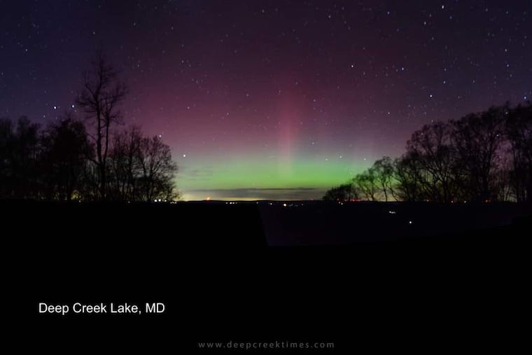
Aurora Photos From Maryland, Delaware, and Virginia
Please share your thoughts and best weather pics/videos, or just keep in touch via social media
-
Facebook: Justin Berk, Meteorologist
-
Twitter
-
Instagram
RESTATING MY MESSAGE ABOUT DYSLEXIA
I am aware there are some spelling and grammar typos and occasional other glitches. I take responsibility for my mistakes and even the computer glitches I may miss. I have made a few public statements over the years, but if you are new here, you may have missed it: I have dyslexia and found out during my second year at Cornell University. It didn’t stop me from getting my meteorology degree and being the first to get the AMS CBM in the Baltimore/Washington region. One of my professors told me that I had made it that far without knowing and to not let it be a crutch going forward. That was Mark Wysocki, and he was absolutely correct! I do miss my mistakes in my own proofreading. The autocorrect spell check on my computer sometimes does an injustice to make it worse. I also can make mistakes in forecasting. No one is perfect at predicting the future. All of the maps and information are accurate. The ‘wordy’ stuff can get sticky. There has been no editor who can check my work when I need it and have it ready to send out in a newsworthy timeline. Barbara Werner is a member of the web team that helps me maintain this site. She has taken it upon herself to edit typos when she is available. That could be AFTER you read this. I accept this and perhaps proves what you read is really from me… It’s part of my charm.
#FITF


