


December 31 Ending The Year With Another Burst Of Wind And Snow Then Cold Start To 2026
Wednesday, December 31, 2025 If I had to ask you for the weather highlight of the year and how it might end, my guess is the majority of people would…
July 2, 2023
Sunday Morning Update
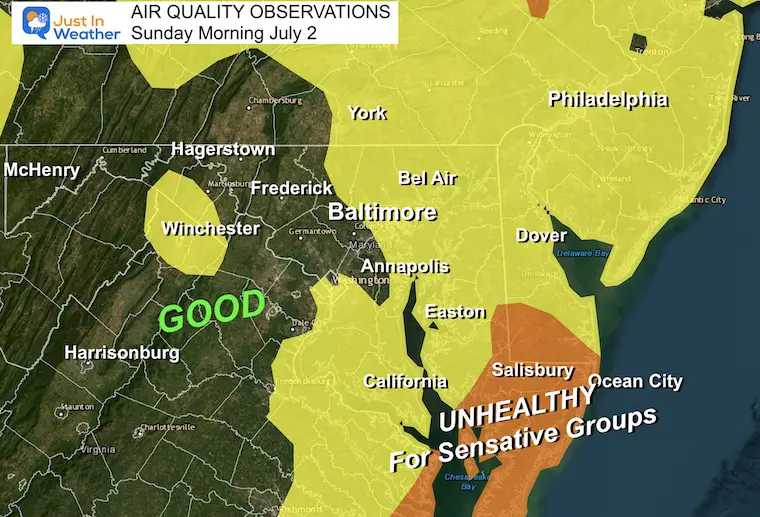
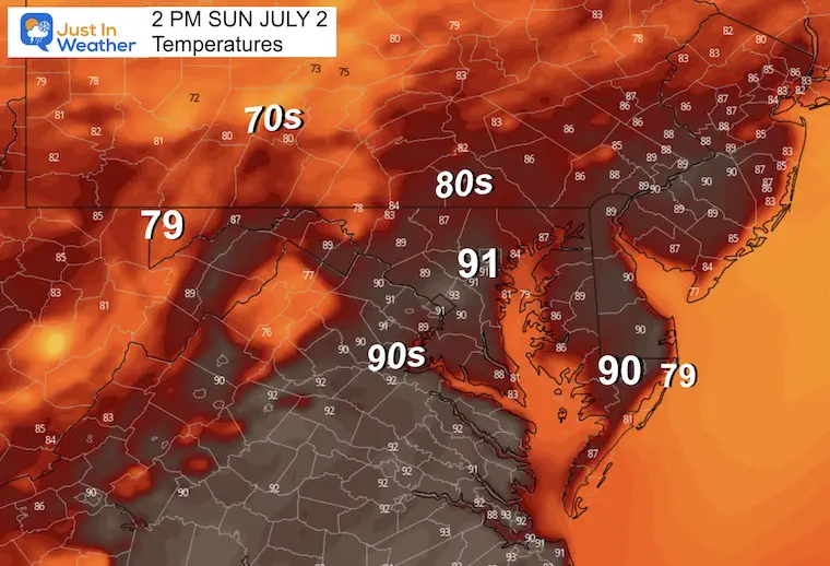
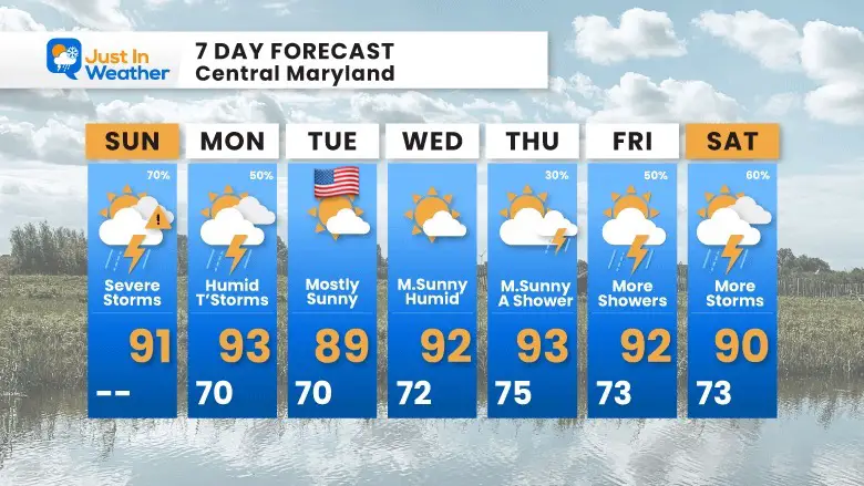
The typical summer warmth and sticky humidity has returned in time for the holiday. This has helped to shift the smoke away and improve our air quality. It will also work to develop strong thunderstorms this afternoon with a risk of severe weather east of the mountains, across the cities, Chesapeake Bay, and to the beaches by this evening.
There is still a pocket of poor air quality on the Lower Eastern Shore of Maryland. However, we have a marked improvement with Good Air moving in from the mountains. This will spread across Delmarva today.
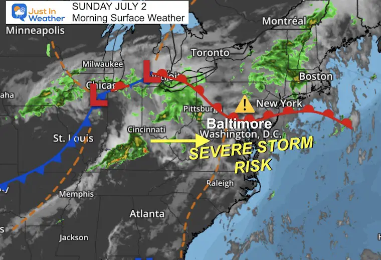
The warm front in southern Pennsylvania may be a focal point for rain today. As humid air settles in much of our area, some energy from the Midwest will work on this to ignite thunderstorms that may turn severe. The most likely timing is between 2 PM and 8 PM.
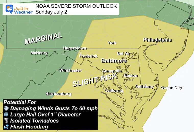
The ‘Slight Risk’ in yellow may be confusing. This area will get widespread showers and storms with an increased risk for some to turn severe.
A storm is considered SEVERE if it contains:
NOTE: Any thunderstorm can contain dangerous lightning. The most dangerous time is before the first drop of rain, so best to get inside before you get wet.
The timing will be AFTER 2 PM in this area. The radar simulation below helps identify locations that may be close to you… It will be earlier west, and later on the Eastern Shore.
Note: There could be a few waves of storms, so it may not be one-and-done.
A Watch may be issued for a broad area. This extends for 6 hours and means there is potential but not a promise.
A Warning is issued when there is a storm with the conditions listed above. This means a storm is occurring and specific towns in the path are listed.
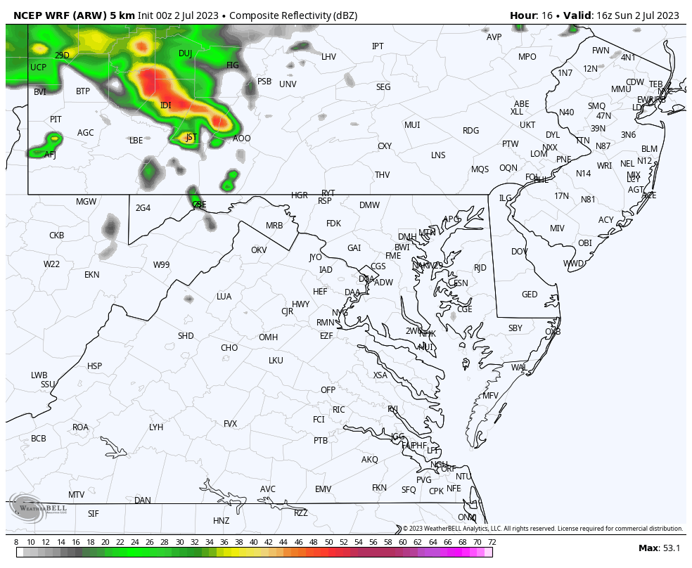
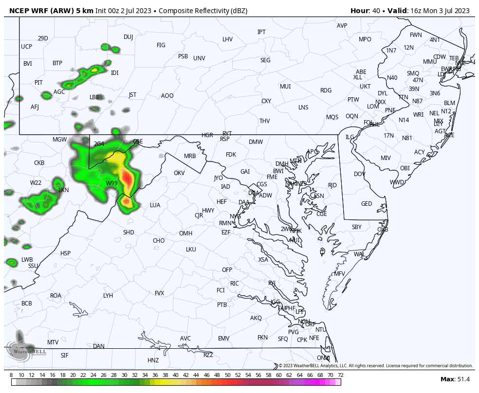
WRF Model: Noon to 10 PM
There will be a flare-up with peak heating mid-afternoon and then storms fade after sunset.
These are suggestions, not perfect! It is best to consider a buffer of one hour earlier or later than shown here.
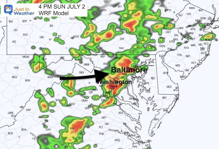
4 PM
This may be prime time in central Maryland. The timing is subject to not line up with this model, which is why I am suggesting any time AFTER 2 PM in central Maryland.
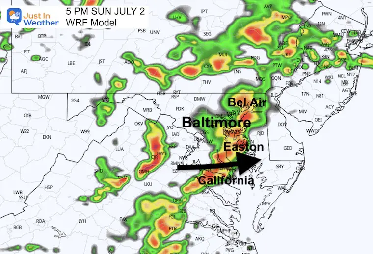
5 PM
There will be widespread storms crossing the Chesapeake Bay, with more across Southern PA and moving out of the Virginia mountains.
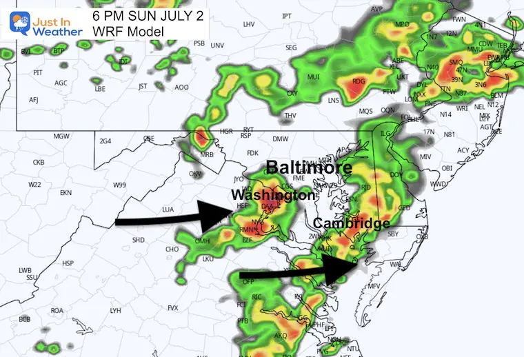
6 PM
The main line moves east across Delmarva while a second storm cluster may be affecting metro Washington.
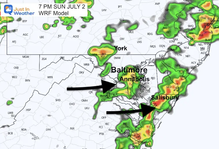
7 PM
A second cluster of storms may reach Baltimore and Annapolis.
The main line will be crossing the Lower Eastern Shore and southern Delaware.
8 PM
Showers will be fading, while the strongest cluster should be reaching the beaches.

If you are at the pool or BBQ, please pay attention to the storms and have easy access to get indoors for safety.
Sign up and be the first to know!
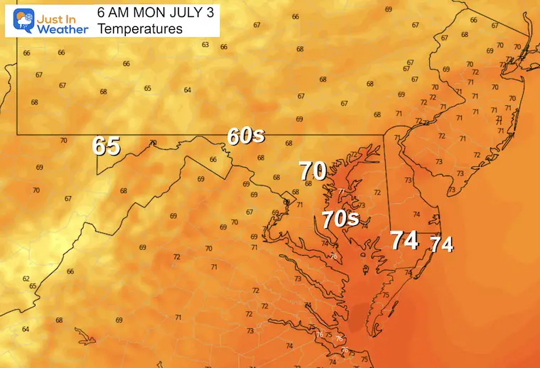
Normal Low in Baltimore: 67ºF
Record 51ºF in 2001
Normal High in Baltimore: 89ºF
Record 103ºF 1901
Noon to 8 PM
There may be some more strong thunderstorms in the afternoon. I do not see the widespread severe risk like today, but some of these cells could produce damaging weather.
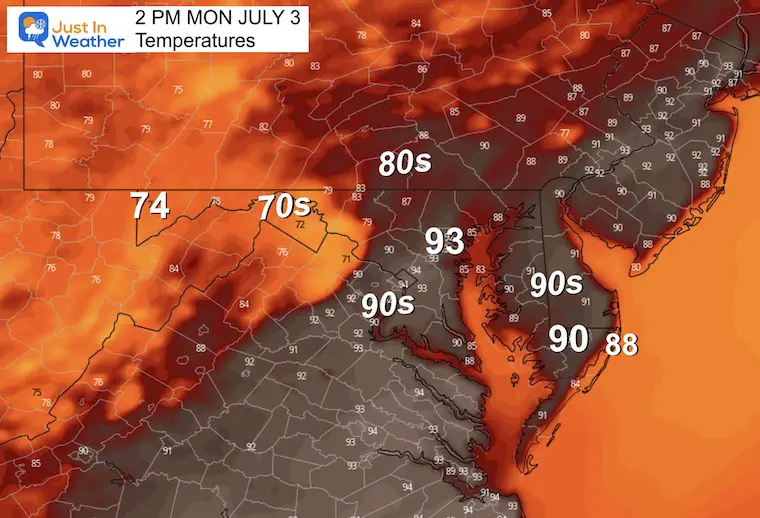
Typical summer weather has settled in. July 4th looks GREAT!
The week ahead spells out a return of heat and humidity. This actually helps keep the wildfire smoke away but will bring some showers and storms back by the end of the week.
Sign up and be the first to know!

I am aware there are some spelling and grammar typos, and occasional other glitches. I take responsibility for my mistakes, and even the computer glitches I may miss. I have made a few public statements over the years, but if you are new here you may have missed it: I have dyslexia, and found out during my second year at Cornell University. It didn’t stop me from getting my meteorology degree, and being first to get the AMS CBM in the Baltimore/Washington region. One of my professors told me that I had made it that far without knowing, and to not let it be a crutch going forward. That was Mark Wysocki and he was absolutely correct! I do miss my mistakes in my own proofreading. The autocorrect spell check on my computer sometimes does an injustice to make it worse. I also can make mistakes in forecasting. No one is perfect predicting the future. All of the maps and information are accurate. The ‘wordy’ stuff can get sticky. There has been no editor that can check my work when I needed it and have it ready to send out in a newsworthy timeline. Barbara Werner is a member of the web team that helps me maintain this site. She has taken it upon herself to edit typos, when she is able. That could be AFTER you read this. I accept this and perhaps proves what you read is really from me… It’s part of my charm.
#FITF