


May 11 Aurora Viewing Forecast Weather And More Photos
Saturday May 11, 2024 The display of Northern Lights last night was historic. As the name implies, this is more common in the Northern Latitudes. On rare occasions we can…
June 28, 2023
Wednesday Morning Update
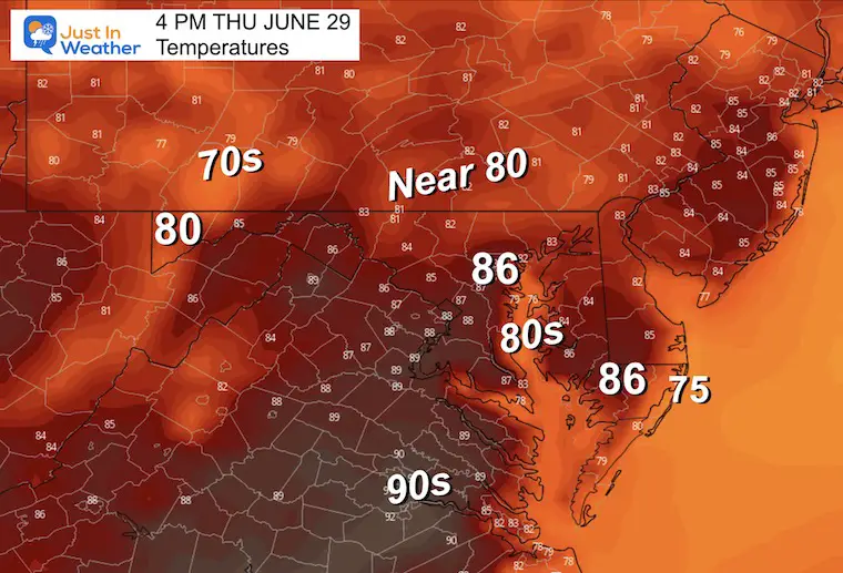
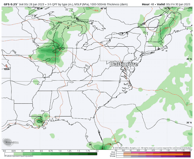
The eruption of widespread storms on Tuesday finally dumped on our official weather station in central Maryland. Baltimore’s BWI recorded 1.77 inches of rain, yet there is still a deficit of 7.46 inches on the year. So we are not out of the drought.
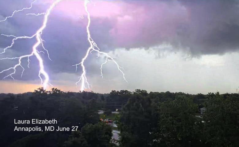
The storms brought large hail, wind damage, and local flooding to parts of the areas.
Today we have a new air mass, but it is tapping into the thick wildfire smoke from Canada and once again bringing that back into our region. We have an air quality alert in place and we will see our sky turn hazy despite it feeling less humid.
There is a lot of information I am sorting through, and realized it was worthy of its own report. So I will post that later this morning.
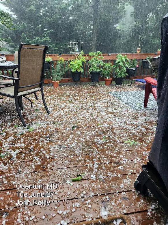
However, I wanted to share a few images here to highlight the storm that hit central Maryland.
Some areas received over 3 inches of rain, and lightning led to some structural fires. But not all areas got hit. Many still remained very dry. I will highlight that later.
Thanks to Laura Elizabeth, who took this photo with an iPhone.
This storm brought hail over 1 inch in diameter to Anne Arundel County. John Reilly captured this image.
I posted this on my Facebook page last night. I will have a full report on this event later.
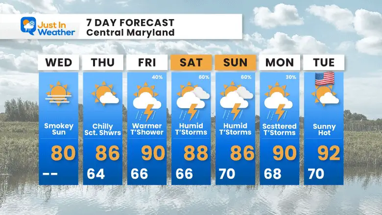
Low Pressure is moving to the east and taking our stormy weather with it. Under normal conditions that would bring us nice weather, and it will feel cooler with lower humidity.
However, smoke from the Canadian Wild Fires will flow back in. Yesterday, Chicago had the worst air quality of any city on the planet. While the thickest smoke will remain in the Midwest, we will get some of it today.
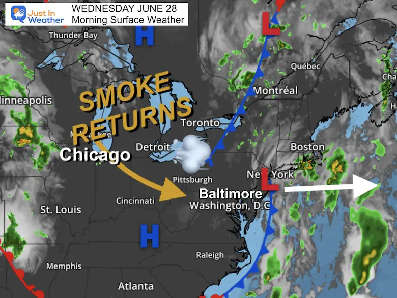
A plume of smoke will float by today and turn our sky milky white again. This is forecast to improve a little tomorrow.
The smoke will increase during the afternoon. We may get that smell returning later this afternoon as well.
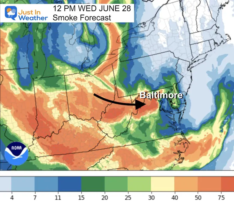
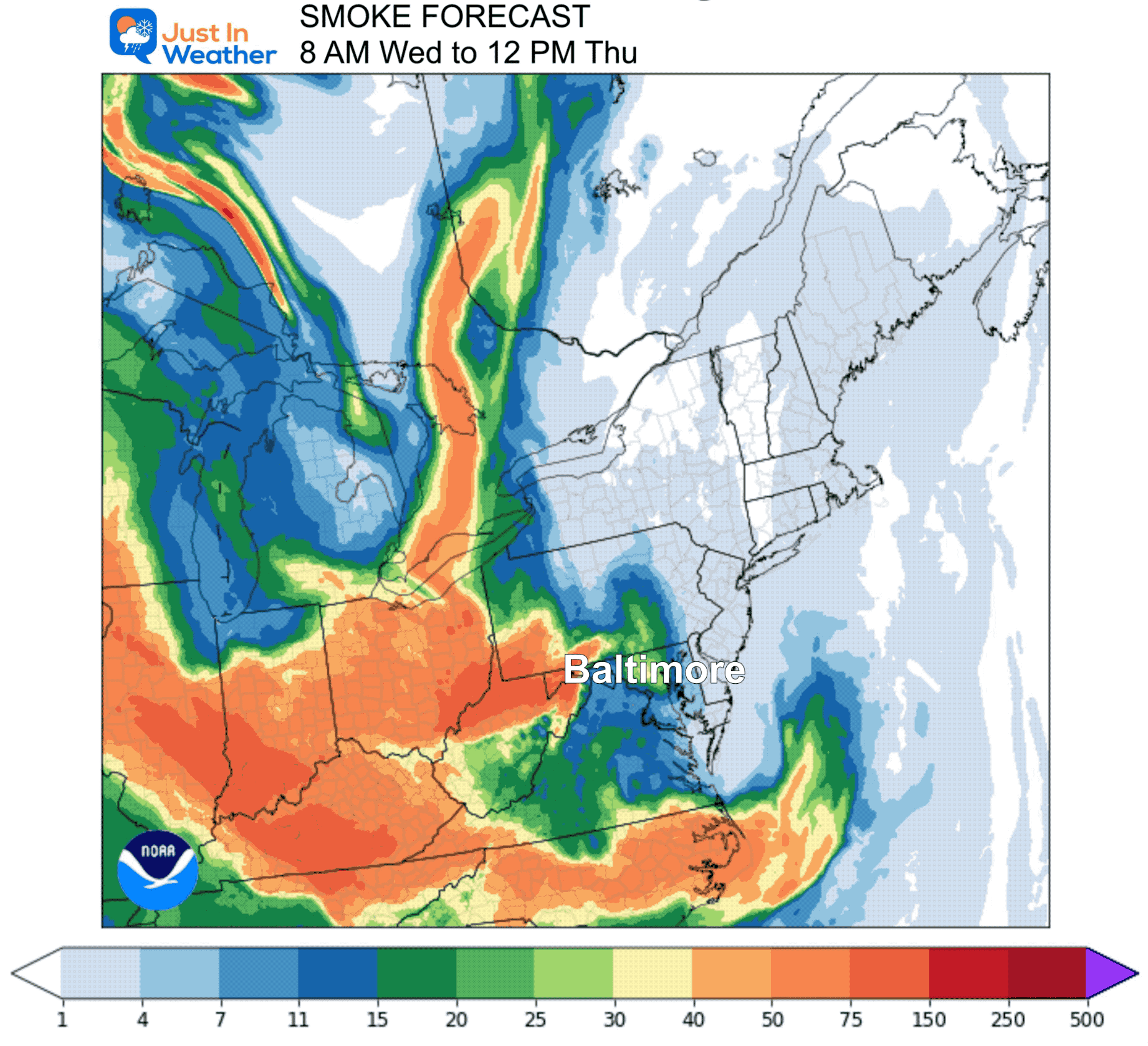
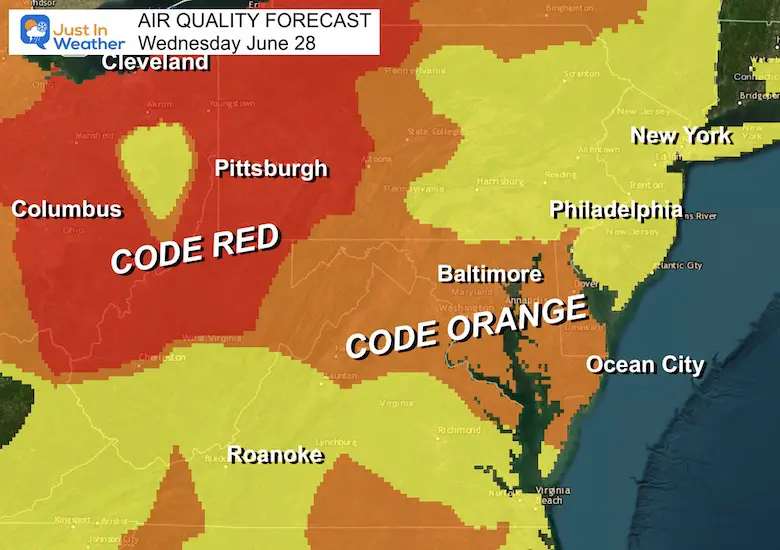
Note the RED in Western Pennsylvania and Ohio: That is Dangerous.
Code Orange means unhealthy for sensitive groups. It is recommended to limit outdoor activities mid-day and this afternoon.
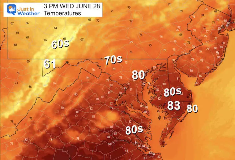
It will be more comfortable and less humid. But like earlier this month, the sky will look hazy and may give the perception that it is humid.
Normal Low in Baltimore: 66ºF
Record 51ºF in 2017
Normal High in Baltimore: 88ºF
Record 99ºF 2010
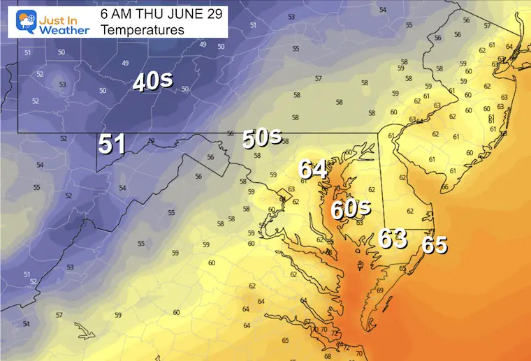
A comfortably cool morning. Metro areas, around the Bay and to the beaches will be in the 60s, but 50s inland and even 40s back in western PA.
The nicest day of the week. Comfortable humidity, less smoke, and remaining dry.
After a nice and dry day, Friday will bring in more heat and humidity. The risk of thundershowers will be late in the day, which could affect holiday travel.
This weekend will be more humid and stormy, but there will be dry hours so not a washout. The pulsing of storms each afternoon will last through Monday. As of now, July 4th may bring back a more stable and less stormy environment.
Thursday and most of Friday look good. There will be some storms returning late Friday and it will be more active this weekend. Summer heat will be returning with more humidity (as expected) through July 4th.

I am aware there are some spelling and grammar typos, and occasional other glitches. I take responsibility for my mistakes, and even the computer glitches I may miss. I have made a few public statements over the years, but if you are new here you may have missed it: I have dyslexia, and found out during my second year at Cornell University. It didn’t stop me from getting my meteorology degree, and being first to get the AMS CBM in the Baltimore/Washington region. One of my professors told me that I had made it that far without knowing, and to not let it be a crutch going forward. That was Mark Wysocki and he was absolutely correct! I do miss my mistakes in my own proofreading. The autocorrect spell check on my computer sometimes does an injustice to make it worse. I also can make mistakes in forecasting. No one is perfect predicting the future. All of the maps and information are accurate. The ‘wordy’ stuff can get sticky. There has been no editor that can check my work when I needed it and have it ready to send out in a newsworthy timeline. Barbara Werner is a member of the web team that helps me maintain this site. She has taken it upon herself to edit typos, when she is able. That could be AFTER you read this. I accept this and perhaps proves what you read is really from me… It’s part of my charm.
#FITF