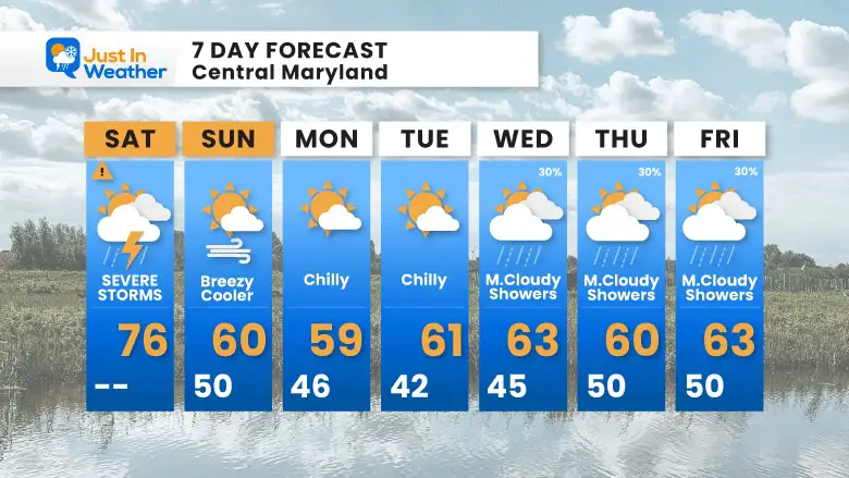
Today will bring an abrupt end to our pre-summer heat and put a full spectrum of weather on display for this Earth Day. If you have outdoor plans, plan to take the risk for severe storms seriously. There will be widespread thunderstorms mid to late afternoon and evening. Any storm could produce dangerous lightning. Some severe cells could bring damaging winds and even isolated tornadoes.
My concern is a Mesolow forming on the cold front, which can enhance the local spin and elevate storms to supercells.
The best suggestion is to prepare for any tine after 2 PM in central Maryland. After 4 PM on Delmarva.
Many questions include the Orioles Game. I have two radar simulations below for you to compare to that or your event and location. Storms will arrive and may be followed by a few hours of rain.
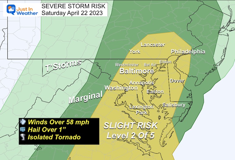
NOAA Severe Storm Risk
The Slight Risk (Level 2 of 5) region has been expanded North of Baltimore into southern Pennsylvania.
Any storm could but is not guaranteed to produce winds over 58 mph, large hail, and isolated tornadoes.
STORM ALERT REMINDER
Later today we may get severe weather alerts. They may include:
Watch: Larger Area; MIGHT HAPPEN
Warning: County Wide; Local Towns Listed; ACTUALLY HAPPENING AND BEING TRACKED
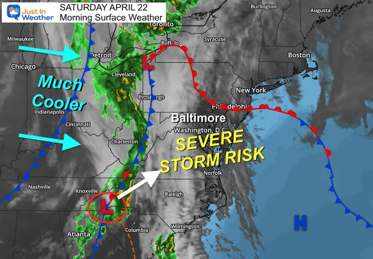
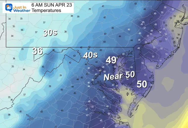
Morning Surface Weather
The cold front is just west of Maryland. Watch the Low Pressure on the front. That may encourage more spin and the Mesolow I mentioned could enhance storms to reach supercell status. Quick spin up tornadoes are possible mid to late afternoon.
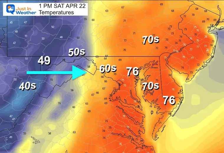
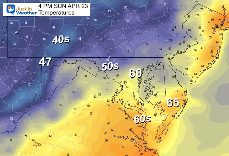
Temperature Forecast
High will occur early, then a dramatic drop behind the front.
1 PM
Central Maryland to Delmarva should reach the 70s, before the big drop!
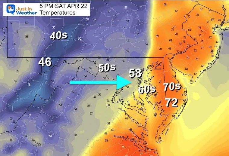
5 PM
A drop from the 70s to 50s in metro areas. If you are heading out, bring a hoodie or jacket.
Lightning Forecast 2 PM to 10 PM
This product shows the electrical activity. I want to highlight the threat for lightning strikes, which can be more dangerous: BEFORE THE FIRST DROP OF RAIN and EVEN WITHOUT A STORM BEING SEVERE.
Radar Simulations
We will compare 2 High Resolution Products for timing and location. Below each animation there is a slider with hourly snapshots. I have also placed the live radar widget below to compare, if you check back here before my next report.
HRRR Model 12 PM to 10 PM
This is the faster/earlier solution
Timeline —> slider 2 PM to 10 PM
Later frames skipped to show Eastern Shore Impact.
april-22-weather-storm-radar-hrrr-pm-2
april-22-weather-storm-radar-hrrr-pm-3
april-22-weather-storm-radar-hrrr-pm-4
april-22-weather-storm-radar-hrrr-pm-5
april-22-weather-storm-radar-hrrr-pm-6
april-22-weather-storm-radar-hrrr-pm-9
april-22-weather-storm-radar-hrrr-pm-10
NAM 3 Km Model 12 PM to 12 AM
This is a little later solution.
Timeline —> slider 3 PM to 7 PM
april-22-weather-radar-severe-storm-nam-pm-3
april-22-weather-radar-severe-storm-nam-pm-4
april-22-weather-radar-severe-storm-nam-pm-5
april-22-weather-radar-severe-storm-nam-pm-6
april-22-weather-radar-severe-storm-nam-pm-7
Live Radar Widget
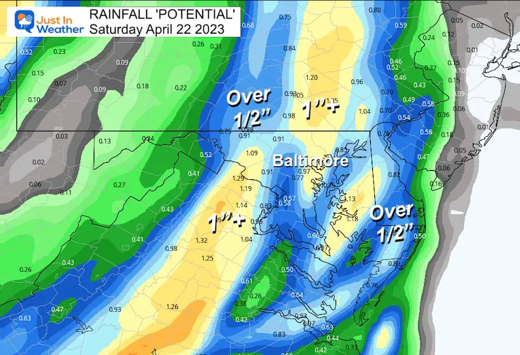
Rain Forecast
We do have a drought building in our region. The potential rainfall today will be close to 1 inch in many areas. Depending on the track and duration of individual storm cells, the local results can be more or less.
I am aware there are some spelling and grammar typos, and occasional other glitches. I take responsibility for my mistakes, and even the computer glitches I may miss. I have made a few public statements over the years, but if you are new here you may have missed it:I have dyslexia, and found out during my second year at Cornell University. It didn’t stop me from getting my meteorology degree, and being first to get the AMS CBM in the Baltimore/Washington region. One of my professors told me that I had made it that far without knowing, and to not let it be a crutch going forward. That was Mark Wysocki and he was absolutely correct!I do miss my mistakes in my own proofreading. The autocorrect spell check on my computer sometimes does an injustice to make it worse. I also can make mistakes in forecasting. No one is perfect predicting the future.All of the maps and information are accurate. The ‘wordy’ stuff can get sticky. There has been no editor that can check my work when I needed it and have it ready to send out in a newsworthy timeline. Barbara Werner is a member of the web team that helps me maintain this site. She has taken it upon herself to edit typos, when she is able. That could be AFTER you read this.I accept this and perhaps proves what you read is really from me…It’s part of my charm.