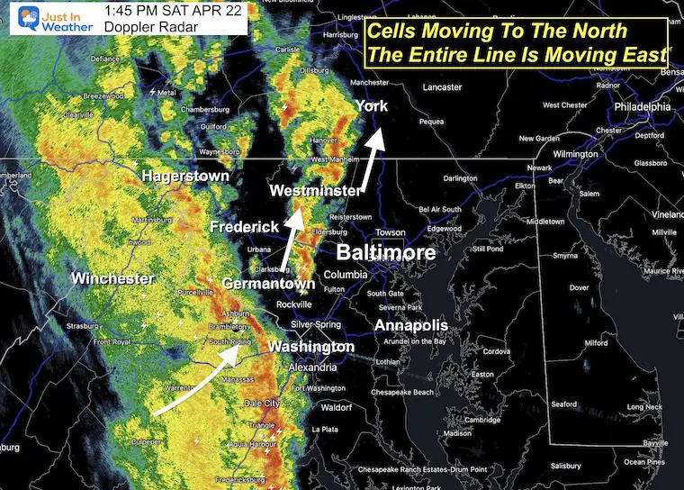
The cold front is on the move and has produced cells a little earlier than expected. The main line of potentially severe weather has also shown to be farther east than the morning model guidance.
The main story here is that we have an environment conducive for storms to turn severe, and for an extended period of rainfall. If you are planning to go to the Orioles Game in Baltimore, there is a good chance for a delay, and favorable to possibly postpone. I do NOT make the call, but that is the advice I gave family and friends. So be aware, and if you do go, it will turn chilly in a hurry.
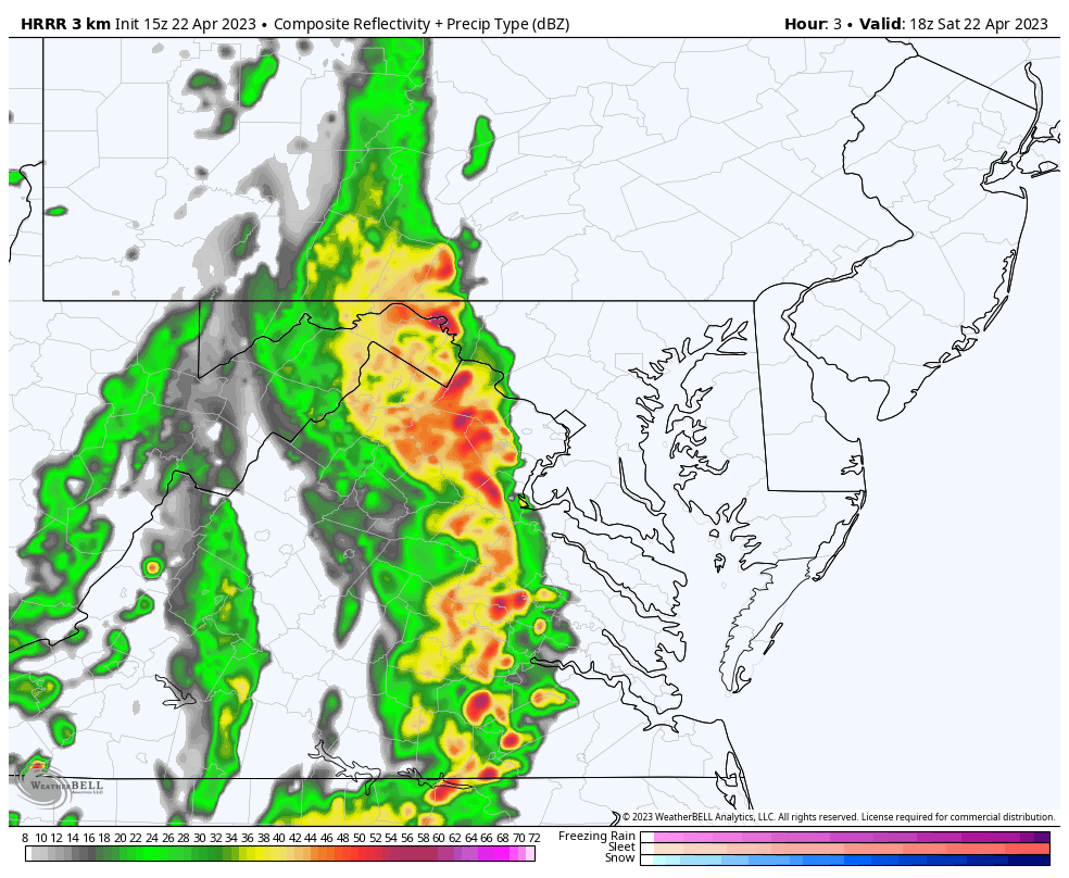
Radar Snapshot at 1:45 PM
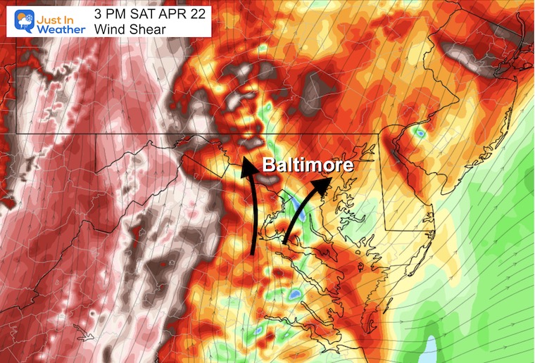
The risk for severe storms is based on wind shear turning aloft. This can enhance rotation that can produce damaging wind, large hail, and even tornadoes.
The individual cells are moving to the North/Northeast, while the entire line is moving to the East.
I am already seeing some Meso-Low style spin along the main line west of Washington. Watch out in central Maryland for this to swing through with peak impact between 2 PM and 5 PM.
Compare to the forecast simulation AND Live Radar with Lightning Widget below.
We may see multiple lines of storms, with bow echos on radar indicating a strong gusty front with damaging winds. The rotation may produce isolated tornadoes.
While we have a region-wide Watch for the potential of storms to turn severe, it is not a promise. If and when you see a Warning, then a severe storm is active and being tracked through specific towns and counties.
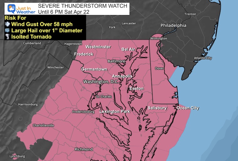
Severe Thunderstorm Watch Until6PM
This starts at the Maryland line with PA and includes most places south and east. While PA is not in this initial Watch, they could still be included for severe storms later.
Winds over 58 mph
Hail over 1 inch diameter
Isolated Tornadoes
Flash Flooding
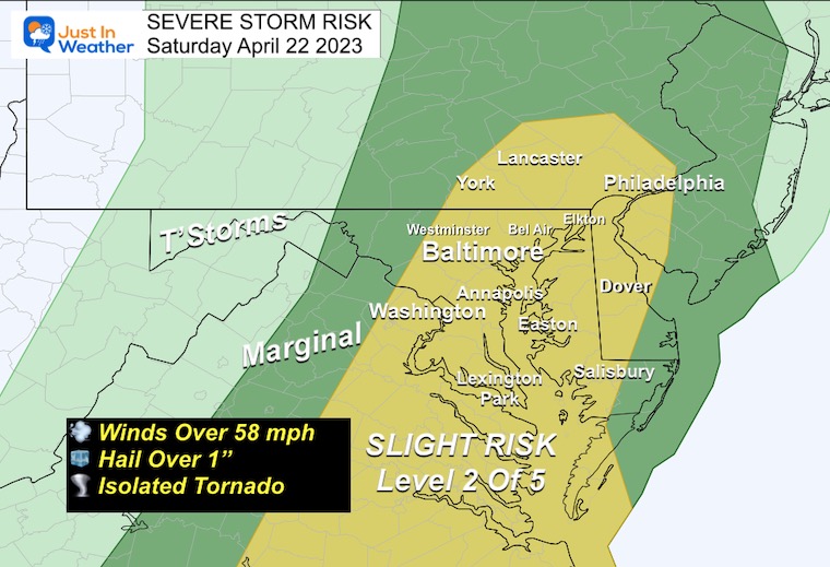
NOAA Severe Thunderstorm Risk From This Morning
This extends farther north than the current Watch issued, so in PA keep a heads up for nasty storms and new alerts your way as well.
Winds over 58 mph
Hail over 1 inch diameter
Isolated Tornadoes
Flash Flooding
Wind Shear
This is a measure of the change in wind direction with height. The backing shift aloft is what helps storms twist, circulate, and become more severe.
Radar Simulation
2 PM to Midnight HRRR Model
This helps show the movement to the east, but individual cells will be moving south to north along the line.
The change in wind direction is the wind shear, adding to potential spin to produce damaging winds or isolated tornadoes.
The main line crosses metro Baltimore between 3 PM and 5 PM, but the risk for more rain and maybe another line of storms will continue into the evening. See the slider below for individual hour time-frames.
Timeline —-> slider
Please note that this is NOT PERFECT. WE have already seen the rain a little ahead of time. So the chance is that you may see this verify an hour earlier than shown here.
april-22-weather-storm-radar-hrrr-saturday-pm-2
april-22-weather-storm-radar-hrrr-saturday-pm-3
april-22-weather-storm-radar-hrrr-saturday-pm-4
april-22-weather-storm-radar-hrrr-saturday-pm-5
april-22-weather-storm-radar-hrrr-saturday-pm-6
april-22-weather-storm-radar-hrrr-saturday-pm-7
april-22-weather-storm-radar-hrrr-saturday-pm-8
april-22-weather-storm-radar-hrrr-saturday-pm-9
april-22-weather-storm-radar-hrrr-saturday-pm-10
Live Radar Widget
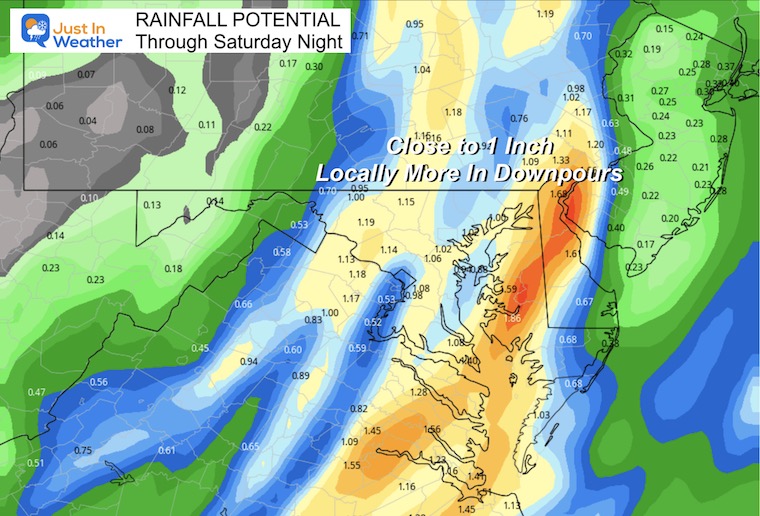
Rainfall Total
The potential is for many areas to possibly get close to 1 inch. This may range from 1/2 inch to over 1.5” depending on where the storm cells line up. No matter what you get, it will be welcomed by your lawn and plants.
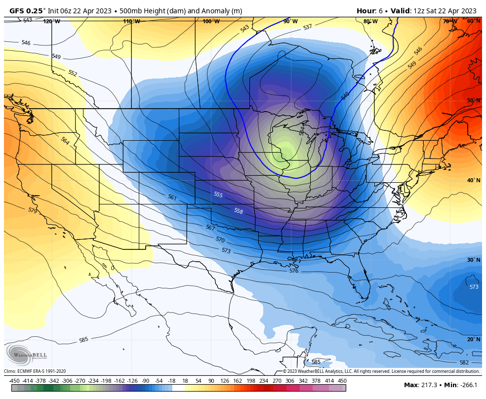
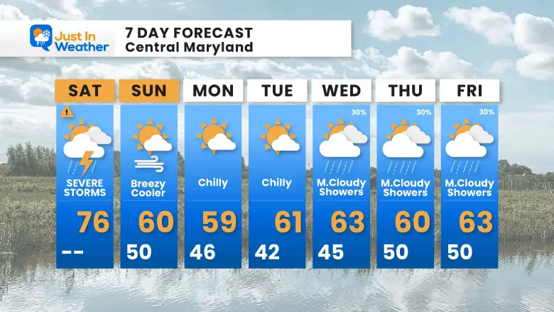
Colder Air To Follow
The jet stream will be flipping to a colder pattern next week and keep our temperatures around 10 degrees below average in the lower 60s.
Looking Ahead: Jet Stream Saturday to Friday
The upper air pattern will be dominated by a cooler air flow. The rest of the month will be cooler than average for the Eastern US.
I am aware there are some spelling and grammar typos, and occasional other glitches. I take responsibility for my mistakes, and even the computer glitches I may miss. I have made a few public statements over the years, but if you are new here you may have missed it:I have dyslexia, and found out during my second year at Cornell University. It didn’t stop me from getting my meteorology degree, and being first to get the AMS CBM in the Baltimore/Washington region. One of my professors told me that I had made it that far without knowing, and to not let it be a crutch going forward. That was Mark Wysocki and he was absolutely correct!I do miss my mistakes in my own proofreading. The autocorrect spell check on my computer sometimes does an injustice to make it worse. I also can make mistakes in forecasting. No one is perfect predicting the future.All of the maps and information are accurate. The ‘wordy’ stuff can get sticky. There has been no editor that can check my work when I needed it and have it ready to send out in a newsworthy timeline. Barbara Werner is a member of the web team that helps me maintain this site. She has taken it upon herself to edit typos, when she is able. That could be AFTER you read this.I accept this and perhaps proves what you read is really from me…It’s part of my charm.