


July 18 Flood Watch In The Mountains Then Storms Expand Back This Weekend
Friday, July 18 2025 Morning Report There is some relief in sight, but I remain cautious. For the short term, today remains muggy, while the focus of strong storms and…
March 13, 2023
Monday Afternoon Update
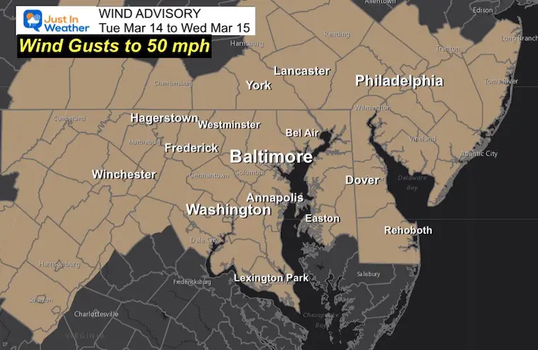
The largest winter storm of the season is now under development. This Nor’easter is going to be a very strong weather event with a large impact across the North East and Mid Atlantic regions. Inland areas will have blizzard conditions. Regardless of where the snow or rain reaches, the wind will be the main player for our region.
The pressure gradient of the new storm will produce increasing winds on Tuesday into Wednesday with gusts up to 50 mph. As a result, a Wind Advisory has been issued in Maryland, Pennyslvania and Delaware.
There is some fluctuation of the timing between the National Weather Service Office Zones, but essentially our entire region will have winds over 30 mph, with gusts to 50 mph. This may produce downed trees and power outages.
8 PM Mon to 8 PM Tue
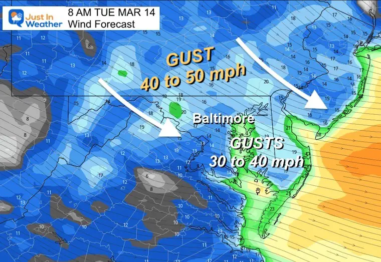
Winds will increase Tuesday morning and remain strong all day!
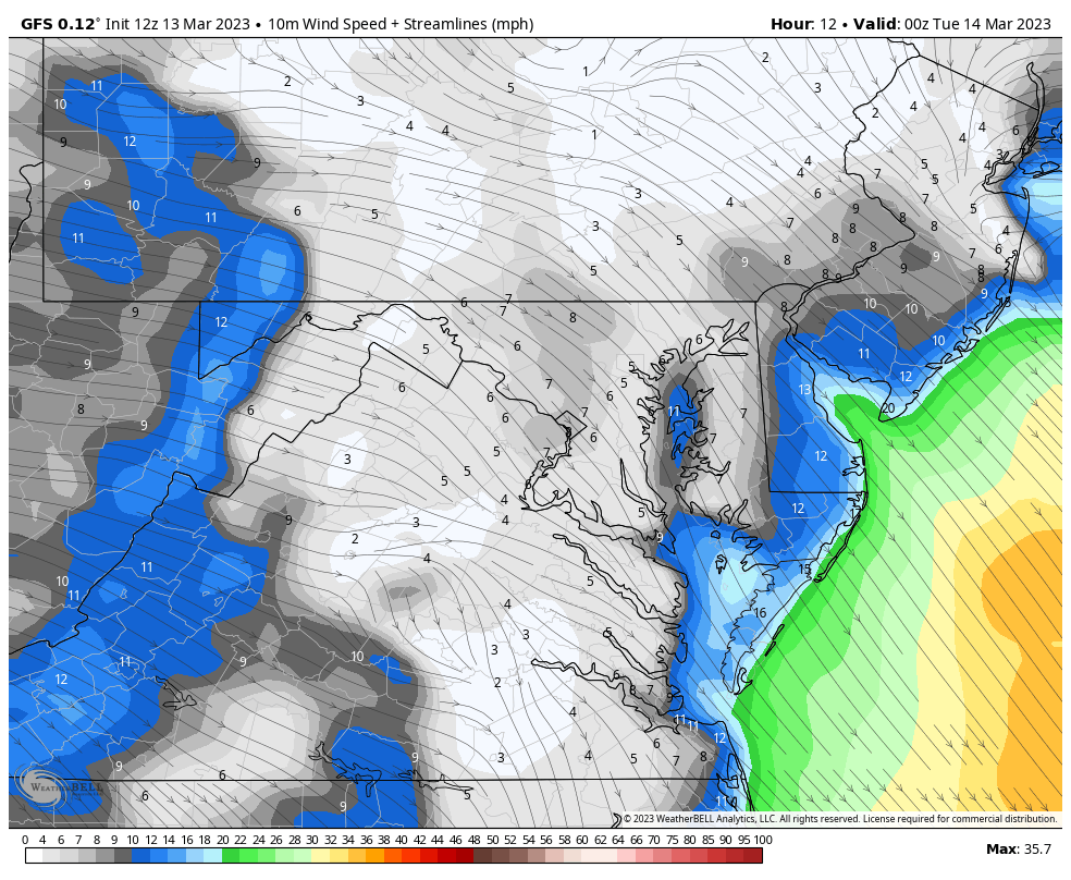
Strong winds from the Northwest will average 20 to 40 mph. Gusts will push close to 50 mph… and last all day!
Low Pressure is located East of Virginia Beach, VA. This is forecast to swing out to the East and Northeast, influenced by Blocking High Pressure in Nova Scotia. That is a key element that may help this pull back West to the Gulf of Maine as it bottoms out!
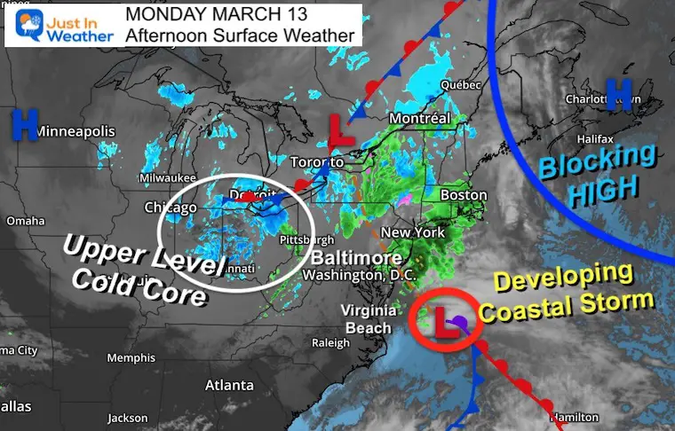
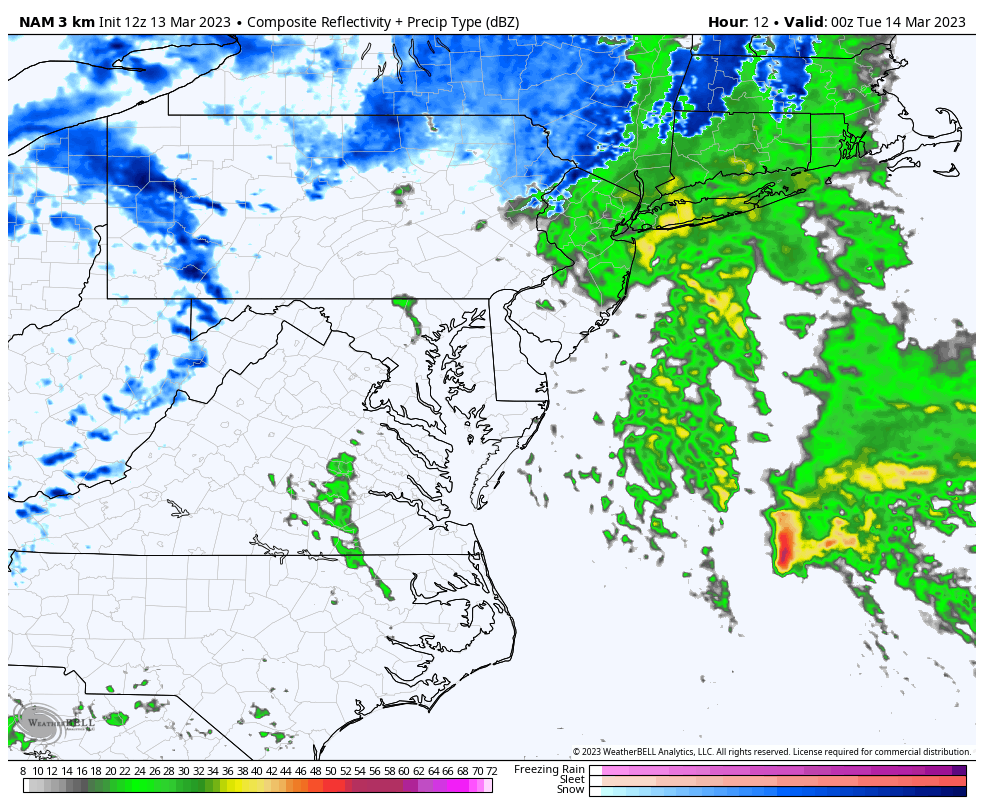
Track the Core Energy passing through southern Pennsylvania on Tuesday morning, then slowing down and nearly stalling for 12 hours just east of Boston.
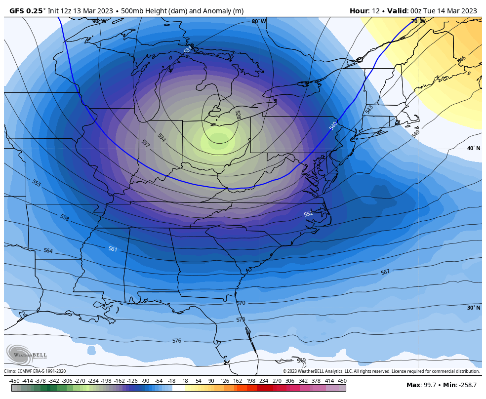
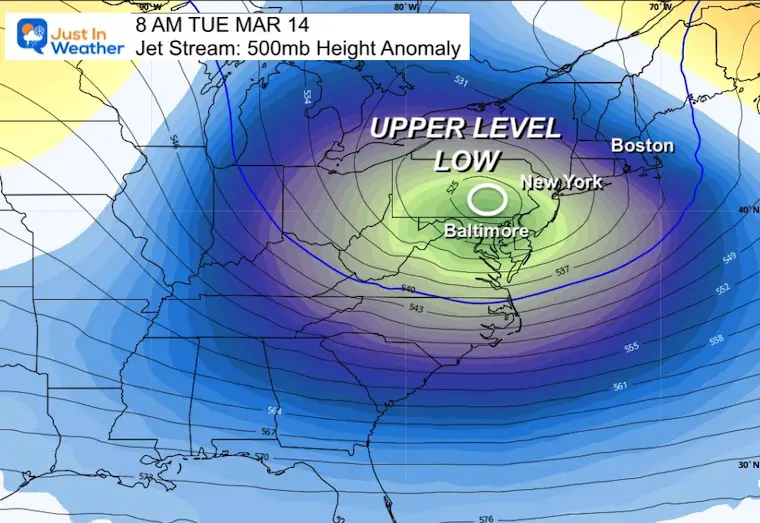
The Upper Level Low will be just north of Baltimore at this time. That is the reason the storm East of Boston is expected to get pulled back west AND have influence of snow showers plus strong winds into Maryland.
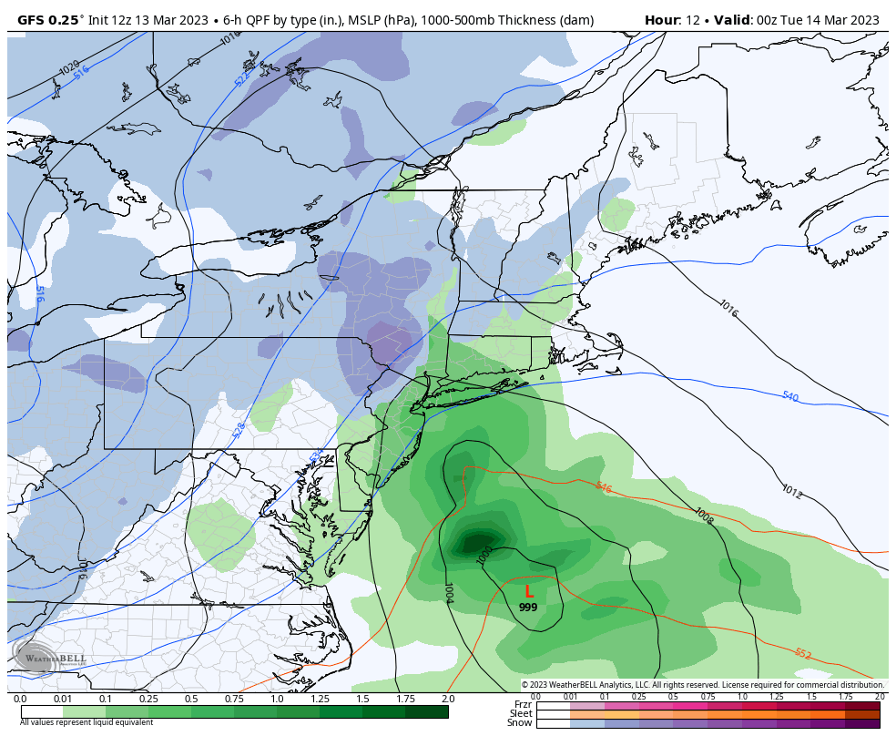
8 PM MON to 8 AM WED – GFS Model
Low Pressure: Watch the wide turn in the Atlantic, then the pull back near Boston. This is in response to the Upper Level closed Low and deep trough.
If this storm nearly stalls or retrogrades farther back to the West, will be the big BUST potential.
Low Pressure EAST of Boston will continue to deepen. The retrograde (pull backward to the WEST) will determine if and when Boston and coastal areas transition from rain to snow. The large influence of this storm will be felt into the Mid Atlantic.
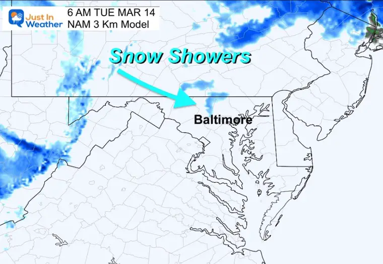
Snow Showers may push into northern Maryland.
Strong Winds will expand through the region to the Mid Atlantic Coast.
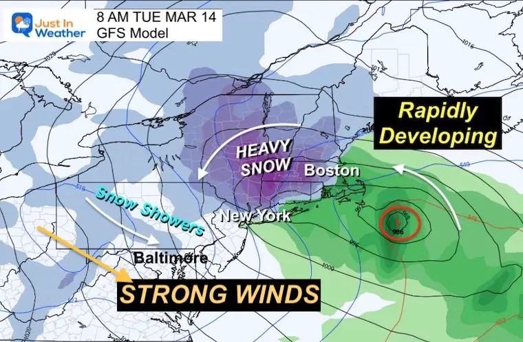
As we watch the storm crank in New England, the back edge will send snow showers or flurries into northern Maryland on Tuesday Morning.
The influence of the core, ‘comma head’, main precipitation will depend on how far west that Retrograde can make it.
This shows agreement with the HRRR Model. Often the flurries expand to more areas than shown on the model… but not expected to be a travel issue.
I will have more detail about the snow part of this storm. I will include snow forecast for the main impact zone and the potential snow showers for our region.
Sign up and be the first to know!
My REALISTIC Expectations for the COLD OUTLOOK
Winter History: Low Snow And Late Starts
See my research based on Baltimore data since 1883.

I am aware there are some spelling and grammar typos, and occasional other glitches. I take responsibility for my mistakes, and even the computer glitches I may miss.
I have made a few public statements over the years, but if you are new here you may have missed it:
I have dyslexia, and found out during my second year at Cornell University. It didn’t stop me from getting my meteorology degree, and being first to get the AMS CBM in the Baltimore/Washington region. One of my professors told me that I had made it that far without knowing, and to not let it be a crutch going forward. That was Mark Wysocki and he was absolutely correct!
I do miss my mistakes in my own proofreading. The autocorrect spell check on my computer sometimes does an injustice to make it worse. I also can make mistakes in forecasting. No one is perfect predicting the future.
All of the maps and information are accurate. The ‘wordy’ stuff can get sticky.
There has been no editor that can check my work when I needed it and have it ready to send out in a newsworthy timeline. Barbara Werner is a member of the web team that helps me maintain this site. She has taken it upon herself to edit typos, when she is able. That could be AFTER you read this.
I accept this and perhaps proves what you read is really from me…
It’s part of my charm.
#FITF
Click to see more and ‘Book’ a visit to your school

I see many factors to support colder influence with multiple systems. Early and later in winter. Check it out. https://justinweather.com/2022/11/22/winter-outlook-2023-for-snow-not-typical-la-nina-plus-polar-vortex-disruption/
September Starts Meteorological Autumn: Weather Climate Stats For Maryland at Baltimore
https://justinweather.com/2022/09/09/winter-outlook-2023-la-nina-triple-dip-expectations/
If you want a snowy winter, this is what you might want to look for in the rest of the tropical season. https://justinweather.com/2022/08/31/record-august-for-no-named-tropical-storms-closer-look-at-snow-following/
https://justinweather.com/2022/10/25/winter-weather-outlook-from-the-wooly-bear-caterpillar/

