February 19 Back To Our Warm Pattern Some Rain And Hint Of Winter Next Weekend
February 19, 2023
Sunday Morning
Here we go again warming things up. This has been a Winter more like a long Autumn, which has helped utility bills but hurt snow lovers. I feel you and know literally anything can happen through March.
The week ahead may get one day near record warmth. Almost a guarantee to see one day in the 70s. Then a hint at snow next weekend. All winter we have seen a phantom storm one week away not materialize, so I will show you what I see on the model plots, but will not get too excited yet until we get a few more days of consistent data.
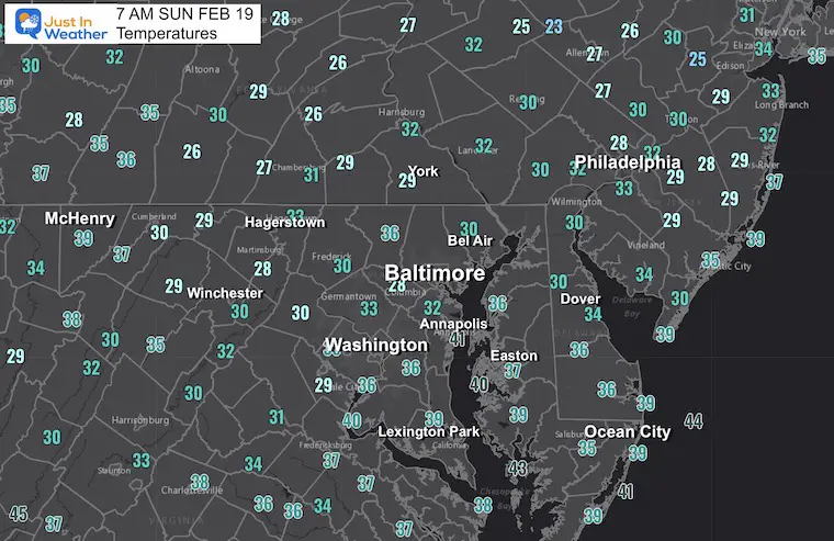
Morning Temperatures
Residual cold air but it will be eroding fast as we get back into our mild pattern.
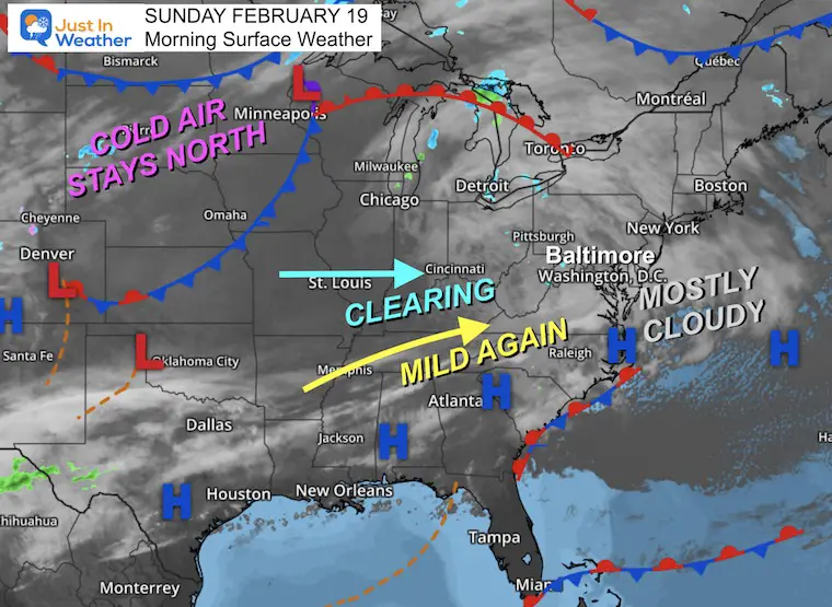
Morning Surface Weather
The satellite shows a cloudy sky, but I’ve witnessed thin clouds with some sunshine over central Maryland already this morning.
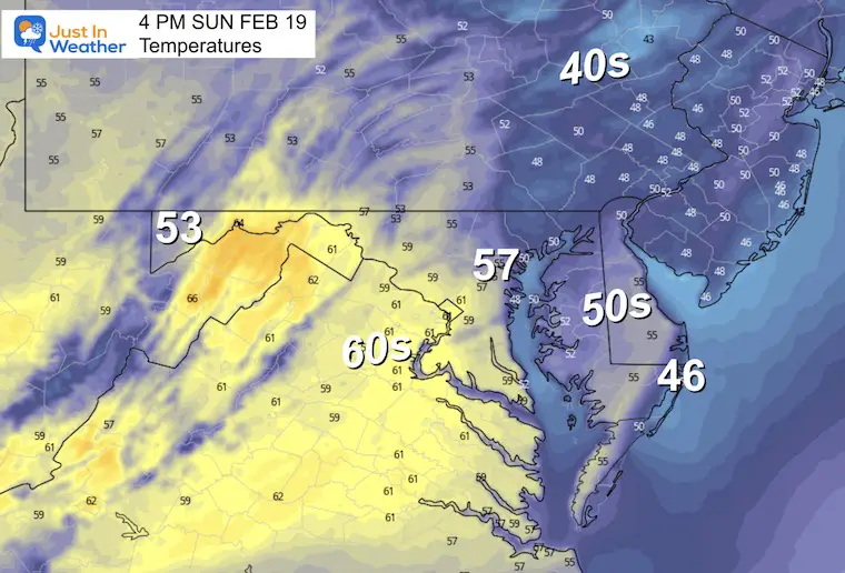
Temperatures Afternoon
A warmer day with temperatures back into the 50s. Areas that may reach the 60s are more likely to the west where sun will break out sooner.
If you get into afternoon sun, your temps may surge higher as well.
Subscribe for eMail Alerts
Weather posts straight to your inbox
Sign up and be the first to know!
CLIMATE DATA
TODAY February 19
Normal Low in Baltimore: 28ºF
Record 5ºF in 1903
SNOW: 5.7” in 16.4″ in 1979
Normal High in Baltimore: 47ºF
Record 72ºF 1997
President’s Day
It doesn’t always snow, and it definitely won’t this year! We may have scattered rain showers with mild temps in the 50s.
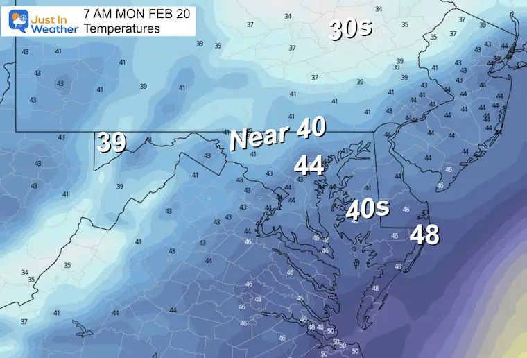
Morning
Most of our region will start the day near or above 40ºF.
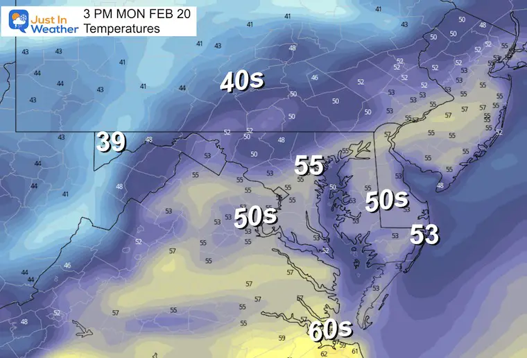
Afternoon
Mild again back into the mid 50s.
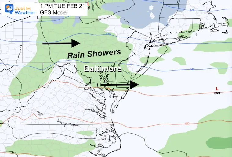
Tuesday Rain?
It may appear worse on your app than it will be. I see scattered showers, not a washout.
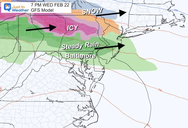
Wednesday Rain
This looks like a more potent system, but for the northern half of our region, north of Baltimore. There will be a period of steady rain, with an icy mix into northern Pennsylvania and a return to snow across central New York. It will bring a winter storm to Northern New England.
Forecast Animation:
Thursday Through Saturday
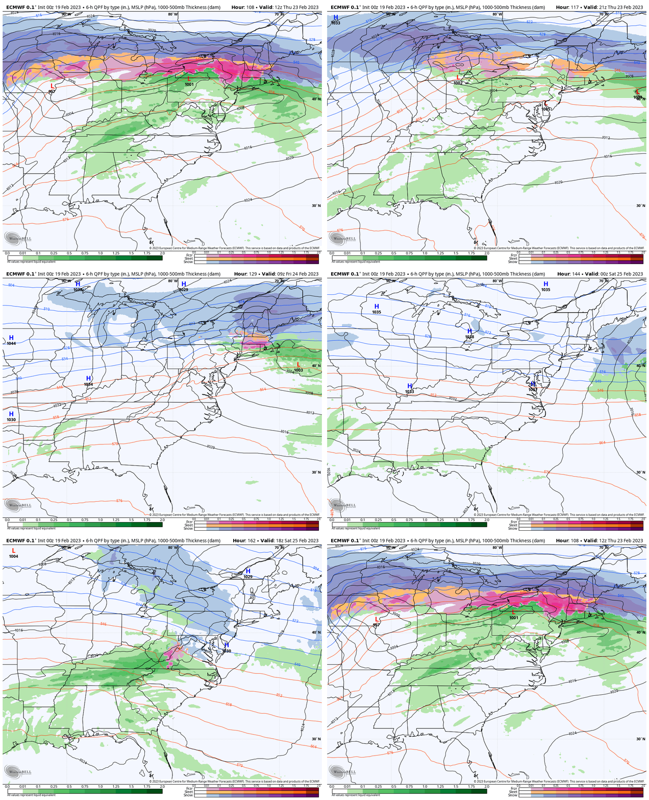
This is the European Model showing rain showers pushing north as very warm air flows in. There will be an impactful icy mix and snow to our north.
The big warm up will be Thursday as temperatures will approach one of the oldest records on the books.
It was 78ºF in 1874 on Feb 23. That is the mark to watch! We often end up higher than models show.
The colder air will actually arrive almost uneventfully Friday, then we will see if that atmosphere will line up the energy on Saturday.
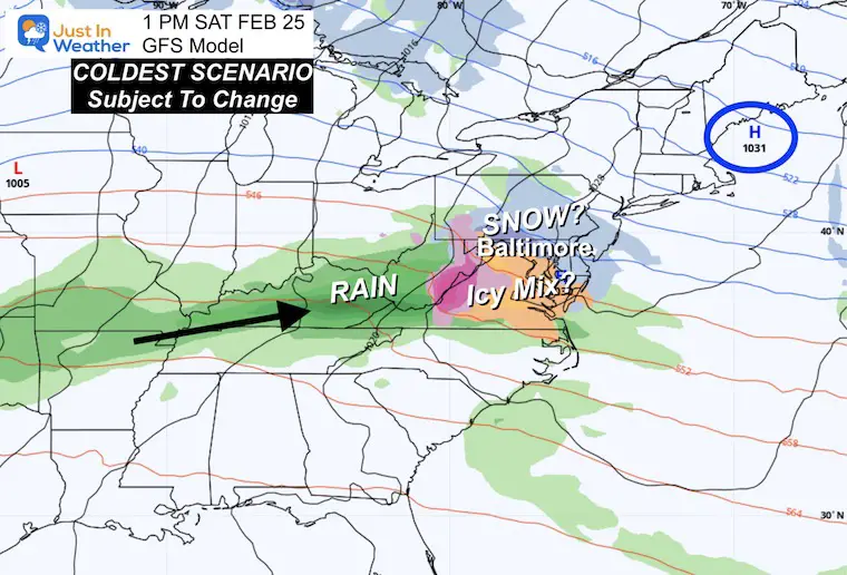
Snow Saturday? I am only following the suggestion now, but need two more days of consistent data before I will take this seriously.
Saturday: GFS Model
This solution is the coldest and most aggressive. I need to remind you that this model has done this all winter and has often failed. Since there is some hint of snow across model guidance, I am showing it to you.
Again, I need two more days of consistency and once we get within 5 days I will consider taking this seriously. If nothing else, this is just hope for winter lovers for something to hang on to.
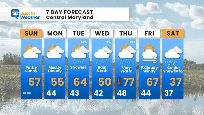
7 Day Forecast
Rain showers this week but NOT a washout. The steadier rain is likely to be on Wednesday and for the northern half of the region.
The colder air will actually arrive almost uneventfully Friday, then we will see if that atmosphere will line up the energy Saturday.
Snow Saturday? I am only following the suggestion now, but need 2 more days of consistent data before I take this seriously.
TRAIN DERAILMENT: TOXIN TRANSPORT
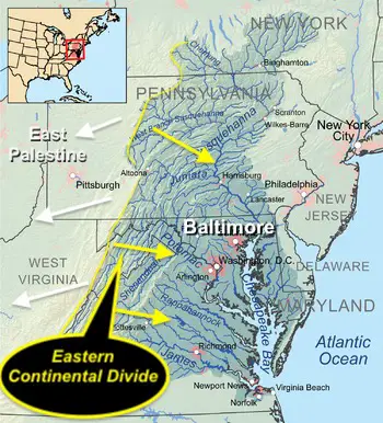
Report: Tracking Winds For Movement from the accident to the Controlled Burn Also see Videos Of Toxins in local water in East Palestine, OH.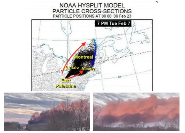
REPORT: Chesapeake Bay and Ohio Watersheds. Please click here for that report if you missed it.
Also See:
Winter History: Low Snow And Late Starts
See my research based on Baltimore data since 1883.
Subscribe for eMail Alerts
Weather posts straight to your inbox
Sign up and be the first to know!
STEM Assemblies/In School Fields Trips Are Back
Click to see more and ‘Book’ a visit to your school
My Winter Outlook: Not A Typical La Niña!
I see many factors to support colder influence with multiple systems. Early and later in winter. Check it out.
Also See The Winter Outlook Series:
Farmer’s Almanac Comparison
September Starts Meteorological Autumn: Weather Climate Stats For Maryland at Baltimore
Triple Dip La Niña Winter
https://justinweather.com/2022/09/09/winter-outlook-2023-la-nina-triple-dip-expectations/
CONNECTION TO WINTER?
If you want a snowy winter, this is what you might want to look for in the rest of the tropical season.
Rainbow Ice Cave In Mt. Rainier A Very Rare Find: Photos And Video
Woolly Bear Caterpillars
https://justinweather.com/2022/10/25/winter-weather-outlook-from-the-wooly-bear-caterpillar/
Persimmon Seeds
Click to see Top 20 and MORE
Normals And Records: Maryland and Baltimore Climate History
Please share your thoughts, best weather pics/videos, or just keep in touch via social media
-
-
Facebook: Justin Berk, Meteorologist
-
Twitter: @JustinWeather
-
Instagram: justinweather
-


