Friday February 17, 2023
This is a follow up to my first report about the weather and water impact due to the train derailment in East Palestine, OH, on February 3, 2023. I have been carefully sorting through the available information to bring you the most accurate information possible.
In this report, we will briefly look at the weather on the dates of the train derailment and the day of the controlled burn. This is simply to see the air flow and weather systems.
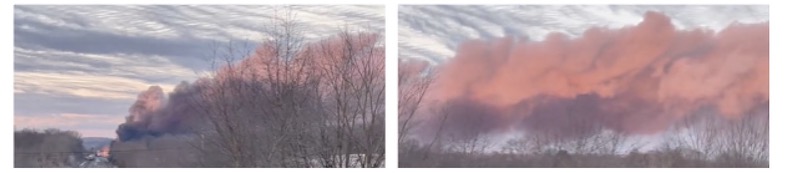
New video I found of the burn (see below) shows how the smoke plume traveled.
The most alarming are the new videos of the chemicals in the local water in East Palestine, OH. There is valid skepticism of anything we see, and I welcome questioning everything. Locals have been questioning authorities about the safety, given the immediate health determination in people and death of wildlife.
I am adding my perspective as a meteorologist, but I have a personal connection to this story.
- I am an environmental scientist, and this has been an impact on the environment.
- My wife and I run the nonprofit Just In Power Kids, providing free services to kids in cancer treatment. I can’t help but make the leap to potential health impacts on local kids and families in East Palestine given the history of chemical spills and burns.
- I experienced the effect of acid rain in the mid 1980s. I attended a summer soccer camp (Idylwold) on Schroon Lake in the northern Adirondacks of New York for three summers. I had just learned about acid rain and personally witnessed dead fish floating to the surface of our swimming area on the lake most times it rained. I know now it was based on the track of the storms and pollution in the air. So watching the videos of dead fish and animals in Ohio brought back a reality for me.
Timeline:
- Feb 3-4: Train Accident/Fire On Norfolk Southern Line
- Feb 6: Controlled Burn
- Feb 15: East Palestine Town Hall. Norfolk Southern and Federal Government did not show (not political, simply a reason locals attended)
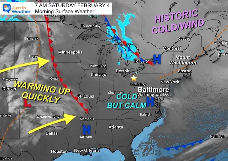
Weather February 4 – Morning
The accident occurred around 9 PM on February 3. This map best shows the overnight and early morning weather set up. I marked East Palestine, OH with a star on the map.
This was during that brief arctic blast. High Pressure was in control and the air was calmer after the wind storm the day before. This was the event that brought mount Washington, NH that record low wind chill (wind peak 127 mph and wind chill -108ºF).
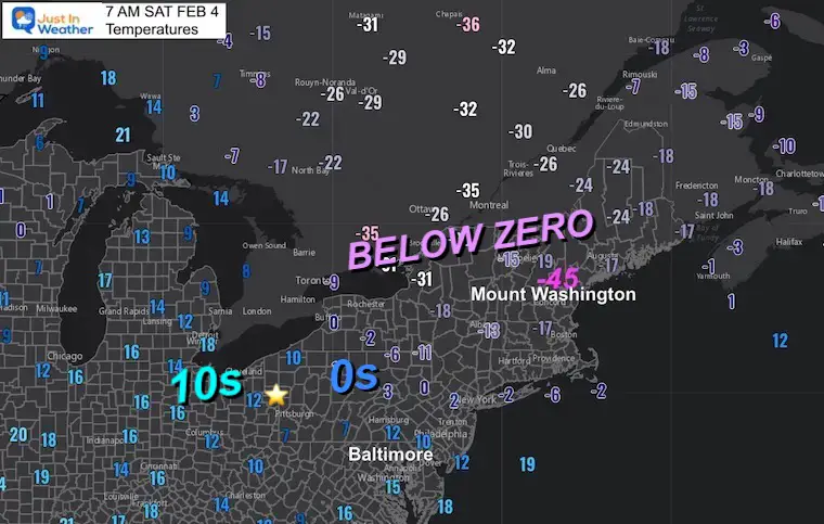
Regional temperatures ranged from the teens in eastern Ohio to well below zero across the Northeast.
Based on this, there would have been very little immediate transportation of airborne chemicals. The winds were light, but a push from the south developed over the next day.
Morning Temperatures
Given the extreme cold and light wind, it can be suggested that anything airborne might have remained lower to the ground (inversion aloft) and not spread immediately.
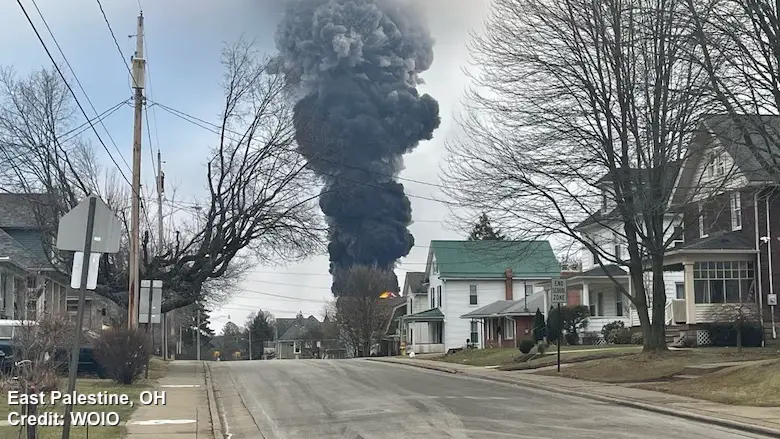
Controlled Burn on February 6
At 4:35 PM, the spilled chemicals were ignited along the railroad tracks. This is according to Scott Deutsche of Norfolk Southern.
Video Of The Controlled Burn
This has nearly 3 million views
Locals are calling it their Chernobyl.
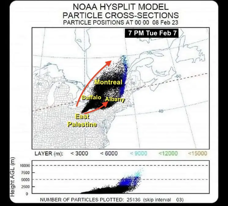
Inversion
All I can suggest here is that the weather conditions contributed to keeping the chemical cloud lower and traveling farther. An inversion is when there is a layer in the atmosphere as you travel UP, where the temperature warms instead of normal cooling. This can prevent rising air from rising higher, essentially trapping it.
Here we see that inversion keeping the cloud from the controlled burn of spilled chemicals staying in the lower atmosphere and traveling hundreds of miles to the North and Northeast (due to winds from the South).
Dispersion Of Chemicals
Using NOAA’s HYSPLIT Model
From the NOAA Air Resources Lab: The Hybrid Single-Particle Lagrangian Integrated Trajectory model. This is used to track a single air particle to show how far and in what direction it travels. We have used this to plot the origin of arctic air, and even retroactively plot the suspected path of the Chinese Spy Balloon.
Here we can see the cloud spread with the wind to the North and Northeast. A high enough concentration was determined to have reached across northern Pennsylvania, Buffalo and Albany in New York, and beyond to Montreal in Canada.
Local Water Concern This Week!
Yesterday I shared a video showing a rock being thrown into a local stream in East Palestine that resulted in colorful bubbles and an oil like sheen rising to the surface.
This is both alarming AND has raised some questions about what is in the water that may have either been there beforehand, or additional chemicals beyond the known Vinyl Chloride.
We know from multiple accounts that the fish kill is fresh given the state of the bodies recorded in the water.
Videos
I have multiple recordings here to answer any suspicion.
2 Miles From The Accident
Simply poking a stick in the water to move the bottom silt stirs up chemicals that do not look natural.
Local New Reporting
It is not just the silt, it is tossing a stone to stir up the water. This story has been slow to gain national coverage, but local news outlets are reporting this as well.
From US Senator J.D. Vance
Please know this is not politically driven regardless of your preference. Both Democrats AND Republicans locally are voicing their concerns.
From Nick Sorter
This is the full view of what I shared yesterday. This has been viewed over 6 million times.
Is This In The Water System?
I CANNOT Confirm this is connected. I am showing you this because it has been shared by many. I continue to encourage questioning.
Location: Williamsburg, OH is near Cincinnati. This is about 270 miles from East Palestine… But is downstream in the Ohio River.
Watershed
This is the same information I provided in my prior report:
This is a region that defines where water drains through stream and rivers.
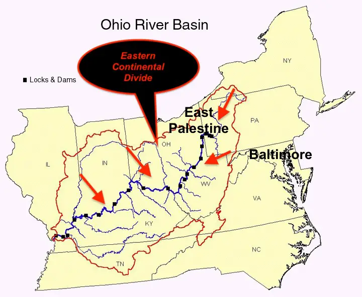
Ohio River Basin
The water from East Palestine does flow into the Ohio River. This also includes the 3 Rivers from Pittsburgh and Garrett County in western Maryland. All of this connects with the Mississippi River and drains into the Gulf of Mexico.
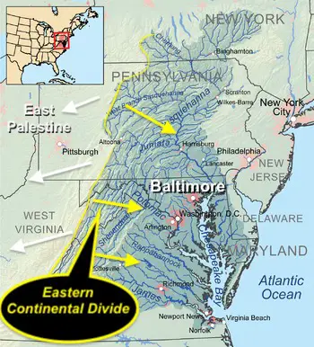
Chesapeake Bay Watershed
This includes my forecast area in the Mid-Atlantic. Here water drains into the Chesapeake Bay and eventually the Atlantic Ocean. We get water from as far north as Cooperstown, NY, on the Chenango and Susquehanna Rivers.
The western flank is the Continental Divide. If you have driven to western Maryland, this is around the Garrett County border. The Shenandoah and Potomac Rivers flow our way.
Included is most of central Pennsylvania, Maryland, and Virginia.
All points east flow to the Chesapeake Bay. All points west flow to the Ohio River Valley. East Palestine is NOT in our Watershed.
If you want more info, see my prior report. I do NOT want to add to the hype, but I do want accurate information and help for the locals. I will do my best to sort out the valid reports and share what I can along the way. Personally I am concerned that the impacts may be more comprehensive and widespread. So this does concern a very large population outside of the initial zone.
IMPORTANT NOTE:
I wrote a report with all the legitimate info and some controversial videos about the toxic train derailment in East Palestine, OH. I also explained how this relates to the Chesapeake Bay and Ohio Watersheds. Please click here for the image below if you missed that report.
Subscribe for eMail Alerts
STEM Assemblies/In School Fields Trips Are Back
Click to see more and ‘Book’ a visit to your school


Please share your thoughts, best weather pics/videos, or just keep in touch via social media


