February 16, 2023
Thursday Morning
Clouds are already moving in ahead of the next rain event, which should arrive around noon. Temperatures are warm, but not as warm as yesterday… and we will likely halt the rise as the rain arrives.
Yesterday in Baltimore, BWI reported 71ºF at 4:31 PM. This fell short of the record 77ºF in 1949.
Tomorrow will start off like spring, the morning storm line may contain thunder, then windy and turning much colder in the afternoon.
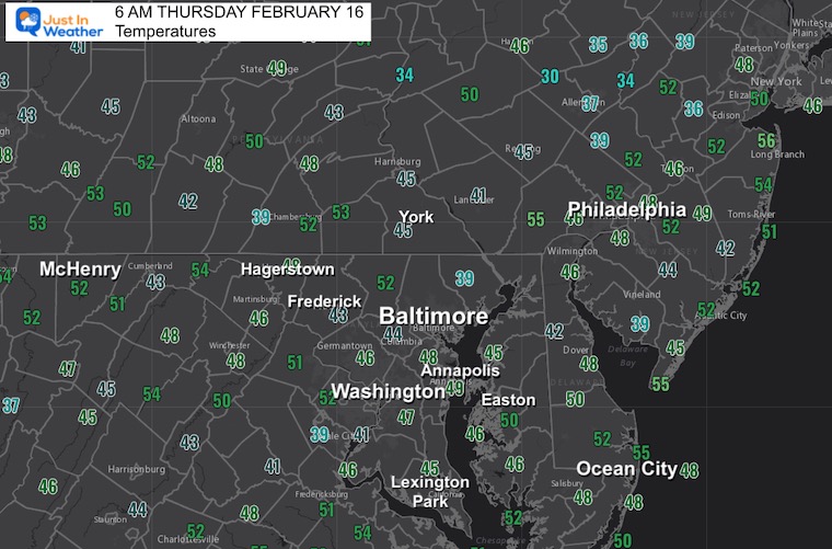
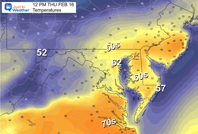
Morning Temperatures
Following the very warm day yesterday, temps have remained very mild.
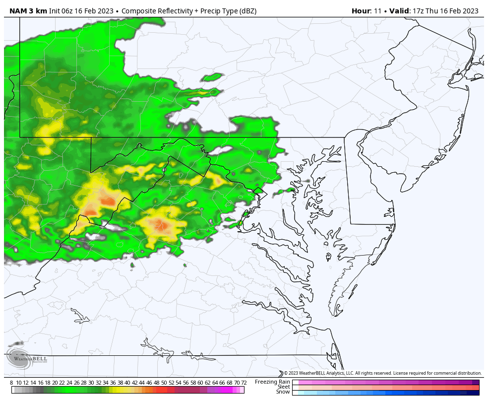
Morning Surface Weather
Clouds moving in this morning. Rain will arrive around noon.

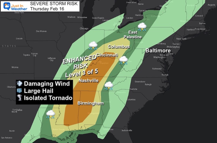
Severe Storm Risk
This storm will bring a severe weather outbreak into the Ohio River Valley. Threat for damaging wind, hail, and some tornadoes includes Nashville, TN, Cincinnati, and Columbus in Ohio.
IMPORTANT NOTE:
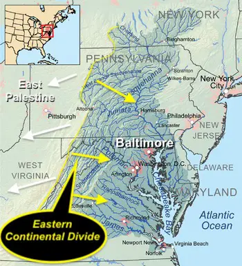
I wrote a report with all the legitimate info and some controversial videos about the toxic train derailment in East Palestine, OH. I also explained how this relates to the Chesapeake Bay and Ohio Watersheds. Please click here for the images if you missed that report.

Live Radar Widget
Tracking the rain that will arrive this afternoon.
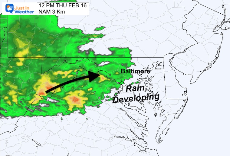
Noon Snapshots
Radar Forecast
Rain should be developing across our region around lunchtime.
Temperatures
The high today will be around the time the rain arrives. So not as warm as yesterday.
Radar Simulation Animation
Noon to 11 PM
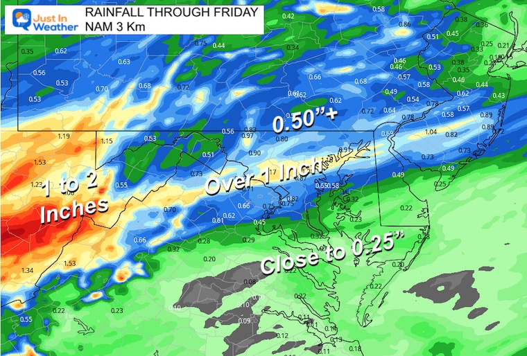
Rain Forecast
A stripe of 1-inch of rainfall is expected to extend from the mountains into metro Baltimore.
Subscribe for eMail Alerts
CLIMATE DATA
TODAY February 16
Normal Low in Baltimore: 27ºF
Record 5ºF in 2015
SNOW: 21.8” in 2003
Normal High in Baltimore: 47ºF
Record 75ºF 1954
Friday Weather
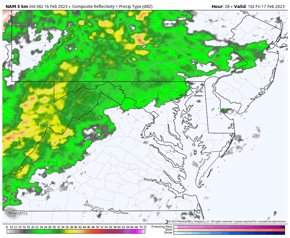
NAM 3 Km Model: 5 AM to 3 PM
Rain and Stormy morning with the cold front.
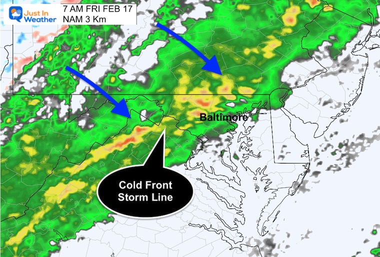
7 AM Snapshots
Radar Forecast:
Heavy rain will return with the cold front. This may contain some rumbles of thunder.
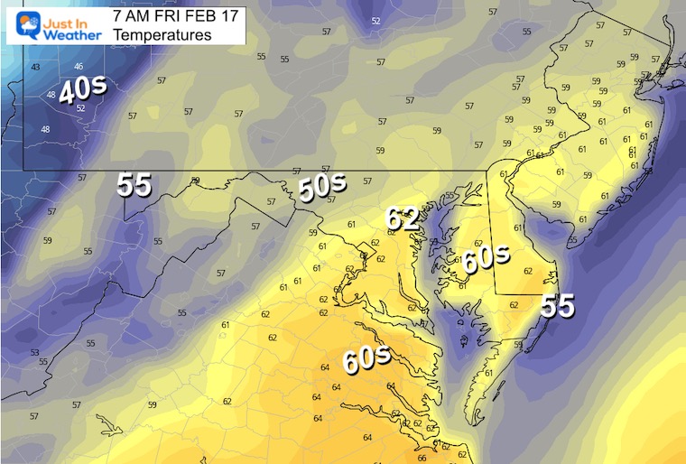
Temperatures:
The warmest time of the day may be around sunrise in metro areas… before the cold front arrives.
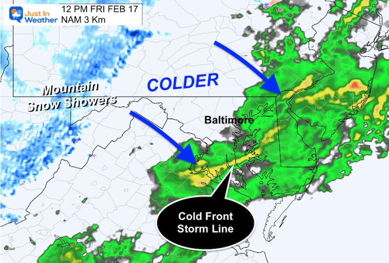
12 PM Snapshots
Radar Forecast
The cold front will be passing south and east of the Bay Bridge. The signal of colder air will break out snow showers in the mountains.
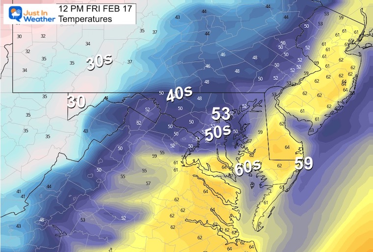
Temperatures
Much colder air will be rushing in through the afternoon and evening.
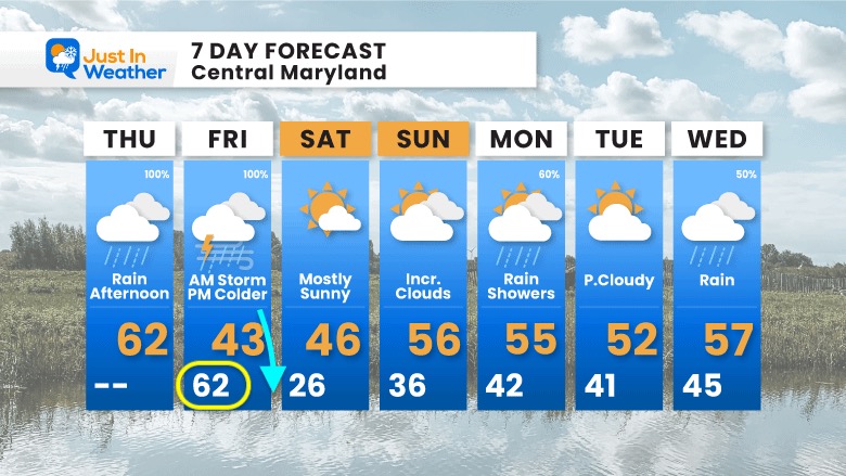
7 Day Forecast
The weird day will be Friday: Warmer at sunrise than in the afternoon.
Saturday will be chilly, then back to mild non-winter weather next week. Rain showers on Presidents Day!
Also See:
Winter History: Low Snow And Late Starts
See my research based on Baltimore data since 1883.

Subscribe for eMail Alerts
STEM Assemblies/In School Fields Trips Are Back
Click to see more and ‘Book’ a visit to your school

My Winter Outlook: Not A Typical La Niña!
I see many factors to support colder influence with multiple systems. Early and later in winter. Check it out.
https://justinweather.com/2022/11/22/winter-outlook-2023-for-snow-not-typical-la-nina-plus-polar-vortex-disruption/
Also See The Winter Outlook Series:
https://justinweather.com/2022/11/20/atmospheric-memory-suggests-active-winter-storm-pattern-outlook/
Winter Outlook 2023 La Niña Triple Dip Expectations
Farmer’s Almanac Comparison
September Starts Meteorological Autumn: Weather Climate Stats For Maryland at Baltimore
Triple Dip La Niña Winter
https://justinweather.com/2022/09/09/winter-outlook-2023-la-nina-triple-dip-expectations/
CONNECTION TO WINTER?
If you want a snowy winter, this is what you might want to look for in the rest of the tropical season.
Rainbow Ice Cave In Mt. Rainier A Very Rare Find: Photos And Video
Wooly Bear Caterpillars
https://justinweather.com/2022/10/25/winter-weather-outlook-from-the-wooly-bear-caterpillar/
Persimmon Seeds
Winter Weather Outlook: Persimmon Seeds And Snow Folklore
Click to see Top 20 and MORE
https://justinweather.com/2022/10/28/winter-weather-folklore-top-20-and-more-outlook-signals-from-nature-for-cold-and-snow/
Normals And Records: Maryland and Baltimore Climate History

Please share your thoughts, best weather pics/videos, or just keep in touch via social media


