February 15 Warming Up Today Then Rain Next Two Days
February 15 2023
Wednesday Morning
Early morning showers are shown on the live radar widget below. These will be brief and a signal of the leading edge of much warmer air. We will crank through the mid 60s to near 70ºF this afternoon, depending on how much sunshine you see. As warm as it may get, it is likely to not reach record levels.
A larger storm to the west will produce snow far west and severe storms in the Nation’s Heartland. We will get heavy rain from that system starting Thursday afternoon.
Headlines
- Today: Early showers, then WARMER
- Temps 65ºF to 70ºF but NOT a record!
- Rain Thursday and Friday
- Colder Start To The Weekend
Live Radar Widget
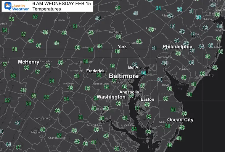
Morning Temperatures
Already mild and getting ready to warm up quite a bit more.
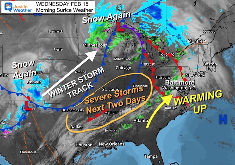
Morning Surface Weather
After the morning showers depart, we will get into a surge of warm air.
This is part of a larger storm system where the core and colder air continues to track between Denver and the western Great Lakes. THAT is where the snow continues to fall.
In the Deep South entering the Ohio Valley, there will be a severe storm outbreak today and more so tomorrow.
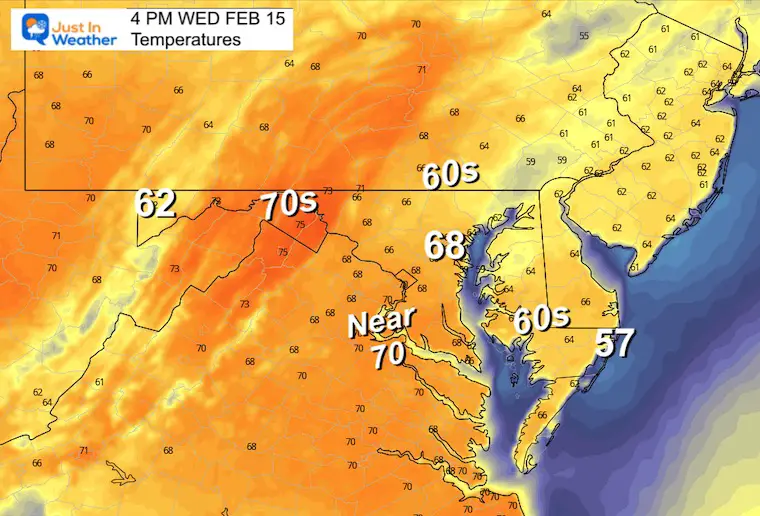
Afternoon Temperatures
Reminder: The RECORD HIGH for Baltimore was 77ºF in 1949
Often the weather observation is warmer than forecast. That is why I am plotting 70ºF in my 7-day below.
Most areas can expect 65ºF to 70ºF depending on how much sun you see. It will be warmer farther west.
Subscribe for eMail Alerts
Weather posts straight to your inbox
Sign up and be the first to know!
CLIMATE DATA
TODAY February 15
Normal Low in Baltimore: 27ºF
Record 6ºF in 2015
SNOW: 11.5” in 1958
Normal High in Baltimore: 46ºF
Record 77ºF 1949
Thursday Weather
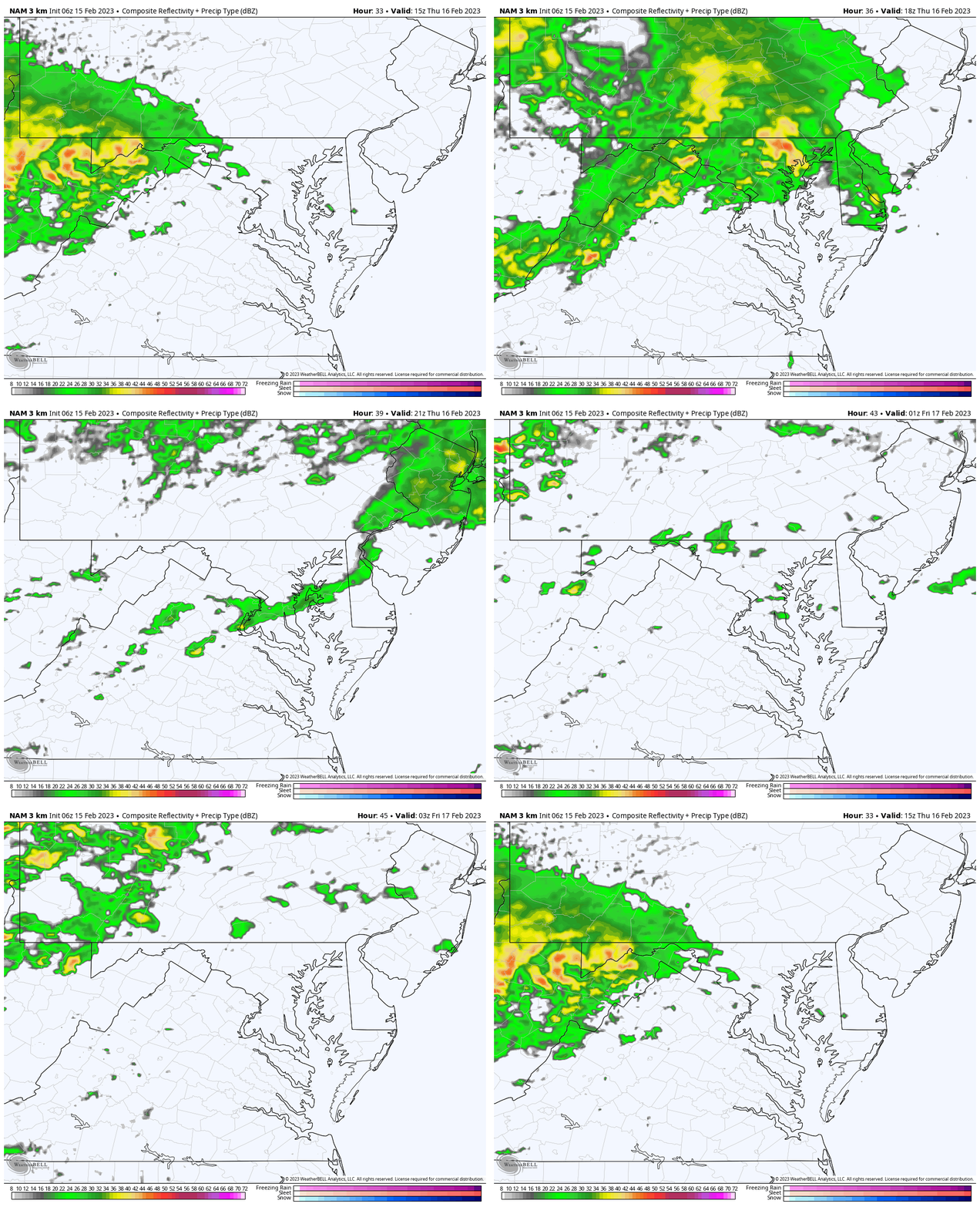
NAM 3 Km Model: 10 AM to 10 PM
Steady rain will arrive late morning and will be heavy at times through the afternoon.
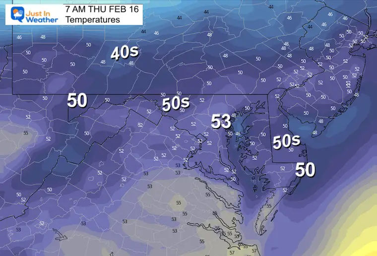
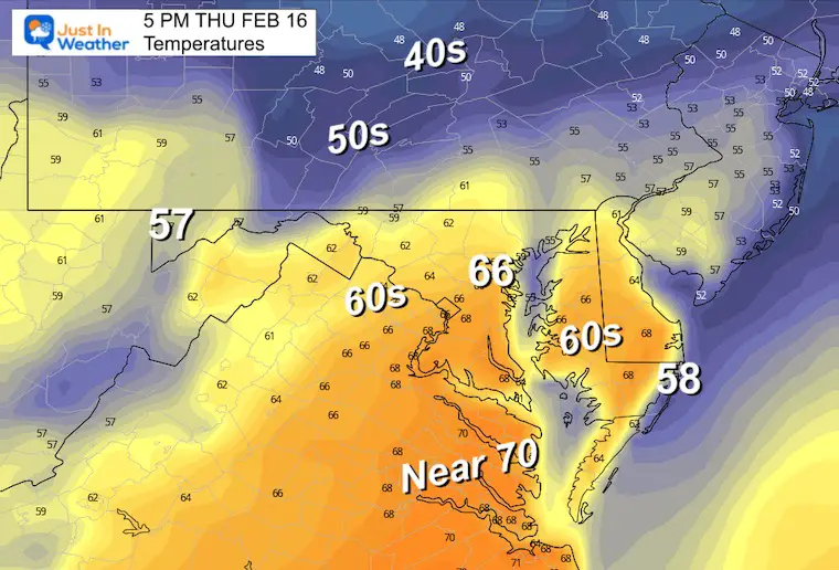
Temperatures
Morning
Still feeling like spring. These numbers are warmer than a typical afternoon high and more like Mid March.
Afternoon
Still warm, but tampered by the rainfall.
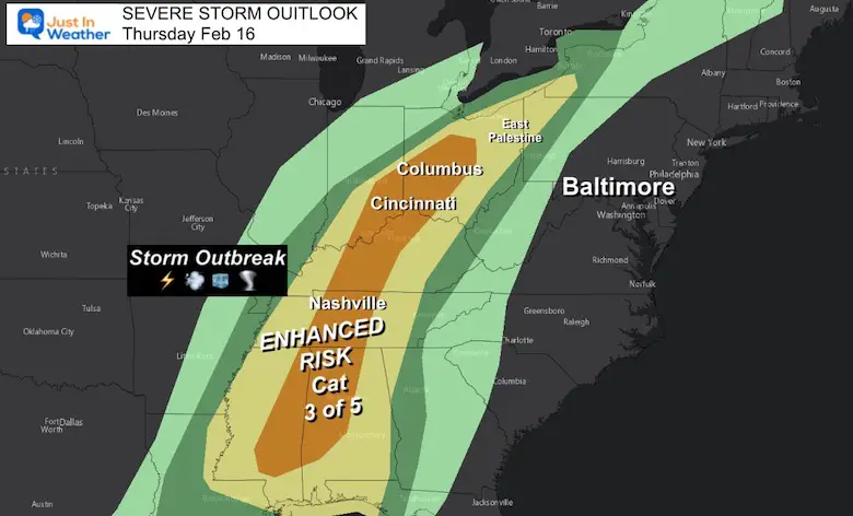
Severe Storm Risk Thursday
This storm will bring a severe weather outbreak into the Ohio River Valley. Threat for damaging wind, hail, and some tornadoes includes Nashville, Cincinnati, and Columbus in Ohio.
IMPORTANT NOTE:
I’ve added in East Palestine, OH for reference. I have been monitoring that toxic spill and ‘controlled’ burn. I want more concrete info before I write a report. For now, know that water is WEST of the continental divide and does NOT drain into the Chesapeake Bay Watershed. The wind flow could carry the impact northeast, airborne particles continue to be a concern within a 5 to 10 mile area with sick people and dead animals. The larger concern is what has already been deposited into the ground water.
A Town Hall meeting is planned for tonight with the local residents and I expect this will begin to be covered by more news outlets.
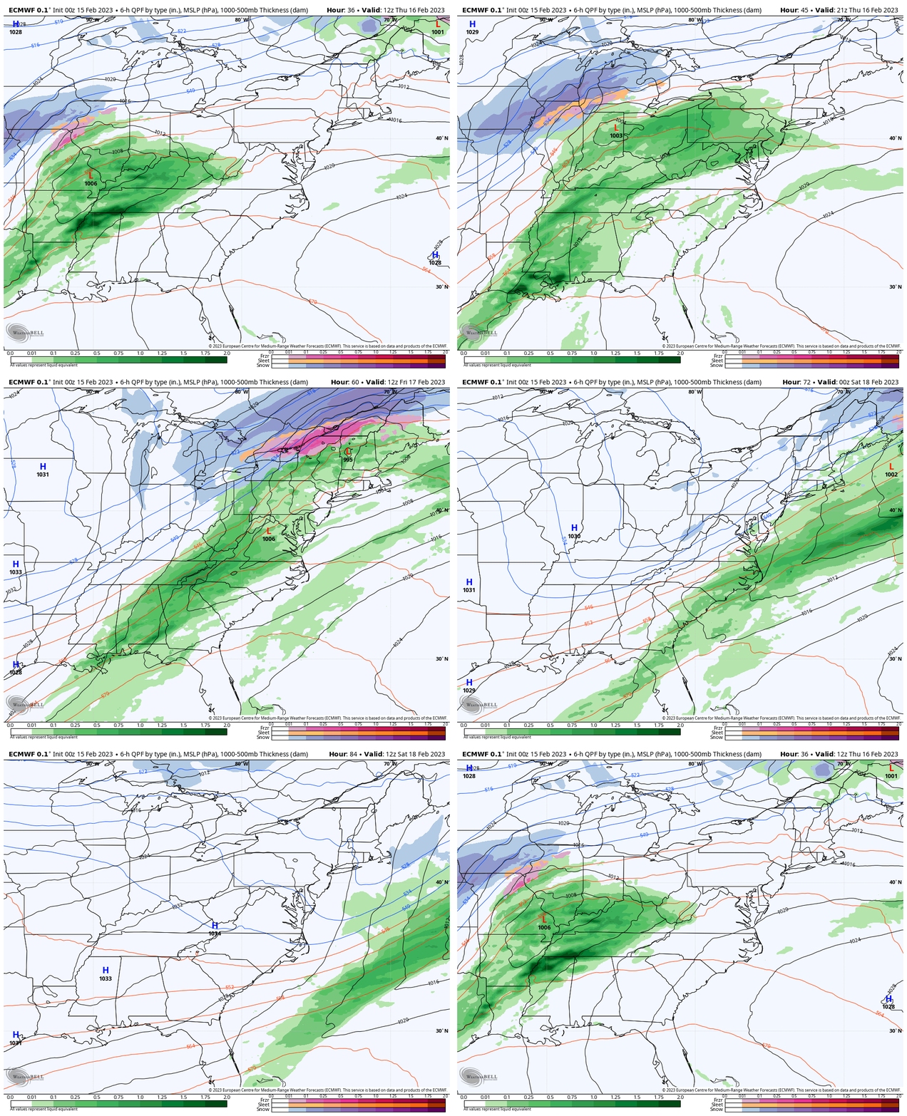
Wider View: Thursday Through Saturday
The wind flow aloft shows the warm East and colder West! When we get some chill, it does not last long. Temps will be falling all Friday, then bottom out on Saturday, only to bounce back with more mild air Sunday.
This is the theme we have had this winter. There is plenty of cold air, it’s just having trouble getting here. Once it does, it does not stay long.
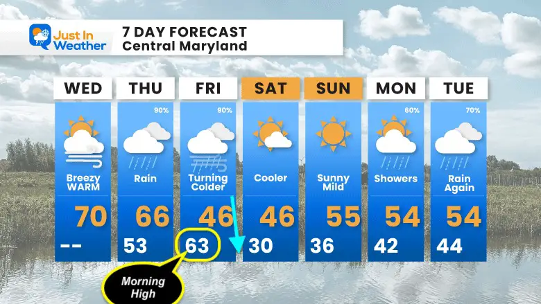
7 Day Forecast
Still no winter.. yet. After today’s warm day, rain returns Thursday. Friday will bring a cold front early. The high temperature will be close to midnight, then falling into the 40s by the afternoon.
One chilly day on Saturday, then back to mild temps again. There is a signal for some wintry weather next week but I am not touching that yet until we get closer due to phantom events on models all winter.
Also See:
Winter History: Low Snow And Late Starts
See my research based on Baltimore data since 1883.
Subscribe for eMail Alerts
Weather posts straight to your inbox
Sign up and be the first to know!
STEM Assemblies/In School Fields Trips Are Back
Click to see more and ‘Book’ a visit to your school
My Winter Outlook: Not A Typical La Niña!
I see many factors to support colder influence with multiple systems. Early and later in winter. Check it out.
Also See The Winter Outlook Series:
Farmer’s Almanac Comparison
September Starts Meteorological Autumn: Weather Climate Stats For Maryland at Baltimore
Triple Dip La Niña Winter
https://justinweather.com/2022/09/09/winter-outlook-2023-la-nina-triple-dip-expectations/
CONNECTION TO WINTER?
If you want a snowy winter, this is what you might want to look for in the rest of the tropical season.
Rainbow Ice Cave In Mt. Rainier A Very Rare Find: Photos And Video
Wooly Bear Caterpillars
https://justinweather.com/2022/10/25/winter-weather-outlook-from-the-wooly-bear-caterpillar/
Persimmon Seeds
Click to see Top 20 and MORE
Normals And Records: Maryland and Baltimore Climate History
Please share your thoughts, best weather pics/videos, or just keep in touch via social media
-
-
Facebook: Justin Berk, Meteorologist
-
Twitter: @JustinWeather
-
Instagram: justinweather
-


