


May 1 Weather Gradual Cooling Trend Will Bring Rain Into The Weekend
Wednesday, May 1 Morning Report One of the marks of May Day is an ancient European holiday celebrating the start of summer. It feels like we have had our taste…
January 26, 2023
Friday Afternoon Update
I do NOT make weather promises more than a week away. What I do see are signals for a change in the atmosphere, and this far out, I’m simply comparing how different computer models are handling them. They are guidance but not great with fine details.
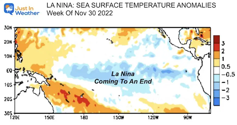
As we begin to focus on the weather pattern next week, I want to start with my inner conflict. I have high confidence that temperatures will be trending colder across the Eastern US. However, there is no guarantee that it will bring snow. There is hope for winter lovers as the energy will be trying to catch up to the colder air. There is also Global Support for the rest of winter, which I will touch on below (La Niña coming to an end).
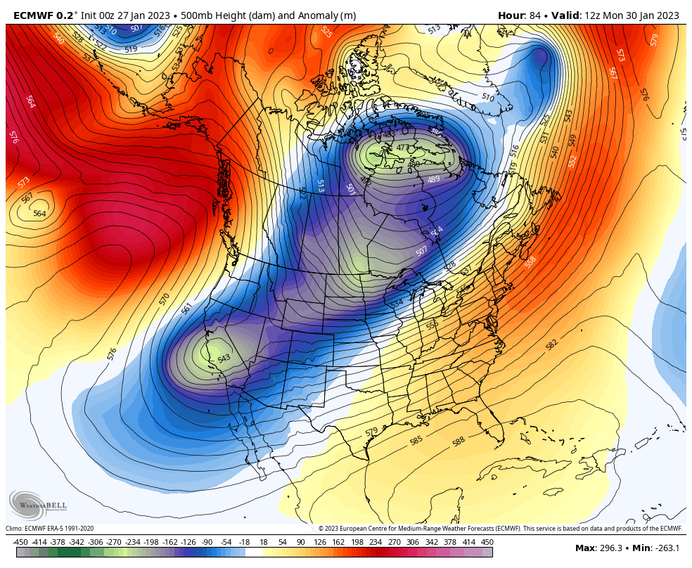
In my outlook update last night, I showed a very aggressive European Model trying to bring a strong coastal winter storm next weekend. I wrote on that map that I intended it to change, and it has. I expect we will see more changes ahead, and comparing to other models, it can become quite dizzying. My goal is to share enough to keep you in the loop and focus on the prize. That prize is snow for fellow boarders, kids (at heart), and anyone frustrated by this snow drought.
A few have asked what Dr. Judah Cohen, our arctic expert, has said about this. He seems to be excited too. I agree: The NEXT FEW WEEKS are our BEST CHANCE for snow around I-95.
Wise words “expect the worst, hope for the best.” The Canadian ensembles show strongest signal yet for #snowfall in the Mid-Atlantic States for the first week of February. Signal in the GFS ensembles much weaker. The next few weeks is the best chance to end the I95 #snow drought pic.twitter.com/TWdlL8SmYK
— Judah Cohen (@judah47) January 26, 2023
I will show two models, then compare them below.
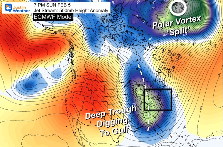
The Euro does show the Polar Vortex becoming dislodged, allowing a pool of colder air to spill into the eastern US. The circulation itself will remain in Canada. However, an elongated deep trough will dip all the way to the Gulf of Mexico next weekend. This helps to feed the notion of colder air and a costal storm.
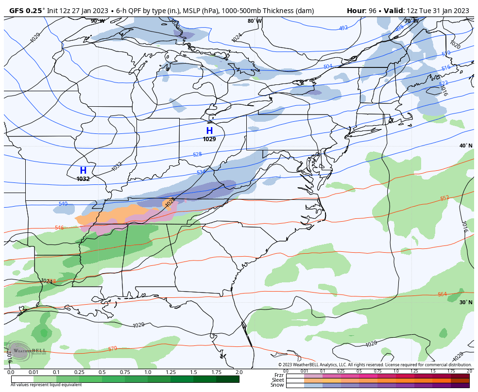
Our American product starts the same, but splits the Polar Vortex. This delays the trough impact in the US, thus allowing that next storm to form later and track to our west. That would be a familiar sight and once again a rain maker for the East Coast.
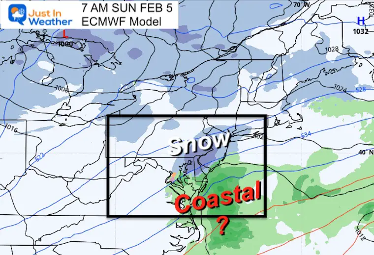
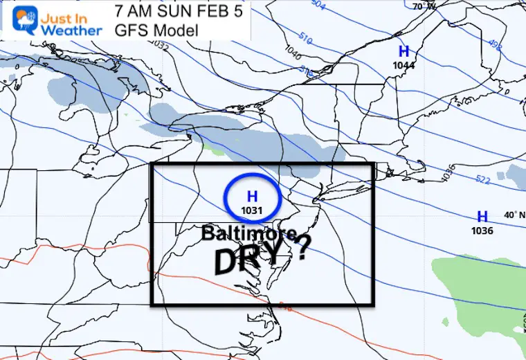
Snapshot: Sunday Feb 5
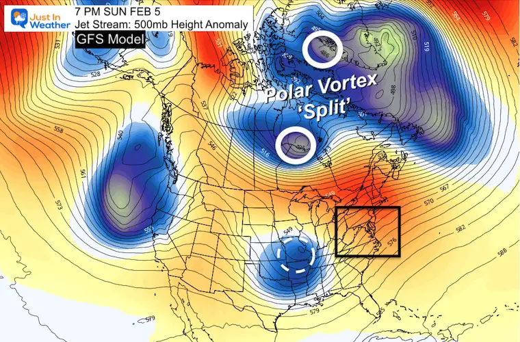
I chose this February 5th spot because it is the end of next weekend, and when the Euro has a coastal storm forming.
It is amazing that just 9 days away there can be such a dramatic variation of results. At this point it is prudent to lean on the European Model as it has been more reliable and holds credibility.
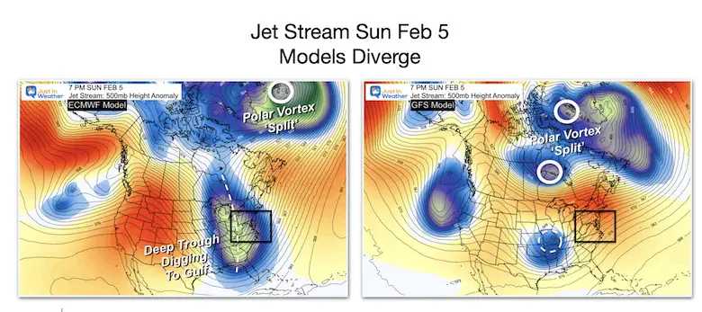
See the animations below…
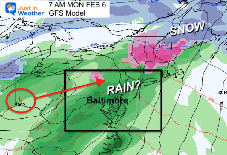
This is the same time frame from the above image, just the surface reflection. Here we see the drama play out. Euro has a coastal storm forming, albeit much smaller than it showed in prior plots. The GFS is vacant of active weather. This actually brings the Low in a day later and much farther west… See below.
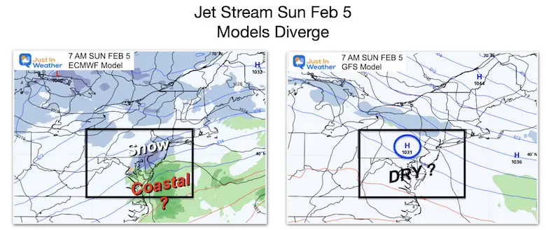
Look closely and see the snow actually get pushed farther south, barely clipping southern Maryland. I don’t buy this solution. The end shows the coastal storm, compact but enhancing for New England NEXT Sunday.
Here is the location of the compact snow ‘suggestion’ for the Mid Atlantic.
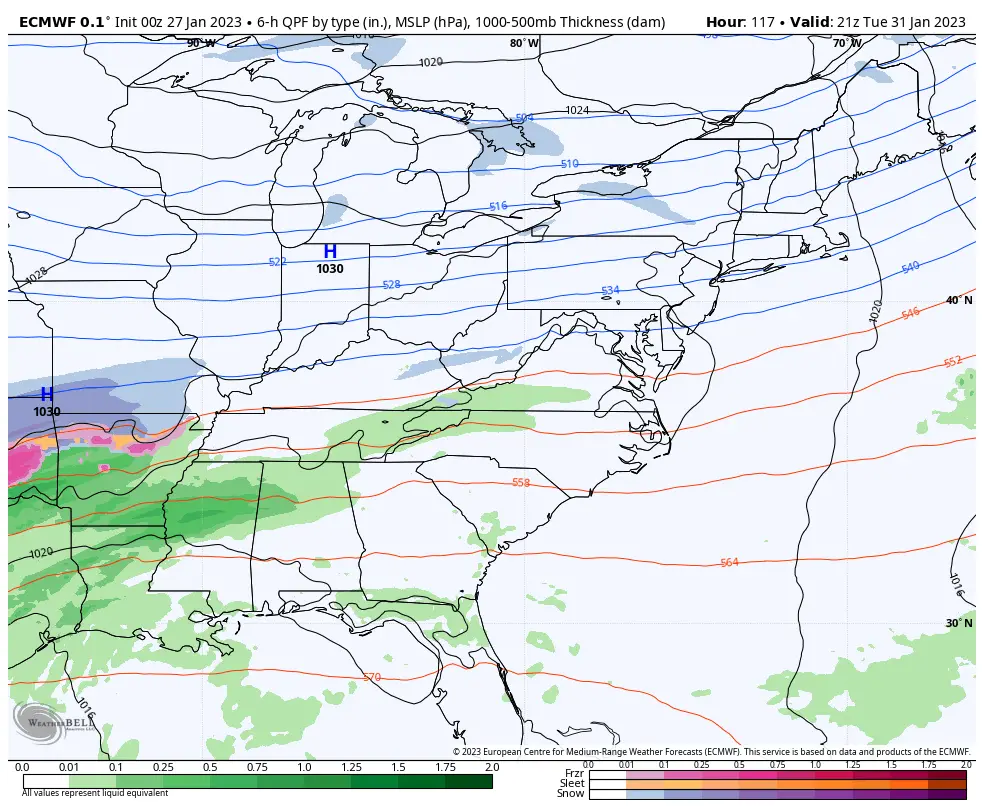
This also surpasses the snow South of Baltimore. Then that larger storm is delayed until Monday, with a warmer inland track. The result (if true) would be rain.
This is the time when the Euro showed the Mid Atlantic storm forming.
This is the inland Low track, keeping us on the warmer and rainy side.
The next 10 days are still uncertain, but definitely favorable from an atmospheric standpoint. My buddy Tony Pann has been happy for this as well. I am not as bold as him to block people for denying, but I feel his frustration at being overwhelmed by many doubters.
Baltimore could be “in the game” next week. -AO/ +PNA could beat down the SE Ridge for a while, as a series of storms travel along the Southern Edge of the cold air. 👇 Bottom line: Looks good for snow next week. I’ll block anyone who says: “I’ll believe it when I see it!” 😁❄️🚂 pic.twitter.com/lnEseuA5f4
— Tony Pann (@TonyPannWBAL) January 26, 2023
Dr. Cohen is still expecting a SECOND STRETCH of the Polar Vortex after this one… So if one of these do not work out, there may be more behind it.
Every world class athlete knows that to perform at the highest levels you need to stretch & so it seems with the #PolarVortex (PV). One PV stretch ongoing, delivering #cold & #snow to North America & models increasingly suggest yet another stretched PV for second week of February pic.twitter.com/g4fu614Lyq
— Judah Cohen (@judah47) January 27, 2023
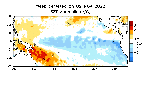
This is the Sea Surface Temperature Anomaly
Nov 2 2022 to Jan 18 2023
The blue is the region of below normal tropical water temperatures in the Pacific along the equator. That area is shrinking, suggesting the ending of this La Niña.
The end of winter is more favorable for our weather pattern as the Tropical Pacific should end the Triple Dip La Niña and go neutral.
This is what I reported back in early December: Click here for that report
Winter History: Low Snow And Late Starts
See my research based on Baltimore data since 1883.


Click to see more and ‘Book’ a visit to your school

I see many factors to support colder influence with multiple systems. Early and later in winter. Check it out.
Winter Outlook 2023 For Snow Not Typical La Niña Plus Polar Vortex Disruption
Atmospheric Memory Suggests Active Winter Storm Pattern Outlook
Winter Outlook 2023 From NOAA Very Different Than Farmers Almanacs
Winter Outlook 2023 Early Look At Snow From Two Farmers Almanacs
If you want a snowy winter, this is what you might want to look for in the rest of the tropical season.
Record August For No Named Tropical Storms: Closer Look At Snow Following
Winter Weather Folklore Top 20 And More Outlook Signals From Nature For Cold And Snow
