January 20 2023
Friday Night Update
My recent reports about the chance for snow simply falling and not sticking has brought out the full spectrum across the internet. In my line of work and personal affinity for winter, I am well aware of the many that are excited to just watch snow fall. I know this is a contrast to many like my wife who would be happy if they never see a flake again.
Then there are a select few that are either angry this winter has been a dud to date in the Mid Atlantic region, or just want to state this is the same old thing.
If you scan back for the past two weeks of my reports, I pushed my ‘mid month’ change to January 22 to 26, and this seems to be right on schedule.
This is the time frame I marked for a pattern change and that is exactly what we will get. The issue I believe is that even with a shift in storm tracks, that it does not promise a snow storm. Maybe that got lost in translation, but is not completely lost in our weather potential.
Brief Weather Recap (based on Baltimore)
December was colder than average!
December 24 = 20ºF High Tied The Coldest Afternoon High
January 3 = 69ºF set a NEW Record High
Snow To Date = Trace on Dec 18 and 23
Latest Measurable Snow
We are about to enter the Top 6 Dates This Weekend. Please notice the YEARS. This is rare, but has happened before scattered across last century.
- Feb 21 in 1973 (50 years ago)
- Feb 6 in 1914 (109 years ago)
- Jan 25 in 1992 ( 31 years ago)
- Jan 25 in 1901 ( 122 years ago)
- Jan 22 in 1966 (57 years ago)
- Jan 21 in 1907 (116 years ago)
Can we stop this comparison in the next week? MAYBE!!!!
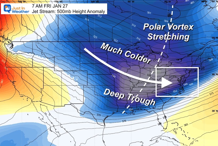
Jet Stream: 7 PM SUN JAN 22 to 7 AM FRI JAN 27
Snapshot: 7 AM FRI JAN 27
A deep trough will dig a stretched polar vortex with cold air to the Gulf Coast. We will have reinforced cold air through next weekend. (I will go out a little farther in time at the bottom of this post).
TWO WEATHER EVENTS: Sunday AND Wednesday
The storm track is changing and it is more favorable for winter weather. What is missing is the arctic air. I have made this point often: Falling snow most likely will not stick locally on Sunday.
If we get snow to fall as this begins, even with temps above freezing, there will be a frenzy of excitement. It will not be for all of our region, so if you live south of Baltimore or by the Chesapeake Bay and do not see it, there is still a large portion of areas in the colder inland suburbs that may.
EVENT 1: Sunday Morning to Monday Evening
ECMWF Model
Please see the snapshots below with my notes.
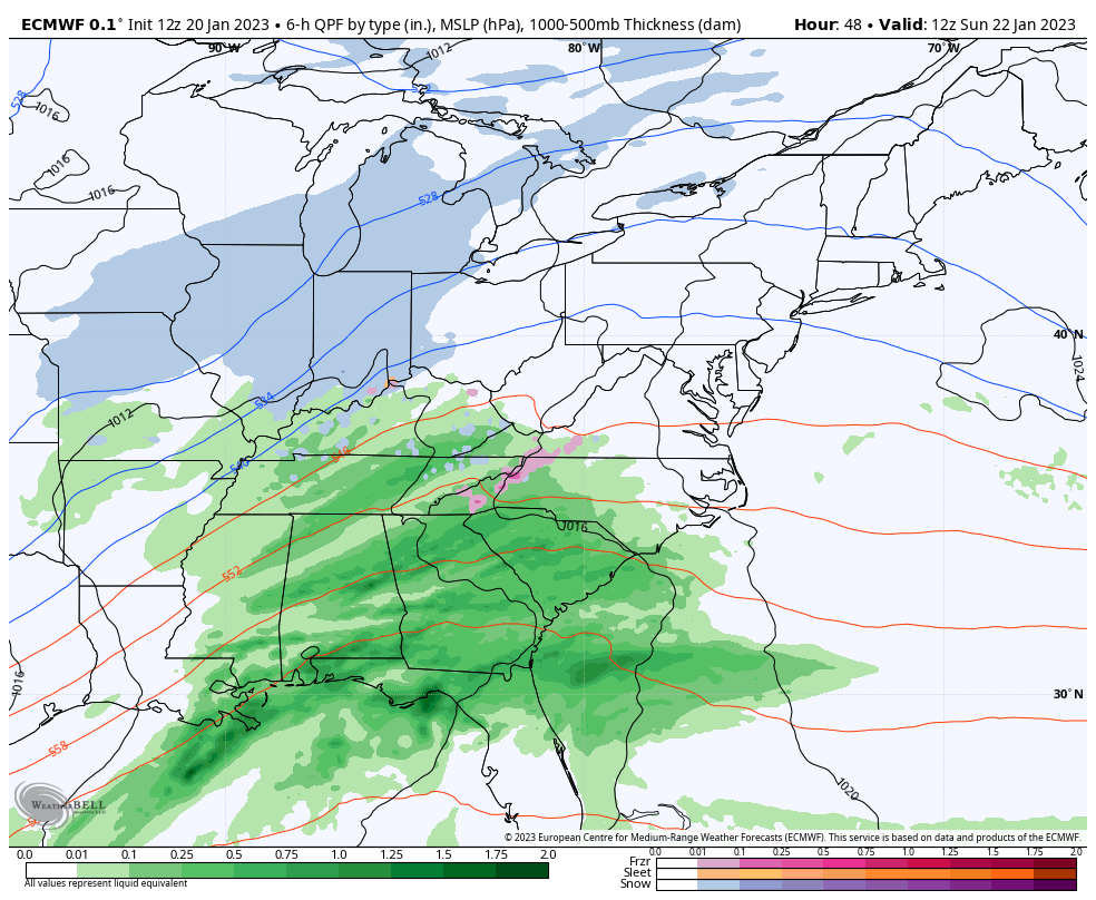
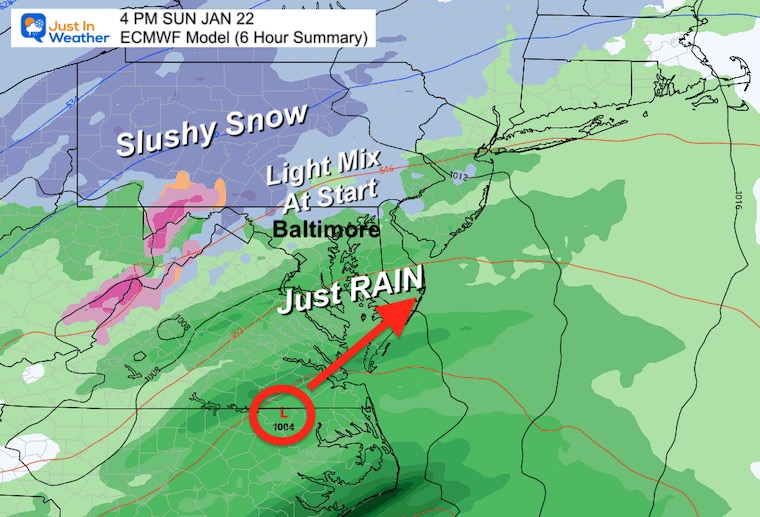
4 PM Sunday
This is a 6 hour summary of precipitation, but it looks like we could see the beginning near or just after noon. With the exception of flurries last week, this is the closest any snow has shown up since December 23.
The ECWMF Model still is showing some snow across northern Maryland within 10 miles of the PA line, and extending back to the mountains. The Giants playing the Eagles in Philadelphia will be Saturday night and missing this event.
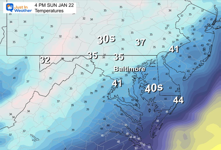
Temperatures
I have continued to show our region above freezing. Even if there is colder air aloft, we do not have support for any impact on the roads.
Other Models
The Canadian GEM actually expands the wintry (falling) precipitation across central Maryland to include metro Baltimore and northern Washington suburbs.
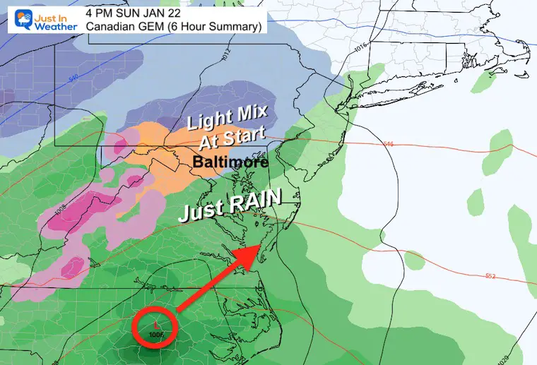
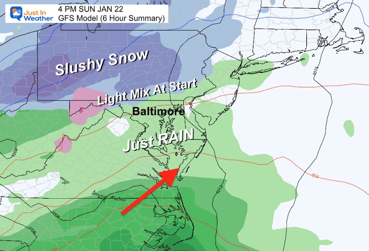
The GFS Model is the warmest (remember when it was the coldest with more snow a few times in December). This keeps the snow line north of the Pennsylvania border, with some possibly across northern Frederick County mountains.
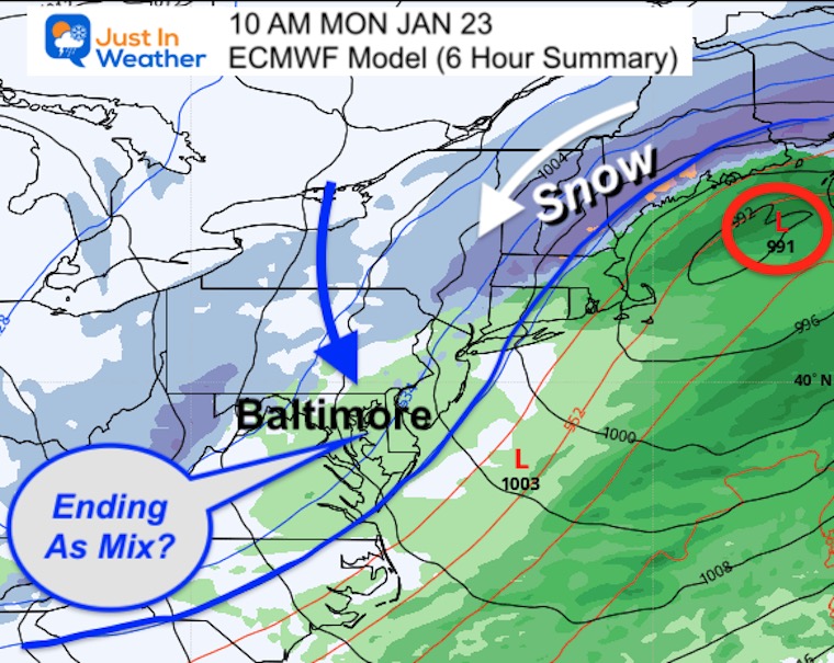
MONDAY MORNING
Back to the European Model, I see lingering moisture that will be light. The 540 line I highlighted is a parameter where the freezing line is in the atmosphere. This may allow the back end to be flurries or snow showers. Still – NO STICKAGE. Just Flakes Falling (possible).
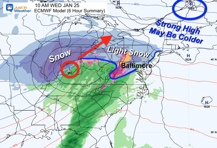
EVENT 2: Wednesday Morning to Thursday Evening
ECMWF Model
This is another wintry start to rain event, but not exactly the same. Please see the snapshots below with my notes.
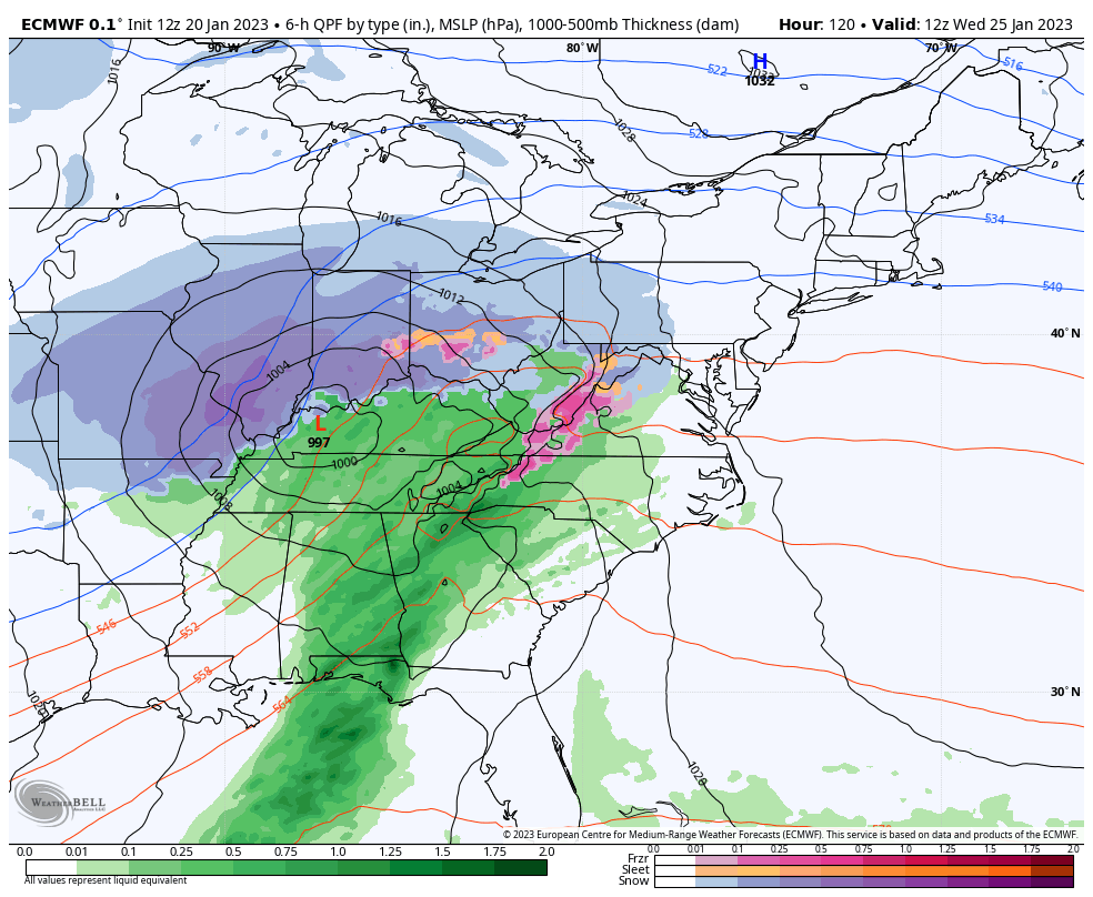
10 AM WEDNESDAY
This is interesting. As this storm does track west (again), there is more cold air to work with. High Pressure north of Maine will be a strong force for colder air, and we could end up with a longer period of snow at the start.
I must add the model error: Running too slow. If this verifies earlier, then we could be looking at a start of wintry weather before sunrise and would need to keep a close eye on any impact. Yes, this may turn to rain, but the first few hours are a change in our weather for sure.
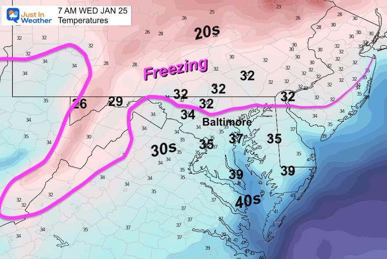
Temperatures AT 7 AM
I purposely went back to sunrise to account for an earlier arrival. Now we see more freezing temperatures a little closer. This is still marginal at best, but worth tracking for trends.
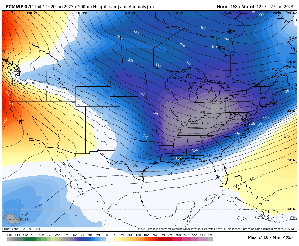
Looking Ahead: Jet Stream
Snapshot: 7 AM FRI JAN 27
This is the same time frame I showed above. At first glance, this deep trough may look like Winter is finally setting up shop. However, at this time the modeling has it being abruptly pushed out.
Animation: Friday Morning to Monday Morning
This shows a rapid snap back of the ridge across the Eastern US. I am a little suspicious of this, but if this verifies, it would send a serious blow to our winter chances for another one to two weeks deep into February.
I am the one who coined the phrase atmospheric memory a very long time ago and use it often. However, patterns that set up will eventually break. Will this next week do that? The opportunities have been materializing. We just need to tap into more cold air. It is there, as I wrote recently with the all time record cold in Siberia. Can we get some of that cold here before the end of winter?
I have Faith in the Flakes
Faith in the Flakes Gear

What is Faith in the Flakes?
It began with my son in 2009
December 5th Snow In Baltimore And The Start Of Faith In The Flakes FITF
SNOWSTIX – Available Now

STEM Assemblies/In School Fields Trips Are Back
Click to see more and ‘Book’ a visit to your school

My Winter Outlook: Not A Typical La Niña!
I see many factors to support colder influence with multiple systems. Early and later in winter. Check it out.
Winter Outlook 2023 For Snow Not Typical La Niña Plus Polar Vortex Disruption
Also See The Winter Outlook Series:
Atmospheric Memory Suggests Active Winter Storm Pattern Outlook
Winter Outlook 2023 From NOAA Very Different Than Farmers Almanacs
Farmer’s Almanac Comparison
Winter Outlook 2023 Early Look At Snow From Two Farmers Almanacs
Triple Dip La Niña Winter
Winter Outlook 2023 La Niña Triple Dip Expectations
CONNECTION TO WINTER?
If you want a snowy winter, this is what you might want to look for in the rest of the tropical season. (You might be seeing a lot of commercial snow removal people out this Winter).
Record August For No Named Tropical Storms: Closer Look At Snow Following
Wooly Bear Caterpillars
Winter Weather Outlook From The Wooly Bear Caterpillar
Persimmon Seeds
Winter Weather Outlook: Persimmon Seeds And Snow Folklore
Click to see Top 20 and MORE
Winter Weather Folklore Top 20 And More Outlook Signals From Nature For Cold And Snow
Normals And Records: Maryland and Baltimore Climate History

Please share your thoughts, best weather pics/videos, or just keep in touch via social media


