January 12 2023
Thursday Night Update
This is for snow lovers, dreamers, and me. Having Faith in the Flakes is a mantra that dates back to 2009 with my son and believing it will snow even when it is not in sight. Well, that guy is going snowboarding this weekend and turns 17 on Monday. We both have new boards and plans for the rest of the season together. So I write this as a meteorologist with no hiding that I personally want snow… for my son and all the kids I speak with across the region.
But please know there is legitimate science here. Plus, I will once again share direct notes from others in the industry to add depth to the conversation.
The day I am writing this has already brought a thundershower across the Chesapeake Bay north of Annapolis, with some more possible tonight. We are 12 days deep into a calendar year that started with the warmest week on record for Baltimore.
Latest First Snow?
Here is another set of records to compare our winter to…
Latest First Measurable Snowfall (Baltimore)
Please notice the years… We have had 4 winters in the top 5 that were 50 to OVER 100 years ago.
Top 5
- Feb 21 in 1973
- Feb 6 in 1914
- Jan 25 in 1992
- Jan 25 in 1901
- Jan 22 in 1966
Rank 6 to 10 (we may very well beat)
- Jan 21 in 1907
- Jan 19 in 2002
- Jan 19 in 1950
- Jan 17 in 2006
- Jan 16 in 2005
Sharing The Snow Drought, Or Not?
My friend Kevin Williams is a meteorologist in Rochester, NY. He notes the snow drought in his city, but that over all of North America is actually trending higher.
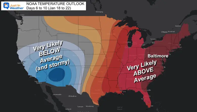
Warm Outlook From NOAA
The latest update is for Temperatures to remain ABOVE AVERAGE for the Eastern Half of the US for Day 6 to 10. This goes through January 22, and that date may be pivotal!
Before I show you you my maps, let’s hear from some others.
Dr. Judah Cohen, Arctic Climate Expert:
I love when other weather geeks show a sense of humor. Here he is showing his product increasing snow opportunities Jan 22 to Jan 26.
Tom Tasselmeyer, Chief Meterologist at WBAL
I worked with him from 1997 to 2003, and we are still friends. I have the utmost respect for his forecasting skill.
Here is he showing the global patterns turning favorable AFTER Jan 20.
I will show a closer look at the North Atlantic Oscillation in a moment. But first, let’s see some animations:
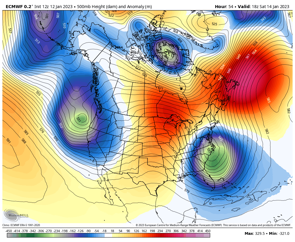
Jet Stream (ECMWF)
Sat Jan 14 to Sun Jan 22
After the chilly weekend, we will see another warm up and a few more weather systems tracking to our west. That will bring us rain.
The pattern appears to flip at the end of this period.
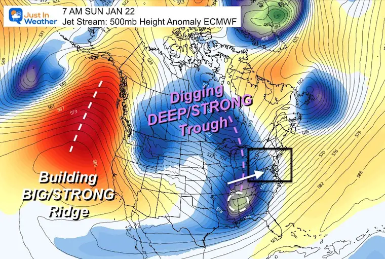
Jet Stream Sunday January 22
ECMWF Model – Height Anomalies
It may be 10 days away, but the storm hose should shut off for the western US as a large ridge of High Pressure is expected to build along the Pacific Coast.
Meanwhile, a deep trough will dig for the Eastern US.
This is a colder, and perhaps stormy pattern.
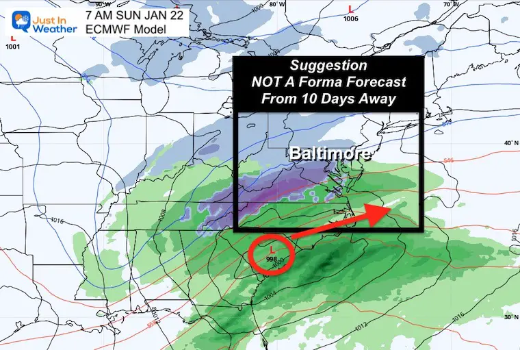
Just For Fun:
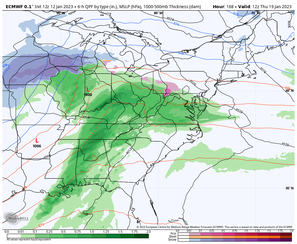
Let’s see how the ECMWF plots that stormy pattern.
This forecast simulation goes out 10 days, so I do NOT place much value in it. However, it will be a baseline to plot against.
ECMWF Model
Thu Jan 19 to Sun Jan 22
This starts with ANOTHER rain event, as Low Pressure tracks up the Ohio Valley. The following set up brings in a southern snow…
NEXT WEEEND?
Sunday January 22
This is purely for hope and joy, NOT A FORECAST. I know! How may times have we seen a storm plotted a week away that did not happen? I will not legitimize a storm forecast beyond 1 week, but if this does anything close to verifying, I will refer back to this post and give the Euro props!
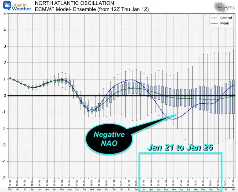
North Atlantic Oscillation
The North Atlantic Oscillation has a significant turn to NEGATIVE in the time frame from January 21 to 26. For now, this is our window of opportunity.
Back to Dr. Cohen:
He also seems bullish on the winter weather pattern for the end of the month. He is referring to Stratospheric Warming, which is what is needed for a Polar Vortex Disruption.
About That Polar Vortex
Meteorologist Mark Margavage showed how the GFS is catching up to the Euro with this Polar Vortex Disruption around January 22-23.
Can It Happen?
I know before the new year I made reference to the middle and back half of January for the turn. This looks like a fit, if possibly a week late for those who want to pin specifics down.
Going back to those late first snow dates, January 22 is the 5th latest date. If you have Faith in the Flakes, mark your calendars as we may edge that out or tie, if this latest European Model can hold some value.
FITF
Subscribe for eMail Alerts
Faith in the Flakes Gear

What is Faith in the Flakes?
It began with my son in 2009
December 5th Snow In Baltimore And The Start Of Faith In The Flakes FITF
SNOWSTIX – Available Now

STEM Assemblies/In School Fields Trips Are Back
Click to see more and ‘Book’ a visit to your school

My Winter Outlook: Not A Typical La Niña!
I see many factors to support colder influence with multiple systems. Early and later in winter. Check it out.
Winter Outlook 2023 For Snow Not Typical La Niña Plus Polar Vortex Disruption
Also See The Winter Outlook Series:
Atmospheric Memory Suggests Active Winter Storm Pattern Outlook
Winter Outlook 2023 From NOAA Very Different Than Farmers Almanacs
Farmer’s Almanac Comparison
Winter Outlook 2023 Early Look At Snow From Two Farmers Almanacs
Triple Dip La Niña Winter
Winter Outlook 2023 La Niña Triple Dip Expectations
CONNECTION TO WINTER?
If you want a snowy winter, this is what you might want to look for in the rest of the tropical season. (You might be seeing a lot of commercial snow removal people out this Winter).
Record August For No Named Tropical Storms: Closer Look At Snow Following
Wooly Bear Caterpillars
Winter Weather Outlook From The Wooly Bear Caterpillar
Persimmon Seeds
Winter Weather Outlook: Persimmon Seeds And Snow Folklore
Click to see Top 20 and MORE
Winter Weather Folklore Top 20 And More Outlook Signals From Nature For Cold And Snow
Normals And Records: Maryland and Baltimore Climate History

Please share your thoughts, best weather pics/videos, or just keep in touch via social media


