


May 11 Aurora Viewing Forecast Weather And More Photos
Saturday May 11, 2024 The display of Northern Lights last night was historic. As the name implies, this is more common in the Northern Latitudes. On rare occasions we can…
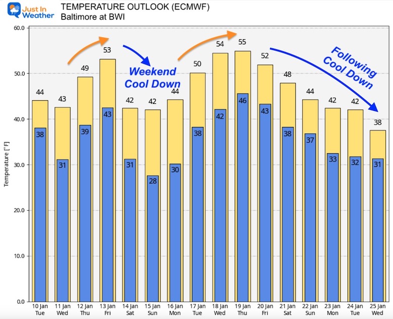
January 10, 2023
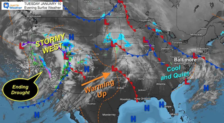
Tuesday Evening Update
So you are looking for snow? Me too! It’s why I got in to meteorology, plus I got myself a new snowboard and an anxious teenager ready to make some turns in the powder. Well, the local ski areas have been making snow, but it has been a struggle across the East with this record warm start to the year.
Yesterday I posted the NOAA warm outlook, but that does NOT mean winter is done. I am still in good company with other meteorologists seeing signs of the pattern changing by the end of this month.
This report is simply what I am looking at and what is a practical expectation for when the weather may turn.
First, let’s see the current set up where winter has been BOOMING, and the good that has come out of it.
While it is cool and quiet in the east, the western US remains stormy and more storms are lined up across the Pacific in that ‘atmospheric river’ you have heard about. This weather pattern is more like an El Niño than La Niña and has been a drought buster beyond any expectations!
The storms have been devastating and deadly. On the flip side, the long term effects have been equally astonishing!
Snowpack in California is 215% of normal! The Southern Sierra is 257%, which has been the hardest hit by the drought.
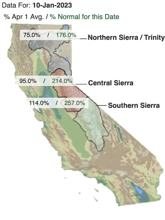
Drought improvement questions are coming up with the repeated #castorms and #atmosphericriver, bottomline is snowpack in Sierra Nevada is 2x average and higher than anytime in history (1982-83) and a location such as Mammoth has more snow (310 winter) than the prior 3 seasons pic.twitter.com/Vnx7GbLeEO
— NWS San Diego (@NWSSanDiego) January 10, 2023
California’s water resource situation has improved exponentially, seemingly overnight.
Water stored in the snowpack and reservoirs now exceeds the normal for the time of year and will continue to rise rapidly over the next 7-10 days. pic.twitter.com/8tiG1fZe2X
— Colin McCarthy (@US_Stormwatch) January 10, 2023
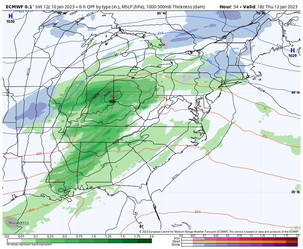
Storm Animation (ECMWF Model): Thu Jan 12 to Tue Jan 17
Like the last few, the next few storms will track to the Great Lakes, bringing our region the warm and rainy side… to be followed by colder air.
At this point, I can see how easy it is to believe this will not change, but it will!
I received an email from a reader in California today. She mentioned that their stormy pattern was supposed to end mid month, but get extended an extra week. There is an end in sight. The logic that followed was that she realized that often there is a flip between the coasts. While the West has been stormy, we have been warm. When their storms end, the energy is still in the atmosphere, but likely to shift to the East. I’ve seen it countless times… and am looking for signals to show it.
This upper level pattern is more reliable than the surface weather forecasts. This had shown our pattern turning sooner, but it has been delayed. For what it is worth, I have discussed that we often do see a delay from the first suggestion of a pattern change. This is the second signal and I am showing you this for a suggestion of ‘when’ we are looking for winter to try and come back.
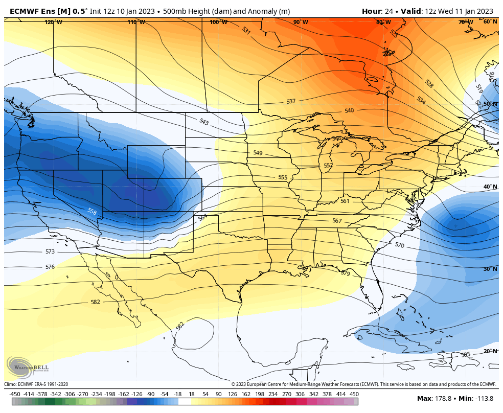
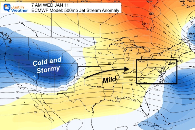
Nothing new to see here: Mild weather expanding east ahead of the next storm. The cold and stormy weather is under that trough in the Rockies.
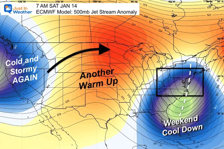
The deep trough over the Southeast US Coast is the next cool down following our rain storm. This does fit the pattern we have had before. There is a chance for upper level energy to bring on flurries, but not much more for this round.
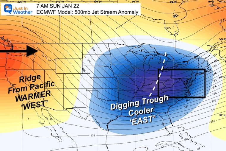
I know, this is almost 2 weeks away, but it is the long range signal of hope. This shows the storms cutting off for the west coast as a ridge develops there. That will allow a trough to dig in for the eastern US, bringing colder and stormy weather. The larger pattern does look more like one that would hold this for the end of the month.
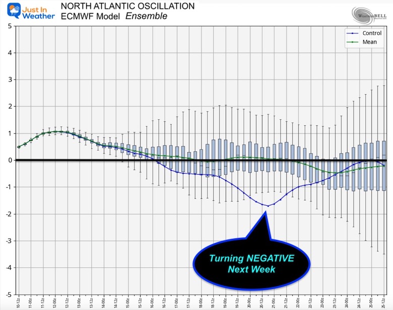
This is the signal of blocking near Greenland that helps to bring cold air to the eastern US. The European Model Ensemble is showing this turning Negative next week. The largest dip is around the 20th.
There does not appear to be an arctic outbreak, but we can see the impulses knocking down the warmth to average and trending colder.
This is not wishful thinking, it is logistically a practical expectation for the weather pattern to evolve and shift later this month.
The fact that we DO NOT see a snow event on the models over the next 1 to 2 weeks is actually a good thing! When we do see one that far off, it has not worked out. So NOT seeing one now may prove to bias the other way.
I truly hate to keep kicking the can down the road. This report was my intention to keep you in the loop with what I am watching and give a time window for reference.
At this point, my ‘last half of the month’ is looking like the last week to 10 days of the month.
Please keep in mind that 80% of our snow often falls after January 15, so there is plenty of time to catch up.
FITF

December 5th Snow In Baltimore And The Start Of Faith In The Flakes FITF

Click to see more and ‘Book’ a visit to your school

I see many factors to support colder influence with multiple systems. Early and later in winter. Check it out.
Winter Outlook 2023 For Snow Not Typical La Niña Plus Polar Vortex Disruption
Atmospheric Memory Suggests Active Winter Storm Pattern Outlook
Winter Outlook 2023 From NOAA Very Different Than Farmers Almanacs
Winter Outlook 2023 Early Look At Snow From Two Farmers Almanacs
If you want a snowy winter, this is what you might want to look for in the rest of the tropical season. (You might be seeing a lot of commercial snow removal people out this Winter).
Record August For No Named Tropical Storms: Closer Look At Snow Following
Winter Weather Folklore Top 20 And More Outlook Signals From Nature For Cold And Snow
