


May 11 Aurora Viewing Forecast Weather And More Photos
Saturday May 11, 2024 The display of Northern Lights last night was historic. As the name implies, this is more common in the Northern Latitudes. On rare occasions we can…
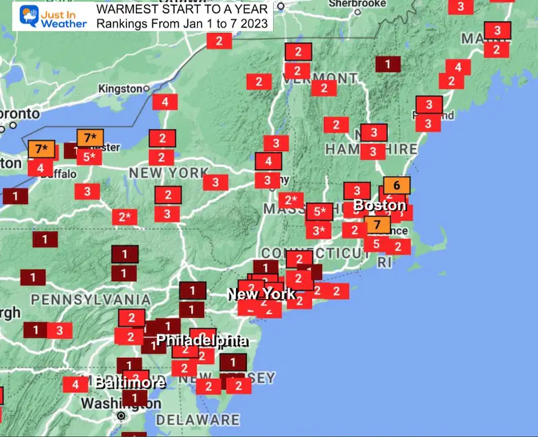
January 9 2023
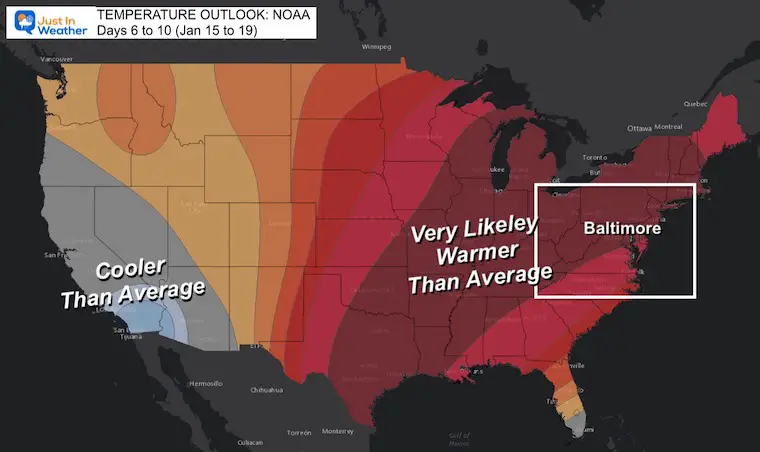
The reality is our winter here in the Eastern US seems non existent. After the arctic blast before Christmas, we have swung the pendulum to the warmest start to a year on record. Now to add salt to the wounds of snow lovers, the NOAA Temperature Outlook has a surge of warm air reemerging along and east of the Mississippi River Valley to the East Coast.
There is more to this story, in fact, the European Model is trying to produce some snow within this warm pattern ahead and there is historical support for that.
Note, Baltimore is at the bottom of this view, to highlight how we are sharing the weather pattern with New England.
Extremes do breed extremes: We had a record cold Christmas Eve afternoon before this warmth. It is very plausible that we may swing back the other way again this winter.
Please let me add a disclaimer. I am a meteorologist who loves snow and winter sports. I have been writing many reports about the Polar Vortex Disruption among other things with signals for a change. I still see a change, but it is going to take longer.
My winter outlook had a cold December, and we did end that month below average. Then a mild start to the year, but I never expected it to be this warm for this long. I have been advertising a cold pattern for the second half of the month, however if you are holding me to precision, it is NOT going to happen on January 16. Well, there is a chance for a cold blip in the middle of the warm pattern, but over the next 10 days, here is what NOAA has published.
I posted a Poll on Facebook earlier today. As of 7 PM, there were over 6,000 participants, with 55% sad about the lack of snow. I was surprised it was not higher, but we still have the edge of hopefuls with Faith in the Flakes.
This map shows the Odds of above or below average, not the actual temperature anomaly. Where I wrote “Very Likely Warmer Than Average”, the map is displaying an 80% chance of above average temps. There is no value attached to the thermometers in this product.
Benn Noll recently shared this map. All of that Blue highlights half of the winter affected US actually well above average.
Snowfall so far this winter has been below or well below normal (🟠) for many central & eastern states.
The north-central & west has been snowier than normal (🔵), with Minnesota being a particularly snowy standout ❄️ pic.twitter.com/NAShRq13xB
— Ben Noll (@BenNollWeather) January 7, 2023
Last night we had a weak weather system that did produce nearby snow stickage, but it didn’t last last. Here was snow cover as close as Hershey, PA.
The first snowfall of 2023 has left the #TheHotelHershey looking beautiful🌨️😍 pic.twitter.com/hopwiIRLQT
— Hershey PA (@HersheyPA) January 9, 2023
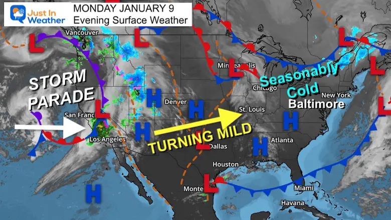
Where is winter? It is slamming the west coast. That Atmospheric River you may have heard about is a very active jet stream from the Pacific. The good news is that it is helping the fill up drought depleted reservoirs. Wait until you see below.
Meanwhile, this little cool down in the eastern US will modify ahead of that storm when it reaches us later this week.
According to Dr. Ryan Male, this is equivalent to 3.3 Trillion gallons of liquid equivalent precipitation for California!
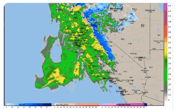
This high mountains near Lake Tahoe are expecting over 10 Feet of snow in 48 hours!
Then, another storm / event for Tuesday.
48-hours –> 📈10-feet of snow falls onto the Sierra ❄️⛰️
HRRR snowfall forecast: @weathermodels_ pic.twitter.com/maZhhVNATA
— Ryan Maue (@RyanMaue) January 9, 2023
This is where it gets interesting…
The European Model (the more reliable guidance as I have put the GFS aside for now) is showing the storm tracking to the Great Lakes. That means it will be on the warm and wet side… but only half the story.
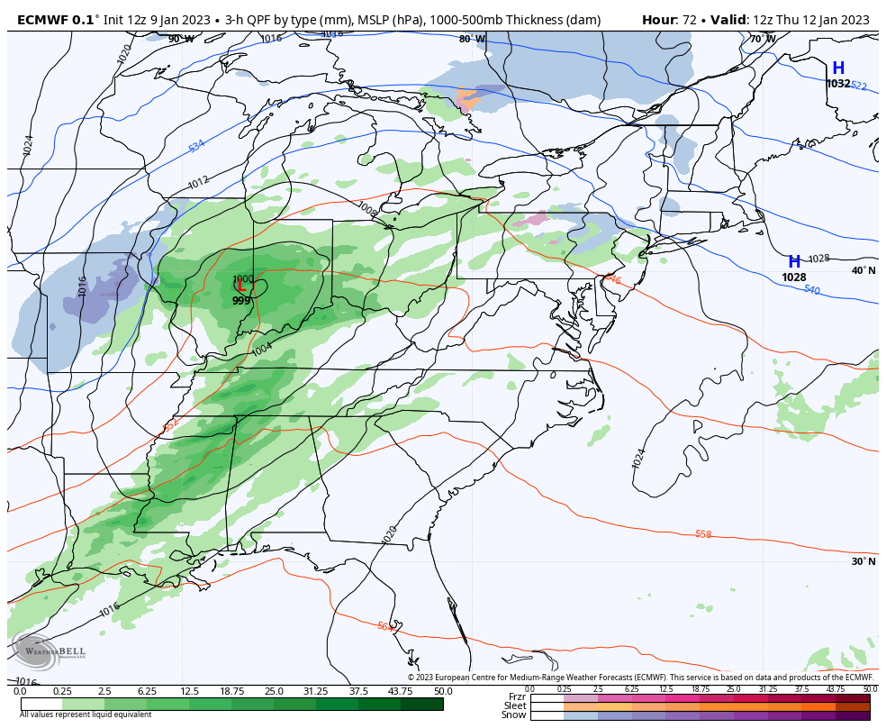
The back half of this storm lets the upper level Low Catch up with colder air and produce snow across the I-95 corridor. This is not an event I will put a lot of weight into after the last let down, but I will update you on it daily.
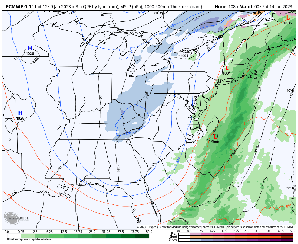
*I do expect this to change and only give this about 30% chance to verify, but it is trying to produce something.
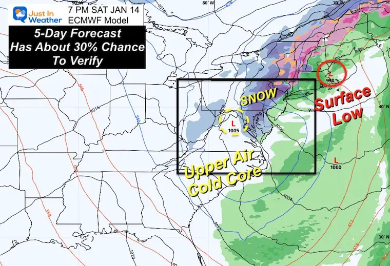
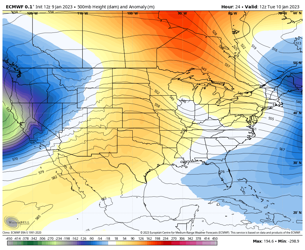
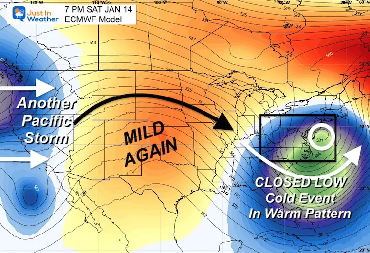
This is the upper air flow showing the warm-up ahead of the storm, then how a cold event (blue) will try to develop on the east coast within a warm pattern.
Again, there is about a 30% chance this verifies. Models have been trying to produce cold events, and end up with some moderated version of it. So once again we shall see.
The answer is yes and there are many examples I have given recently. For now, I want to repeat the one I citied in my winter outlook.
That winter started the year with another very warm week!
It should be noted, that season produced an ‘average’ snowfall most of which fell in those 10 days!
He has been exploring a Polar Vortex Disruption based on Upper Stratospheric Warming.
“If it walks like a duck, quacks like a duck, it’s a duck.” Models reversing & now showing a stretched #PolarVortex/wave reflection that brings colder weather to eastern North America. #MachineLearning model (has some timing issues) but has trended colder in East US for late Jan. pic.twitter.com/WMeVpJm6kv
— Judah Cohen (@judah47) January 8, 2023
There is support for snow in a warm pattern AND for that Polar Vortex Disruption I have talked about. I am not the only meteorologist following and anticipating it.
While I have mentioned the second half of January for the cooling, it does not look like it will be in the next 10 days, but we have 3 weeks left in the month for the move… At this stage it might be the end of that time frame… We are not done yet!
FITF

December 5th Snow In Baltimore And The Start Of Faith In The Flakes FITF

Click to see more and ‘Book’ a visit to your school

I see many factors to support colder influence with multiple systems. Early and later in winter. Check it out.
Winter Outlook 2023 For Snow Not Typical La Niña Plus Polar Vortex Disruption
Atmospheric Memory Suggests Active Winter Storm Pattern Outlook
Winter Outlook 2023 From NOAA Very Different Than Farmers Almanacs
Winter Outlook 2023 Early Look At Snow From Two Farmers Almanacs
If you want a snowy winter, this is what you might want to look for in the rest of the tropical season. (You might be seeing a lot of commercial snow removal people out this Winter).
Record August For No Named Tropical Storms: Closer Look At Snow Following
Winter Weather Folklore Top 20 And More Outlook Signals From Nature For Cold And Snow
