


May 1 Weather Gradual Cooling Trend Will Bring Rain Into The Weekend
Wednesday, May 1 Morning Report One of the marks of May Day is an ancient European holiday celebrating the start of summer. It feels like we have had our taste…
Thursday December 29 2022
If you are looking for winter weather and feeling bummed about the warm up, I have good news in this report. That is what I say as a snow lover and will explain our warm up with the Polar Vortex status, and show the signals for the disruption.
With all due respect, the recent record Christmas Weekend arctic blast AND Lake Effect Storm has resulted in dozens of deaths. That is the down side of any extreme weather event, so I will proceed with this report with the understanding of that dichotomy.
My son and I are among the snowboarding community and are anxious for powder. I guess we also have many kids and teachers on our side. But we understand the strain on heating bills and the homeless, so any lead time to the next surge can be helpful.
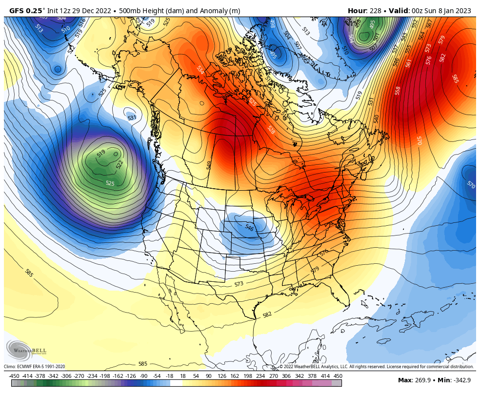
Here in the Mid Atlantic, centered around Baltimore, we are expecting a few days into the 60s during the first week of January 2023. This is nothing new AND not a bad time for a mild trend if you are a snow lover. About 75% of our average seasonal snow usually falls January 10 to February 28.
There are many years I can reflect on, but here are the two most dramatic in recent memory.
There are similar results for these dates across the Mid Atlantic region. Here are my two favorites, but there is a third explored below.
A warm New Year Week and New Millennium included 2 Record Highs
Many thought there would be no winter (again).
This was followed by a burst of 3 snowstorms in 10 days! Two of them were records!
*I remember that last event because it was Superbowl Sunday and I was moving to a new place with four bald tires on a U-Hall Truck in that slop! I had a great story the next day to report on WBAL.
First we need to look at the Christmas holiday. A big contrast to the holiday we just had. That year included the record high for Christmas Eve and December 27! We had temperatures flirting with 70ºF for nearly a week. This included a Christmas with 69ºF and thick fog, but not a record. We did get two record highs:
Once again, many people thought winter was never going to set in.
29.2 Inches at BWI fell in the 3rd week of January. Less than one month after the record warmth! It blew away the top snowstorms. This included the single day record.
This recent streamlined look at the Northern Hemisphere shows the dry streamline winds high aloft in the stratosphere. That tight circle around The North Pole keeps the very cold air locked up. The strong Zonal Flow off the Pacific will continue to provide a lot of moisture and energy pushing into North America.
I will post link to see the live view at the bottom of this report.
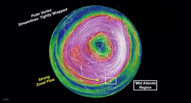
In short, it describes the upper air wind flow 10 to 30 miles up around the North Pole that forms every winter. The stronger these Westerly winds are, the more ‘stable’ and locked up the arctic air is inside. The Polar Jet Stream is lower between 5 and 9 miles aloft, and does influence our weather patterns. These don’t always interact, but when they do, the result can be strong to severe storms and or cold events.
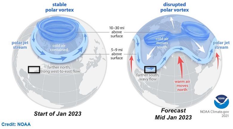
“When the Arctic polar vortex is especially strong and stable (left globe), it encourages the polar jet stream, down in the troposphere, to shift northward. The coldest polar air stays in the Arctic. When the vortex weakens, shifts, or splits (right globe), the polar jet stream often becomes extremely wavy, allowing warm air to flood into the Arctic and polar air to sink down into the mid-latitudes”
In short, a weaker Polar Vortex results in a wavy and stormy Polar Jet Stream, which increases our chances for cold and storms with snow.
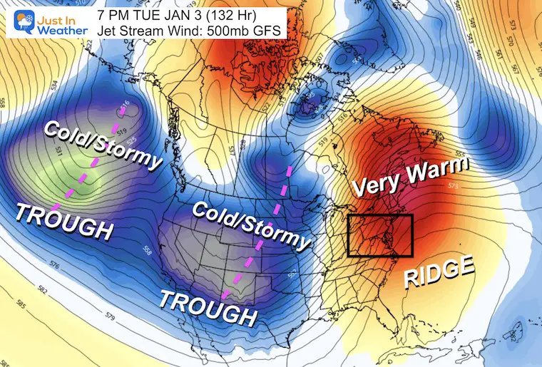
The active (cold) storms will come into the Western US with multiple ‘Troughs’ in the Jet Stream. The Eastern US will be dominated by a persistent Ridge and warming. We can see rippled and borderline cold within the pattern. That might be possible Jan 6-7. However, this is expected to peak early, and will try to change mid month.
The ridge in the Eastern US and Canada looks impressive, which could boost temperatures higher than models suggest now. Meanwhile a very active and stormy train is setting up in the Pacific for the West Coast and Rockies.
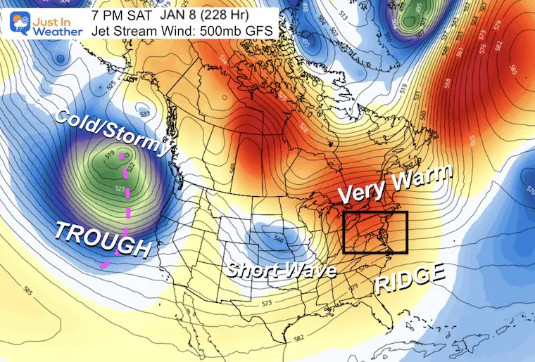
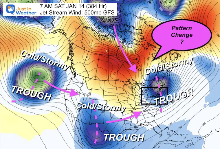
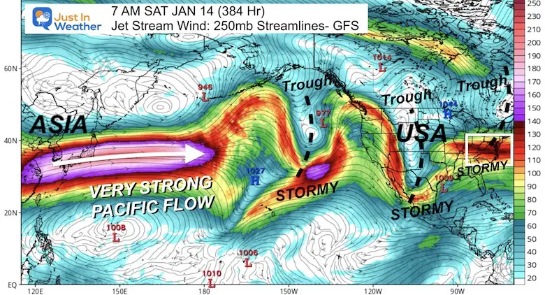
This looks a little more aggressive. While still with a ridge and warmth in the east, a short-wave in the central US could reach the east with a colder weather event. The Pacific will continue with a barrage of storms, and this one in the Northwest looks very dynamic!
I know – This is a very long range outlook. I do not agree with surface plots (with rain or snow), but global patterns like the jet stream are a little more reliable in this time frame. Let’s look at the transition for trends.
This looks like we have a winter-type event for the Northeastern US. I would NEVER suggest specifics this early, but I do need to add this caveat:
OFTEN we see cold signals a week or two ahead, but they can verify a few days later than first shown. I am keeping that in mind with my more detailed forecasts.
I am not alone in believing that mid January will make the turn.
In his words
Winter weather wise, we’re quiet in DC the next couple weeks. Models hint at stratospheric warming & polar vortex displacement (but not split) mid-JAN, but often it takes longer than models think for these shifts to impact the lower atmosphere. No action until after the 15th IMO. pic.twitter.com/Gl1MjyoAyN
— Mike Thomas (@MikeTFox5) December 29, 2022
IMO= In My Opinion, I agree with him. There are others in this group.
Winter weather wise, we’re quiet in DC the next couple weeks. Models hint at stratospheric warming & polar vortex displacement (but not split) mid-JAN, but often it takes longer than models think for these shifts to impact the lower atmosphere. No action until after the 15th IMO. pic.twitter.com/Gl1MjyoAyN
— Mike Thomas (@MikeTFox5) December 29, 2022
We can add this to my list of flips for the winters I showed above. That winter resulted with a season total of 39 inches of snow for BWI, nearly DOUBLE a normal winter.
If we do flip the switch back to cold mid month, the source region for storms will still be VERY ACTIVE across the Pacific.
This is centered on the Pacific Ocean with Asia on the left and USA on the right.
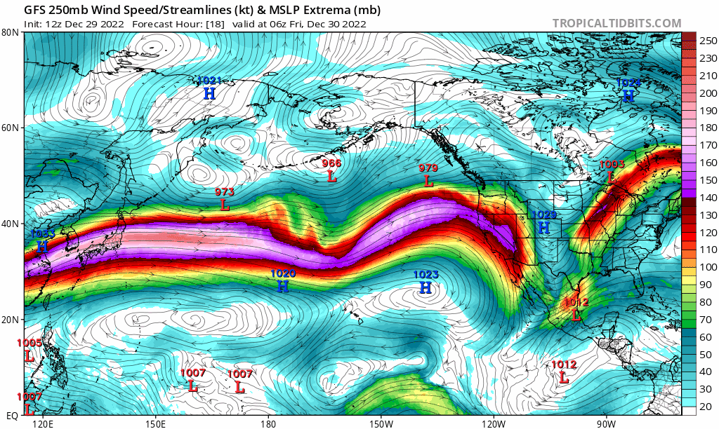
My Gosh, this looks more like an El Niño rather than a fading La Niña!
If you have Faith in the Flakes, so do I. My WINTER OUTLOOK For 2023 called for an early start to December, which we have seen with this recent arctic blast, followed by a moderate period, then cold and stormy end to January into February. This still looks on point.
The warm start to a calendar year is nothing new and has recent history of being followed by an abrupt flip of weather fortune during the later half of the month of January.
FITF (Faith in the Flakes)
Click here to see the live view from Earth Nullschool

December 5th Snow In Baltimore And The Start Of Faith In The Flakes FITF

Click to see more and ‘Book’ a visit to your school

I see many factors to support colder influence with multiple systems. Early and later in winter. Check it out.
Winter Outlook 2023 For Snow Not Typical La Niña Plus Polar Vortex Disruption
Atmospheric Memory Suggests Active Winter Storm Pattern Outlook
Winter Outlook 2023 From NOAA Very Different Than Farmers Almanacs
Winter Outlook 2023 Early Look At Snow From Two Farmers Almanacs
If you want a snowy winter, this is what you might want to look for in the rest of the tropical season. (You might be seeing a lot of commercial snow removal people out this Winter).
Record August For No Named Tropical Storms: Closer Look At Snow Following
Winter Weather Folklore Top 20 And More Outlook Signals From Nature For Cold And Snow
