


May 10 Chilly With More Rain Showers Today And Into Mothers Day Weekend
Friday May 10 Morning Report Today is the second day of the year, with sunrise before 6 AM in Baltimore, but like yesterday, we won’t see it. After a high…
Tuesday December 27
As we climb out of this historic holiday weather event, I wanted to take a look back at the month and look forward into January. There is something for everyone and I should point out this is often the case: extremes will breed extremes. What is on the way is a break from the deep freeze and those who don’t like winter are going to be happy.
We just had extreme cold, including our coldest Christmas Eve afternoon in 130 years! Buffalo just had an historic and deadly Lake Effect Snow event with over 4 feet of new snow. Now we turn the corner in a hurry for a warm start of the new year. But there are likely to be many more blips along the way through the rest of winter.
This chart below includes the daily temperatures at Baltimore’s BWI from December 1 through December 26. However, when we add in today (27th) it will be colder than average as well. The next few days will swing the other way.
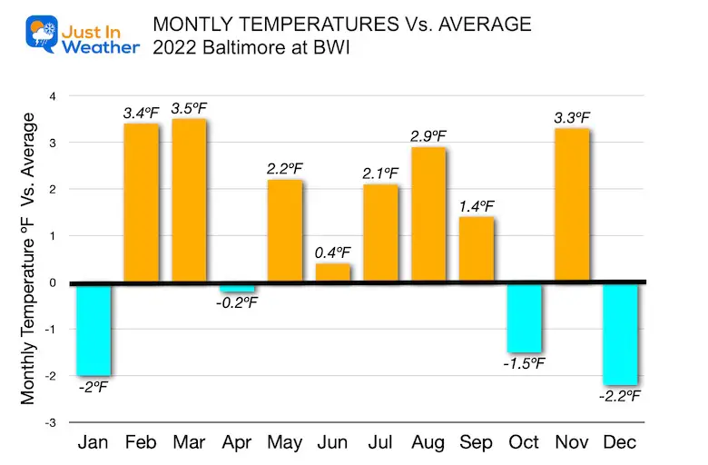
2.2ºF BELOW AVERAGE: Combine Max and Min Temps
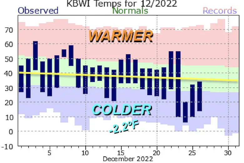
What makes this more impressive is that this only the 4th month this year below average, and the largest anomaly on the cold side.
If you recall My Winter Outlook, I had been suggesting we would have a push of early winter this month, followed by a mild trend. This did not promise snow, and we certainly just missed out.
Then I expected (and still do) a return to winter and snow for the second half of January and into February.
I say that, because the NOAA Winter Outlook had us with a warm winter. They also had us with a blowtorch December, until the post Thanksgiving Update began to trend colder.
December 1 Starts Meteorological Winter
🥶 ❄️ ⛄️
New NOAA Outlook supports COLDER TREND!
Similarities to 1995 and 2009 😏
👀 Look at Snowfall in Dec (Norm and Past 12 years)
ALSO: When we can expect this new pattern.https://t.co/MQrDiTnoKv— Justin Berk (@JustinWeather) December 1, 2022
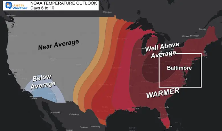
Eastern Half of the nation expected to flip from the Freeze to Much Warmer!
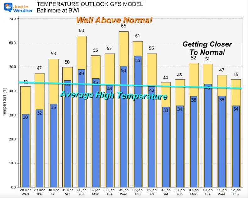
This temperature outlook represents the warming Well Above Average we will experience New Year’s Day and perhaps during next week as well.
This is only looking ahead Day 6 to 10.
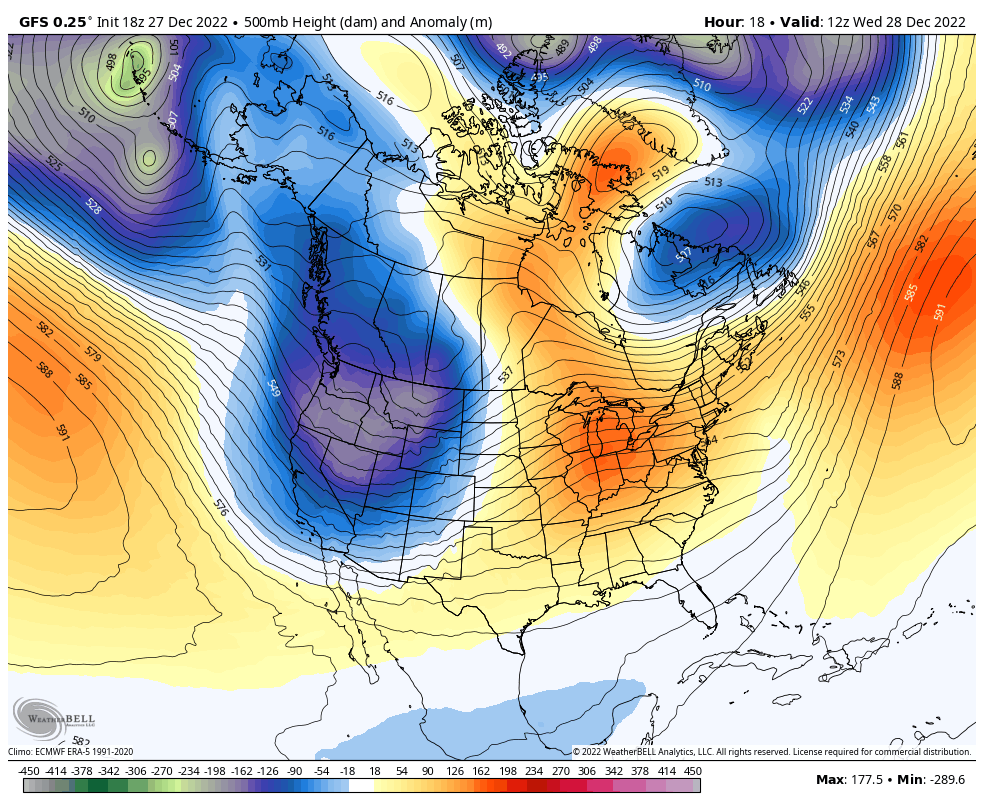
December 28 to January 10
The flow shows a flip to a warmer ridge for the Eastern US while periodic troughs will push into the Western US and occasionally flow our way. It is possible for one of these short waves to catch up with some colder air, so we are not completely forgetting about winter over the next two weeks.
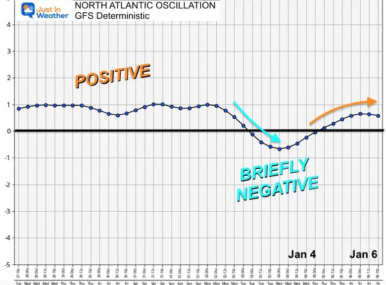
The North Atlantic Oscillation is a far more direct influence on our cold potential in winter. A Negative Index tends to bring us colder air masses. You will see the bulk of the next week will have a Positive Index.
I need to reinforce the Chaos Theory here: Farther out in time, small details can be missed now, which can lead to a large error later.
Here we see only a brief negative index around January 4, only to return positive.
This model, which has a better reputation for longer range accuracy has a different solution. This shows an index settling back to neutral and then trending negative January 4 to 6.
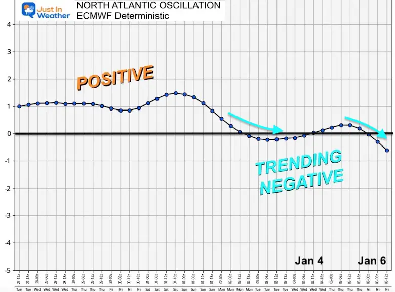
Keeping with the ECMWF Model, we see this settling back to neutral and then trending negative January 4 to 6.
How does this reflect on the computer model guidance?
Do you recall a week ago I showed you this model that pushed 72ºF for New Year’s Day? Then a day later it dropped to the 20s? Well, the warmer solution was on to something, but closer to 60ºF is what we are more likely to see.
Long range forecasting is low confidence and can abruptly change with new data, so I would not put too much stock in the end time period.
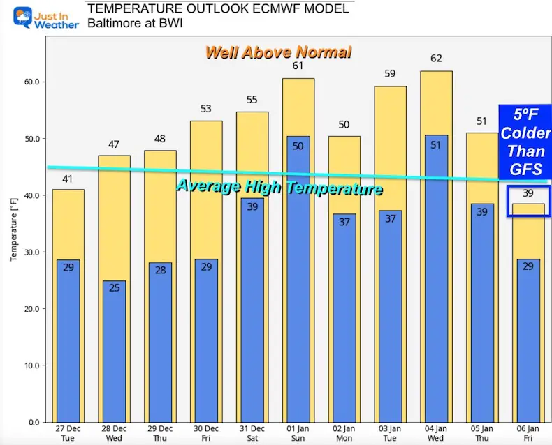
However, I want to show you how different the GFS and ECWMF models are looking into the first week of January.
It is very likely we warm into the 60s on January 1, and perhaps another day or two during the first week of the year.
This plot goes through January 12, with a trend closer to average for the second week of the month.
This plot only goes though January 6th.
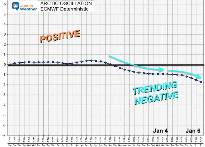
This is a subdued a little, but also shows at least two days reaching into the lower 60s during the start of January. For the end of this outlook, it is more subdued and responding to the Index trending Negative for the NAO and AO. By January 6 this model is below average AND looks to be 5 degrees cooler than the GFS.
I still DO NOT have confidence in winter storm forecasting beyond 1 week. In fact both models showed a snow storm for next week as recently as yesterday, but now it much less impressive.
I believe the same can be said for temperatures. I do not subscribe to specifics. We are just too limited with our math and computing capabilities to accurately account for all details and project 2 weeks into the future with high validation.
But the trends on a global scale having more reason need to be considered.
Warmer start to January, YES!
End of Winter: NO!
There are signals it will make a return in the middle of the month.
When I see it in the modeling with more substance, I will also suggest the trend we’ve been seeing often, that cold air arrives a little later than first shown.
If you have Faith in the Flakes, so do I. For now, we get a reprieve from the arctic cold. There will be more and I will be on the lookout.
FITF

December 5th Snow In Baltimore And The Start Of Faith In The Flakes FITF

Click to see more and ‘Book’ a visit to your school

I see many factors to support colder influence with multiple systems. Early and later in winter. Check it out.
Winter Outlook 2023 For Snow Not Typical La Niña Plus Polar Vortex Disruption
Atmospheric Memory Suggests Active Winter Storm Pattern Outlook
Winter Outlook 2023 From NOAA Very Different Than Farmers Almanacs
Winter Outlook 2023 Early Look At Snow From Two Farmers Almanacs
If you want a snowy winter, this is what you might want to look for in the rest of the tropical season. (You might be seeing a lot of commercial snow removal people out this Winter).
Record August For No Named Tropical Storms: Closer Look At Snow Following
Winter Weather Folklore Top 20 And More Outlook Signals From Nature For Cold And Snow
