


May 19 Weather Sunday Starts Foggy The Warming With Sun And Summer Heat On The Way
Sunday May 19 Morning Report The aftermath of the rainy Saturday is plenty of leftover moisture. This has left us with a bit of humidity and areas of thick fog…
December 20 2022
Tuesday Night Update
A few things I want to address in this storm update includes the source of our arctic air and the faster speed. Perhaps the cold dense air was not fully respected by the models, which did not account for the forward speed. The result will allow for more snow and mix inland when it begins on Thursday.
While we will be warm and get mostly rain, the Flash Freeze I have been advertising does appear to also be fitting the trend to arrive earlier. In fact much of central and western Maryland will drop below 32ºF before noon.
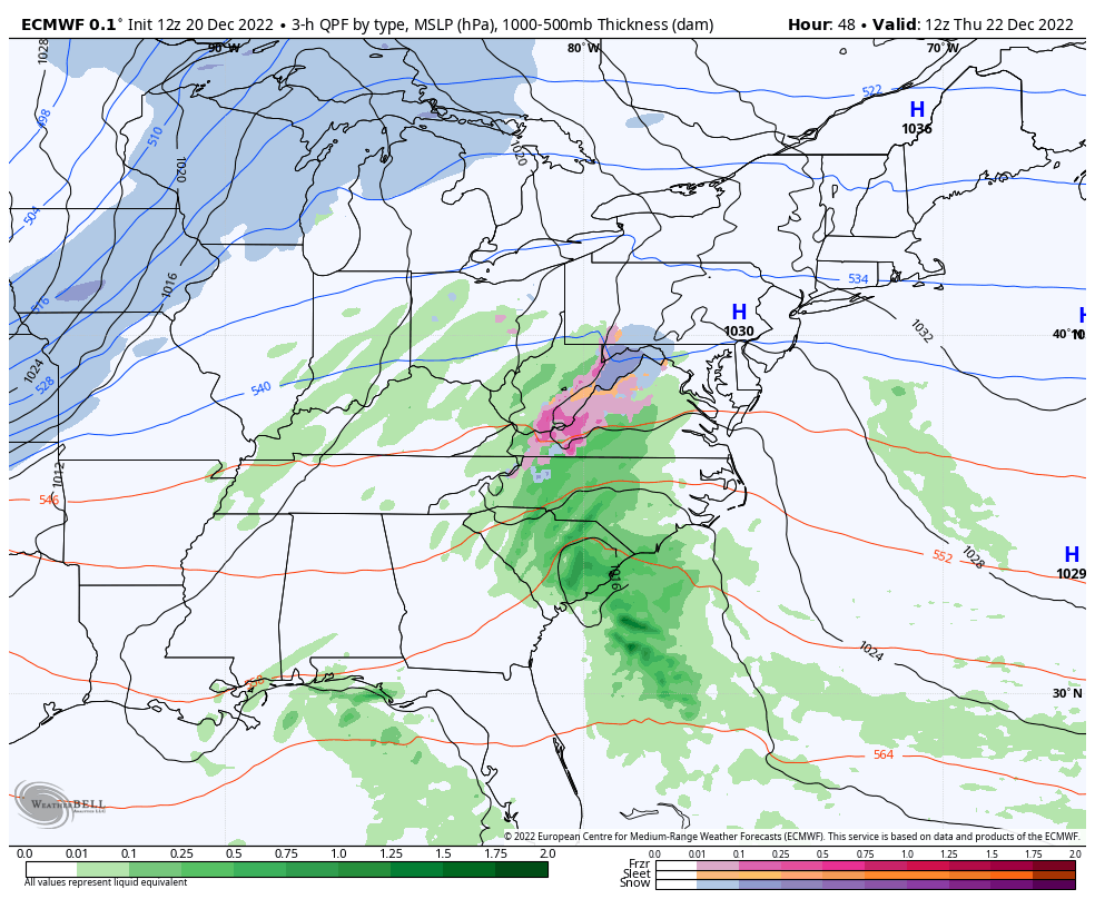
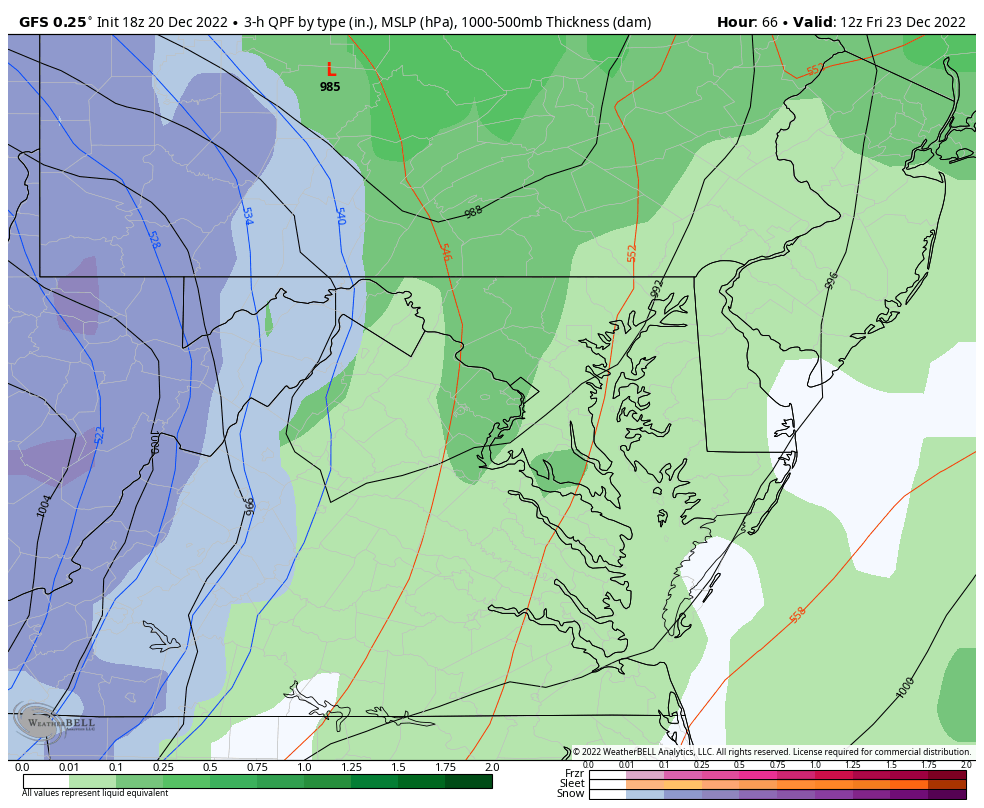
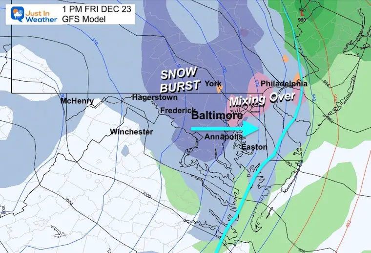
There does appear to be more of a burst of snow on the GFS Model, in response to Low Pressure along the arctic front. This may produce a dusting to 1 inch of snow. But more importantly, it will keep moisture on the pavement to allow a freeze. The maps below help tell the story.
Notice the -40s and -50s in Western Canada! It will not get that cold here, but that is the source of the force that will push that air mass in faster.
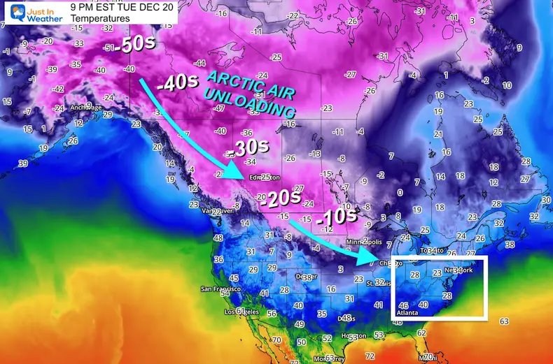
We can see that cold air mass from Western Canada drop into the eastern US.
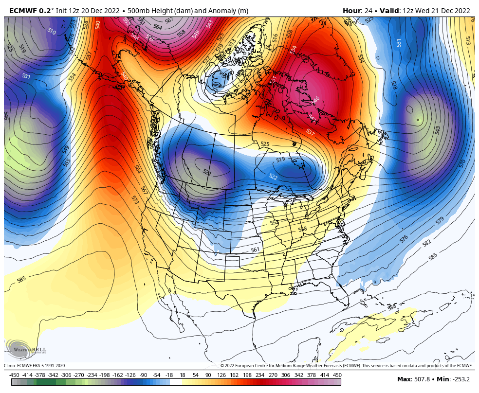
Note: The European Model has trended a little farther south with the Upper Low. This will enhance the arctic air and perhaps some snow we get!
In my prior report I answered two common questions about this event. Both will be validated over the next few days.
In short, a storm is low pressure, and a deeper storm has lower numbers of atmospheric pressure we measure in millibars (mb). When a storm gets stronger, the mb are lower numbers, which we say are ‘dropping’.
A Bomb Cyclone is defined as a storm dropping more than 24 mb in 24 hours, or more than 1mb per hour for a day. See my report here for the maps that prove this.
This is when arctic air arrives and turns wet pavement to ice. We expect temperatures to drop by midday on Friday. The challenge is if the pavement will remain wet as the temps drop, to allow ice to form on roads. Or, will the cold wind evaporate that wet pavement, drying it up before it has a chance to freeze?
I will show below how this will happen in the morning for most of us, increasing our chance to ice up the roads.
Let’s break this down into the cold parts with a closer look.
Much like all the systems in the last three months, this one will arrive earlier than model projection. That will allow cold enough air (mostly in the mountains) to produce a mix or snow.
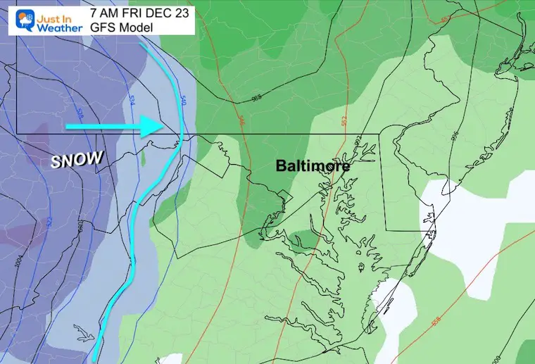
Most likely the leading edge will be west of Frederick. Light snow may fall over Hagerstown, Winchester, and the higher mountains.
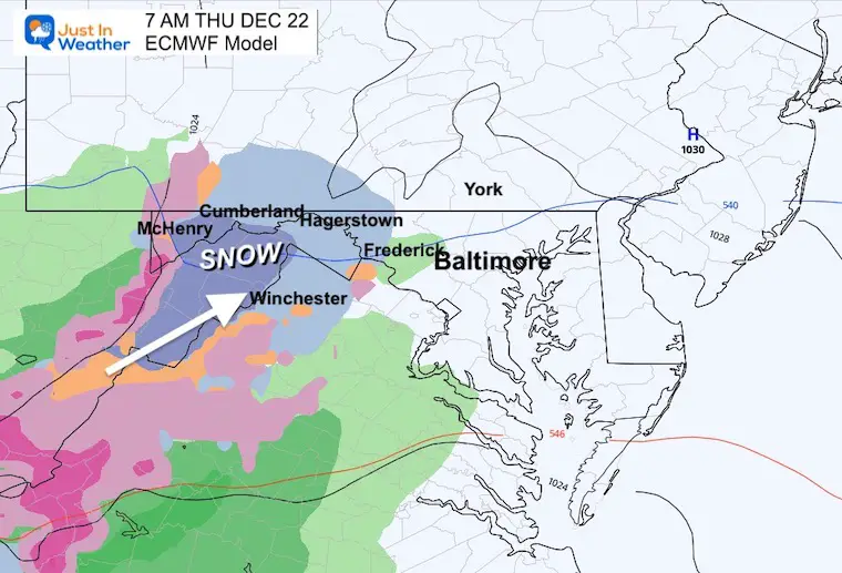
I’ve highlighted the freezing line to show that Hagerstown will barely be at freezing, but I-81 and west could have some slick roads.
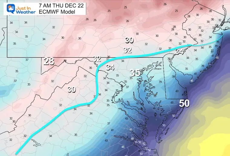
Heavier snow may briefly fall from Harrisburg to Hagerstown and in the mountains just west of I-81.
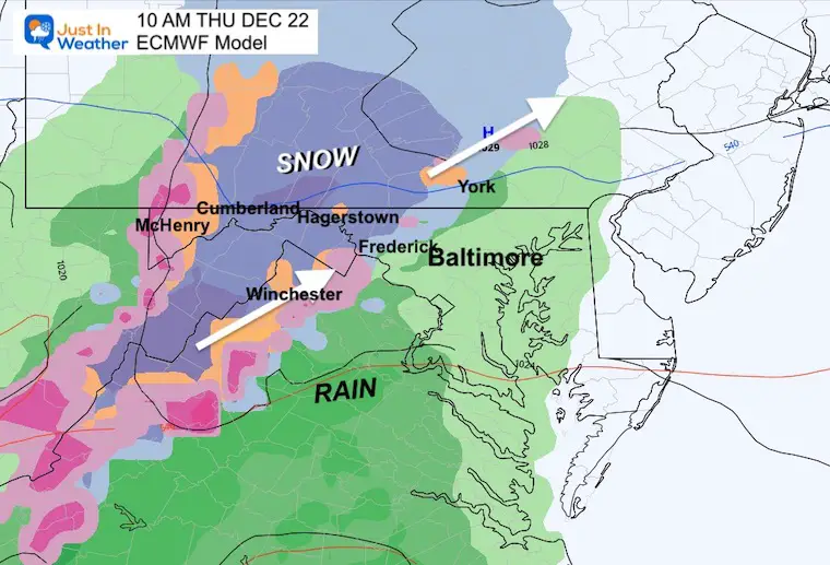
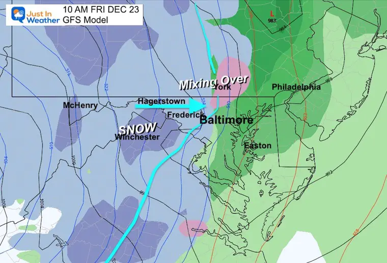
The snow areas may persist into the early afternoon. However, if there are road problems in the morning, the highways will likely be treated and passable by noon.
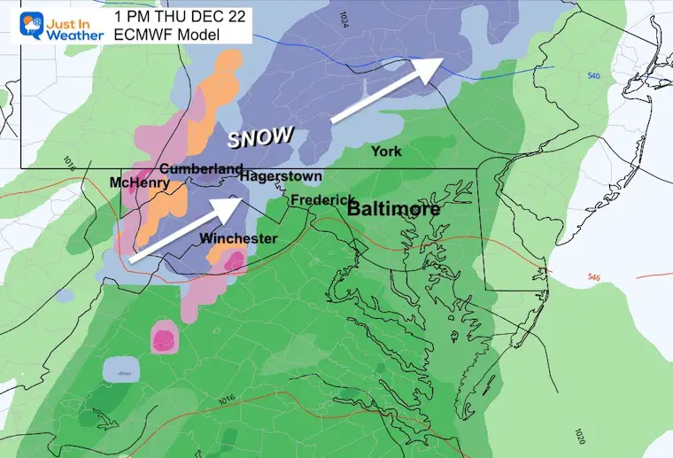
Most of our region will be in the rain by this time. Some lingering snow and ice could persist between Cumberland, Frostburg, and McHenry.
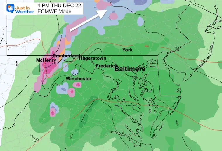
Note: There will be some heavy rain with over one inch in places west of the cities.
This will be a dramatic arctic ‘Ana Front’. That means precipitation will be falling behind the front as the sub freezing temps catch up.
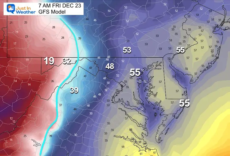
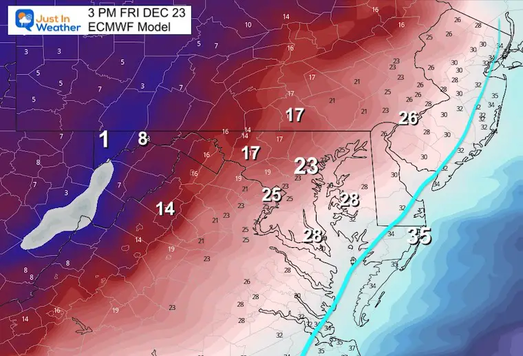
Check out this contrast from 19ºF in McHenry, 32ºF reaching Cumberland, while 55ºF between Baltimore and Ocean City.
Snow will be falling in the mountains at this time, while a surge of rain will be in the warmer air ahead of the front.
The arctic air will be moving east in a hurry! By this time 5ºF in McHenry and 25ºF in Frederick, and 30ºF in Westminster. This is the rapid drop and Flash Freeze Concern.
It may take an hour or so for wet pavement to freeze, but with snow falling it will have help.

It should be snowing in Frederick and changing over in York.
Metro Baltimore will be next – BEFORE NOON!
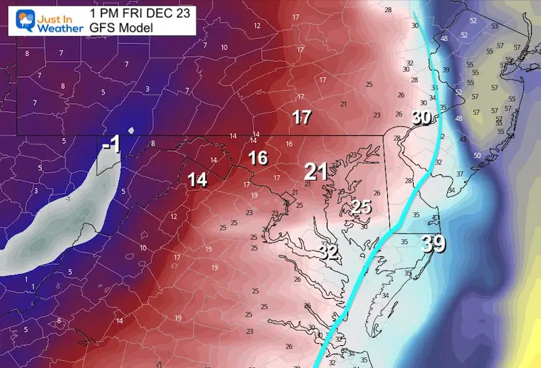
Temps in McHenry drop to -1ºF! Frederick to 16ºF, while Baltimore crashes to 21ºF and even the mid 2os reaching Easton.
I know temps tend to not drop as fast as models show, but even if this is off by a few degrees, it will still be a BIG DROP IN A HURRY!
A burst of snow may occur over central Maryland, with rain changing to snow showers around the Chesapeake Bay.
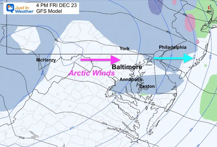
Philadelphia gets in on the action after midday.
Temps dropping to the TEENS in Baltimore and Southern Maryland? It is possible, while mid 20s reach the beaches!
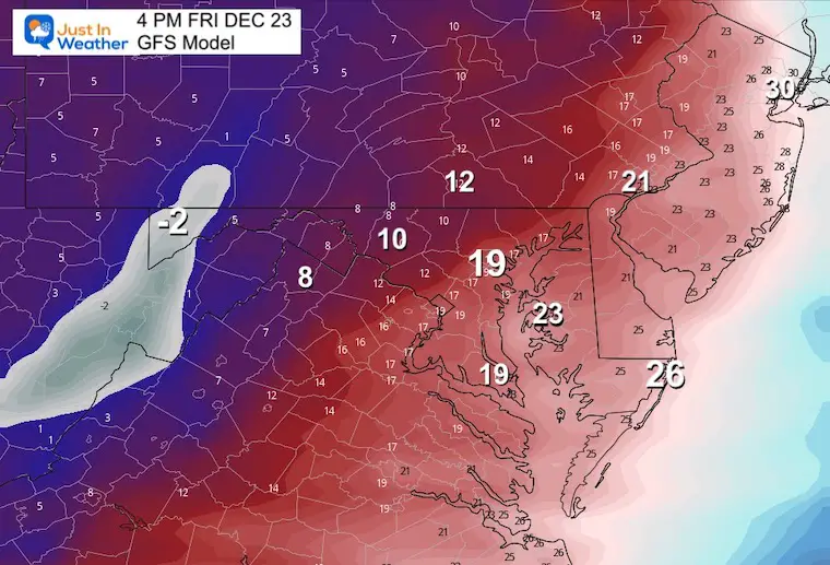
The bulk of the system will be gone at this time, but flurries and snow showers may persist.
Again, falling temps can be exaggerated on modeling, but even adding 5 degrees to this is still very impressive.
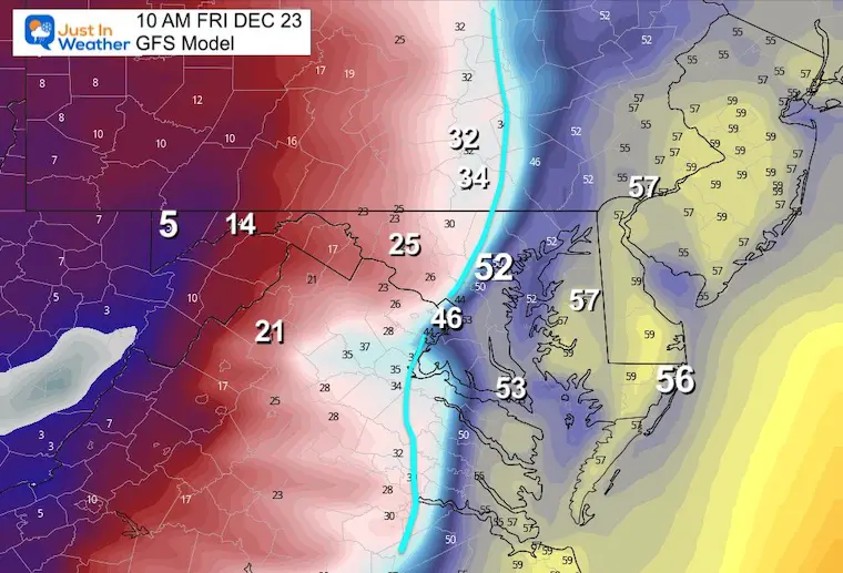
This is to show the similarity to the GFS Model. It is NOT indicating Wind Chill.
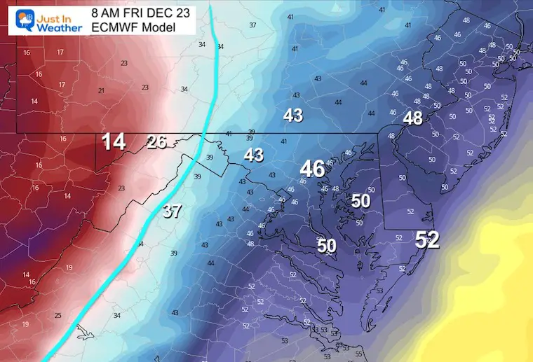
McHenry drops to 14ºF, while 40s remain from Frederick to Baltimore. The Eastern Shore is in the 50s.
McHenry drops to 5ºF, 14ºF in Cumberland, and the FREEZE reaches Frederick with 25ºF.
The 50s remain in Baltimore (not for long) to Delmarva.
The freezing line reaches Baltimore and Washington DC around this time.
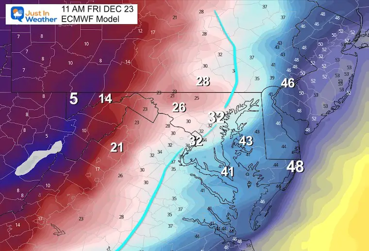
Temps remain near freezing along I-95 between Washington, Baltimore, and Wilmington. This is a little slower than the GFS Model, but still pushes that freeze in by noon.
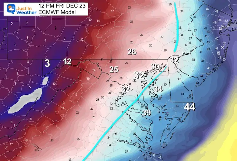
McHenry at 1ºF, while teens reach Frederick and York.
Baltimore drops to 23ºF, and the 20s reach Southern Maryland and Easton. The beaches are on the verge of getting into the freeze!
Note:
I support the notion of cautioning travel for potential Flash Freeze mid morning to early afternoon.
If you have night plans, main roads should be treated and passable. The few hours in the transition to arctic air will be tough.
I will refine details in my reports on Wednesday.
I wrote ‘mostly rain’ for Thursday, but this is for metro Baltimore. Let’s watch the icing potential for inland. 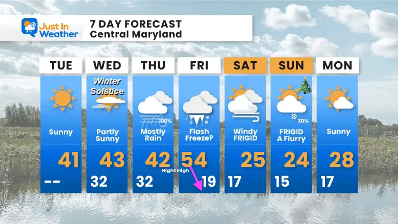

December 5th Snow In Baltimore And The Start Of Faith In The Flakes FITF

Click to see more and ‘Book’ a visit to your school

I see many factors to support colder influence with multiple systems. Early and later in winter. Check it out.
Winter Outlook 2023 For Snow Not Typical La Niña Plus Polar Vortex Disruption
Atmospheric Memory Suggests Active Winter Storm Pattern Outlook
Winter Outlook 2023 From NOAA Very Different Than Farmers Almanacs
Winter Outlook 2023 Early Look At Snow From Two Farmers Almanacs
If you want a snowy winter, this is what you might want to look for in the rest of the tropical season. (You might be seeing a lot of commercial snow removal people out this Winter).
Record August For No Named Tropical Storms: Closer Look At Snow Following
Winter Weather Folklore Top 20 And More Outlook Signals From Nature For Cold And Snow
