


May 9 Cooler With Rain And Severe Storm Risk Tonight South
Thursday May 9 Morning Report Today is the first day of the year with sunrise before 6 AM in Baltimore, but we won’t see it. After a high temperature of…
December 19 2022
Monday Evening Update
We are now within 3 days of the start of this storm for us on the East coast, and it is starting to come together with higher confidence. At this point, if you continue to follow my updates I hope to guide you for what I see with consistency and trends. I want to do things a little different in this report. First, some quick notes and answering the most common questions I’ve been getting. Then a look at the model maps below will help support my answers. Also, a very interesting Meteogram that shows how the snow projections from one model have changed each day since last Thursday.
Here is what jumped out to me today:
Quick Take: This large storm will bring our region mostly rain at the start, despite some inland mix. The main event for us will be Friday as the arctic air moves in. This may be late morning to midday, and catch up to the moisture for two important factors:
The latest models seem to speed up the arrival, which falls in line with many events I have shared with you over the last few months. We should hedge our bets on the faster time frame with this.
I feel good about these ideas, but the specific timing is still hard to pin down this early. Here is an example why:
If we can plot the leading edge of arctic air now (Monday) and miss the exact speed by just 1 mph, then it would be off by 24 miles each day. So by Friday afternoon, it could be 90 to 100 miles off. If this was moving at roughly 20 mph, that 100 miles could make the difference of five hours sooner or later.
The latest models have sped up the arrival of the arctic air to late Friday morning. It still may have some fine tuning that is best to start working on within 2 days of the event.
In my experience, the holiday travel is congested enough to cause problems. This storm will affect a large part of the Eastern US. It’s best to prepare for a delay regardless of the rain, wind, or snow in your travel airport. Flights can get delayed due to the weather in some other location holding up the connection.
This is when arctic air arrives and turns wet pavement to ice.
I realized last week we had a freezing rain event, but the ground was just warm enough to stay wet. Since then we have had a lot of nights below freezing to chill the ground. It can freeze faster now.
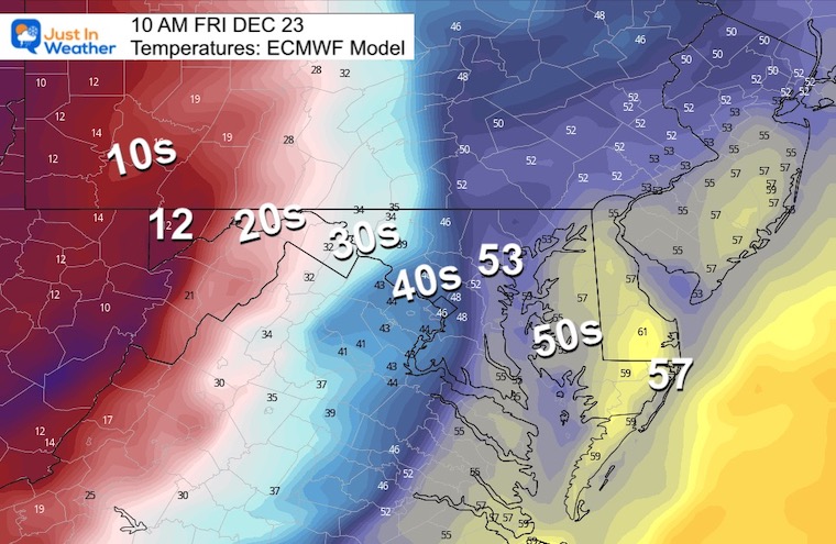
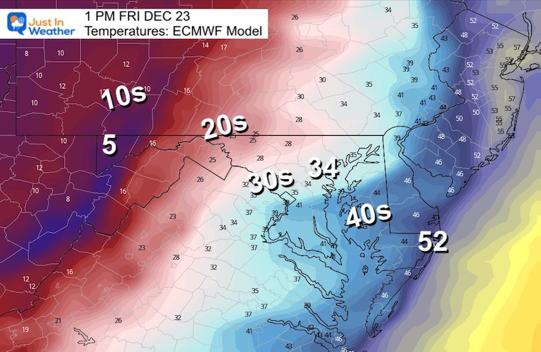
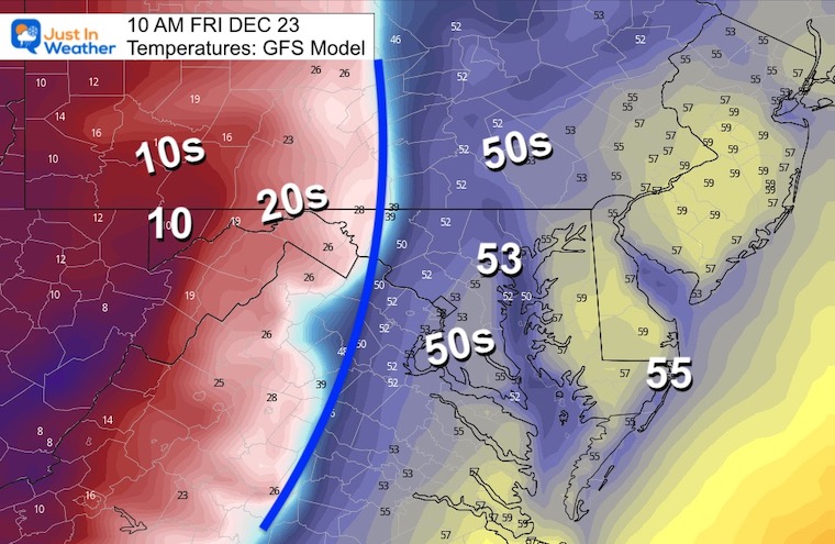
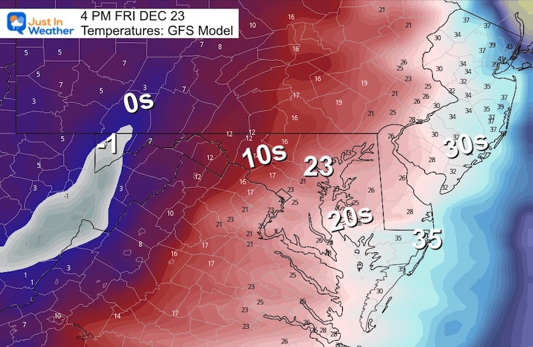
The models below are showing temperatures dropping quickly from the 50s to below freezing, perhaps the 20s within two hours. Also, there will be moisture left over, with the GFS showing a few hours of potential snow while in the freeze.
Let’s take a look…
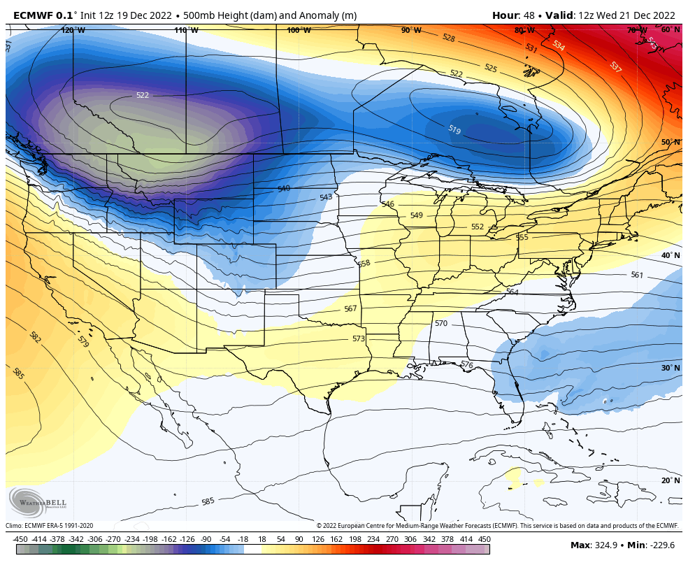
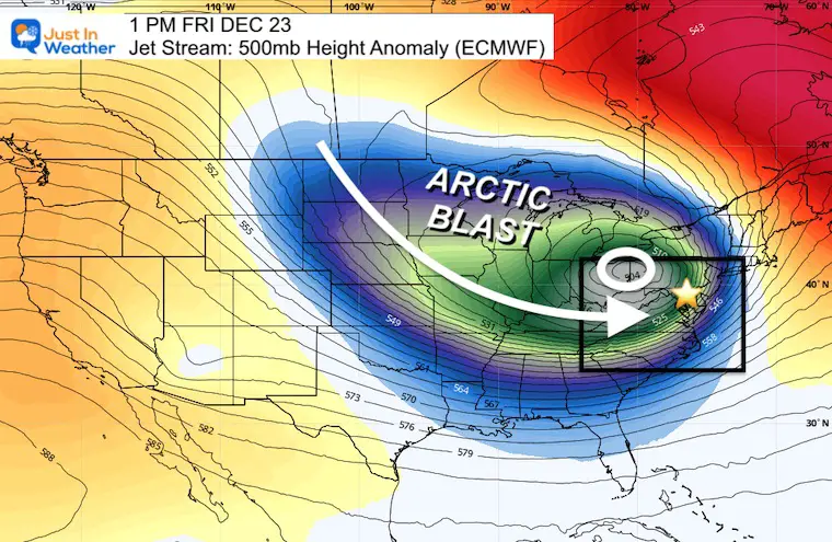
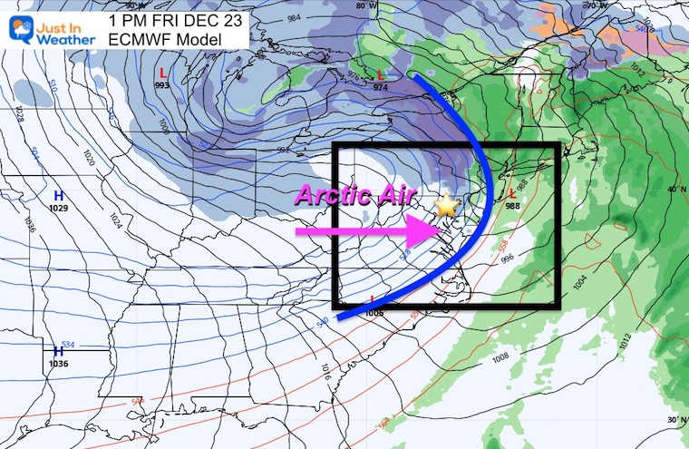
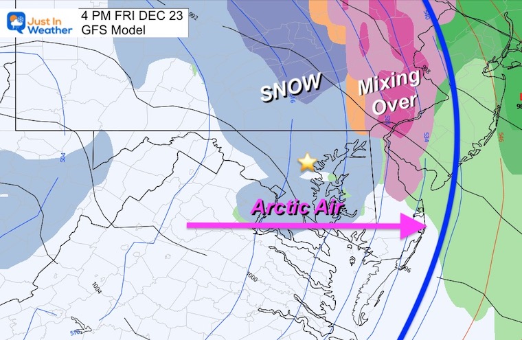
The White Circle is the Closed Upper Level Low. This will pass through Pittsburgh and Buffalo. It will push the arctic air through our region, but the debate is whether there will be moisture left or not.
Often with this set up, we get the arctic air as the rain ends. In this case, it looks like we could get this to catch up for a few hours.
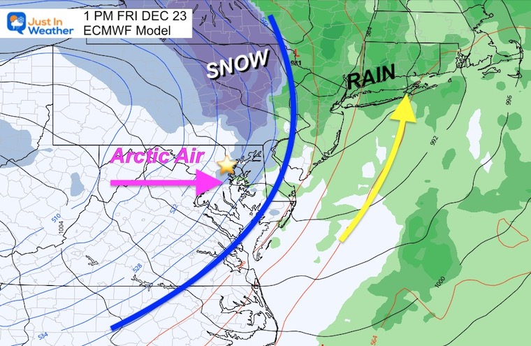
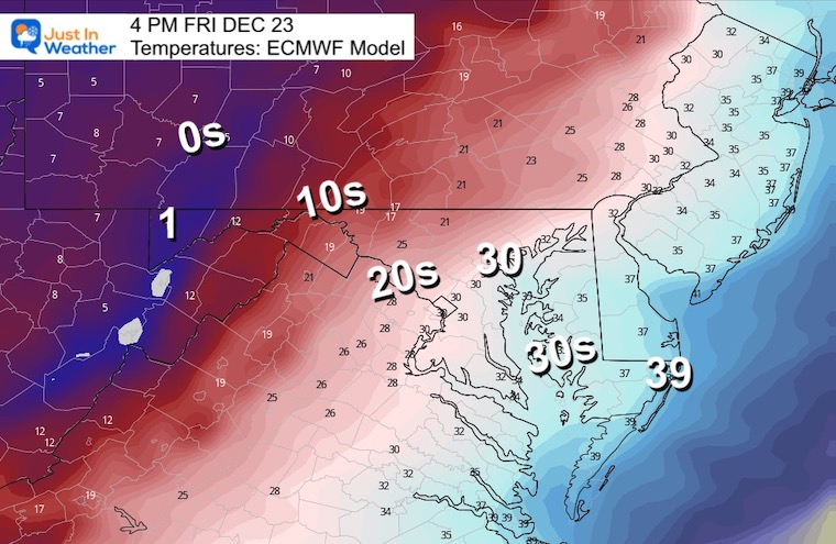
I am starting with the European Model, since it has been the most consistent.
I need to emphasize, this is faster that the previous model runs. This has the arctic front reaching east of Philadelphia by 1 PM.
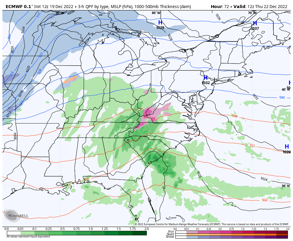
There is not a lot of moisture but it does show some snow in the cold air for 1 to 3 hours. It may not accumulate much in metro areas, but could be enough to keep the roads wet as the deep freeze arrives.
Yes, the winds will be strong and help to dry out roads (if not raining or snowing).
Steady winds 15 to 25 mph, with gusts 30 to 40 mph.
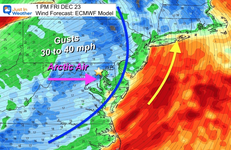
(readings on the thermometer NOT Wind Chill)
WOW!
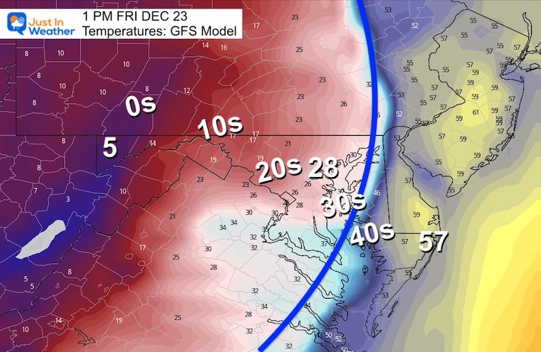
I want to reinforce that this model as recently as last night was delaying the cold air until the evening. It is now sooner and keeps more moisture around in the cold air. It is a worst case scenario, but still a bump from before. I want to see consistency or the ECMWF Model to trend this way before I bite.
However, most weather apps use this model, so this may reflect what you have been seeing.
Front moves East of the Chesapeake Bay with a wintry mix (pink) from Baltimore to Cecil County.
Sleet (orange) and Snow (blue) extend from the western suburbs to western Maryland mountains. This supports a few hours of precipitation in the freezing air!
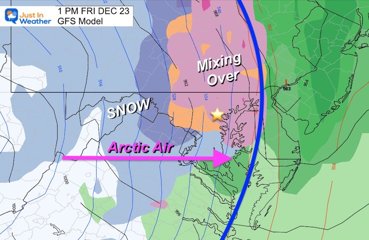
This supports snow showers and flurries through metro Baltimore and within 50 miles in all directions, at least for the 1 PM to 4 PM time fame. This may NOT amount to much accumulation, but maybe enough to keep roads wet as the cold air catches up. That is the concern for the Flash Freeze, and the GFS Model makes it look more likely.
I am just showing Saturday Morning, but this is like to repeat for Christmas Day as well.
Baltimore reaches the mid Teens, with Ocean City and coastal areas in the Mid 20s.
This is now showing up in the 7-day Forecast which will be updated in my Tuesday morning report.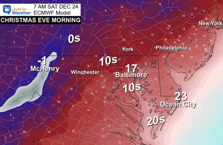
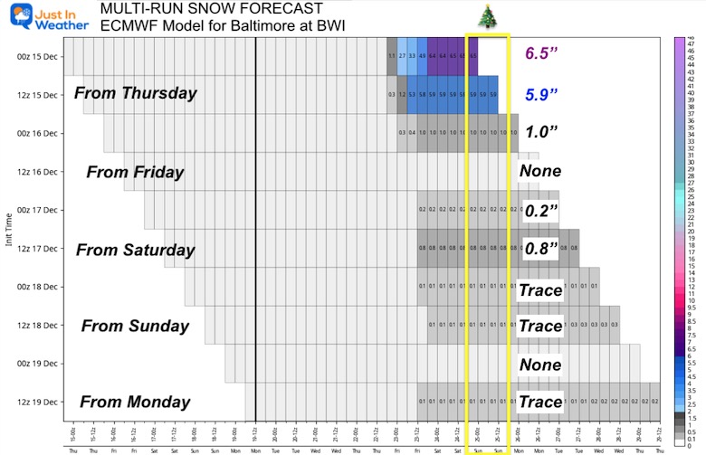
I thought this meteogram was good to share now. Here is a look at the Snowfall forecast for Baltimore on all ECWMF Model Runs since last Thursday (from top to bottom).
Remember when many were talking about a big snowstorm and I was hesitant, because I don’t trust modeling one week away. Also, I NEVER give snow totals more than 3 days away. This is why! You almost have to laugh at the adjustment, but it does prove the Chaos Theory, and how missing small details can lead to big changes farther out in time.
From my perspective, this is the protocol I follow and I hope it helps as I dive into the updates and expectations.

December 5th Snow In Baltimore And The Start Of Faith In The Flakes FITF

Click to see more and ‘Book’ a visit to your school

I see many factors to support colder influence with multiple systems. Early and later in winter. Check it out.
Winter Outlook 2023 For Snow Not Typical La Niña Plus Polar Vortex Disruption
Atmospheric Memory Suggests Active Winter Storm Pattern Outlook
Winter Outlook 2023 From NOAA Very Different Than Farmers Almanacs
Winter Outlook 2023 Early Look At Snow From Two Farmers Almanacs
If you want a snowy winter, this is what you might want to look for in the rest of the tropical season. (You might be seeing a lot of commercial snow removal people out this Winter).
Record August For No Named Tropical Storms: Closer Look At Snow Following
Winter Weather Folklore Top 20 And More Outlook Signals From Nature For Cold And Snow
