December 18 2022
Sunday Evening Update
I just wanted to give a quick update on the winter storm for my overnight friends. I still believe it is a little too early for specifics, but with a little more consistency I have a little more confidence in the main influential parts of the weather event at the end of this week, and the arctic air that will arrive for Christmas weekend.
If this is your first time reading my posts, I will review my storm protocol at the bottom of this post. Please just know it is important to me to share information and NOT HYPE expectations. Once we see the Monday morning model package, I do believe we can start to refine with better likelihood for Thursday and Friday.
Quick Take: There will be a large storm with wide impacts across the US for planes, etc., Thursday and Friday. The main concern I see is Friday and timing out the arrival for the arctic air. This will determine both if we can get accumulating snow AND ALSO a Flash Freeze on roads. That may be the biggest concern for the holiday travel.
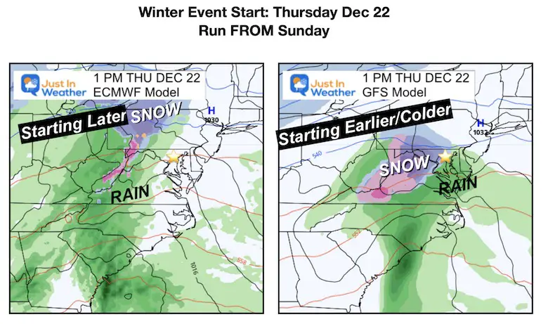
Latest Model Guidance Comparison
European ECMWF (LEFT) Vs. GFS (RIGHT)
I will take a closer look at the ECMWF Model below…
The ECMWF took the lead early, but the GFS has fallen in line with consistency from the prior few model runs (every 6 hours). The main difference I see now is the start time and precipitation type around central Maryland/Southern PA.
Starting Thursday
The ECMWF brings this in later on Thursday afternoon with mostly rain, but snow or mix now well west of I-81. The GFS is bringing this in mid-morning to early afternoon… But COLDER! It does have the snow line closer to metro Baltimore… I need to remind all of us again that the GFS also showed snow for this past Thursday’s event which did not happen. Something to consider….
Most of the storm for the Big Cities and the Coast will be rain! The snow and ice will be in the Great Lakes and Mid-west Thursday into Friday.
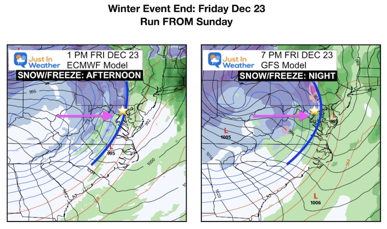
SKIPPING AHEAD (for now)
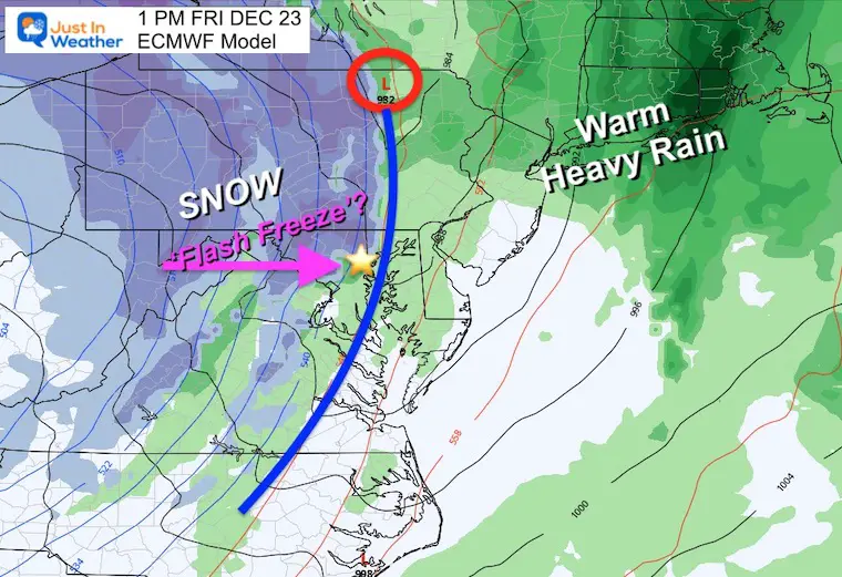
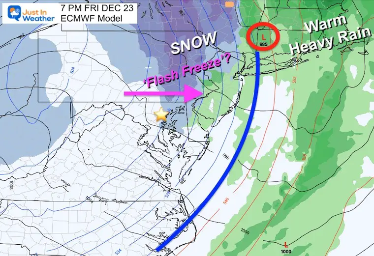
Friday Afternoon
The ECMWF continues to bring the arctic air in sooner! We see it through the Chesapeake Bay, catching up to the moisture by early afternoon. This brings a few hours of snowfall and a risk for flash freezing on roads.
The GFS is still about 6 hours slower with the progress of the storm complex. It brings in the freezing line to I-95 in Baltimore by 7 PM. However, a warm rain will continue a few more hours through Philadelphia, New York, and Boston.
Storm Animations
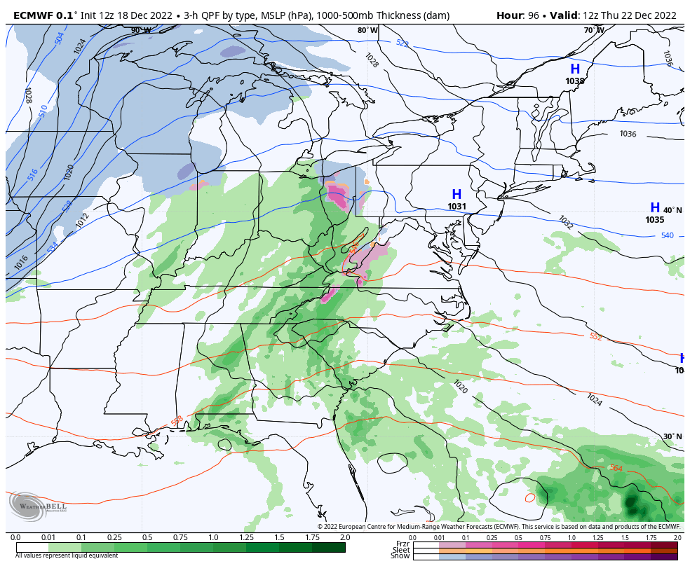
Since the ECWMF has been more consistent and has a better history of accuracy, let’s first take a look at how it handles the storm.
ECMWF
7 AM Thursday to 7 AM Saturday
This is a little faster and brings the core Low farther East. It allows the transition to colder air sooner, and allowing a few hours of that in place to drop snow to end the storm.
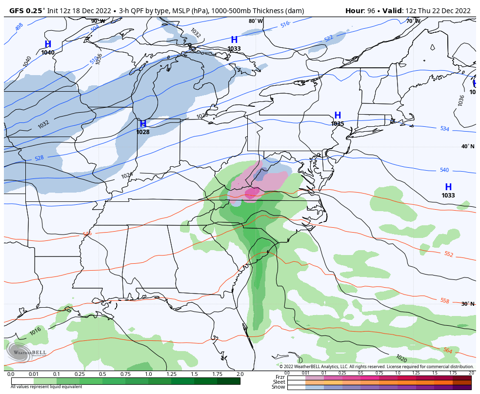
Compare to the slower GFS Model solution
GFS
7 AM Thursday to 7 AM Saturday
This is slower, allowing the core Low to move farther inland and keep the warmer air in longer. The result is more rain.
Closer Look at the ECMWF and My Thoughts
At this point, I think it is a safe call to continue to put the European Model at the lead. I am keeping my wild card for the earlier Thursday start with some snow or mix simply because many systems this Fall have arrived earlier than models projected.
Friday Afternoon
The cold front is shown reaching the Chesapeake Bay, with moisture still around to fall as snow for the last couple of hours.
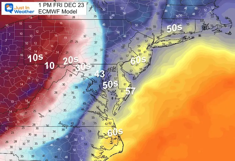
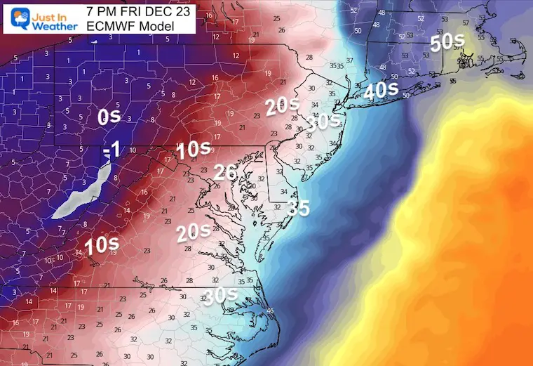
Temperatures at 1 PM
Now THAT’s a COLD FRONT:
- Ocean City = 57ºF
- Baltimore = 43ºF (Westminster and Frederick at 34ºF and falling fast)
- McHenry = 10ºF
The danger here is the potential for a Flash Freeze. This is when the air cools down so fast, that any moisture on roads can ice up before it has a chance to dry out.
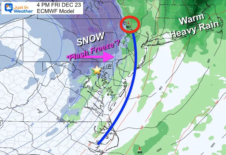
4 PM Snapshots
The cold front moves east of Philadelphia and Trenton, but along the New Jersey Turnpike not yet to New York City. The amount of falling snow is subject for debate in metro areas, but likely to end with stickage in The Poconos.
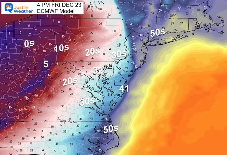
Temperatures
The freeze gets to the cities. Baltimore at 32ºF, with Ocean City at 41, and McHenry in western Maryland at 5ºF.
7 PM Snapshots
The cold front crosses New York and heads into New England.
Heavy snow in the Poconos, with heavy rain still in most of New England.
Snow showers near Baltimore likely to not amount to much, but anything to keep roads from drying out as the cold air settles in, allows for Flash Freezing.
Temperatures
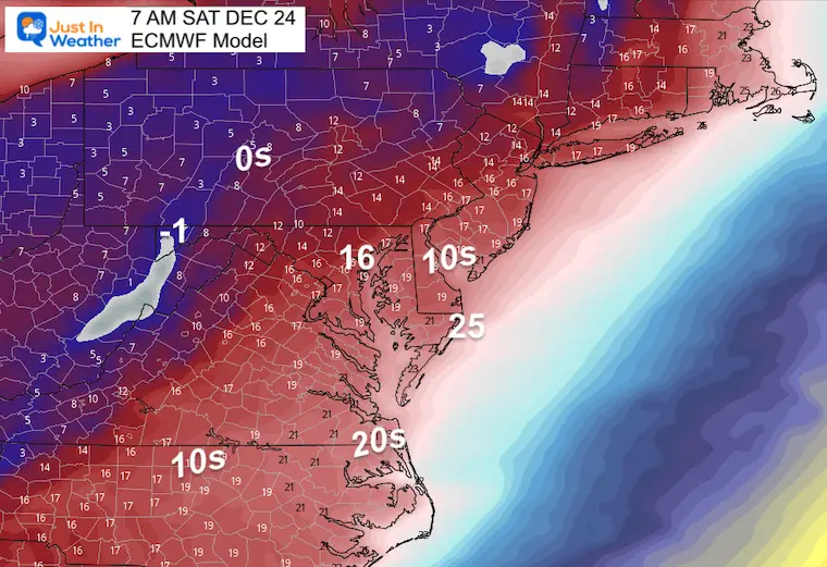
The deep freeze moves in!
- Baltimore = 26ºF
- Inland Suburbs = Teens
- McHenry = -1ºF
Christmas Weekend: VERY COLD
I am just showing Saturday Morning, but this is like to repeat for Christmas Day as well.
Baltimore reaches the mid Teens, with Ocean City and coastal areas in the Mid 20s.
I will have an update in my Monday morning report, then we get into more specific higher percentage details in the afternoon/evening.
Additional Notes On All Winter Storms
From my perspective, this is the protocol I follow and I hope it helps as I dive into the update and expectations.
- Never promise snow a week or more ahead of time. I carefully choose my words with possibly and model guidance trends. I did show this event a week and a day ahead of time with the caveat that it will be during high holiday travel and worth extra attention.
- Never flip a forecast based on one model run. Especially with this still being 5+ days away, there are a lot of small details that can be missed by computer guidance. Or a small shift early can lead to a 200 mile move of a snow line a week away.
- I continue to ‘look’ at guidance and share it with you to identify trends. These trends help to show which model is consistent or if there is new information that will trend timing or temperatures to be adjusted.
- Any snow or ice forecasting is more realistic within 72 hours (3 days) of the event. Until then it is not worth guessing.
- A large storm regardless of snow, ice, or rain locally, can still have wide ranging impacts for travel ahead of a holiday.
Faith in the Flakes Gear

What is Faith in the Flakes?
It began with my son in 2009
December 5th Snow In Baltimore And The Start Of Faith In The Flakes FITF
SNOWSTIX – Available Now

STEM Assemblies/In School Fields Trips Are Back
Click to see more and ‘Book’ a visit to your school

My Winter Outlook: Not A Typical La Niña!
I see many factors to support colder influence with multiple systems. Early and later in winter. Check it out.
Winter Outlook 2023 For Snow Not Typical La Niña Plus Polar Vortex Disruption
Also See The Winter Outlook Series:
Atmospheric Memory Suggests Active Winter Storm Pattern Outlook
Winter Outlook 2023 From NOAA Very Different Than Farmers Almanacs
Farmer’s Almanac Comparison
Winter Outlook 2023 Early Look At Snow From Two Farmers Almanacs
Triple Dip La Niña Winter
Winter Outlook 2023 La Niña Triple Dip Expectations
CONNECTION TO WINTER?
If you want a snowy winter, this is what you might want to look for in the rest of the tropical season. (You might be seeing a lot of commercial snow removal people out this Winter).
Record August For No Named Tropical Storms: Closer Look At Snow Following
Wooly Bear Caterpillars
Winter Weather Outlook From The Wooly Bear Caterpillar
Persimmon Seeds
Winter Weather Outlook: Persimmon Seeds And Snow Folklore
Click to see Top 20 and MORE
Winter Weather Folklore Top 20 And More Outlook Signals From Nature For Cold And Snow
Normals And Records: Maryland and Baltimore Climate History

Please share your thoughts, best weather pics/videos, or just keep in touch via social media


