December 17 2022
Saturday Night Update
There is going to be a major storm affecting travel leading up to the Christmas Weekend Holiday. That part is almost guaranteed, along with arctic air to follow for Christmas Day. The wrinkle is what will that storm bring us during that transition. The polar vortex, Greenland Blocking, and storm formation are all going to happen. Where exactly they track a winter storm is still in the works.
If you have been tracking models, weather apps, or other pages then you possibly have seen a scaling down of expectations. I am still in the mode of presenting the guidance to track trends, but too early for any promises or hyping if you will. Although some may see just a report as hype. I hope my words quell that.
From my perspective, this is the protocol I follow and I hope it helps as I dive into the update and expectations.
- Never promise snow a week or more ahead of time. I carefully choose my words with possibility and model guidance trends. I did show this event a week and a day ahead of time with the caveat that it will be during high holiday travel and worth extra attention.
- Never flip a forecast based on one model run. Especially with this still being 5+ days away, there are a lot of small details that can be missed by computer guidance. Or a small shift early can lead to a 200 mile move of a snow line a week away.
- I continue to ‘look’ at guidance and share it with you to identify trends. These trends help to show which model is consistent or if there is new information that will trend for timing or temperatures to be adjusted.
- Any snow or ice forecasting is more realistic within 72 hours (3 days) of the event. Until then it is not worth guessing.
- A large storm regardless of snow, ice, or rain locally, can still have wide ranging impacts for travel ahead of a holiday.
Quick Take:
There will be a storm with wide impacts of planes, etc., Thursday and Friday. Also, there will most likely be arctic air in place for Christmas weekend. Let’s take a look:
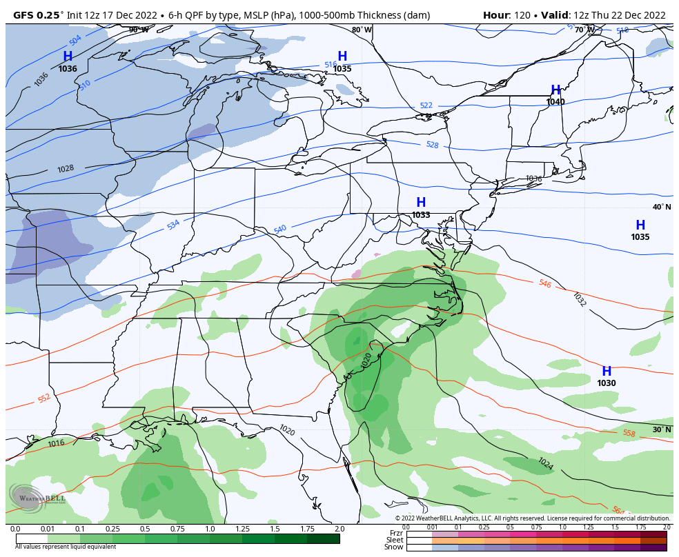
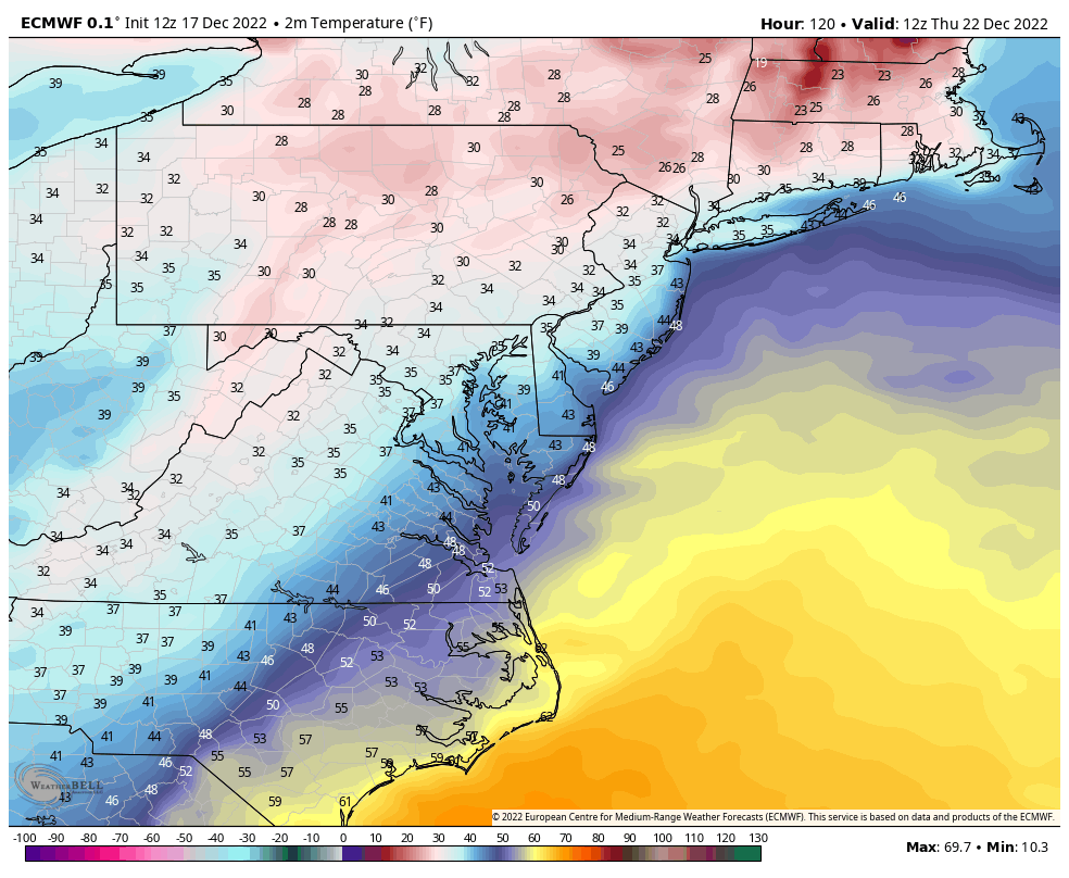
Latest Model Guidance Comparison
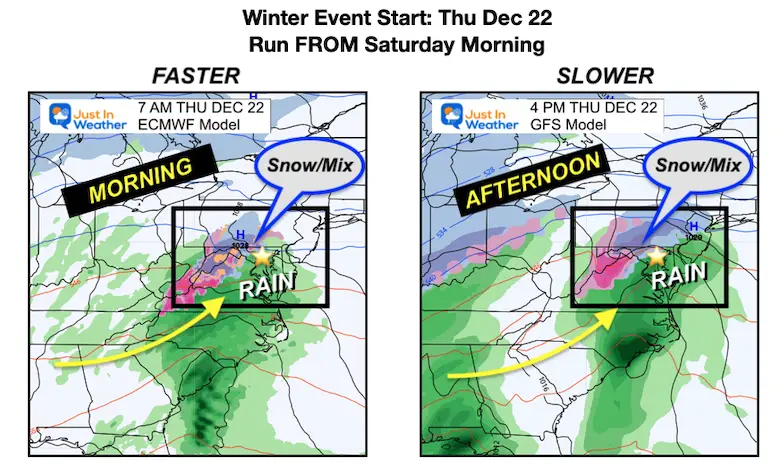
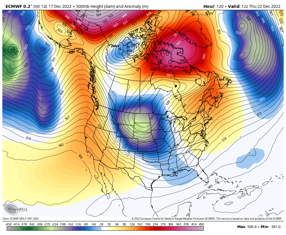
European ECMWF (LEFT) Vs. GFS (RIGHT)
The ECMWF has been more consistent. The GFS has made the abrupt change to slow down and allow warmer air in.
Starting Thursday
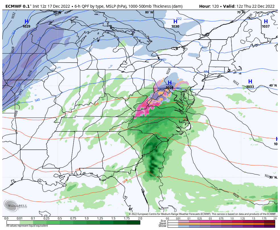
The ECMWF brings this in by daybreak Thursday with mostly rain, but snow or mix inland along and west of I-81. The GFS has slowed it down a lot from prior runs. This starts Thursday afternoon. It does have the snow line closer to metro Baltimore… But I need to remind you that the GFS also showed snow for this past Thursday’s event which did not happen.
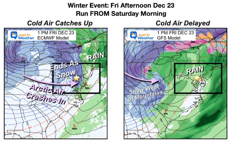
Friday Afternoon
The ECMWF brings the arctic air through the Chesapeake Bay, catching up to the moisture. It brings a few hours of snowfall and a risk for flash freezing on roads.
The GFS is much slower with the progress of the storm complex. This keeps the mild air in at this point, with the snow line west of the mountains.
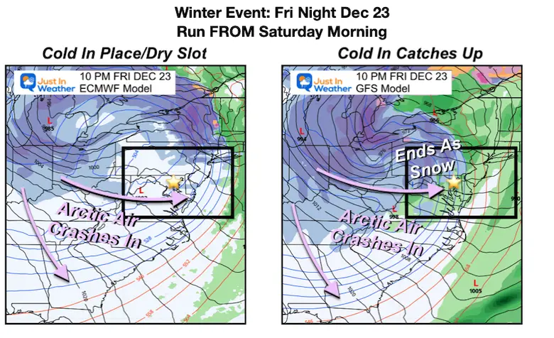
Friday Night
With the ECMWF being faster, it moves the storm out, ending the snow, and arctic air all the way to the coast. New England has the transition overnight.
The GFS Model has the rain to snow at this time period for central Maryland. The set up does not support a lot to fall and stick, but does also support flash freezing on roads.
Storm Animations
Since the ECWMF has been more consistent, let’s first take a look how it handles the storm.
ECMWF
7 AM Thursday to 7 AM Saturday
This is a little faster and brings the core Low farther East. This allows the transition to colder air sooner and allowing a few hours of that in place to drop snow to end the storm.
Compare to the slower GFS Model solution
GFS Model
7 AM Thursday to 7 AM Saturday
This is slower, allowing the core Low to move farther inland and keep the warmer air in longer. The result is more rain.
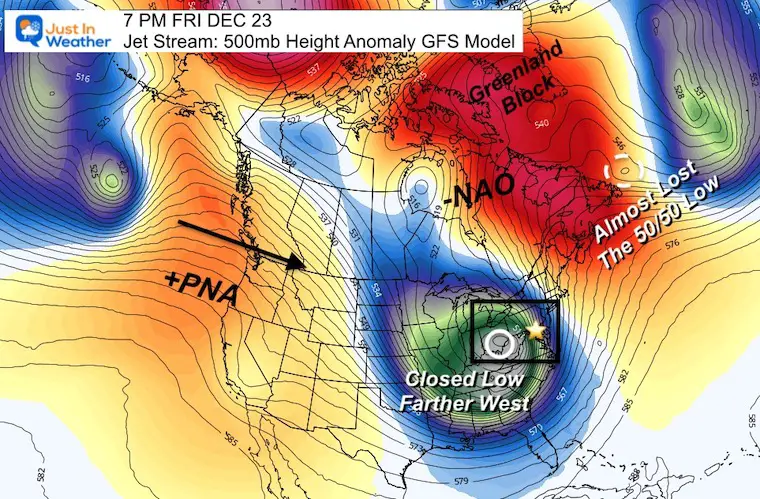
Jet Stream
The set up is similar to what we have expected for weeks. The difference from yesterday is subtle but profound. Yes, we have a Strong NEGATIVE North Atlantic Oscillation (-NAO), and POSITIVE Pacific North American Index (+PNA).
In addition to The Greenland Block, another feature that helps with holding cold air in for the Mid Atlantic would be anther closed Low at 50N and 50W. This is the 50/50 Low located near Newfoundland, Canada.
GFS Model
The GFS has almost lost that Low, in addition to the +PNA not being as strong as the prior runs. This small detail has resulted is a very big difference with how this model presented the storm development.
ECMWF Model
This has that 50/50 Low, but farther EAST. This is not a strong force, but more than the GFS to allow some of the influence in.
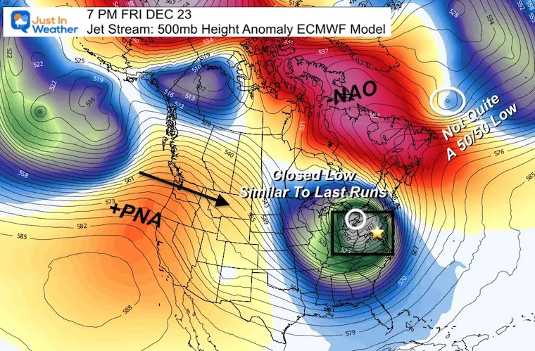
Animation
Jet Stream 7 AM Thursday to 7 AM Tuesday
With the ECMWF Model being more consistent, let’s look at that animation flow.
The end frames show both cold air holding AND another short wave… Hinting that another system is possible AFTER Christmas.
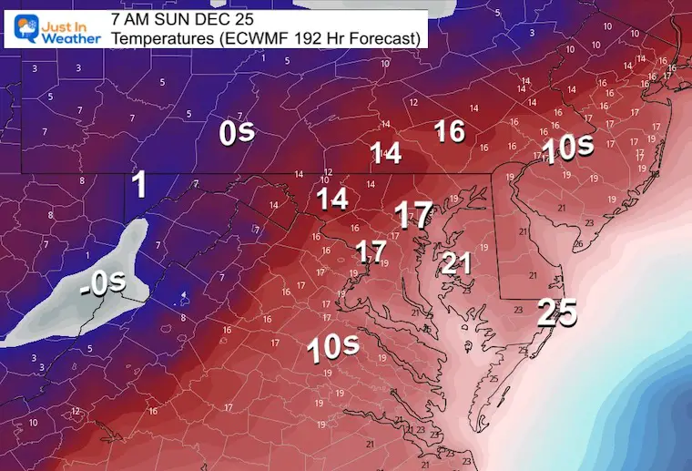
Arctic Temperatures This Weekend
ECMWF Model 7 AM Thu Dec 22 to 7 AM SUN Dec 25
Watch how the little bubble of ‘just warm enough’ air moves in, then the force of the arctic air for Saturday through Sunday (Christmas) morning.
C-c-cold Christmas
These are the forecast Low Temperatures Christmas Day. If this verifies, the Teens will reach Baltimore and the Bay, with the mid 20s t0 Ocean City. Back inland, barely above Zero in Deep Creek Lake.
My Thoughts:
There is still a lot of room for adjustment as the energy is still days away. The ingredients have not formed yet and I expect as the small details are refined, so will the expectation for the fine line of timing and freezing precipitation.
The pattern supports ‘something’! It will impact a lot of people and true winter should be felt Christmas Weekend! Keep Thursday and Friday in mind for any adjustment to your schedule. I have one of my largest school visits planned for Thursday, so personally I am rooting for the timing to change. But I am in a holding pattern as well.
It will get cold and winter is just beginning. It looks like it will be busy!
Faith in the Flakes.
Faith in the Flakes Gear

What is Faith in the Flakes?
It began with my son in 2009
December 5th Snow In Baltimore And The Start Of Faith In The Flakes FITF
SNOWSTIX – Available Now

STEM Assemblies/In School Fields Trips Are Back
Click to see more and ‘Book’ a visit to your school

My Winter Outlook: Not A Typical La Niña!
I see many factors to support colder influence with multiple systems. Early and later in winter. Check it out.
Winter Outlook 2023 For Snow Not Typical La Niña Plus Polar Vortex Disruption
Also See The Winter Outlook Series:
Atmospheric Memory Suggests Active Winter Storm Pattern Outlook
Winter Outlook 2023 From NOAA Very Different Than Farmers Almanacs
Farmer’s Almanac Comparison
Winter Outlook 2023 Early Look At Snow From Two Farmers Almanacs
Triple Dip La Niña Winter
Winter Outlook 2023 La Niña Triple Dip Expectations
CONNECTION TO WINTER?
If you want a snowy winter, this is what you might want to look for in the rest of the tropical season. (You might be seeing a lot of commercial snow removal people out this Winter).
Record August For No Named Tropical Storms: Closer Look At Snow Following
Wooly Bear Caterpillars
Winter Weather Outlook From The Wooly Bear Caterpillar
Persimmon Seeds
Winter Weather Outlook: Persimmon Seeds And Snow Folklore
Click to see Top 20 and MORE
Winter Weather Folklore Top 20 And More Outlook Signals From Nature For Cold And Snow
Normals And Records: Maryland and Baltimore Climate History

Please share your thoughts, best weather pics/videos, or just keep in touch via social media


