


May 6 Morning Fog Then Rain Returns Tonight
Monday May 6 Morning Report The pattern remains soggy with dense fog this morning. The next round of rain will return tonight into Tuesday morning. Then it should break up…
December 14 2022
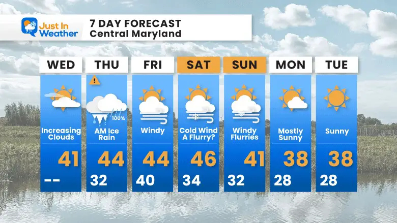
Wednesday Morning Update
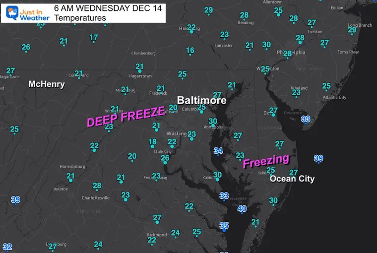
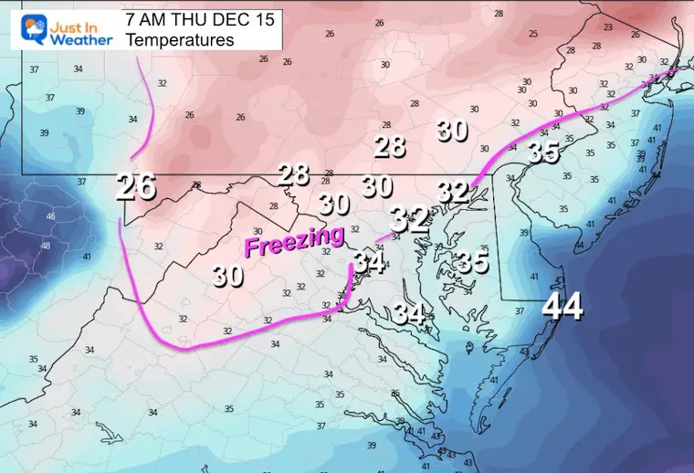
It is going to feel like a winter storm is on the way. Very cold air is in place this morning, in fact colder than expected for some areas. That is important to chill the pavement ahead of our event. Much of that pavement has already been pretreated in anticipation of the sleet and freezing rain tomorrow.
Morning Temperatures
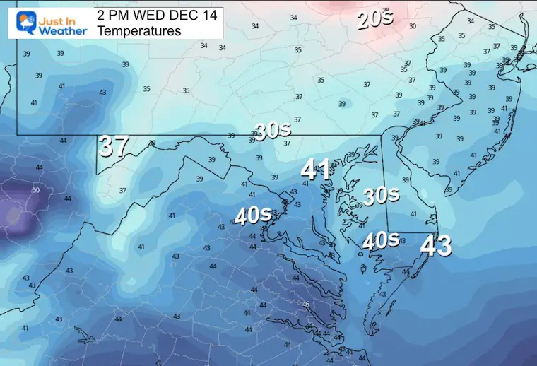
Today will be dry, but clouds will dim any morning sunshine, and help to limit heating of the roads. The net result may be a little more icing impact Thursday morning. More on that storm and into Christmas week below.
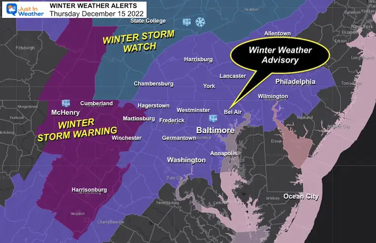
Winter Weather Advisory – Primarily for Sleet and Freezing Rain (some snow north)
Central Maryland North and West Of the Bay including Annapolis to Washington.
Southern PA – More sleet and freezing rain
Winter Storm Warning – Ice Storm may bring 1/2″ ice or more from Martinsburg and Winchester to Cumberland and Garrett County.
Winter Storm Watch for more snow – State College to the Poconos.
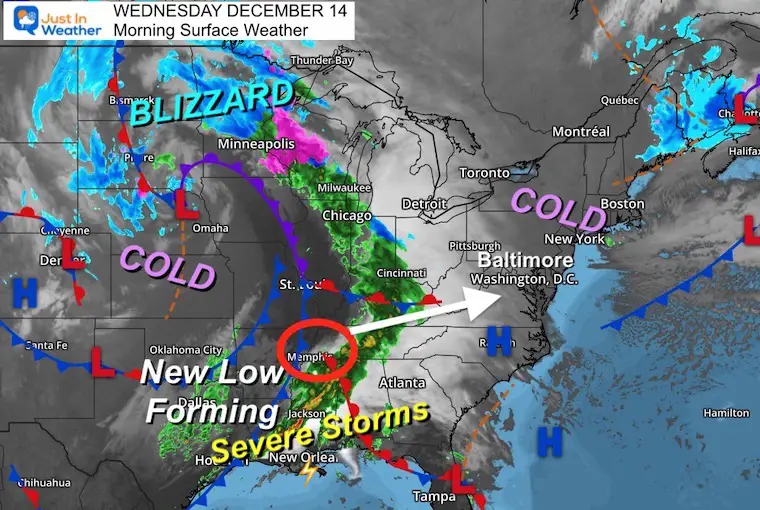
The Large Winter Storm has produced Blizzard Conditions in the Northern Plains, and severe storms with tornadoes in the South.
This Low is reforming in the South and will head our way.
We begin with a cold start, and then will take the Low Pressure to push in warmer air.
These are below average and will feel colder with increasing clouds.
Normal Low in Baltimore: 30ºF
Record 11ºF in 1960
SNOW: 4.2” 1951
Normal High in Baltimore: 48ºF
Record 71ºF 2015
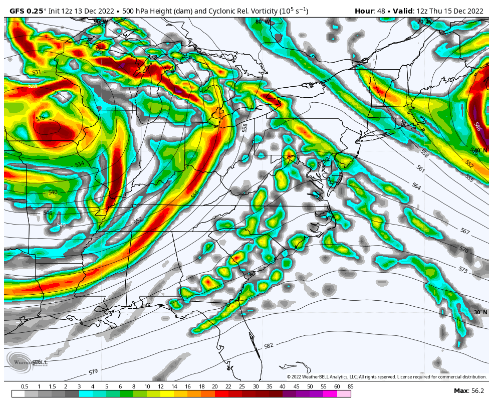
Model Comparison: GFS- Canadian- European
All still on target with arrival of sleet and freeing rain for most of our region between 3 AM and 6 AM, but as soon as midnight in the mountains. Places that get ice, will likely deal with it through the morning commute. The day sun angle and salting will help more after 10 AM.
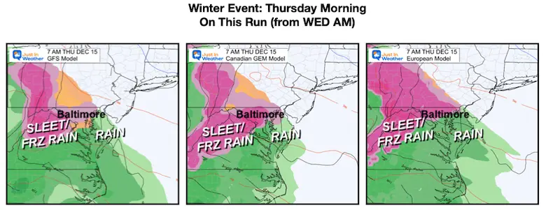
This is the split. GFS brings in snow to central MD, but temps should not allow much to stick (if this verifies).
I am partial to the Canadian Model which is trying to push that ice line to PA sooner.

The track of the Low will push in warmer air and just heavy rain to southern PA. Central PA may continue to get heavy snow in the mountains.
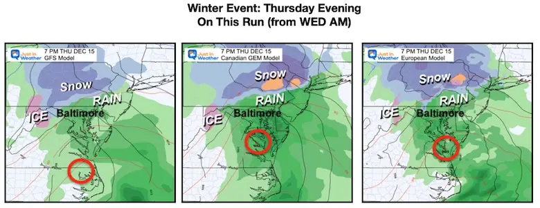
Canadian GEM Model THU 4 AM to FRI 1 PM
I am still going with this model solution showing moderate icing in the morning, then rain by evening…This should cut off with showers ending for us Friday morning.
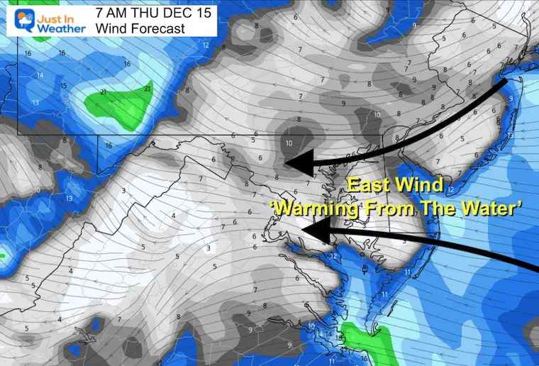
An east wind will bring in warmer air FROM the water. This is why more rain is expected, especially near the Bay and Delmarva.
This warmer air aloft is what will melt the falling snow, but surface cold will allow for icing farther inland.
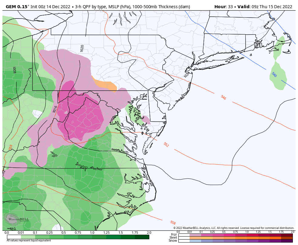
That freezing line is subject to change. I am working off the Model and climatology showing I-95 as the likely area to highlight with more icing west and north – INLAND! Some brief icing possible at the start within 5 to 10 miles of this line.
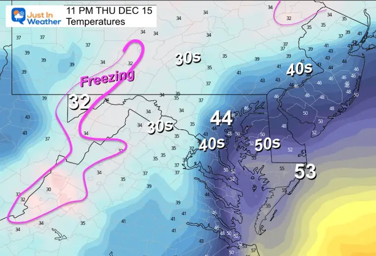
The freezing line will retreat west and north.
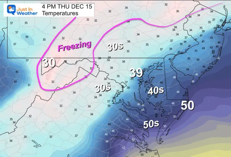
The freezing areas will be limited to the high mountains in the ice storm zone.
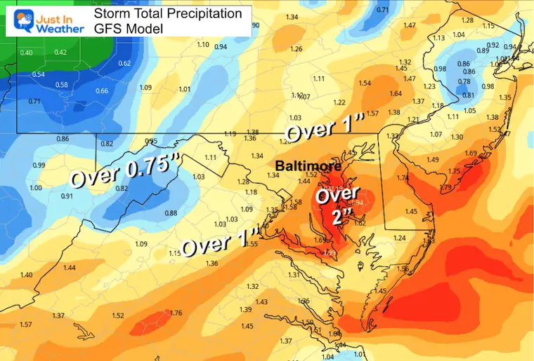
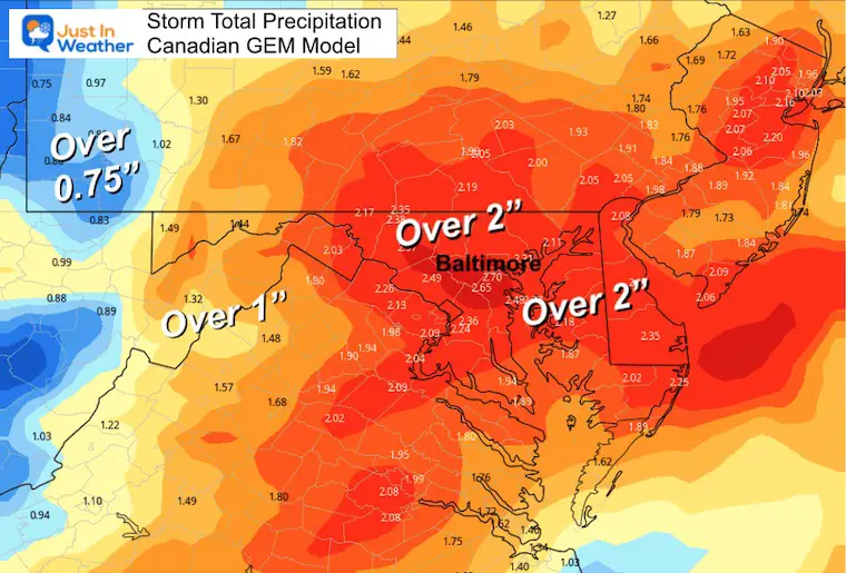
It may seem like quite a bit with the Canadian possibly overdoing the Over 2 inch swath. But I would be content to say over 1 inch is still an impressive storm total for the general area. Note, southern PA is actually in a rain deficit for the year.
A large area over 1 inch, with the 2 inch bullseye over Kent Island/Chesapeake Bay.
This has a much larger 2 inch total through southern Pennsylvania and much of Maryland. This may be a little on the high side.
My next report this afternoon will include expected icing and a deeper look into next week.
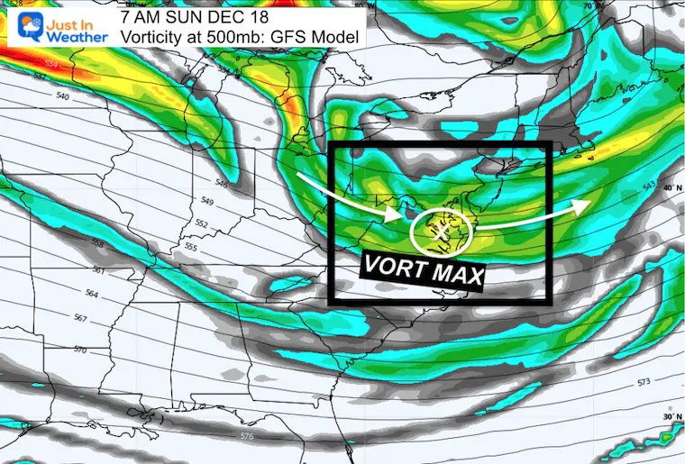
Here is the Vorticity/Spin at 500mb (around 18,000 Ft). This shows the energy aloft with two impulses over the weekend.
This is a broader base wave in a jet streak. It will keep clouds around, and may spit flurries or snow showers.
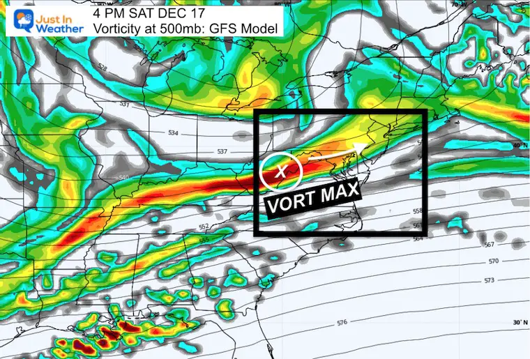
This is a weak Vort Max that may ignite some spotty showers with cold enough air to produce flakes without much substance. Just ambiance.
Faith in the Flakes.
Temps remain below average and the mother load of cold air may make a move just after this period and ahead of Christmas. With that I see two more attempts for snow or mix before Christmas, so it will remain active.
Snow Maps From National Weather Service Explained And Regional Links
December 5th Snow In Baltimore And The Start Of Faith In The Flakes FITF


Click to see more and ‘Book’ a visit to your school

I see many factors to support colder influence with multiple systems. Early and later in winter. Check it out.
Winter Outlook 2023 For Snow Not Typical La Niña Plus Polar Vortex Disruption
Atmospheric Memory Suggests Active Winter Storm Pattern Outlook
Winter Outlook 2023 From NOAA Very Different Than Farmers Almanacs
Winter Outlook 2023 Early Look At Snow From Two Farmers Almanacs
If you want a snowy winter, this is what you might want to look for in the rest of the tropical season. (You might be seeing a lot of commercial snow removal people out this Winter).
Record August For No Named Tropical Storms: Closer Look At Snow Following
Winter Weather Folklore Top 20 And More Outlook Signals From Nature For Cold And Snow
