


May 1 Weather Gradual Cooling Trend Will Bring Rain Into The Weekend
Wednesday, May 1 Morning Report One of the marks of May Day is an ancient European holiday celebrating the start of summer. It feels like we have had our taste…
Severe Thunderstorm Warning Issued: Wednesday Afternoon Wind Update
November 30, 2022
Early this afternoon the line of storms we have been expecting promoted a Severe Thunderstorm Warning by The National Weather Service. This was issued at 1:15 PM and included Hagerstown, Martinsburg, and Winchester until 2 PM. This is a sign of the strong wind gusts we have been discussing. While there may be some hail, pockets of winds gusting to 58 mph are possible in this cell/line.
Severe Thunderstorm Warning/Doppler Radar
If there are more warnings issued, I will add an update below.
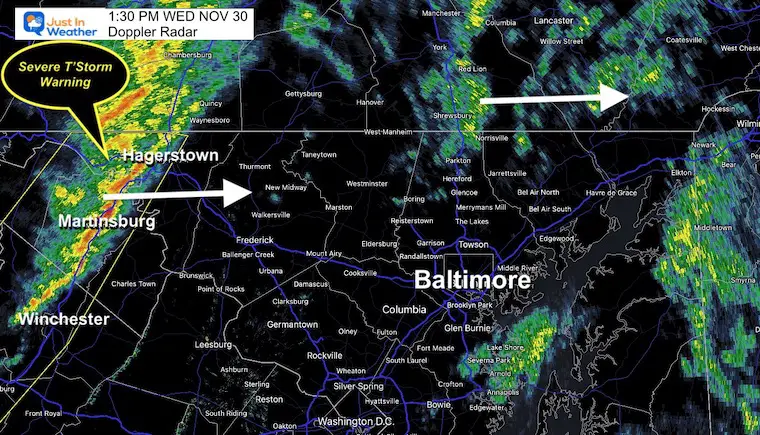
This appears to be moving faster
NO WARNINGS Have Been Extended, but the squall line may still push winds from 40 to 50 mph.
Frederick and Gettysburg get this by 2:30 PM. York and Westminster may get it closer to 3 PM.

We need to consider tracking this through our metro areas for the next few hours.
The final push with this weather system may be the strongest one. So far most of the region has had wind gusts in the 20 mph range. Baltimore’s BWI has observed up to a 25 mph wind gust this morning. The next wave may be stronger.
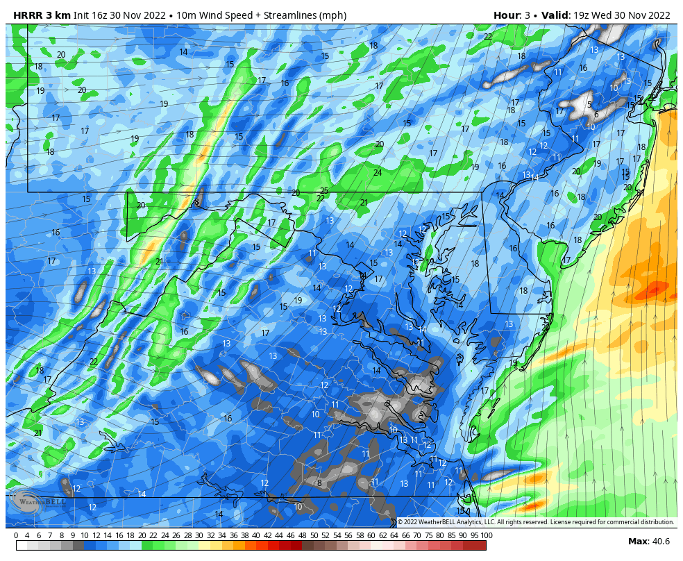
The line of rain will signal the shift of the winds and colder air mass moving in. This is when we could see a brief period of winds up in the 40 mph to 50 mph range. Here is a quick look at the timing.

The cold air will arrive within a few hours of this line of storms.

Use the controls to interact by panning or zooming in.
HRRR Model Forecast —> slider
2 PM to 7 PM
*These plots are suggestions. Consider up to one hour earlier for the cities I added to the map.


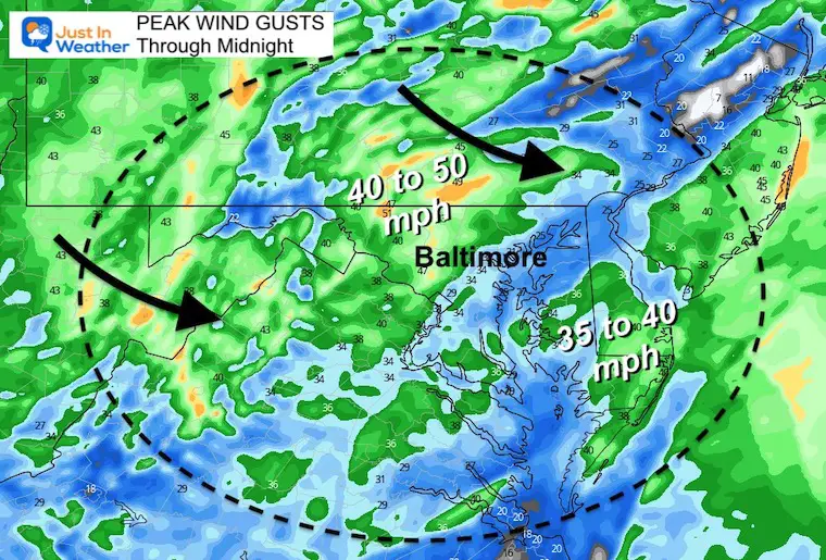
Wind will peak with the line, then ease a bit this evening. It will remain breezy and noticeable with the colder air tonight. But not as strong.
Top winds between 40 and 50 mph.
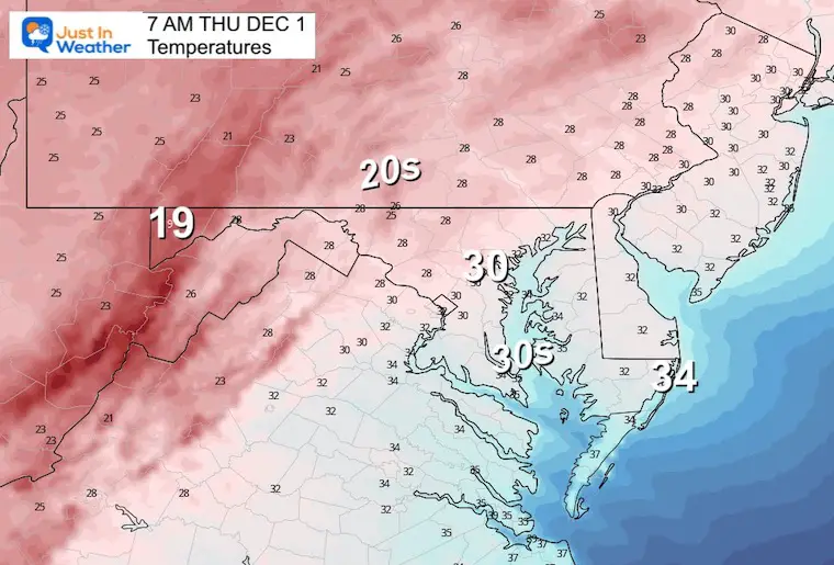
2 PM Wednesday to 7 AM Thursday
Temps drop below freezing for most by morning.
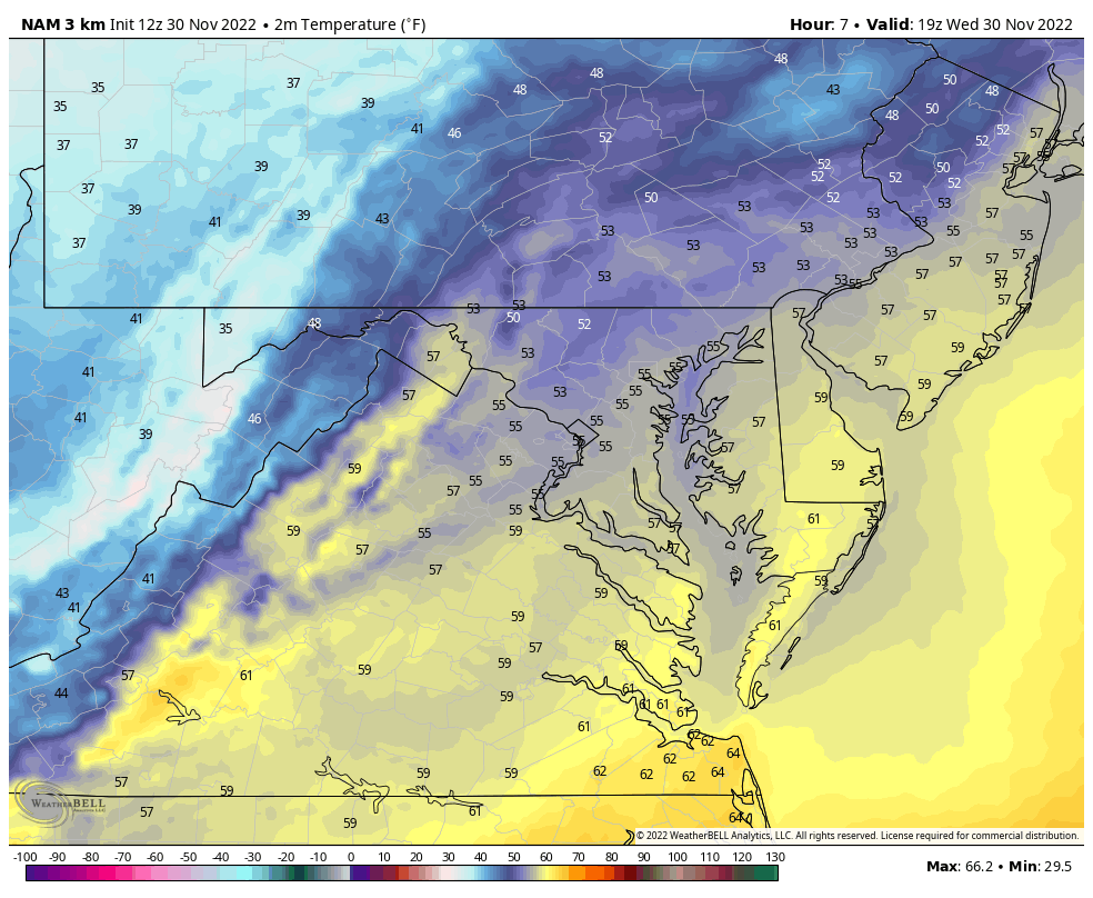
Baltimore to the western and northern suburbs will be between the mid 20s to near 30ºF.
Follow Up: I will have a report tonight on the updated December Outlook for cold and early start to winter.
I see many factors to support colder influence with multiple systems. Early and later in winter. Check it out.
Winter Outlook 2023 For Snow Not Typical La Niña Plus Polar Vortex Disruption
Atmospheric Memory Suggests Active Winter Storm Pattern Outlook
Winter Outlook 2023 From NOAA Very Different Than Farmers Almanacs
Winter Outlook 2023 Early Look At Snow From Two Farmers Almanacs
If you want a snowy winter, this is what you might want to look for in the rest of the tropical season. (You might be seeing a lot of commercial snow removal people out this Winter).
Record August For No Named Tropical Storms: Closer Look At Snow Following
Winter Weather Folklore Top 20 And More Outlook Signals From Nature For Cold And Snow


Click to see more and ‘Book’ a visit to your school
