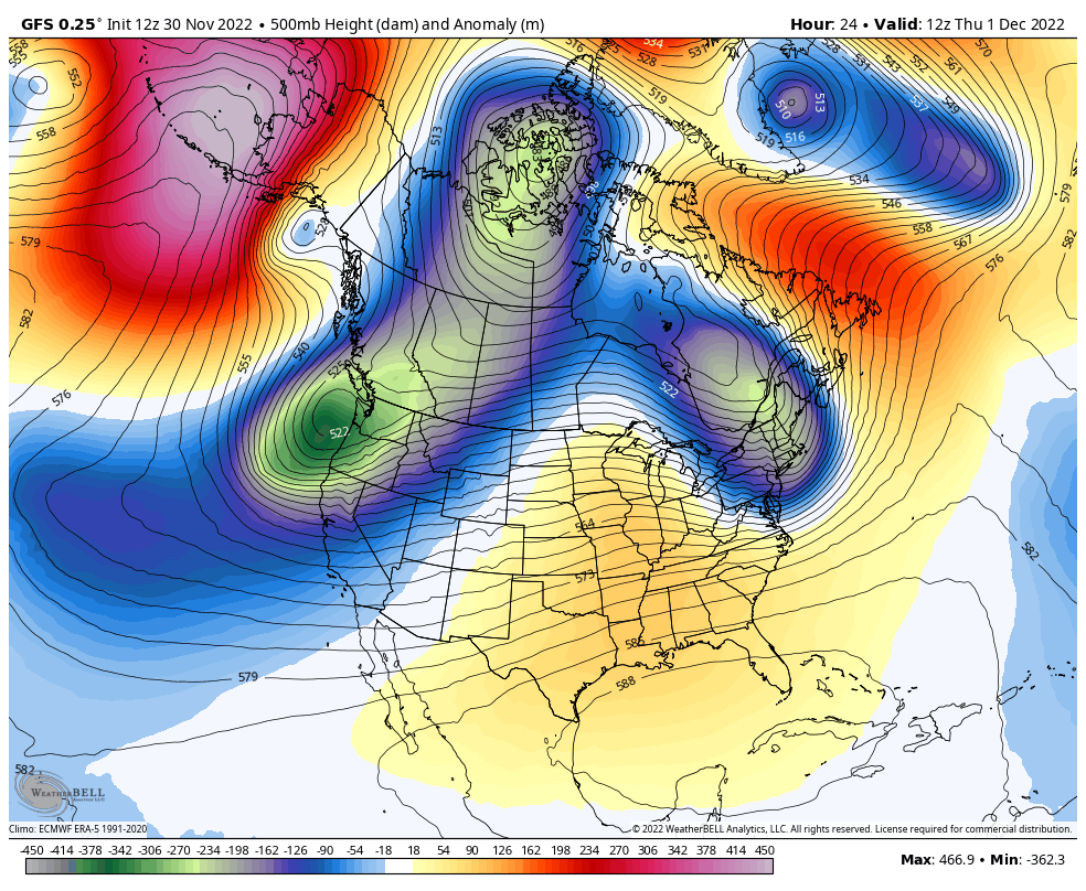
December 1 marks the beginning of meteorological winter and it is looking colder than average. While we start chilly, there will be another mild push for a few days before the real change sets in. Besides the popular Polar Vortex, the North Atlantic Oscillation may be the main player and it is showing up in the NOAA Outlook.
Let’s start with the change of season. We group seasons in a set of 3 complete months, so our records for this season will continue through the end of February. This is contrary to the astronomical winter that is marked on most calendars on the day of the winter solstice. This year that is on December 21. If you really want to get out, the sun will point in the Tropical of Capricorn exactly at 4:47 PM EST. This also marks the shortest daylight of the year for us in the Northern Hemisphere.
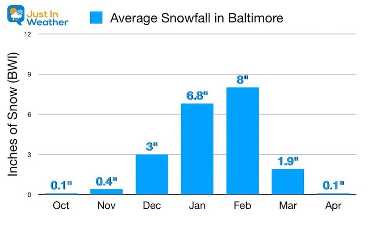
Start Of Reasonable Snowfall
I believe it is now safe to discuss cold and snow. Please note that for simplicity I am using some data from Baltimore as my home region and central to the Mid Atlantic. Let’s take a look at snow data a BWI.
Long Term Average Season
While we can get a rare snow event in Autumn, December is when we typically get measurable snow at the airport and metro areas. Notice how an average winter will increase the monthly snowfall in January and maxes out in February.
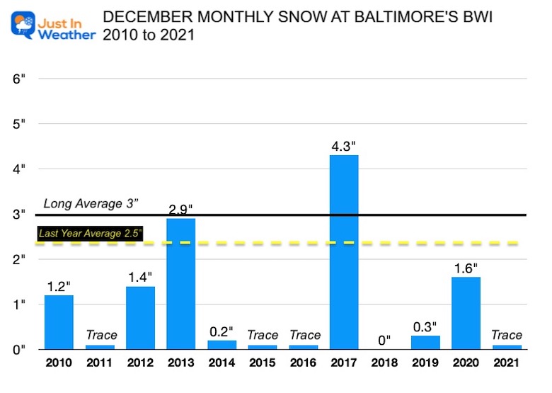
December: Monthly Snowfall Since 2010
Since the start of the last decade:
- 11 of the last 12 years there has been at least a trace of snowfall.
- 5 years had over 1 inch of snow, about 42% of the time.
- Only 1 year had nothing!
NOTE: 2009, the year before this chart, we had a record snowstorm that helped boost the monthly total to 20.1 inches. That winter ALSO gave us the two blizzards in a 5-day span in February. It was wonderful! #FITF
*The longer term average was 3″ snow total for the month. The latest 30 year cluster dropped to 2.5″. It’s important to note the colder inland suburbs just 20 miles away can get close to double this amount.
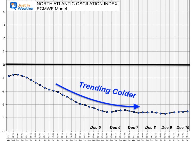
If you read my prior report on the colder December and Winter Outlook, this is an update to show the pattern evolving. If you scan other resources, you may hear about the Polar Vortex, but I believe main player this month will be the North Atlantic Oscillation. This index, when negative (-NAO), will tend to bring colder temperatures to the Eastern US.
ECMWF Forecast
The latest European Model shows the Index dropping and holding steady between -3 and -4 from December 5 to 10. Then we may be off to the races…
-NAO
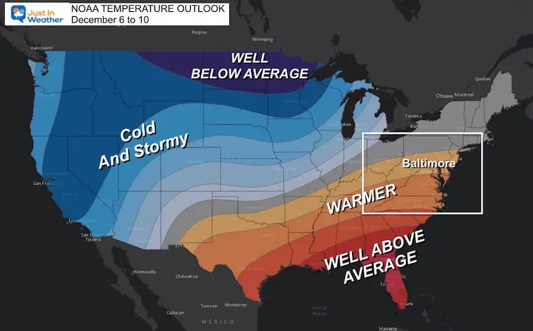
NOAA OUTLOOKS
As I noted in my Winter Outlook and recent update, the cold air may take a week to 10 days to evolve, but we will get there. You may have heard this in recent years, however there is a lot of support this time!
Short Term:
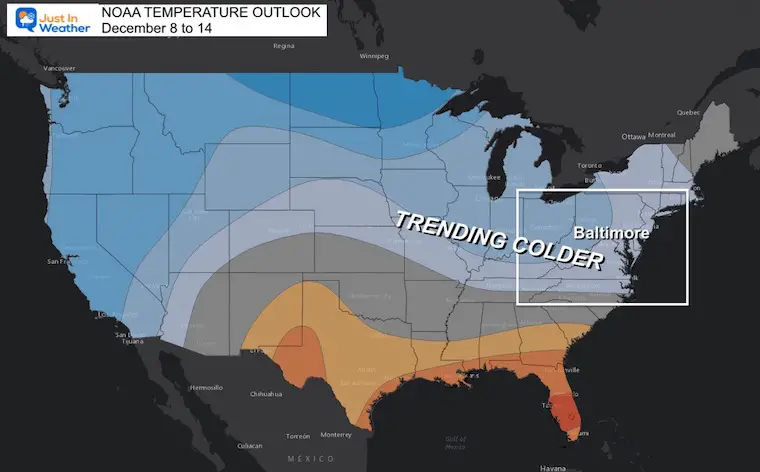
Temperatures Days 6 to 10
Cold North and West, Warmer Mid Atlantic and Southeast US
A Ridge will bring us milder air over the next week, but it will not last.
Well Below Average air will establish across the Northern Plains. Even cold for them! Plus the Rockies will be cold and snowy.
Precipitation
The storm track we have been seeing will continue from Texas, up the Ohio Valley, and to the northeast. This is what will keep us on the mild side.
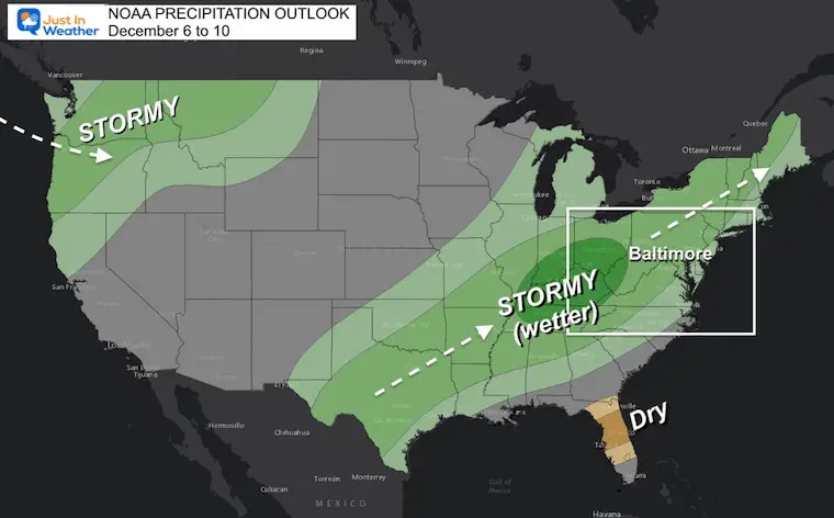
Longer Look Ahead: Days 8 to 14
This is the mark of the change. That colder pattern will expand east as we trend colder. This is the ‘average’ over period. What it does not show is that it will be getting much colder towards the later time frame.
Jet Stream Set Up
I know this more than a week out, but the long wave pattern is pretty reliable. The surface weather (synoptic storms) are much less reliable beyond 5 to 7 days. That is why I DO NOT usually mention any suggestion more than one week ahead of time.
I do not have a storm to show you now. However, one hint of a storm may be a shortwave we entering southern California and tracking the the east coast.
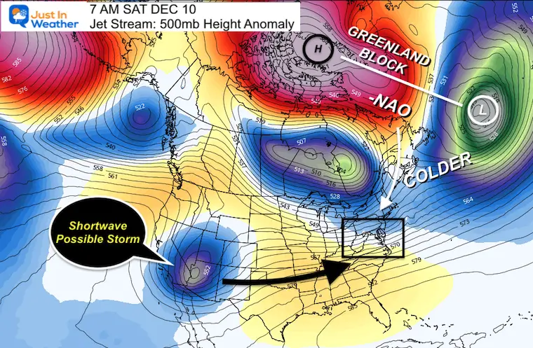
December 10
Here we see the Greenland Block that will force the very strong -NAO will be our source of colder air.
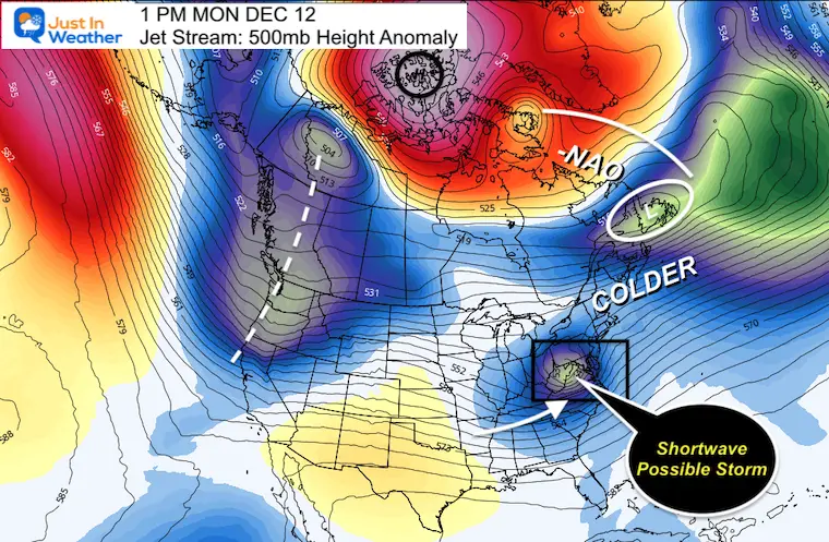
December 12
Here we see the very strong -NAO holding firm, PLUS there may be a shortwave near the Mid Atlantic.
Jet Stream Animation
Dec 1 to Dec 12 – Watch this circulation develop to match the plots I showed above.
Note: It is likely that a storm is NOT EXACTLY as shown here. This is a suggestion that the pattern will really try to produce one (or a few) for us after December 10.
Also:
Very often you may read about a storm more than 1 week away on some other sites, but they don’t work out. For that same flaw in the modeling, I like to think the ingredients will show, but the synoptic plots may not show the real event until we are within one week and they actually line up BETTER.
Faith in the Flakes my friends. It is about to get fun!
I am not alone:
Dr. Judah Cohen has been amping up his expectation and wrote a very lengthy article about this. He draws some analog connections to other impressively cold Decembers such as 1995 and 2009 related to similar -NAO and even La Niña Conditions. Both of those brought us plenty of cold and snow.
Faith in the Flakes Gear
SEE THE NEW ITEMS THIS YEAR

NEW REPORTS:
Record Snow Cover Across The Northern Hemisphere
Snow Cover Now At 56 Year High In The Northern Hemisphere
December Pattern Change
How The Winter Weather Pattern May Develop In Early December
My Winter Outlook: Not A Typical La Niña!
I see many factors to support colder influence with multiple systems. Early and later in winter. Check it out.
Winter Outlook 2023 For Snow Not Typical La Niña Plus Polar Vortex Disruption
Also See The Winter Outlook Series:
Atmospheric Memory Suggests Active Winter Storm Pattern Outlook
Winter Outlook 2023 From NOAA Very Different Than Farmers Almanacs
Farmer’s Almanac Comparison
Winter Outlook 2023 Early Look At Snow From Two Farmers Almanacs
Triple Dip La Niña Winter
Winter Outlook 2023 La Niña Triple Dip Expectations
CONNECTION TO WINTER?
If you want a snowy winter, this is what you might want to look for in the rest of the tropical season. (You might be seeing a lot of commercial snow removal people out this Winter).
Record August For No Named Tropical Storms: Closer Look At Snow Following
Wooly Bear Caterpillars
Winter Weather Outlook From The Wooly Bear Caterpillar
Persimmon Seeds
Winter Weather Outlook: Persimmon Seeds And Snow Folklore
Click to see Top 20 and MORE
Winter Weather Folklore Top 20 And More Outlook Signals From Nature For Cold And Snow
SNOWSTIX – Available Now

Normals And Records: Maryland and Baltimore Climate History

STEM Assemblies/In School Fields Trips Are Back
Click to see more and ‘Book’ a visit to your school

Please share your thoughts, best weather pics/videos, or just keep in touch via social media


