Ian A Tropical Storm Thursday Morning: New Landfall Videos And Forecast Over Atlantic
Thursday Morning September 29 2022
Hurricane Ian made landfall Wednesday with 155 mph winds and it is still crossing Florida this morning with winds down to 65 mph. Over 2.5 million customers are without power and parts of the electrical grid will need to be completely rebuilt. It has taken all night to break it down to a tropical storm, but it is about to reemerge over water this morning. A little faster than earlier models suggested.
Feet of flooding has been widespread, and there is some video to show that below.
Ian should remain a tropical storm, however it will pick up more moisture and dump more rain after a second landfall in South Carolina through Maryland this weekend. I would not discount a brief intensification back to Category 1 hurricane over the next 24 hours.
In addition to this update and new forecast maps, I wanted to share a few videos from landfall. They show the incredible power and destruction but also what NOT to do!
Landfall Video On Fort Myers
Get your audio ready as you will hear the sound of the fury!
The Sound and the Fury!
Turbine Jet Edition.
SOUND UP! 😬
🌬💨💨💨🍃🍃🍃🍃🌊🏄♂️🌊🏄♀️#hurricaneian 🌀 #Ian #Hurricane #Florida #FortMeyers #StormSurge #HurricaneIan #naplesflorida #naples pic.twitter.com/AiPpQv78xx— GRG | Sentinel 🇺🇸 (@GRGSentinel) September 29, 2022
Ian: Sep 29 Thursday Morning
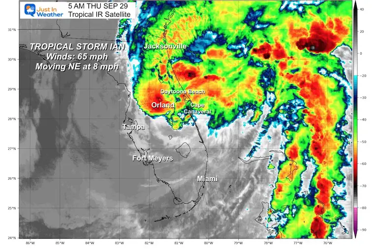
Quick Stats at 5 AM
- Winds are 65 mph
- Moving to the NE 8 mph
- Located 40 miles SE of Orlando, 35 miles SW of Cape Canaveral
- HUGE SIZE
- Tropical Storm force winds extend 415 miles from the center.
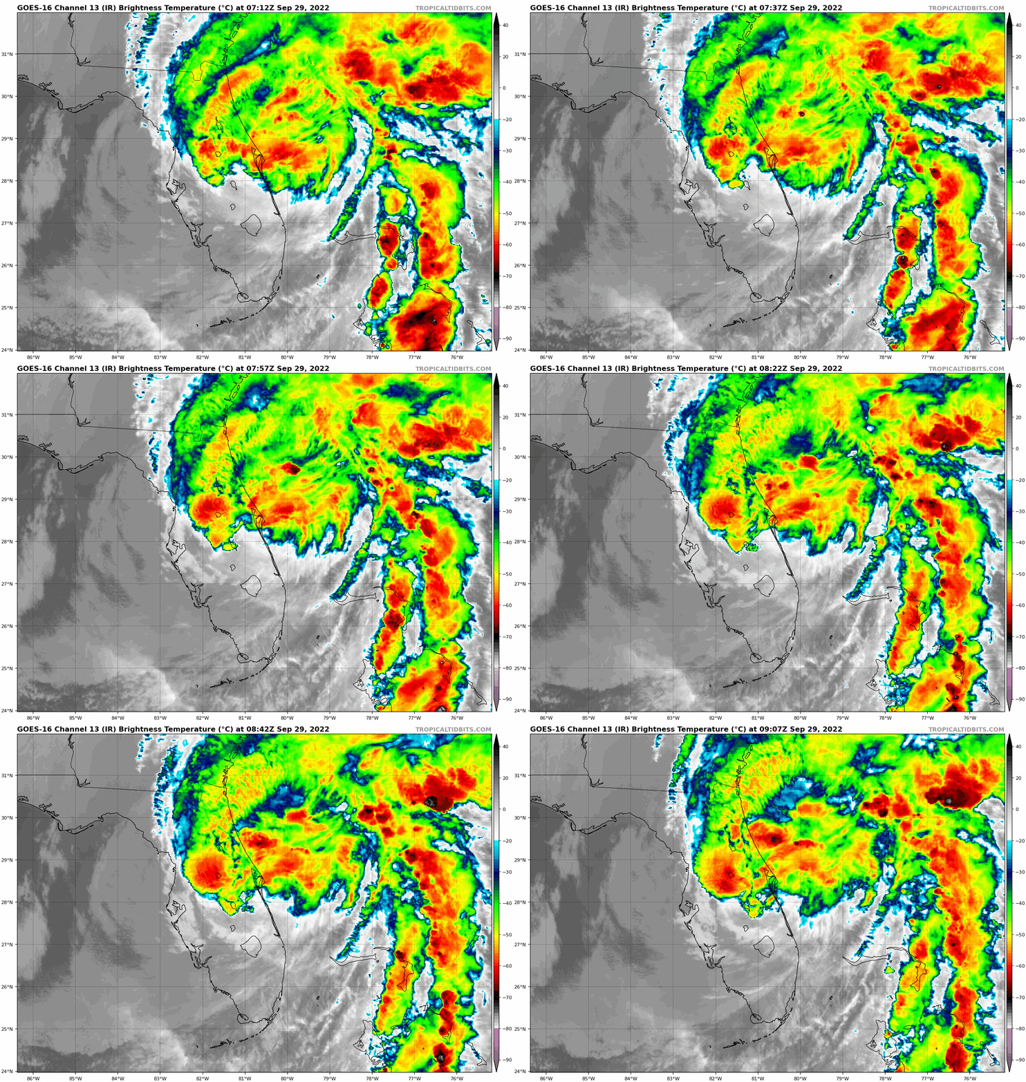
IR Satellite Loop
Top 5 Landfalling Storms With Winds 155 mph or Higher Include:
- 185 mph in 1935 – Labor Day Day (unnamed)
- 175 mph in 1969 – Camile
- 165 mph in 1992 – Andrew
- 160 mph in 2018 – Michael
- 155 mph in 2023 – Ian
Storm Name History/Retirement
Since 1954, 94 storms have had their names retired.
I named storms are 13 of them.
Since 2000, 44 storm names were retired.
Of them, 11 began with the letter I. This is going to be number 12.
Videos
In the age of social media, we get quick looks at the storm impact but also people doing things I do not recommend because they are dangerous. Please check this out and share.
Storm Surge:
Look at all the debris floating in the water.
BREAKING: #StormSurge From #Hurricane #Ian In #FortMeyers #Florida Area Is Devestating! pic.twitter.com/vv2plGP942
— John Basham 🇺🇲 (@JohnBasham) September 28, 2022
WHAT NOT TO DO:
This guy was swimming in the flooded water in his home. There is so much debris, fuel, and perhaps bacteria in that water it is truly not a wise idea to submerge yourself in it.
What NOT to do when you get #flooding indoors.
That water isn’t safe/healthy!#HurricaneIan https://t.co/m5i1t7PJse— Justin Berk (@JustinWeather) September 28, 2022
TV COVERAGE
This is the famous Jim Cantore. I know him and he has always been nice to me. However, there was no need to be out in the middle of this street on TV. He almost got killed and realized it was a mistake. Yes, at some point some one is going to get hurt!
At some point, someone is going to get seriously hurt (or worse) trying to increase viewers on TV.
I covered storms Live on TV for 20 years and knew the limit for safety.
Veterans please set a better example. https://t.co/BlkJYrKyhE— Justin Berk (@JustinWeather) September 28, 2022
Power Outages as of 5 AM Thursday Sep 29
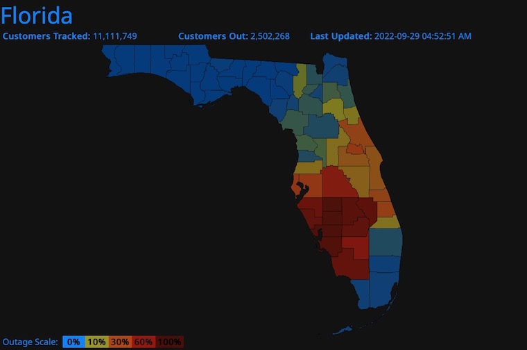
See the live update from https://poweroutage.us/area/state/florida
LIVE RADAR WIDGET
Also See: Landfall Radar and Videos
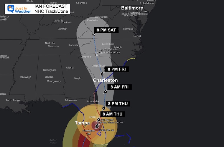
Forecast Track
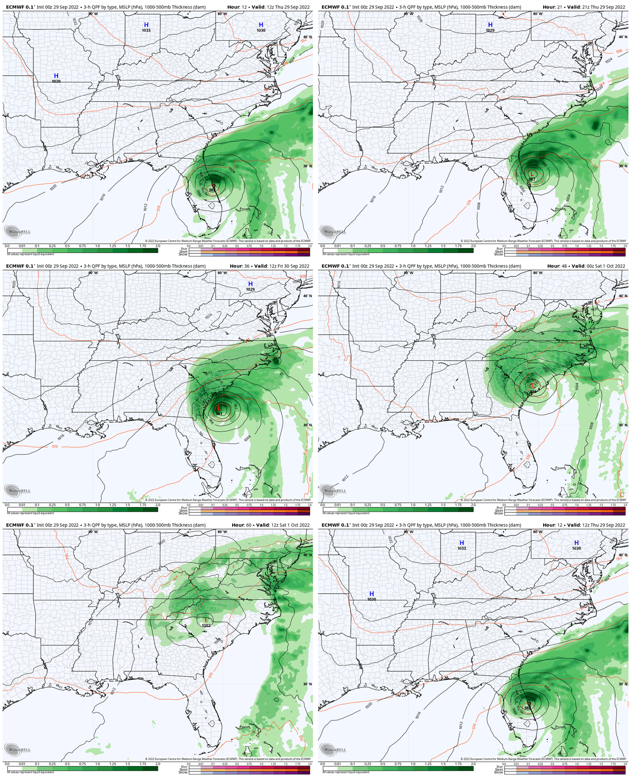
Ian will move back over the water of the Atlantic this morning, then curve into the coast of South Carolina…
Additional flooding rain and storm surge to places like the St. Johns River in Jacksonville.
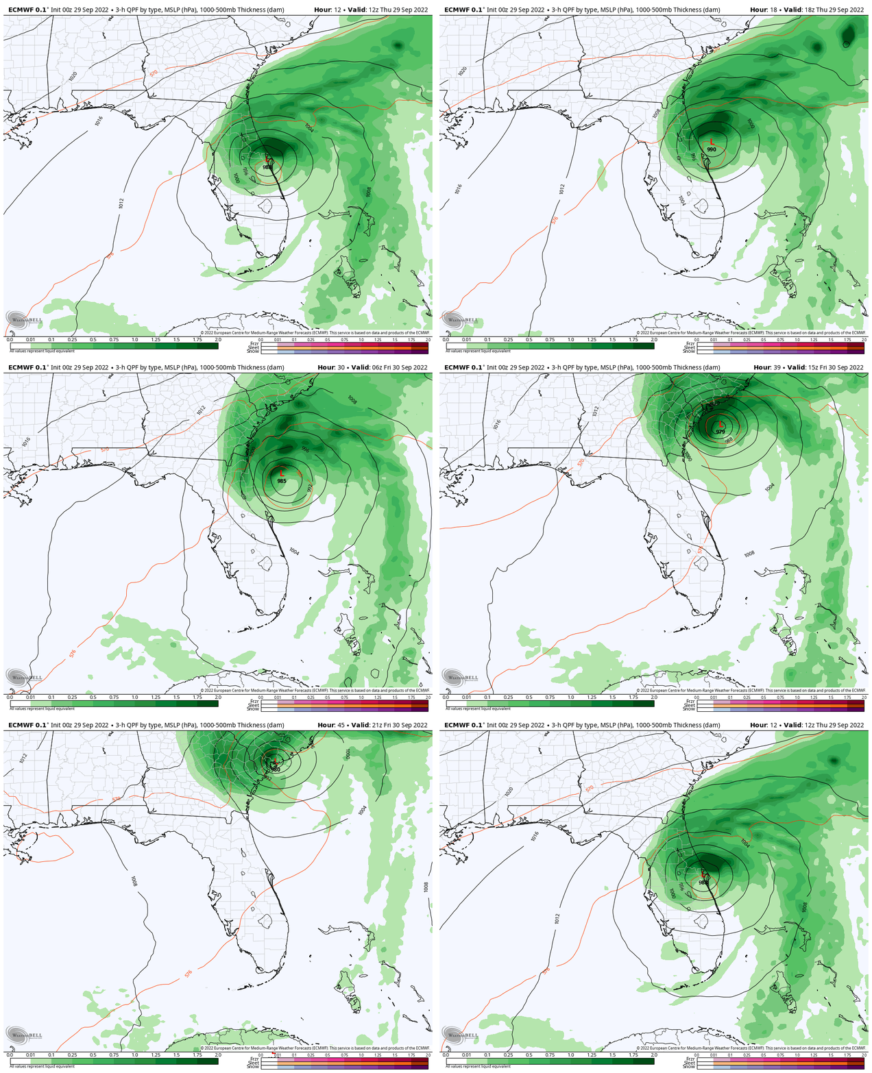
ECMWF Model Simulation
8 AM Thu to 5 PM Friday
The east wind will push water onshore and more Surge expected on the coast. The St. Johns River in Jacksonville is most vulnerable and will be the headline today.
NEW Watches and Warnings
A Storm Surge Warning is in effect for…
* Middle of Longboat Key southward to Flamingo including Charlotte Harbor
* Flagler/Volusia Line to the mouth of the South Santee River
* St. Johns River
A Tropical Storm Warning is in effect for…
* North of Bonita Beach to Indian Pass Florida
* Boca Raton Florida to Cape Lookout North Carolina
* Lake Okeechobee
A Storm Surge Watch is in effect for…
* North of South Santee River to Little River Inlet
A Hurricane Watch is in effect for…
* Flagler/Volusia County Line to the South Santee River
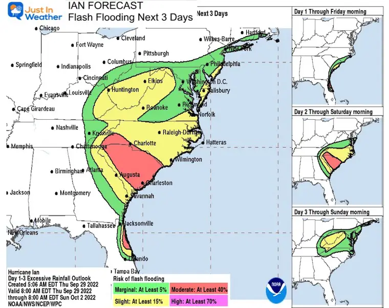
Flash Flood Risk
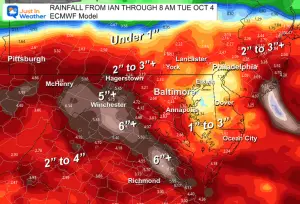
Heavy rain will expand north through the weekend. There is a small chance for flooding into the Mid Atlantic and Northeast.
Forecast Simulation: Wider View
ECMWF Model 8 AM Thursday to 8 AM Saturday
Rain will reach Maryland and The Mid Atlantic Friday night. Saturday will be soggy and could last into Sunday. I will have more on our local forecast in my next report.
Look At My Rain Report Last Night
Weather posts straight to your inbox
Sign up and be the first to know!
PATTERN CHANGER?
CONNECTION TO WINTER?
If you want a snowy winter, this is what you might want to look for in the rest of the tropical season.
Rainbow Ice Cave In Mt. Rainier A Very Rare Find: Photos And Video
Weather posts straight to your inbox
Sign up and be the first to know!
Hurricane Season Forecast: June 1 Through November 30
NOAA 2022 Hurricane Forecast- Above Normal Again
Related Posts
NOAA Study: Reducing Air Pollution INCREASED Tropical Storms
Atlantic Tropical History: Maps of Origin Regions Every 10 Days
Please share your thoughts, best weather pics/videos, or just keep in touch via social media
-
Facebook: Justin Berk, Meteorologist
-
Twitter: @JustinWeather
-
Instagram: justinweather
STEM Assemblies/In School Fields Trips Are Back
Click to see more and ‘Book’ a visit to your school


