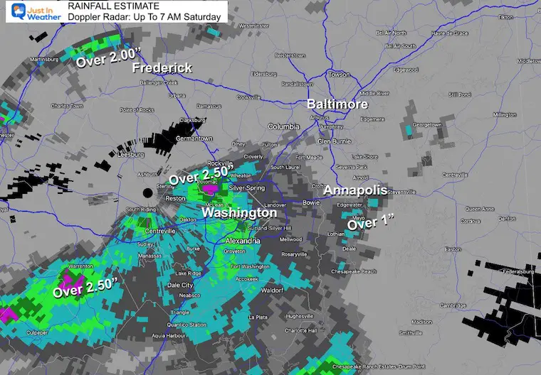
Yesterday I posted about the potential flooding followed by the official Flood Watch AND Excessive Rainfall Moderate Risk.It appears that the slight adjustment today will be the focus of that heavy rain for southern Maryland to the beaches. A Flood Watch remains in place for central Maryland with numerous Warnings already issued for rainfall from 1 to over 2.5 inches falling so far.
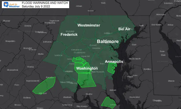
Flood Warnings and Watch
Flood Warnings (light green) have been issued across metro Washington and Annapolis where anywhere from 1 to over 2.5 inches of rain have fallen already.
A Flood Watch remains in place for Central Maryland until further notice.
Radar Recap: 3:30 AM to 7 AM
Heavy rain has fallen before sunrise..
Rainfall Totals (so far)
The heaviest rain has been around Washington DC
Yes, rain will linger today and may last in metro areas until mid afternoon, however a good chance for an improvement in metro Baltimore and north for any plans later today and this evening.
Southern Maryland and the beaches will remain wet longer, but we all should see the improvement on Sunday.
Morning Surface Weather
Low Pressure has already produced the early rainfall, with another piece of energy expected to move east along the stalled front.
The focus has shifted a little farther south.
Radar Simulation: 8 AM to Midnight
Timeline Slider—->12 PM to 10 PM
While I believe this produce is 1 to 2 hours slow, the focus of the rain shifting south is the main story. It will improve and possibly clear out north of Baltimore into Southern PA, while rain continues all day in Southern Maryland to Ocean City.
july-9-weather-rain-radar-forecast-saturday-pm-12
july-9-weather-rain-radar-forecast-saturday-pm-1
july-9-weather-rain-radar-forecast-saturday-pm-2
july-9-weather-rain-radar-forecast-saturday-pm-3
july-9-weather-rain-radar-forecast-saturday-pm-4
july-9-weather-rain-radar-forecast-saturday-pm-5
july-9-weather-rain-radar-forecast-saturday-pm-6
july-9-weather-rain-radar-forecast-saturday-pm-7
july-9-weather-rain-radar-forecast-saturday-pm-8
july-9-weather-rain-radar-forecast-saturday-pm-9
july-9-weather-rain-radar-forecast-saturday-pm-10
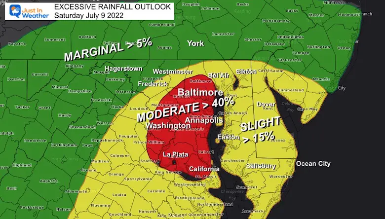
NWS: Excessive Rainfall Outlook
This is the map I showed last night. It appears the focus for the heaviest rain has shifted south a bit. I also want to emphasize that an image like this looks like a bullseye, but shows the 40% chance for flooding. That is a Moderate Risk, but not a promise.
Save This Severe Weather Page:
Click the link or see it on the Home Page to see ALL Local Alert (Watches and Warnings) will be posted on this page. You can click on each weather element for the details as flooding and even some severe storms may be tracked.
Live Radar And Lightning Widget
Compare to the simulation forecast animations below
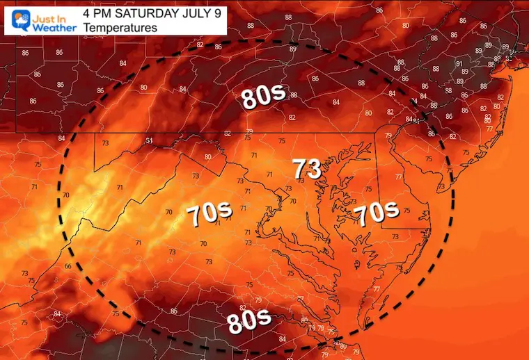
Afternoon Temperatures
Here we can see the impact of the clouds and rain, holding temps in the 70s.Where the sun breaks out, temps in southern PA will rebound to the 80s.
CLIMATE DATA
TODAY July 9th
Normal Low in Baltimore:67ºF
Record 54ºF in 1984
Normal High in Baltimore: 88ºF
Record 103ºF 1936
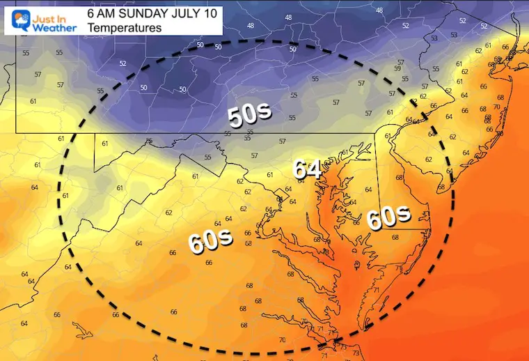
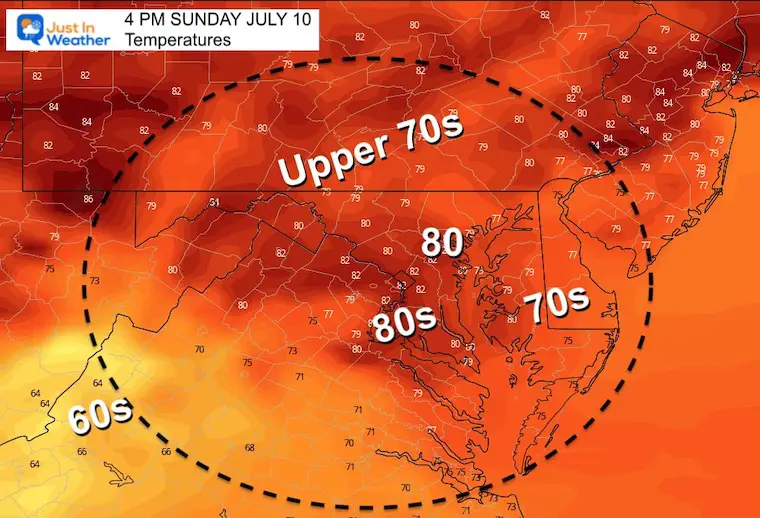
SundayTemperatures
Morning
Afternoon
Weather posts straight to your inbox
Sign up and be the first to know!
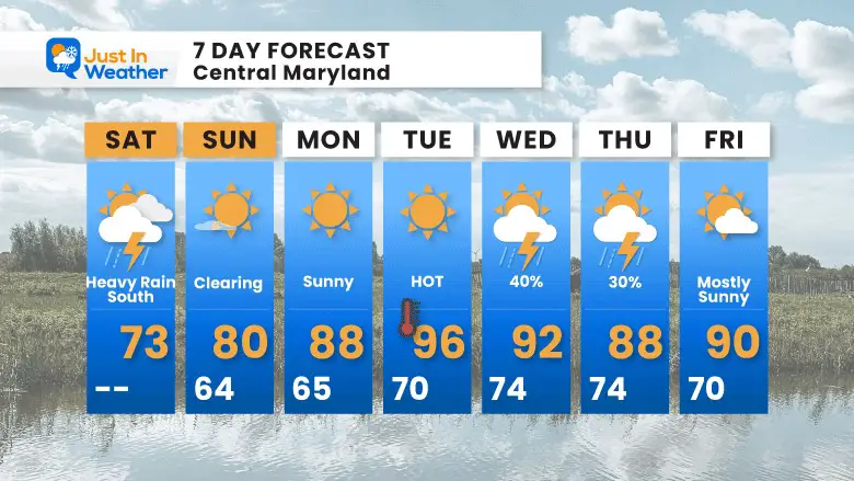
7 Day Forecast
Improving Sunday then a brief heat surge during the work week.
Plan Your Kayaking Day Now
Hurricane Season Forecast: June 1 Through November 30
I am aware there are some spelling and grammar typos. I have made a few public statements over the years, but if you are new here you may have missed it:
I have dyslexia, and found out at my second year at Cornell. I didn’t stop me from getting my meteorology degree, and being first to get the AMS CBM in the Baltimore/Washington region.
I do miss my mistakes in my own proofreading. The autocorrect spell check on my computer sometimes does an injustice to make it worse.
All of the maps and information are accurate. The ‘wordy’ stuff can get sticky.
There is no editor that can check my work when I need it and have it ready to send out in a newsworthy timeline.
I accept this and perhaps proves what you read is really from me…