


May 9 Cooler With Rain And Severe Storm Risk Tonight South
Thursday May 9 Morning Report Today is the first day of the year with sunrise before 6 AM in Baltimore, but we won’t see it. After a high temperature of…
Sunday April 24 2024
Today was a blip. Well, for some. Earlier I posted on social media that I was out golfing with my son and it was hot! There were many that were surprised, and then I recalled my morning forecast has a wide range of temps expected today. Before we get to the chilly outlook and next potential frost, check out the max temps today (Sunday). Remember, we had a mountain snowstorm earlier this week…
If you drove 2 hours or less from Baltimore, you could have been been either in summer or in the chill.
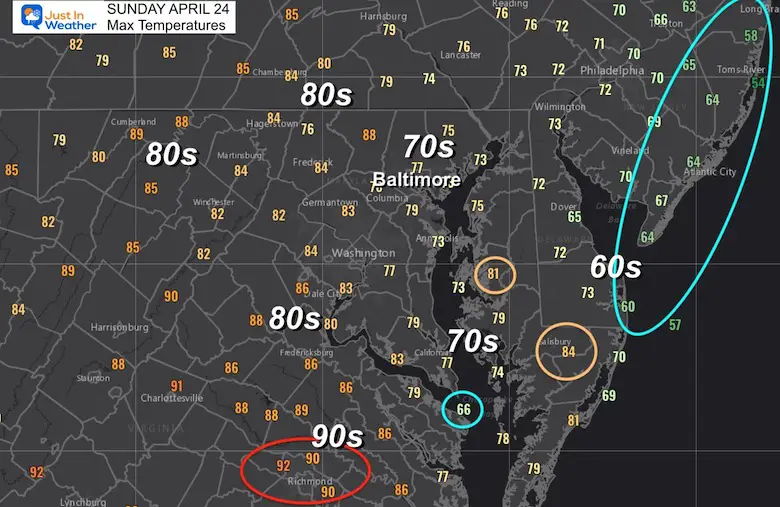
That stationary front shows up well to explain out local temperature phenomenon.
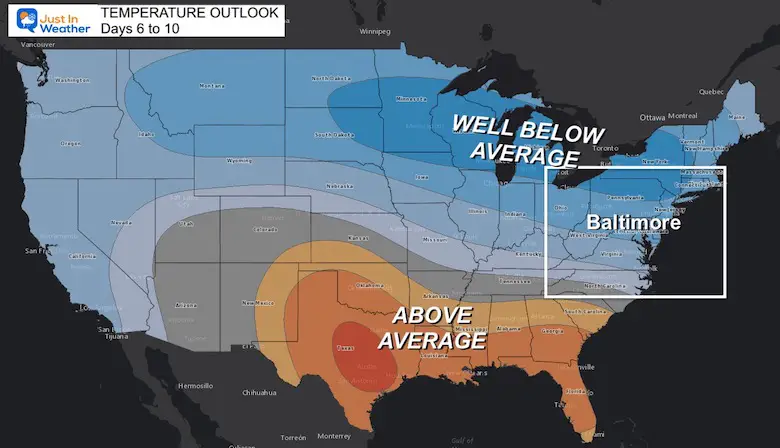
But our attention should be drawn to the Northern Plains. They had their second blizzard in a week, and we will not see any of that… But the residual cold air will be spilling our way this week, arriving Wednesday and Thursday.

This is the short range outlook showing well below average temps across the Great Lakes to the Mid Atlantic. In fact, much of the Nation should be cooler than average this week.
This is the extended outlook that takes us out 2 weeks, and shows the persistent reinforcement of chilly air. See the Jet Stream Animation below.
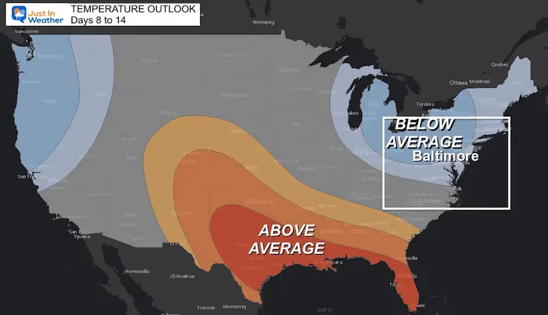
This is a long 2 week loop, but I put this together simply for the trend. It looks like we get Cut Off Low in Northern New England Wednesday into Thursday. That will help bring the cold wave in, with Thursday morning Frost very likely.
While the pattern does relax a little, we should remain slightly below average on temps, until another Deep Trough and possible Polar Vortex Disruption after the first week of May. Yes, they can happen out of winter and we really missed out on this in December…
By that point, Frost is more of a likelihood inland away from the water, but something to keep in mind for planting and that typical ‘after Mother’s Day’ folklore many follow.
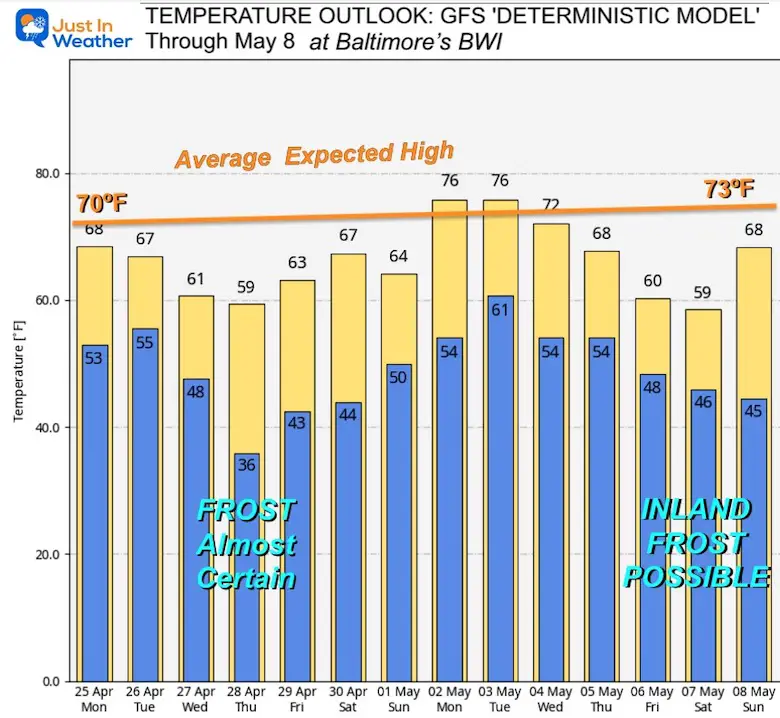
Note: This is for Baltimore at BWI. It will undoubtedly be cooler inland, away from the water… But warmer in the mornings by the Bay and Ocean.
This is just one plot, but the most reliable with temperatures in the ling range…
I’ve annotated the average High Temperature trend AND the possible morning Frost dates to look out for…
Some food for thought…. I will see you back on Monday morning with my full weather report.

Atlantic Tropical History: Maps of Origin Regions Every 10 Days


*Disclaimer due to frequent questions:
I am aware there are some spelling and grammar typos. I have made a few public statements over the years, but if you are new here you may have missed it:
I have dyslexia, and found out at my second year at Cornell. I didn’t stop me from getting my meteorology degree, and being first to get the AMS CBM in the Baltimore/Washington region.
I do miss my mistakes in my own proofreading. The autocorrect spell check on my computer sometimes does an injustice to make it worse.
All of the maps and information are accurate. The ‘wordy’ stuff can get sticky.
There is no editor that can check my work when I need it and have it ready to send out in a newsworthy timeline.
I accept this and perhaps proves what you read is really from me…
It’s part of my charm.