January 9 Recapping The Brief Snow Then Next Storm Brings Rain
January 9 2023
Monday Morning Report
Last night I asked the question if snow falls overnight and you sleep through it, then it melts, did it really happen? Well, it did happen, and I wanted to recap the radar simply for posterity. We spent a week talking about this weather system that was never expected to amount to much. However, there is now documentation online that shows the sporadic evolution of the modeling and the results.
Here is a brief review, followed by the regular weather report.
Headlines
- Overnight Snow Recap
- Today: Breezy and cool
- Thursday and Friday: Warmer with Rain
- Weekend: Cooler and maybe flurries to end
Overnight Snow
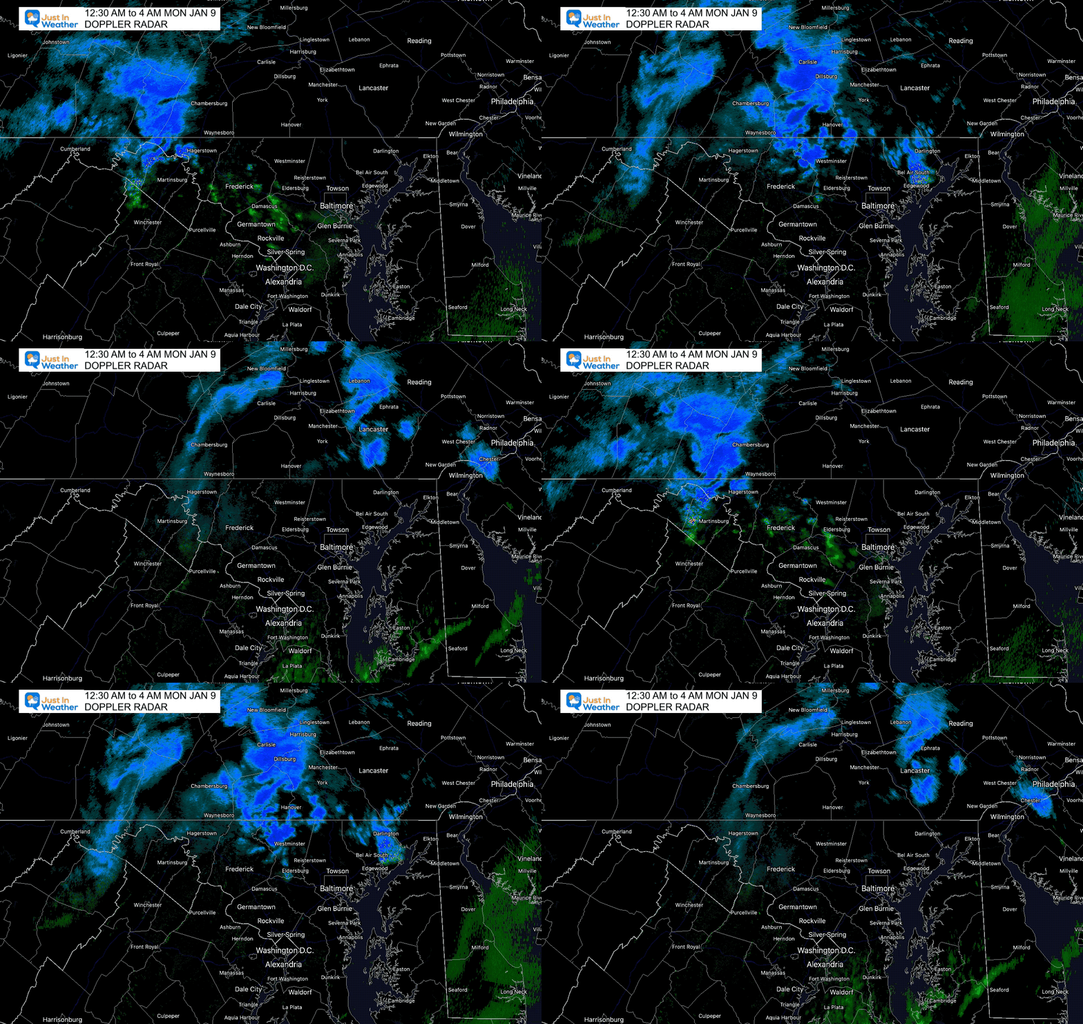
One week ago, this looked like two systems with a stronger one today. It ended up being a few hours in duration, but it did happen. As expected, temps remained above freezing, so roads remained wet. If there was any stickage, it would have been on the grass, decks, or car tops.
There was a coating of snow and traffic problems in Pennsylvania north of York around Harrisburg.
Doppler Radar Loop
12:30 AM to 4 AM
NightCam Of Snow In New Cumberland PA
@JustinWeather New Cumberland PA at 0430 pic.twitter.com/OcSIT9kCG7
— Michael Cadden (@MikeC2083) January 9, 2023
Snapshots: Who Got Snow?
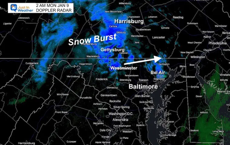
Westminster to Bel Air and north…
2 AM
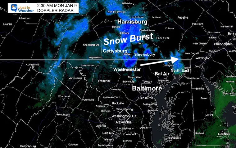
There was a brief heavy burst of snow. If temps were colder, it would have been an issue. Thanks to a warm week and local temps remaining above freezing… any slushy coating quickly melted.
2:30 AM
Which Model Did The Best?
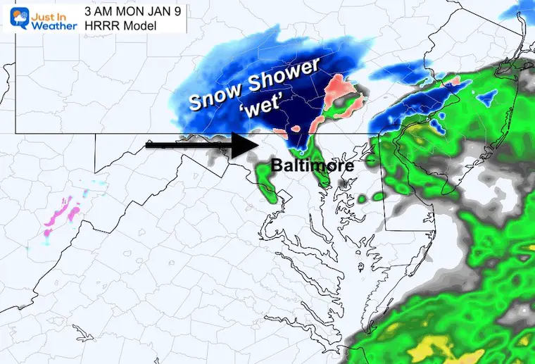
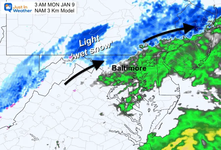
This looks more like the HRRR than the NAM. I hope this sounds familiar: It verified about 1 hour earlier than projected. This is why I often suggest that and will continue to do so with future weather events.
3 AM HRRR (Forecast Last Night)
Very close to the radar snapshot above, just an hour too late.
3 AM NAM 3 Km (Forecast Last Night)
This projection was overdone!
Back To Our Regular Weather
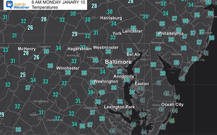
Morning Temperatures
Where is the cold air? There is not much around now as we enter the climatologically coldest part of the year.
Surface Weather
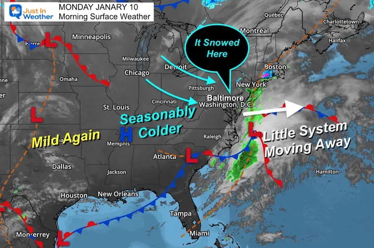
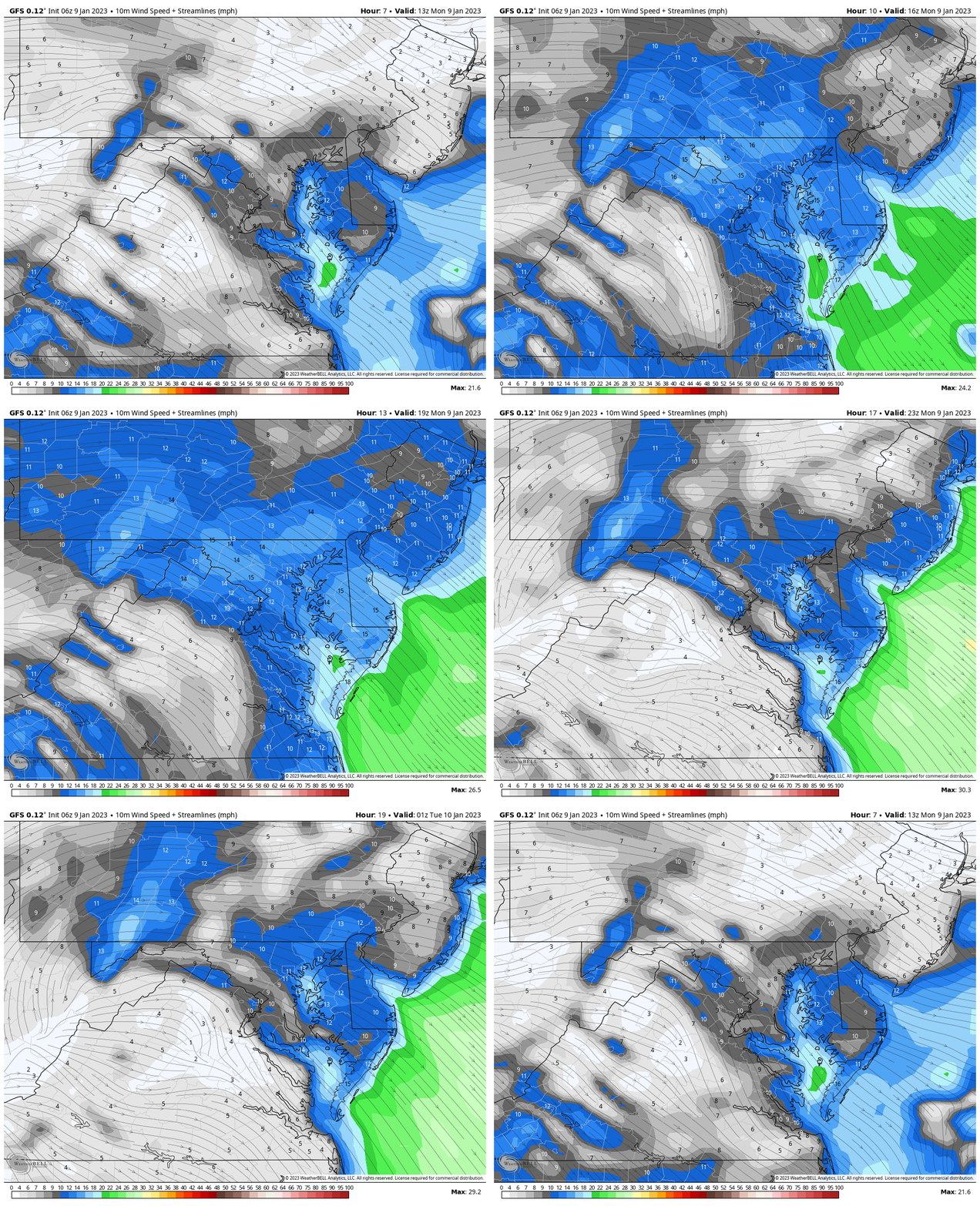
Our little weather system is moving off the coast, allowing for seasonal colder winds to move in. That gusty wind will be noticeable today.
Wind Forecast: 8 AM to 8 PM
Steady winds: 15-20 mph.
Gusts to 25 mph + at times.
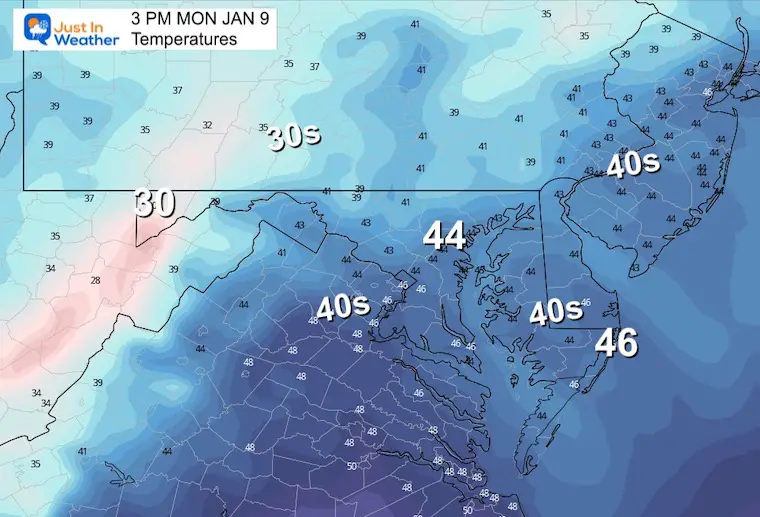
3 PM Temperatures
These numbers are near seasonal average highs. We should see some sun breaking back out.
Subscribe for eMail Alerts
Weather posts straight to your inbox
Sign up and be the first to know!
CLIMATE DATA
TODAY January 9
Normal Low in Baltimore: 26ºF
Record 10ºF in 1970
SNOW: 4.1” 1996
Normal High in Baltimore: 43ºF
Record 75ºF 1973
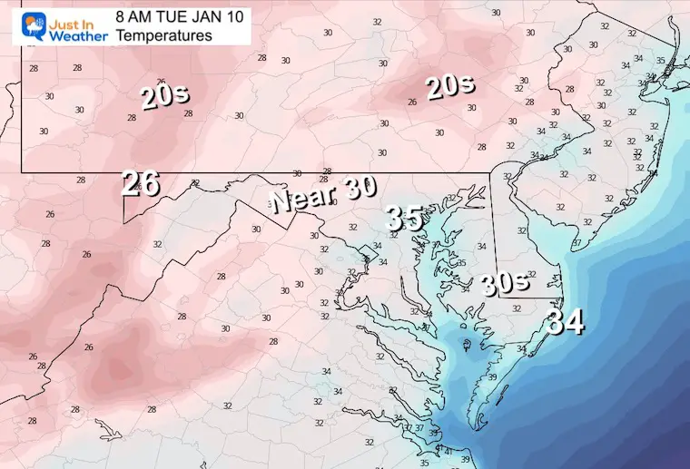
Tuesday Temperatures
Morning
A little closer to normal.
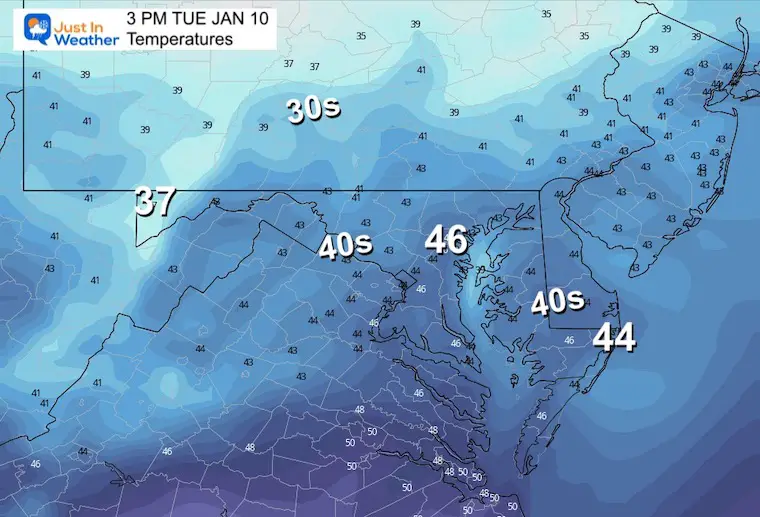
Afternoon
In the reverse of today, Tuesday should bring more clouds in the afternoon.
Looking Ahead:
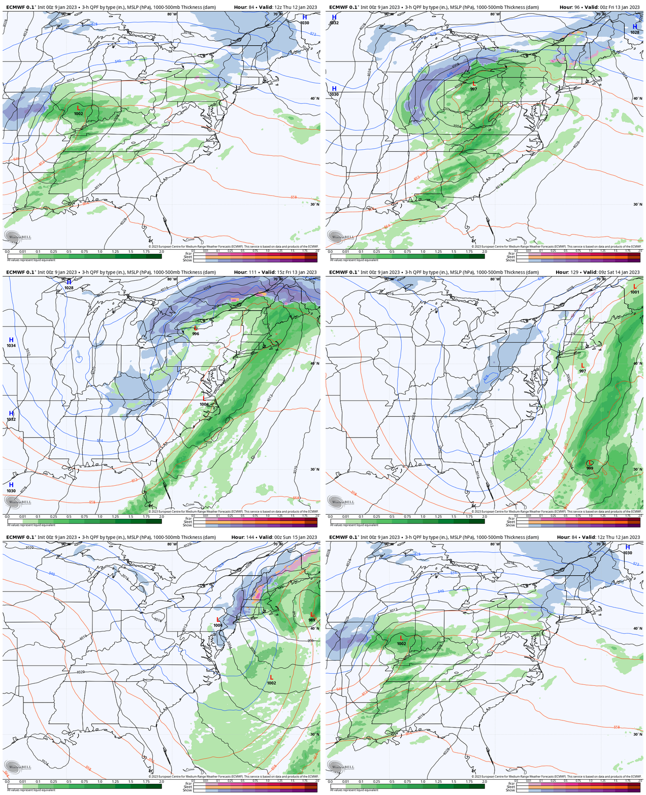
I give in to the warmer solution for the next storm. This will track to our west and north, allowing southerly winds to move in. Storm Animation:
ECMWF Model 7 AM THU to 7 PM SAT
The result may start with rain showers Thursday, then steady and heavier rain Friday.
Behind the storm, we may see enough energy to bring in some flurries with the colder air.
My Thoughts:
The trend is your friend, so we will continue to see mild storms followed by colder air.
Is winter done? Hardly! Most of our snow falls between January 15 to February 28. This mild trend is something we talked about in December. I still see a pattern change AND continue to point out that it often comes a little later than when first shown on the models. I will have a report on that this evening.
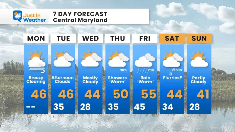
7 Day Forecast
Closer to normal, but no arctic cold. More on the updated outlook in my evening report.
Faith in the Flakes Gear
What is Faith in the Flakes?
It began with my son in 2009
October 27 Nor’easter Recap Still Breezy Then Next Storm Friday
SNOWSTIX – Available Now
STEM Assemblies/In School Fields Trips Are Back
Click to see more and ‘Book’ a visit to your school
My Winter Outlook: Not A Typical La Niña!
I see many factors to support colder influence with multiple systems. Early and later in winter. Check it out.
October 27 Nor’easter Recap Still Breezy Then Next Storm Friday
Also See The Winter Outlook Series:
October 27 Nor’easter Recap Still Breezy Then Next Storm Friday
Farmer’s Almanac Comparison
September Starts Meteorological Autumn: Weather Climate Stats For Maryland at Baltimore
Triple Dip La Niña Winter
CONNECTION TO WINTER?
If you want a snowy winter, this is what you might want to look for in the rest of the tropical season. (You might be seeing a lot of commercial snow removal people out this Winter).
Rainbow Ice Cave In Mt. Rainier A Very Rare Find: Photos And Video
Wooly Bear Caterpillars
https://justinweather.com/2022/10/25/winter-weather-outlook-from-the-wooly-bear-caterpillar/
Persimmon Seeds
Click to see Top 20 and MORE
Winter Weather Folklore Top 20 And More Outlook Signals From Nature For Cold And Snow
Normals And Records: Maryland and Baltimore Climate History
Please share your thoughts, best weather pics/videos, or just keep in touch via social media
-
Facebook: Justin Berk, Meteorologist
-
Twitter: @JustinWeather
-
Instagram: justinweather


