Wednesday December 14 2022
This post will take a look at the latest model simulations for Thursday, December 15 in the Mid Atlantic region. We expect to have freezing rain maybe mixed with sleet at the start between 3 AM and 6 AM. It will be cold enough for initial icing on many surfaces, and the timing may help schools make their calls sooner.
A few hours of heavy precipitation may get that freezing rain to mix with sleet or slushy snow at times as it drags down colder air. I can see why the GFS Model has been pushing it. Either way, 6 AM to 10 AM may get pretty sloppy in our region!
Some of the region will thaw slowly during the morning, while inland areas will remain icy into the early afternoon. That is why the Winter Weather Advisory timing has been extended.
My concern is for moderate to heavy icing in addition to heavy rainfall. I will show you the range of expectations below, but a large area with a glaze to 0.1” is enough to be an issue. Inland colder areas likely to get OVER 0.25” of ice, can lead to some problems with tree branches and some powerlines. Thicker ice will fall in the mountains.
Please Note:
When ice accumulates, it can take a while to thaw after temps slowly rise.
Treated roads will be passable. Untreated surfaces (side roads/sidewalks) and bridges can ice quicker!
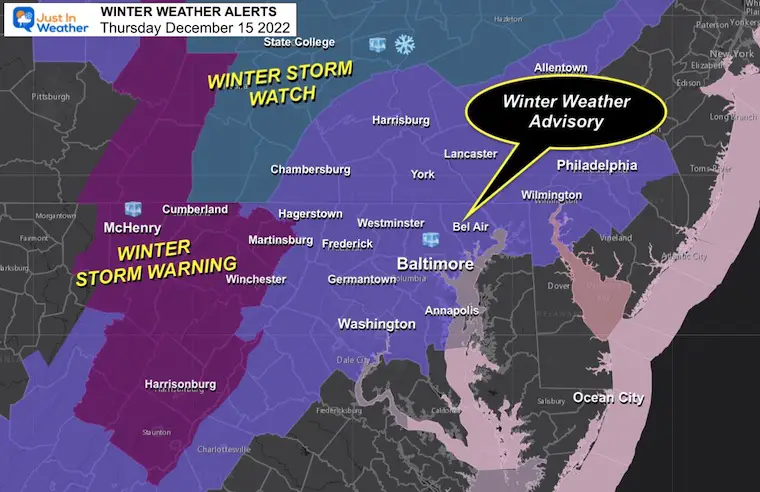
Winter Alerts
I showed this map earlier and the only update is this:
- Central Maryland: Winter Weather Advisory until 1 PM
- (Baltimore and south should thaw between 8 and 11 AM)
- Southern Pennsylvania: Winter Weather Advisory until 7 PM
- Mountains: Heavy Ice Storm West of Hagerstown.
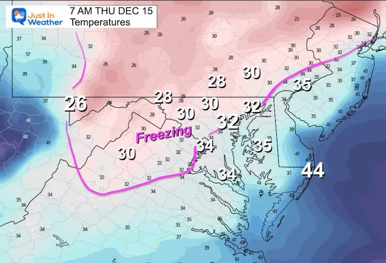
Temperatures
Morning Temperatures represent where ice should fall for a few hours.
Model Animations
The Canadian Model and GFS Model are the lead two in my opinion now. I am sticking with the Canadian GEM for overall behavior, however, I think the totals may be a bit overdone.
I will compare the models per time frame below…
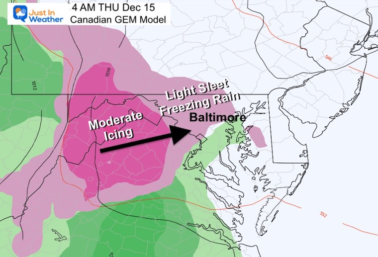
Canadian GEM:
THU 1 AM to FRI 7 AM
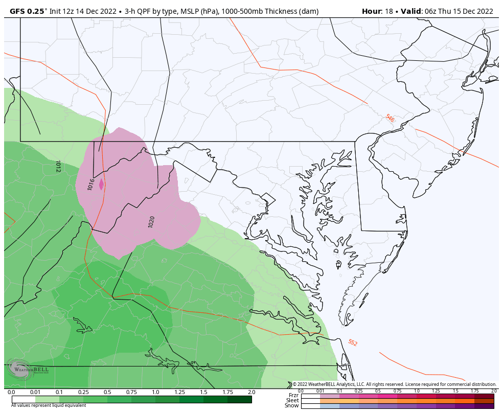
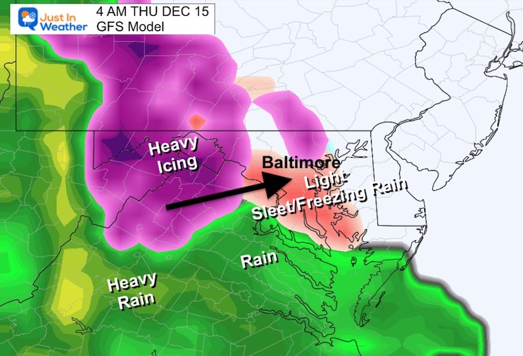
GFS Model:
THU 1 AM to FRI 1 PM
This is the colder solution with a hint of snow mixing late Thursday morning, then ending with snow along the Maryland and Pennsylvania line Friday morning.
Subscribe for eMail Alerts
Key Time Frames
4 AM: Start Time
Light Freezing Rain and/or Sleet will expand between 3 AM and 6 AM through most areas.
The GFS is in agreement with the start time between 3 AM and 6 AM in metro areas.
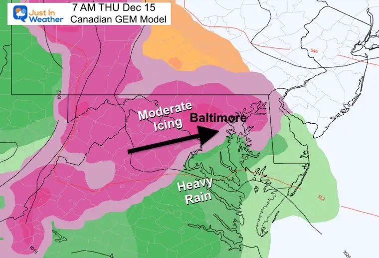
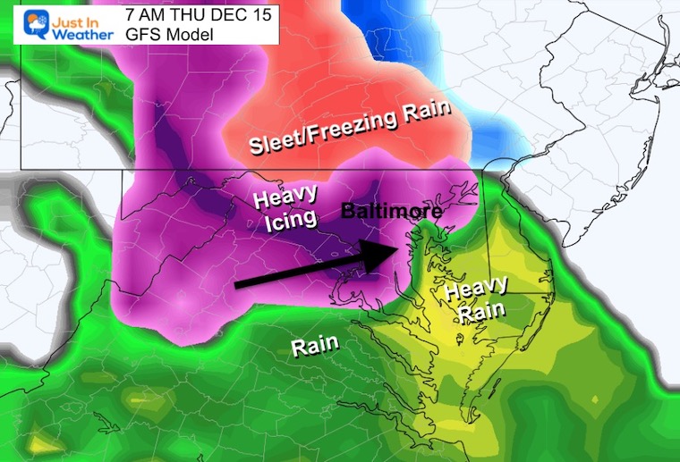
7 AM: Commute Time – Storm In Full Swing
The Canadian Model shows moderate to heavy icing… mainly near I-95 and inland. This includes Harford and Cecil Counties.
This heavier icing may also mix with sleet and snow at times. It will affect roads and possibly schools.
The GFS looks very similar, but there seems to be a surge or burst of heavy icing. This increase in precipitation may drag down colder air and mix in sleet or even snow at times. Travel west of the Bay will be hindered and so will schools I think.
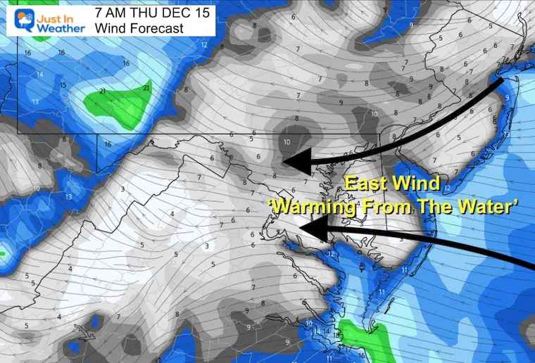
Winds Forecast at 7 AM
This is the wild card as an East wind will mix in water air at mid levels. That is the reason we expect more icy precipitation and not a pure snow. But heavier precipitation could briefly drag colder air down to add in sleet and snow.
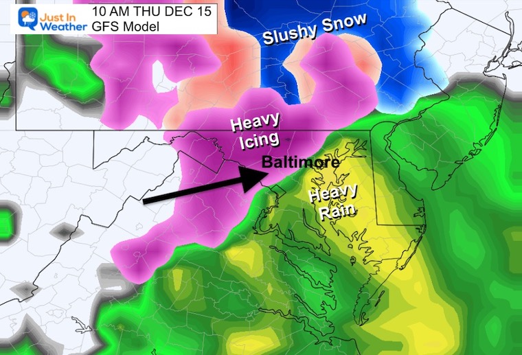
10 AM: Late Morning
Slow Thaw From The South.
Thawing line moving through Baltimore City
This is the hardest part to call…
But with winds FROM THE EAST, warming will be expanding from the Bay.
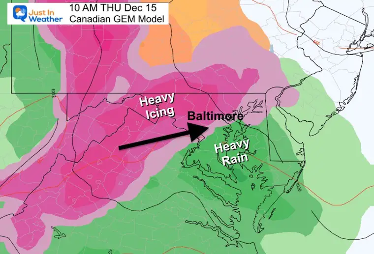
The GFS and Canadian are very similar in the set up, just off about 10 to 20 miles where the ice vs. rain line will set up.
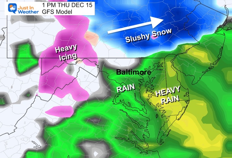
1 PM
Still icing near the PA line. The GFS is showing snow in York and Lancaster Counties.
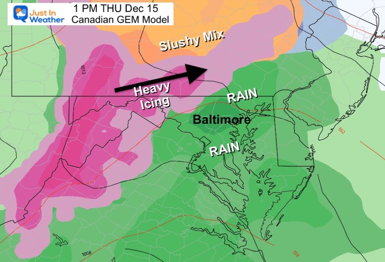
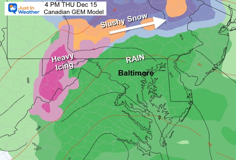
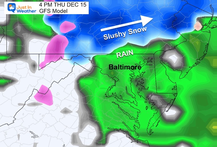
4 PM
Central Maryland: Rain
Southern PA – The ice or snow line will be between York, Lancaster, and Harrisburg
The Canadian Model is a little warmer and pushes the freezing line farther north.
The GFS Model is colder and keeps snow close to York and Lancaster… even in the northern Philadelphia suburbs.
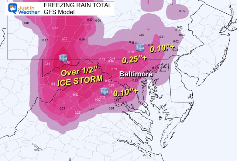
Storm Totals
ICE
This is concerning!
- Over 0.1” is a glaze that will be impactful on untreated surfaces.
- Over .25” is likely in the colder western and northern areas. This can start to weigh on tree branches and weaker power lines.
- Between 0.5: and 1”+ in the mountains will be a debilitating ice storm. More power outages are likely there.
The Canadian Model is showing MORE ICE. In this case, I am leaning towards the amounts shown on the GFS.
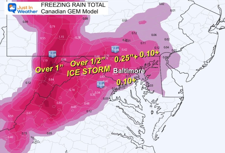
GFS Model
This is a little lower in totals and the model I am leaning towards to verify.
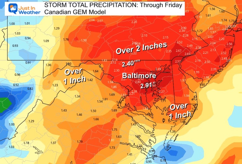
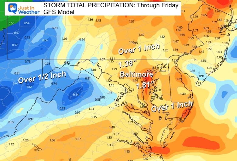
TOTAL PRECIPITATION
Again the Canadian is higher with a broad total of OVER 2 inches. I feel it is safer to lean on the lighter GFS, which is still showing a large area over 1 inch!
Canadian Model
GFS Model
In my opinion, this is more likely to verify.
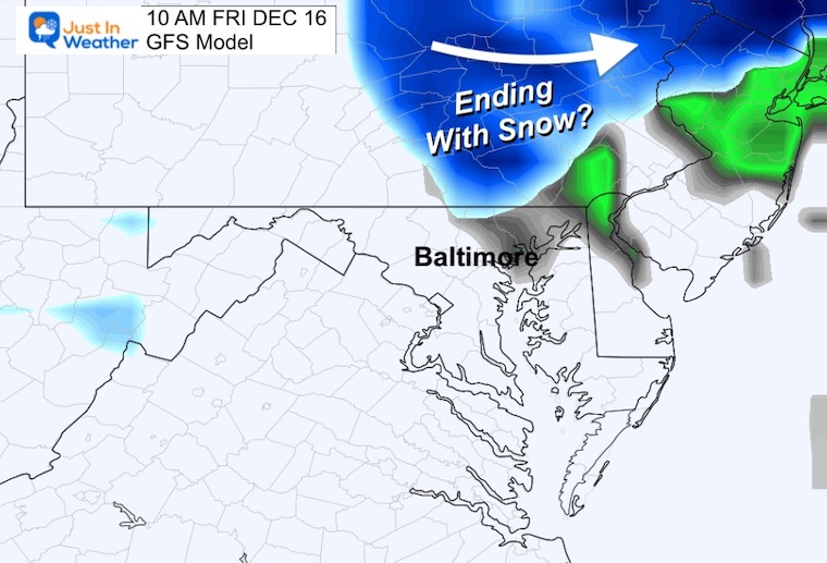
Ending With Snow Friday?
The GFS continues to be the colder model and is showing a band of snow clipping northern Maryland between 7 AM and 10 AM.
I will post My Final Call in my evening report. Keep in mind that there still may be flurries this weekend and a colder push before Christmas. FITF
Faith in the Flakes Gear

What is Faith in the Flakes?
It began with my son in 2009
October 27 Nor’easter Recap Still Breezy Then Next Storm Friday
SNOWSTIX – Available Now

STEM Assemblies/In School Fields Trips Are Back
Click to see more and ‘Book’ a visit to your school

My Winter Outlook: Not A Typical La Niña!
I see many factors to support colder influence with multiple systems. Early and later in winter. Check it out.
October 27 Nor’easter Recap Still Breezy Then Next Storm Friday
Also See The Winter Outlook Series:
October 27 Nor’easter Recap Still Breezy Then Next Storm Friday
Winter Outlook 2023 La Niña Triple Dip Expectations
Farmer’s Almanac Comparison
September Starts Meteorological Autumn: Weather Climate Stats For Maryland at Baltimore
Triple Dip La Niña Winter
Winter Outlook 2023 La Niña Triple Dip Expectations
CONNECTION TO WINTER?
If you want a snowy winter, this is what you might want to look for in the rest of the tropical season. (You might be seeing a lot of commercial snow removal people out this Winter).
Rainbow Ice Cave In Mt. Rainier A Very Rare Find: Photos And Video
Wooly Bear Caterpillars
https://justinweather.com/2022/10/25/winter-weather-outlook-from-the-wooly-bear-caterpillar/
Persimmon Seeds
Winter Weather Outlook: Persimmon Seeds And Snow Folklore
Click to see Top 20 and MORE
Winter Weather Folklore Top 20 And More Outlook Signals From Nature For Cold And Snow
Normals And Records: Maryland and Baltimore Climate History

Please share your thoughts, best weather pics/videos, or just keep in touch via social media


