


May 12 Mothers Day Showers And Another Aurora Viewing Tonight May Be Better
Sunday May 12 Mother's Day Morning Report Today, we focus on the all-important Mother’s Day weather and the ongoing impact of the latest Solar Storm. We have been stuck in…
Wednesday Night Update
December 14 2022
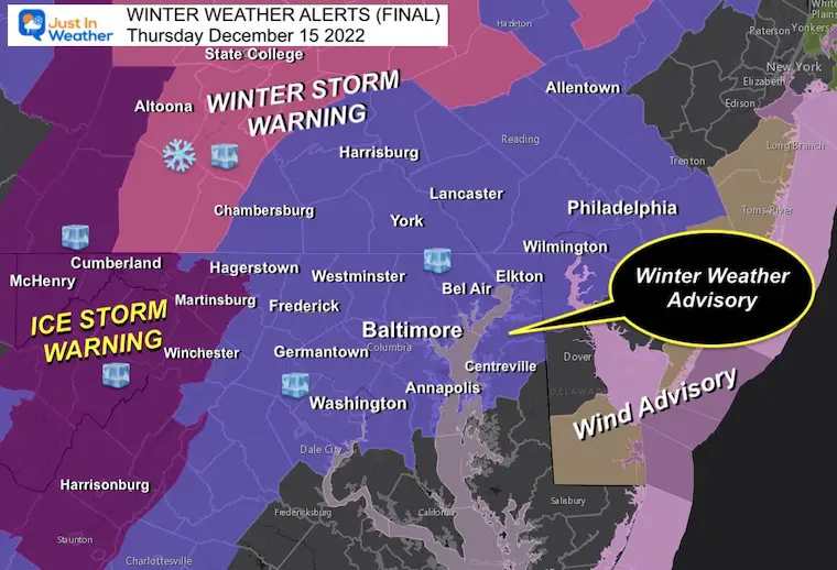
Yes, I called this an ice storm. It will be impactful and there is an official Ice Storm Warning in Western Maryland. This is one of the classic complicated weather events that will not affect everyone the same way. I will do my best to simplify my thoughts and hopefully what you can expect.
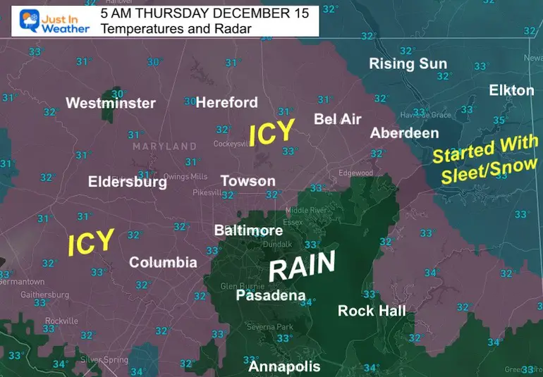
Click Here For Local Maps With Temps And Radar For Icing Suggestion
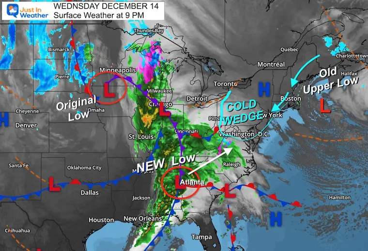
This storm looks like a ragged mess, but it is reorganizing.
The original Low that brought a blizzard to the northern plains has occluded.
The NEW Low is reforming near Atlantic and the trailing cold front has been responsible for the severe storm and tornado outbreak in the South! I must say, this southern plot is more in line with the GFS solution I’ve been sharing with you.
High Pressure still located over The Mid Atlantic is getting pinched off, while an Old Upper Low East of Boston is creating a road block. This is helping lock in a wedge of cold air, which appears to be trending just a little colder.
The freezing air has already settled in, and temps will drop a few more degrees to allow for more to catch up. The dry air will cool just as the first precipitation arrives with virga. Evaporative cooling will chill and lock in the cold air wedge. Where that wedge will set up is tricky, but that’s why more areas were added to the Winter Weather Advisory (see the new map below).
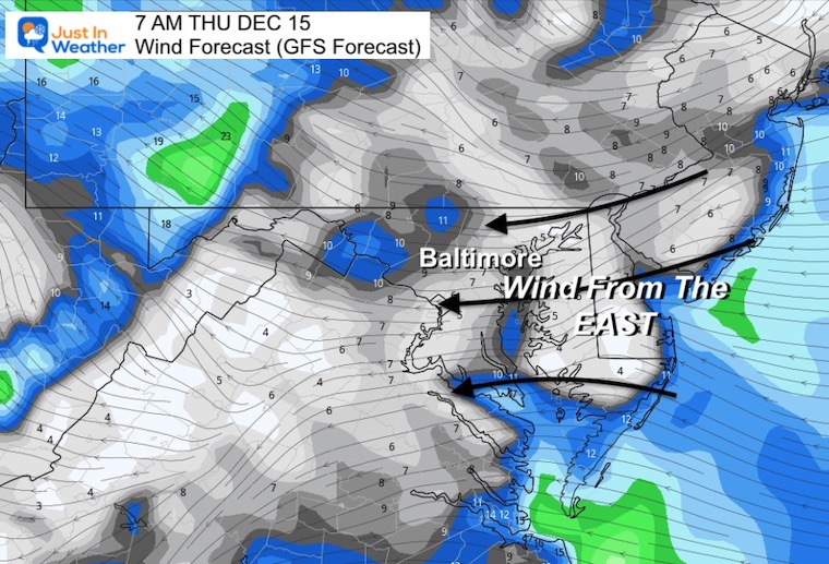
The surprising note here is where I put the ‘?’ – Freezing on Delmarva. Winds off the water should warm them tomorrow, but I am intrigued by the cold located there as winds will move from the East tomorrow morning.
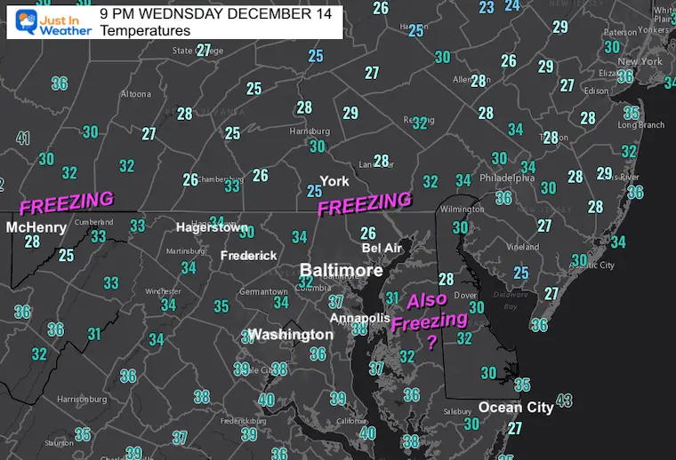
Notice the mix of 32ºF to 34ºF along I-95 through Baltimore and Washington.
From the East is warming this time of the year. The water temperature at Thomas Point Lighthouse is 39ºF, so that is the influence in urban areas and around I-95.
The impact of this vs. the approaching storm dynamics is what makes it complicated to pin down the freezing line.
The easy part of this is the timing, and thankfully our atmospheric memory has followed from Fall to bring in precipitation before sunrise. This is helpful for many to know early enough what is falling and how it is impacting roads, so a decision to not travel can be made.
I had a discussion with one of my clients today and am glad to see others thinking the same way and make an early call for delay, then reevaluate and see the impact of the icing. If you are in a lucky zone where this has already been mentioned, then you get to stay up late and read this, plus sleep in longer… or wake up like a kid and look for your school to be closed.
For example, Baltimore County already publicly announced a 2 Hour Delay, with expectation to reevaluate and update by 6:15 AM. I think this is a wise and cautious way to approach an icing event.
(1/2) ALERT: Baltimore County Public Schools, including the Virtual Learning Program, will open two hours late on Thursday, December 15, 2022, due to expected inclement weather. Morning Prekindergarten classes are cancelled.
— Baltimore County Public Schools (@BaltCoPS) December 14, 2022
Harford County Public School made a similar call
Due to forecasted conditions, HCPS, including Swan Creek, and offices will open 2 hours late Thursday, December 15, 2022. No morning Pre-K or before-school childcare. Essential personnel await further info. Any necessary re-evaluation will be made by 6:30 a.m. tomorrow.
— HCPS (@HCPSchools) December 14, 2022
I was in Anne Arundel County for a school visit this morning. I told Pasadena ES that there is a 50% chance they would need a delay, as they are on the southern edge of the expected freezing.
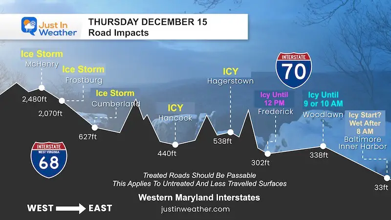
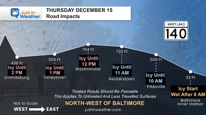
I have working with my friend and graphic artist Casey Berry on new ways to help show snow forecasts for travelers. They are not all ready yet, however I felt I needed to grab the first two and apply them to this event for people who travel these routes. I’d love to know if you find them helpful and I will have more during the winter ahead.
They apply to general conditions in those areas that are not treated or less traveled side roads/side walks. Interstates will be heavily worked with chemicals but still could get icy.
Between Baltimore and Western Maryland
From Baltimore to Frederick County
Please see my Local Notes explaining the areas below, followed by forecast maps.
This is where parts of the county may be close to freezing for the starting hours.
This area may also mix in more sleet and even have a burst of snow
Thawing more likely close to or after Noon
This thick ice can break branches, weigh down power lines, and take longer to thaw.
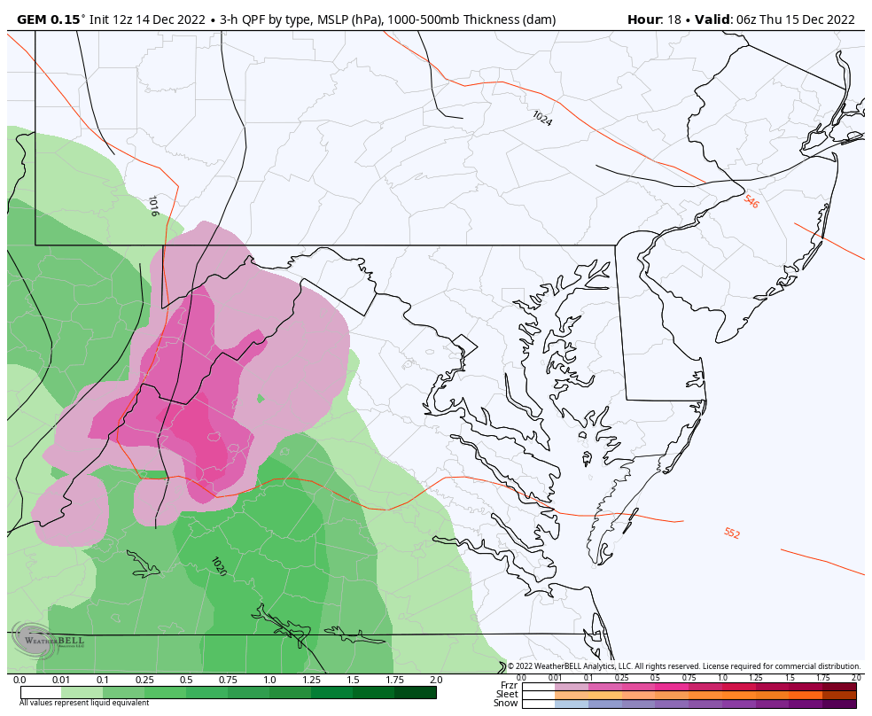
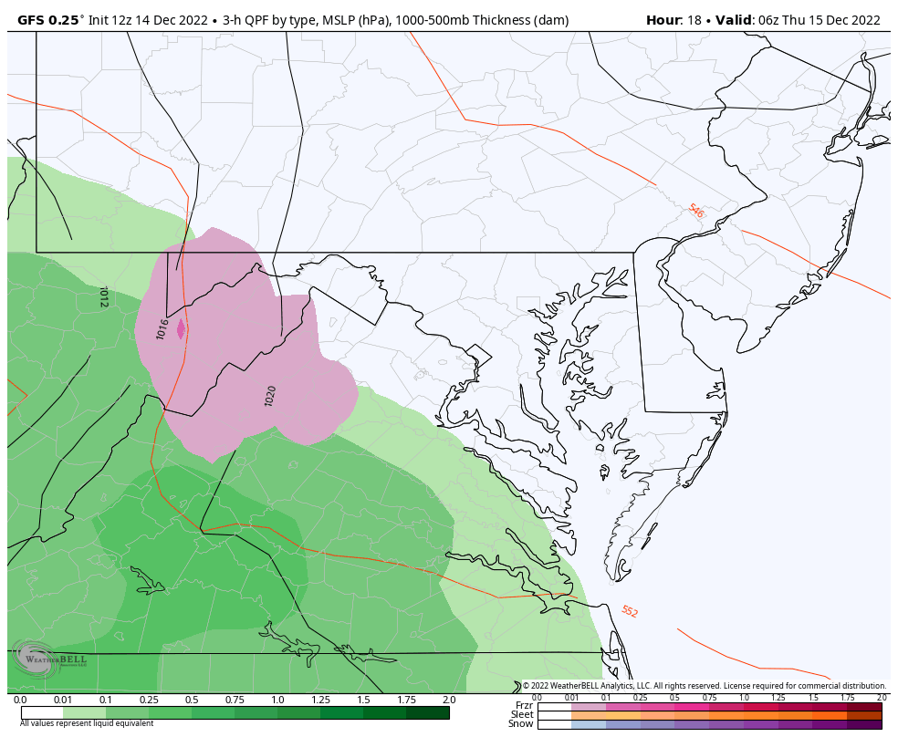
The Canadian Model and GFS Model are the lead two in my opinion now. I am sticking with the Canadian GEM for overall behavior, however, I think the totals may be a bit overdone.
I will compare the models per time frame below…
THU 1 AM to FRI 7 AM
THU 1 AM to FRI 1 PM
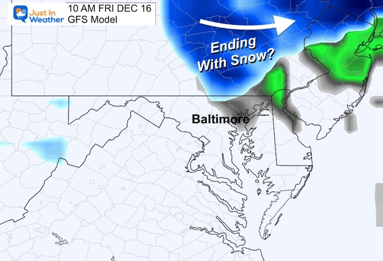
This is the colder solution with a hint of snow mixing late Thursday morning, then ending with snow along the Maryland and Pennsylvania line Friday morning.
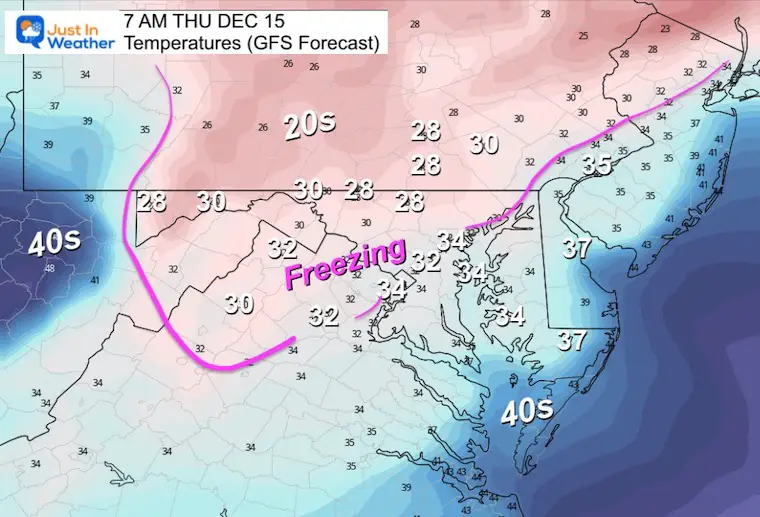
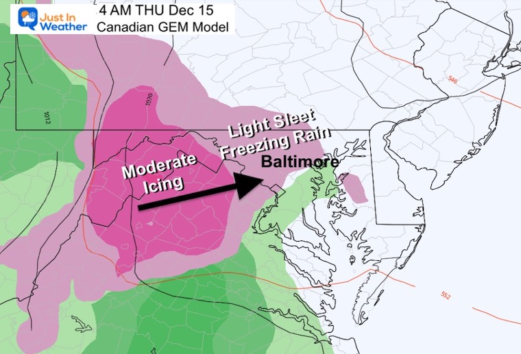
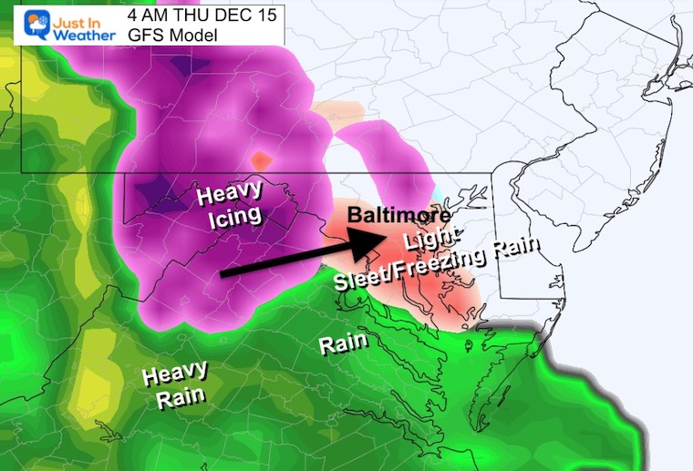
4 AM: Start Time
Light Freezing Rain and/or Sleet will expand between 3 AM and 6 AM through most areas.
The GFS is in agreement with the start time between 3 AM and 6 AM in metro areas.
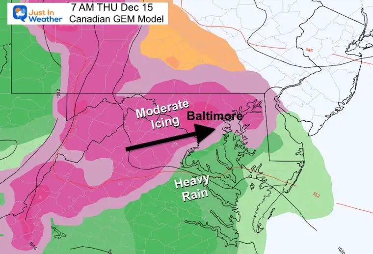
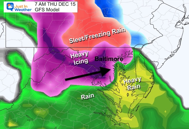
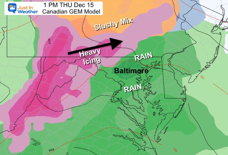
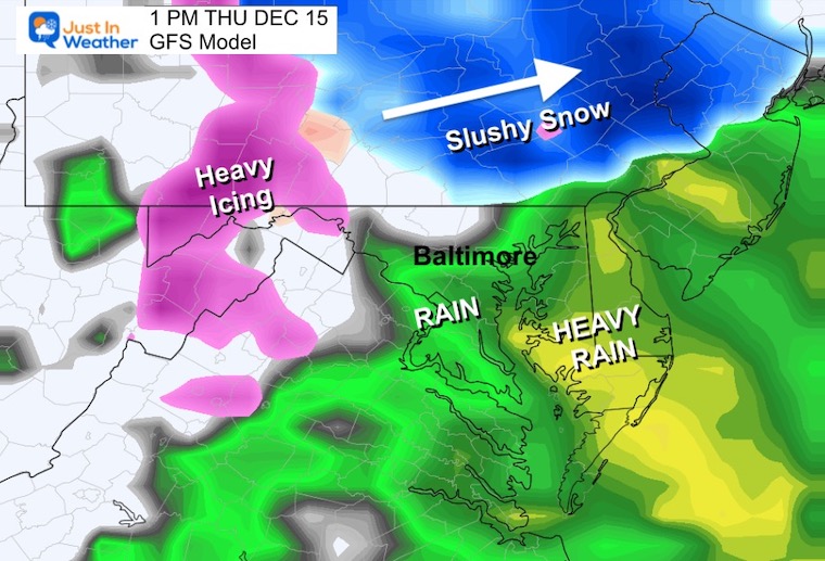
7 AM: Commute Time – Storm In Full Swing
The Canadian Model shows moderate to heavy icing… mainly near I-95 and inland. This includes Harford and Cecil Counties.
This heavier icing may also mix with sleet and snow at times. It will affect roads and possibly schools.
The GFS looks very similar, but there seems to be a surge or burst of heavy icing. This increase in precipitation may drag down colder air and mix in sleet or even snow at times. Travel west of the Bay will be hindered and so will schools I think.
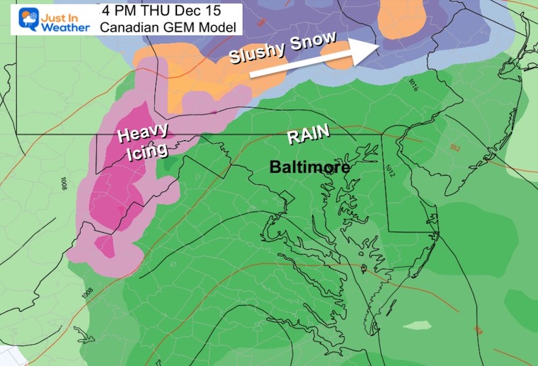
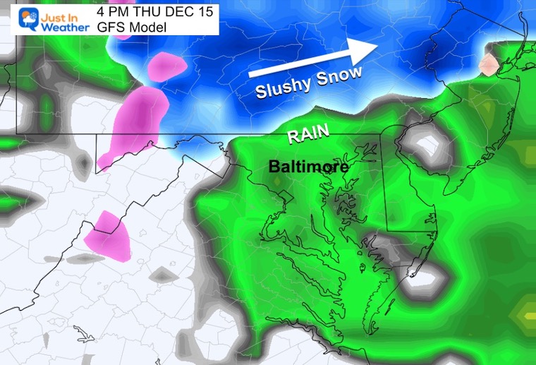
Slow Thaw From The South.
Thawing line moving through Baltimore City
This is the hardest part to call…
But with winds FROM THE EAST, warming will be expanding from the Bay.
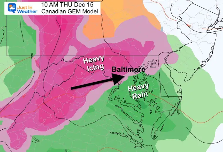
The GFS and Canadian are very similar in the set up, just off by about 10 to 20 miles where the ice vs. rain line will set up.
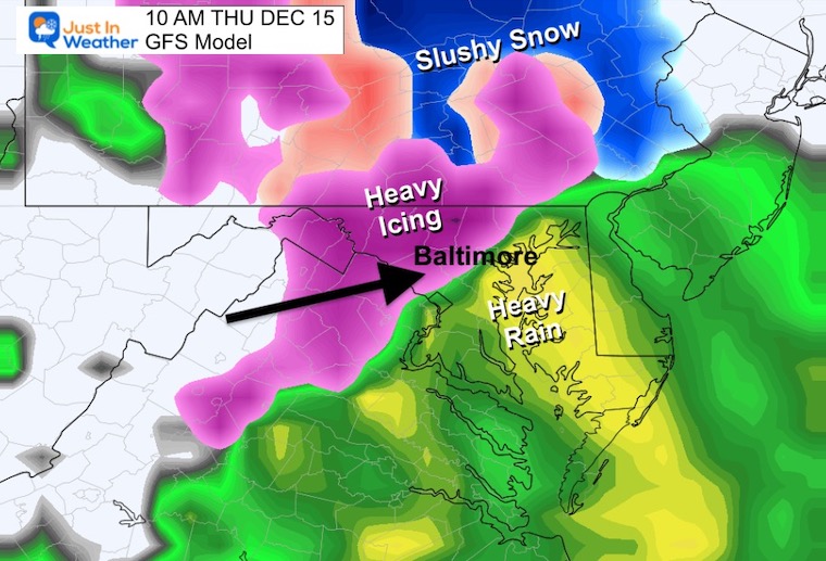
Still icing near the PA line. The GFS is showing snow in York and Lancaster Counties.
Central Maryland: Rain
Southern PA – The ice or snow line will be between York, Lancaster, and Harrisburg
The Canadian Model is a little warmer and pushes the freezing line farther north.
The GFS Model is colder and keeps snow close to York and Lancaster… even in the northern Philadelphia suburbs.
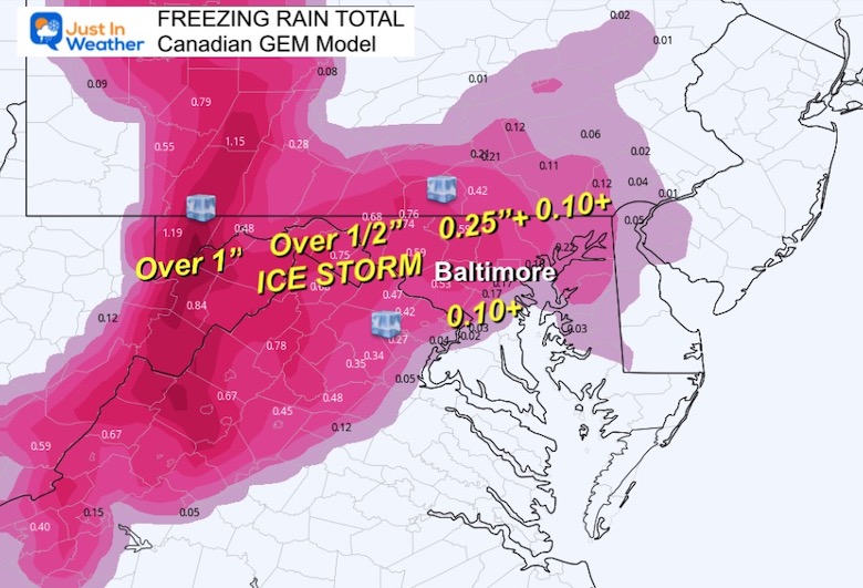
This is concerning!
The Canadian Model is showing MORE ICE. In this case, I am leaning towards the amounts shown on the GFS.
GFS Model
This is a little lower in totals and the model I am leaning towards to verify.
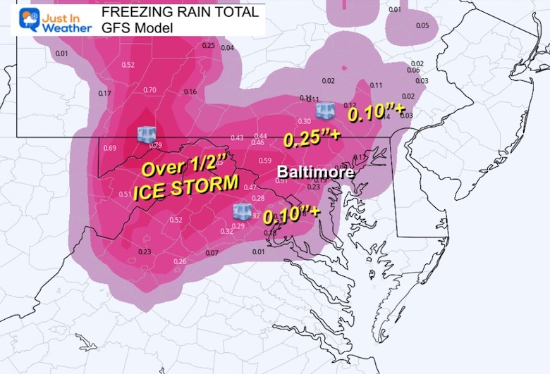
Again the Canadian is higher with a broad total of OVER 2 inches. I feel it is safer to lean on the lighter GFS, which is still showing a large area over 1 inch!
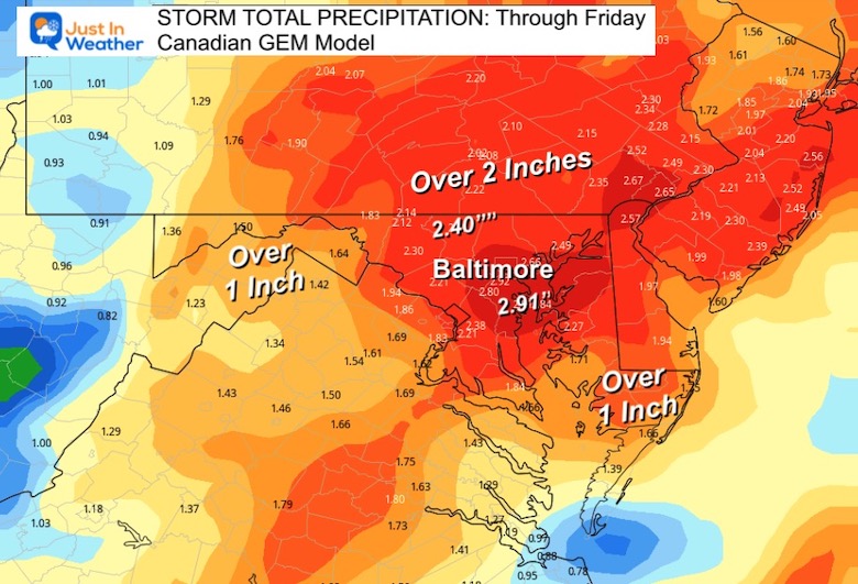
Canadian Model
GFS Model
In my opinion, this is more likely to verify.
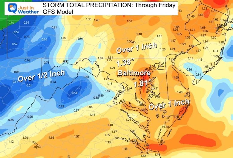
The GFS continues to be the colder model and is showing a band of snow clipping northern Maryland between 7 AM and 10 AM.
I will post My Final Call in my evening report. Keep in mind that there still may be flurries this weekend and a colder push before Christmas. FITF

December 5th Snow In Baltimore And The Start Of Faith In The Flakes FITF

Click to see more and ‘Book’ a visit to your school

I see many factors to support colder influence with multiple systems. Early and later in winter. Check it out.
Winter Outlook 2023 For Snow Not Typical La Niña Plus Polar Vortex Disruption
Atmospheric Memory Suggests Active Winter Storm Pattern Outlook
Winter Outlook 2023 From NOAA Very Different Than Farmers Almanacs
Winter Outlook 2023 Early Look At Snow From Two Farmers Almanacs
If you want a snowy winter, this is what you might want to look for in the rest of the tropical season. (You might be seeing a lot of commercial snow removal people out this Winter).
Record August For No Named Tropical Storms: Closer Look At Snow Following
Winter Weather Folklore Top 20 And More Outlook Signals From Nature For Cold And Snow
