November 30 Weather Rainy Plus Strong Winds The Bigger Story
November 30 2022
Wednesday Morning Update
This last day of the month will be memorable. Today’s weather system has already brought in the rain a little earlier than expected, and it will expand across the region for the morning commute. See the live radar and forecast simulation to compare below.
However, the main story today will be about strong winds that could gust to 50 mph. the strongest winds are likely with the final line of storms passing metro areas between 2 PM and 4 PM.
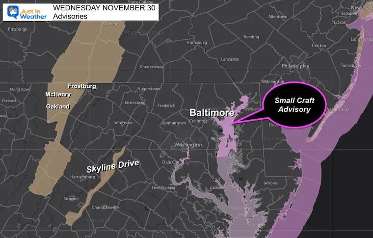
Advisory Map
The Wind Advisories as of this morning are confined to the mountains (for now) with Small Craft Advisories on the Bay. I would still consider securing your outside decorations and pay attention for any wind restrictions.
Also See: MDOT Road Information
Headlines
- Morning: Rain steady 7 AM to 11 AM, Breezy
- Mid Day: Showers
- Afternoon: Winds Gust to 50 mph (3 PM to 6 PM)
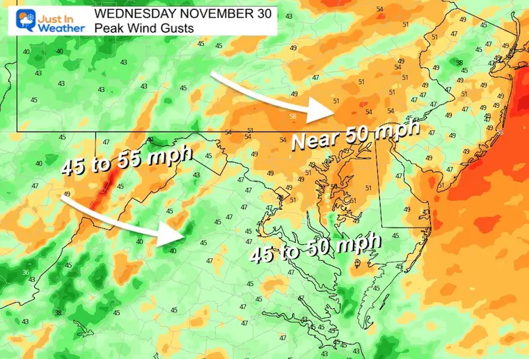
Peak Wind Gusts
Most areas will have gusts approaching the 45 to 50 mph range.
Reminder: This can knock down tree branches, holiday decorations, take trash cans down the street, and possibly lead to some restriction on bridges.
If you are flying or meeting someone arriving, there may be delays, and definitely turbulence to talk about.
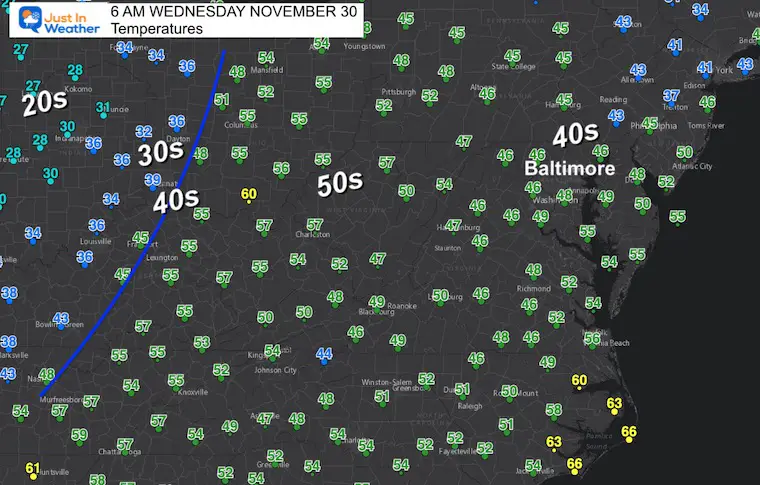
Morning Temperatures
Notice the 20s and 30s in the Mid West… That is the air mass moving in behind this weather system.
Locally we will have a mild morning with southerly winds pushing mid 40s to near 50ºF.
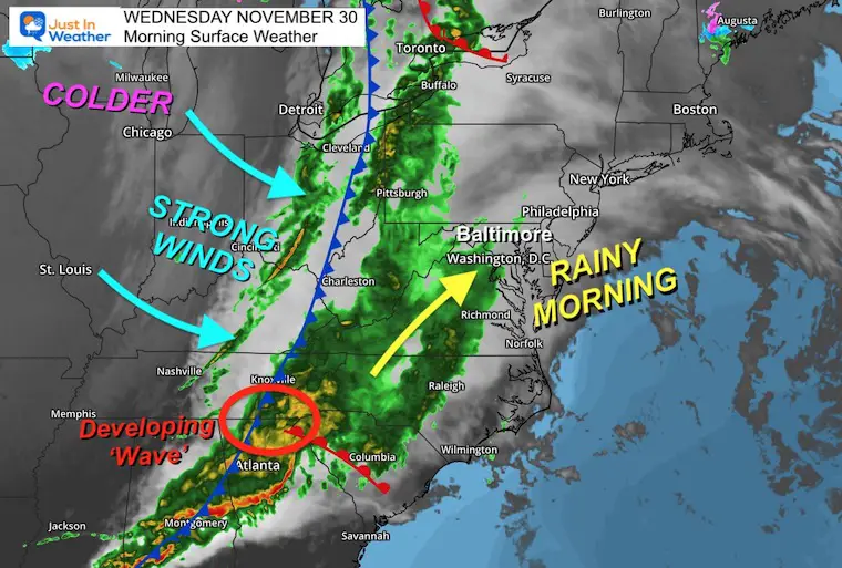
Morning Surface Weather
A strong cold front is moving through eastern Ohio and will cross our region this afternoon. A Mesolow/Wave is trying to develop in northern Georgia out of the severe complex from yesterday. This will enhance the rain for southern areas in addition to the instability above.
If you are flying there maybe delays, definitely turbulence!
Forecast Snapshot (7 AM)
The HRRR Model is updated the most frequently, and yet the rain again arrived earlier than shown here. Compare to the live radar below.
Live Radar Widget
Radar Simulation
7 AM to 7 PM
Key Timeframes
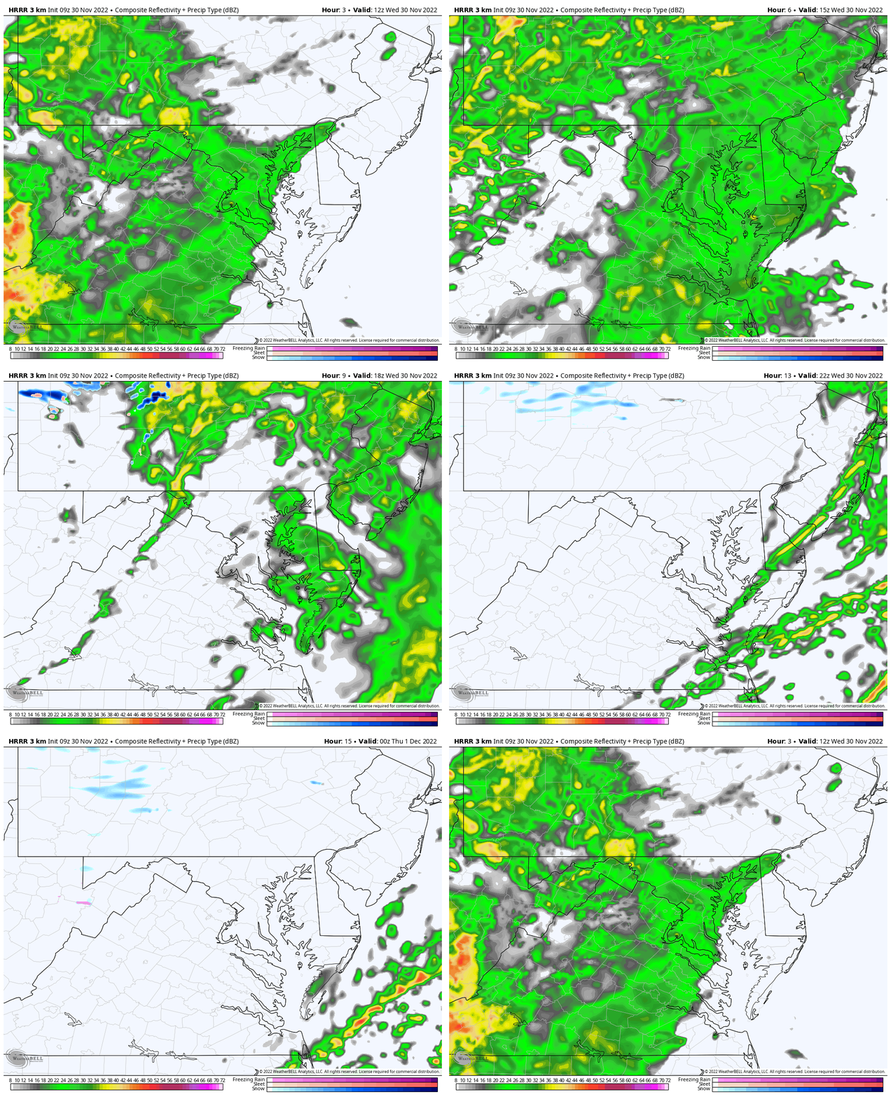
Noon
The steady rain will be moving east, but scattered showers will continue into the afternoon.
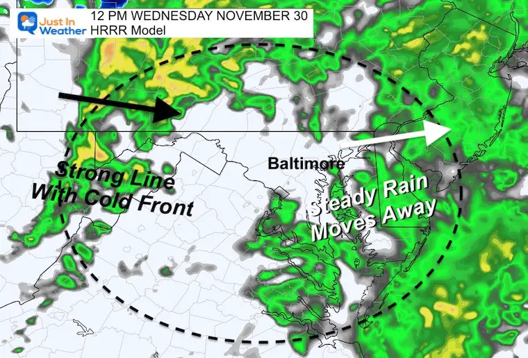
3 PM
This is the cold front, or squall line. The final push of rain and strongest wind gusts are expected within an hour or two of this passing.
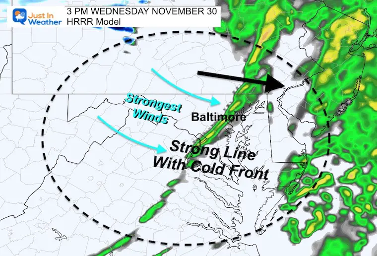
3 PM Temperatures
This shows that cold front very well. With the wind gusts, temps will drop at least 10 degrees.
Wind Forecast
7 AM to 7 PM
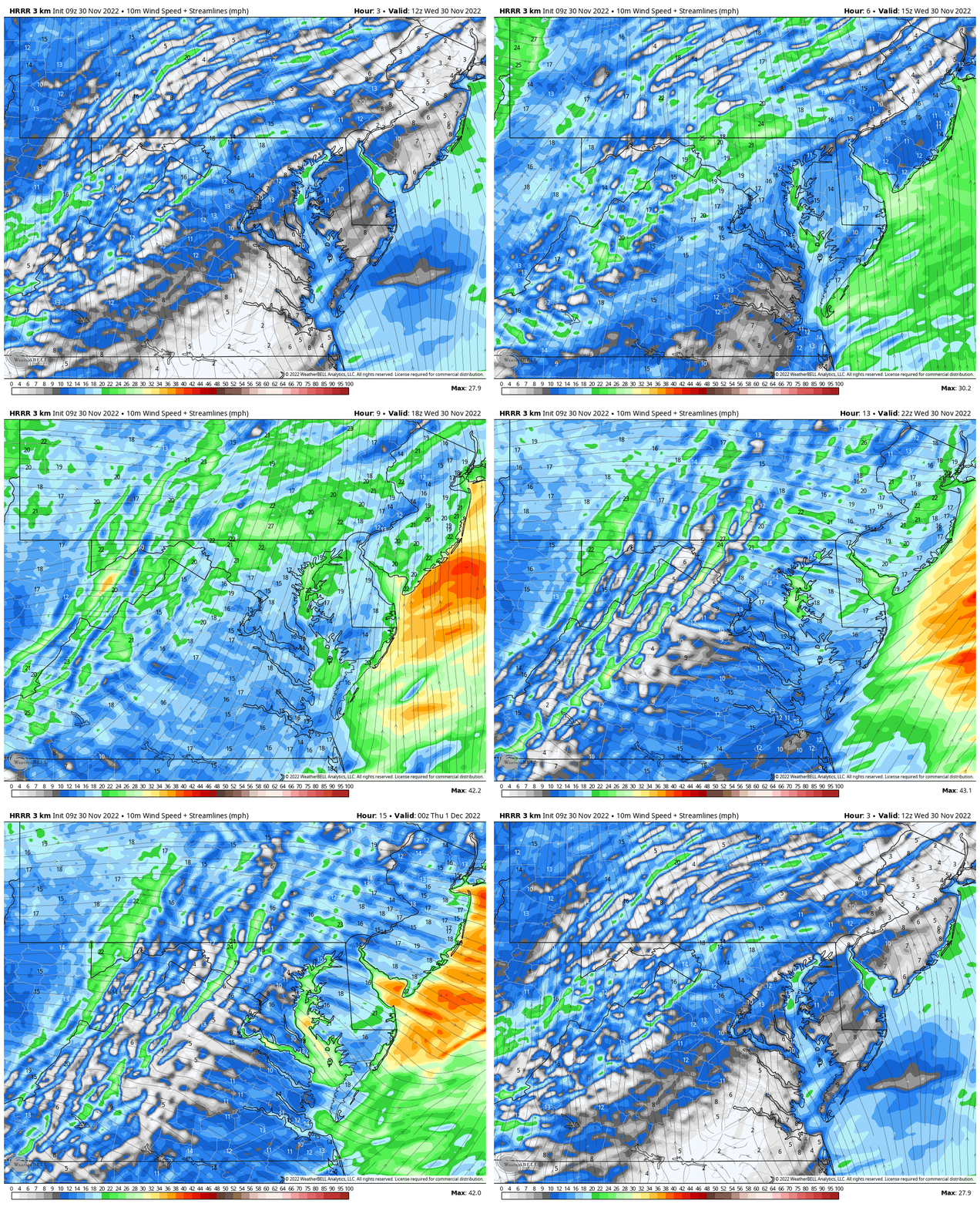
Peak Wind Gusts
Most areas will have gusts approaching the 45 to 50 mph range.
Reminder: This can knock down tree branches, holiday decorations, take trash cans down the street, and possibly lead to some restriction on bridges.
If you are flying or meeting someone arriving, there may be delays, definitely turbulence to talk about.

NEW Faith In The Flakes Gear
https://shop.justinweather.com/
CLIMATE DATA
TODAY November 30
Normal Low in Baltimore: 33ºF
Record 12ºF in 1929
SNOW: 8.4 inches in 1967
Normal High in Baltimore: 52ºF
Record 74ºF 1933
NEW REPORTS:
Record Snow Cover Across The Northern Hemisphere
December Pattern Change
Subscribe to my Newsletter
Weather posts straight to your inbox
Sign up and be the first to know!
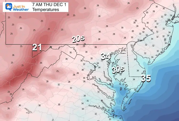
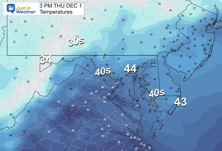
Thursday Temperatures
Morning
Much colder and still breezy.
Afternoon
Chilly and some wind chill may be worth mentioning.
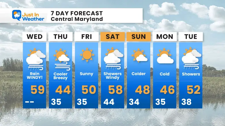
7 Day Forecast
The 3 day cycle seems to be on repeat.
My Winter Outlook: Not A Typical La Niña!
I see many factors to support colder influence with multiple systems. Early and later in winter. Check it out.
October 27 Nor’easter Recap Still Breezy Then Next Storm Friday
Also See The Winter Outlook Series:
October 27 Nor’easter Recap Still Breezy Then Next Storm Friday
Farmer’s Almanac Comparison
September Starts Meteorological Autumn: Weather Climate Stats For Maryland at Baltimore
Triple Dip La Niña Winter
CONNECTION TO WINTER?
If you want a snowy winter, this is what you might want to look for in the rest of the tropical season. (You might be seeing a lot of commercial snow removal people out this Winter).
Rainbow Ice Cave In Mt. Rainier A Very Rare Find: Photos And Video
Wooly Bear Caterpillars
https://justinweather.com/2022/10/25/winter-weather-outlook-from-the-wooly-bear-caterpillar/
Persimmon Seeds
Click to see Top 20 and MORE
Winter Weather Folklore Top 20 And More Outlook Signals From Nature For Cold And Snow
Faith in the Flakes Gear
SNOWSTIX – Available Now
Normals And Records: Maryland and Baltimore Climate History
STEM Assemblies/In School Fields Trips Are Back
Click to see more and ‘Book’ a visit to your school
Please share your thoughts, best weather pics/videos, or just keep in touch via social media
-
Facebook: Justin Berk, Meteorologist
-
Twitter: @JustinWeather
-
Instagram: justinweather


