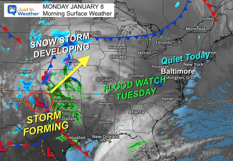
Monday Jan 8 2024
The next winter storm is going to be a large impact event for much of the nation. It will be a winter storm that primarily brings our region heavy rain and high wind. The focus of this report will be the wind factor, as it may bring damage and power outages.
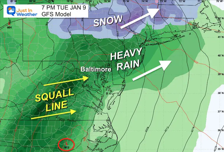
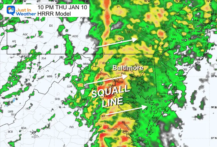
While the storm will cover most of Tuesday, the worst part will be with a developing squall line along the cold front. This will cross our region after dark Tuesday evening through midnight. That is when the strongest winds AND heaviest rain will occur. So, conditions will deteriorate throughout the day.
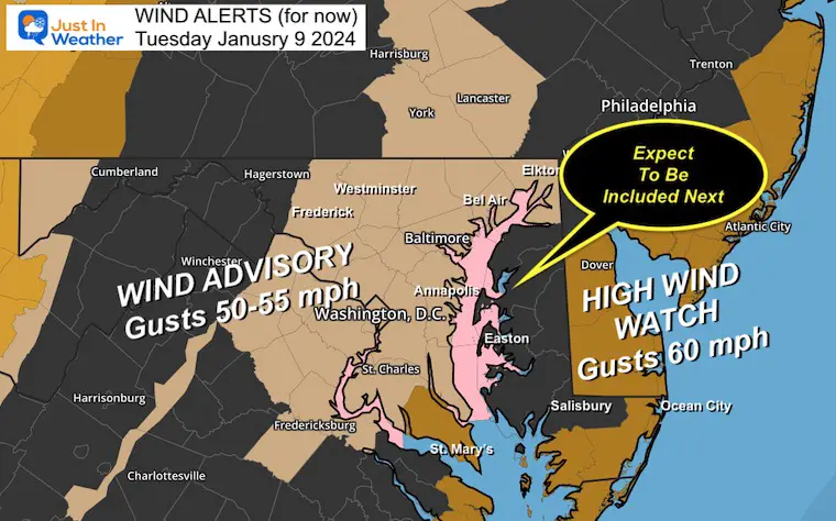
I am posting this with the anticipation that many alerts will be upgraded to Advisories or more warnings… Including filling in the counties on the MD Eastern Shore.
WIND ALERTS
This map may be confusing with the absence of notifications for Maryland’s Eastern Shore. This shows the lack of coordination between National Weather Service offices. There are a few that cover Maryland.
Wind Advisory: 3 PM Tue to 1 AM Wed
High Wind Watch: (coastal areas)
- 4 PM Tue to 4 AM Wed
- Wind Gusts 60 mph – or higher
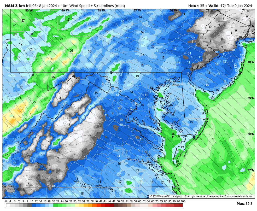
Wind Forecast Animation
Noon to Midnight
Note: The Southerly air flow will result in Coastal Flooding on the Chesapeake Bay!
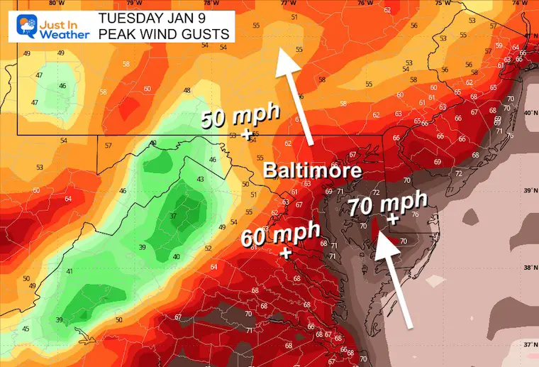
Peak Wind Gusts
50 to 70+ mph (Delmarva) Between 7 PM and Midnight
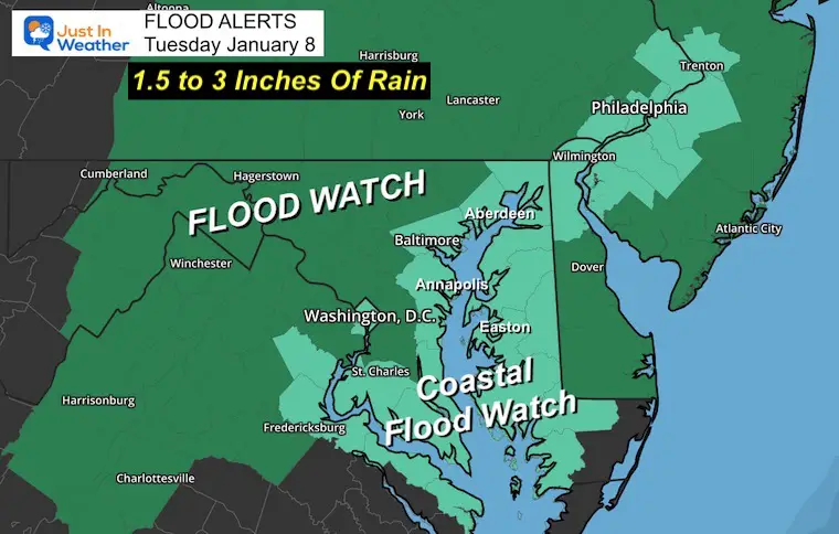
Flood Watch
More Storm Maps Below
There will be flooding from high water in the Chesapeake Bay as strong winds will be developing from the South. There have been High Wind Watches posted, and more will be added today. If you are traveling on Tuesday, consider the impacts with restrictions likely on bridges and flight delays or cancellations. The storm will cover a large area.
Sadly, this storm pattern may repeat Friday night into Saturday.
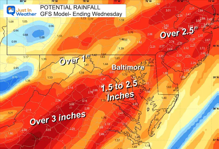
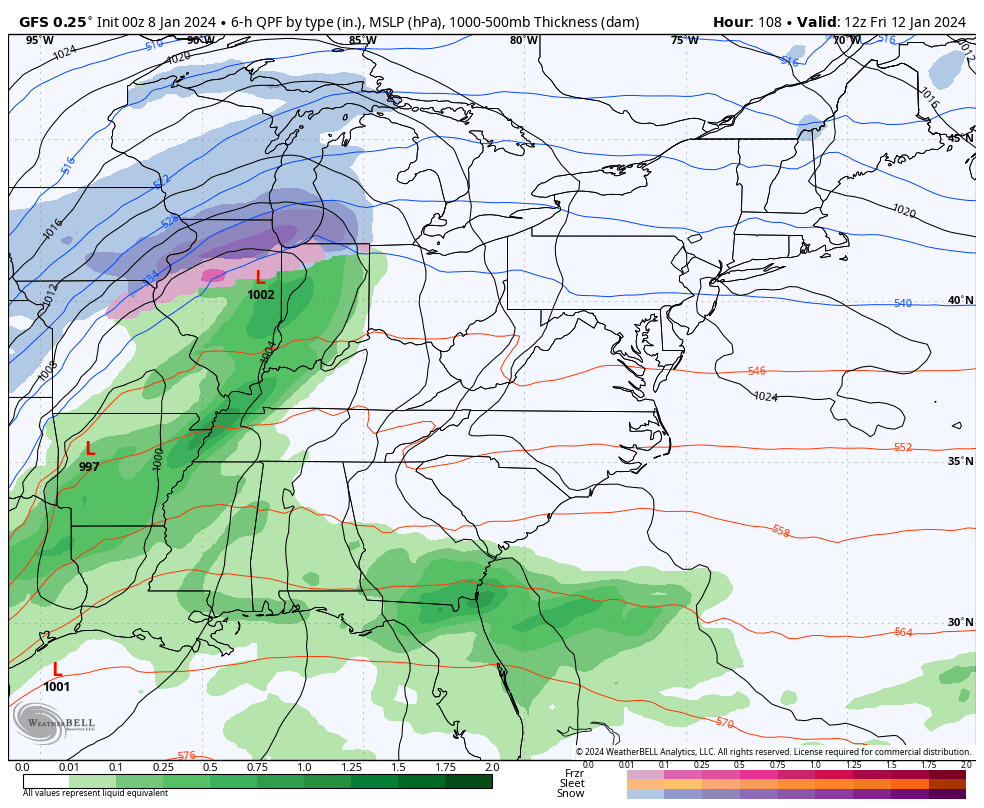
Rainfall Potential
Morning Surface Weather
We will have a nice and seasonably cool day. The Storm is developing across North Texas and will take a track to the western Great Lakes. It will be a major snow event for the Northern Plains, but on the east side, it will pull up warm and very unstable air. That is why we will expect flooding rain in addition to damaging winds Tuesday night.
Storm Animation Tuesday Morning To Wednesday Evening
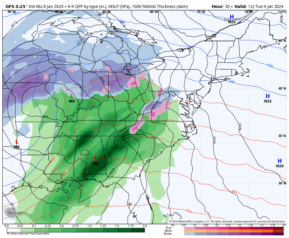
GFS Model
Storm Snapshot Tuesday Night
This squall line will bring the heaviest rain AND strongest winds from 7 PM to Midnight.
High-Resolution Nam 3 Km Model
NEXT STORM: Friday to Saturday
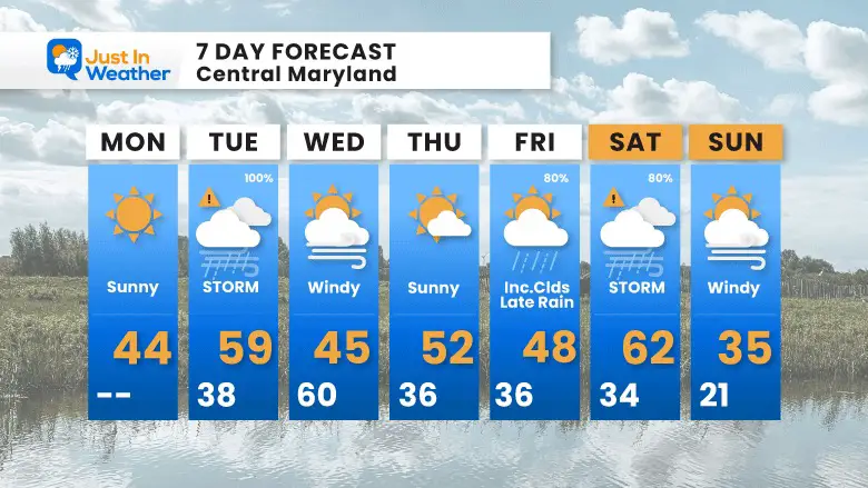
7 Day Forecast
Two storms this week will follow a very similar pattern and may bring us similar results.
The colder air will try to move in after the weekend storm.
Subscribe for eMail Alerts
RECENT Winter Outlook Reports:

El Niño Winter Updates

Computer Models Support East Coast Storm Track

El Niño Advisory
The latest NOAA report is confident in a Very Strong event. Possibly HISTORIC! This refers to the temperatures in the Pacific, with impacts on the US Winter Storm Track.

Winter Weather Folklore: Top 20 and more signals from nature for snow.
NOAA’s Winter Outlook 2024
Winter Outlook 2024 From Two Farmers Almanacs Return to Cold and Snow
Explore More
Maryland Snow Climate History And Other Winter Pages

Faith in the Flakes Gear

STEM Assemblies/In School Fields Trips Are Back
Click to see more and ‘Book’ a visit to your school

Please share your thoughts and best weather pics/videos, or just keep in touch via social media
RESTATING MY MESSAGE ABOUT DYSLEXIA
I am aware there are some spelling and grammar typos and occasional other glitches. I take responsibility for my mistakes and even the computer glitches I may miss. I have made a few public statements over the years, but if you are new here, you may have missed it: I have dyslexia and found out during my second year at Cornell University. It didn’t stop me from getting my meteorology degree and being the first to get the AMS CBM in the Baltimore/Washington region. One of my professors told me that I had made it that far without knowing and to not let it be a crutch going forward. That was Mark Wysocki, and he was absolutely correct! I do miss my mistakes in my own proofreading. The autocorrect spell check on my computer sometimes does an injustice to make it worse. I also can make mistakes in forecasting. No one is perfect at predicting the future. All of the maps and information are accurate. The ‘wordy’ stuff can get sticky. There has been no editor who can check my work when I need it and have it ready to send out in a newsworthy timeline. Barbara Werner is a member of the web team that helps me maintain this site. She has taken it upon herself to edit typos when she is available. That could be AFTER you read this. I accept this and perhaps proves what you read is really from me… It’s part of my charm.
#FITF


