


New Years Day Snow Squall And Falling Temps Entering 2026
Wednesday, December 31 New Year's Eve Update Closing out the year, we have a strong clipper to our north. This is going to drag a distinct push of arctic air…
December 26, 2023
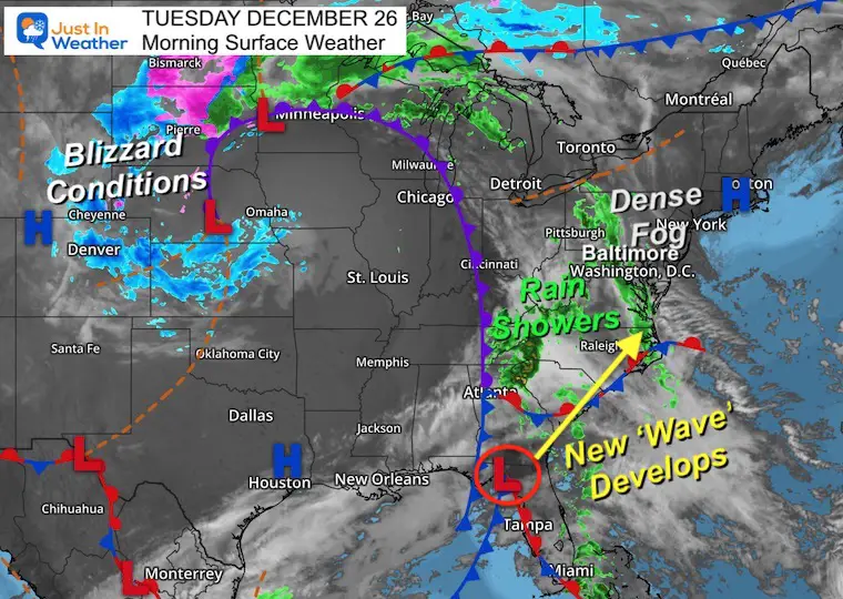
Tuesday Morning Update
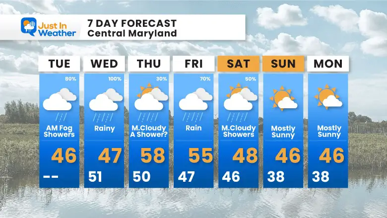
Foggy with drizzle or heavier showers. This is simply a soggy morning, and we may keep that damp feeling around for a few days. A larger storm system to our west has cut off and stalled.
The day with the most rain is likely to be tomorrow, where some places may get one inch, then some showers, and another impulse or two will bring more rain off and on into the start of the weekend.
Cold air will finally return around the New Year. This is not Arctic sourced, but a signal of the change we continue to expect in to January.
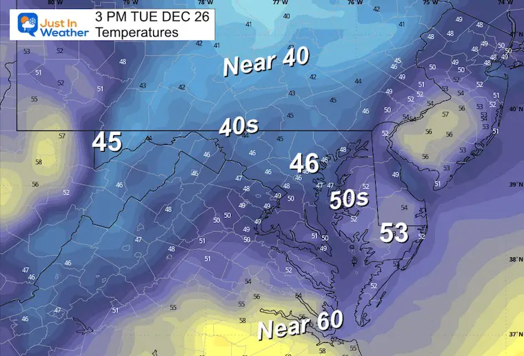
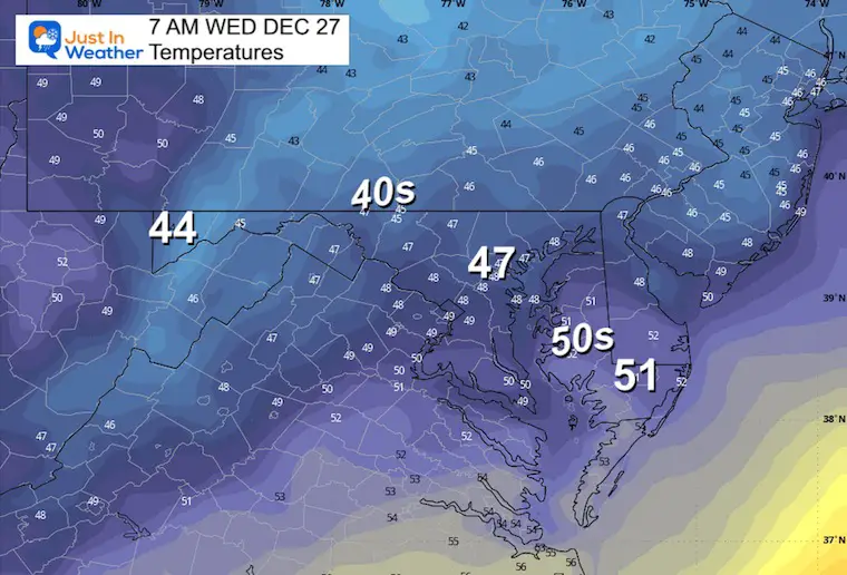
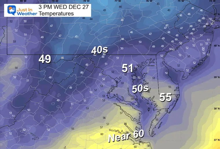
Morning Temperatures
Live Radar Widget
This may be the best tool to use all day, as the forecast simulation has been missing some of the rain. However, there will be pockets of drizzle that may not show up.
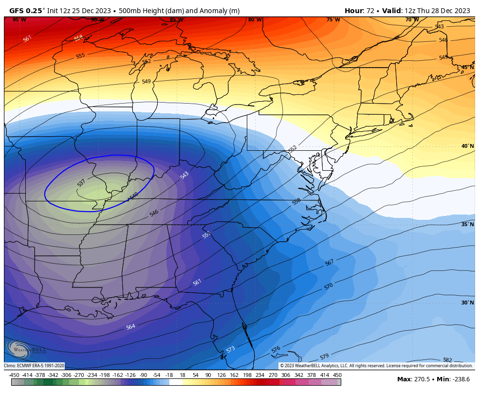
The storm system has occluded. That means it closed off the cold air around the original Low, and the rest of the pattern is sort of stuck. We are on the mild and damp side. That band of rain in the mountains has spread into parts of central Maryland this morning. The fog is thick, and there is a soggy feel today.
A new wave of Low Pressure will develop out of Florida and bring us more rain tomorrow.
The cold air locked up with blizzard conditions across Nebraska and South Dakota will try to make a move east by this weekend.
Sunrise at 7:25 AM
Sunset at 4:50 PM
Normal Low in Baltimore: 28ºF
Record 2ºF in 1983
Normal High in Baltimore: 45ºF
Record 73ºF 1889
Depending on where the heavier rain sets up, there may be spots that get over 1 inch.
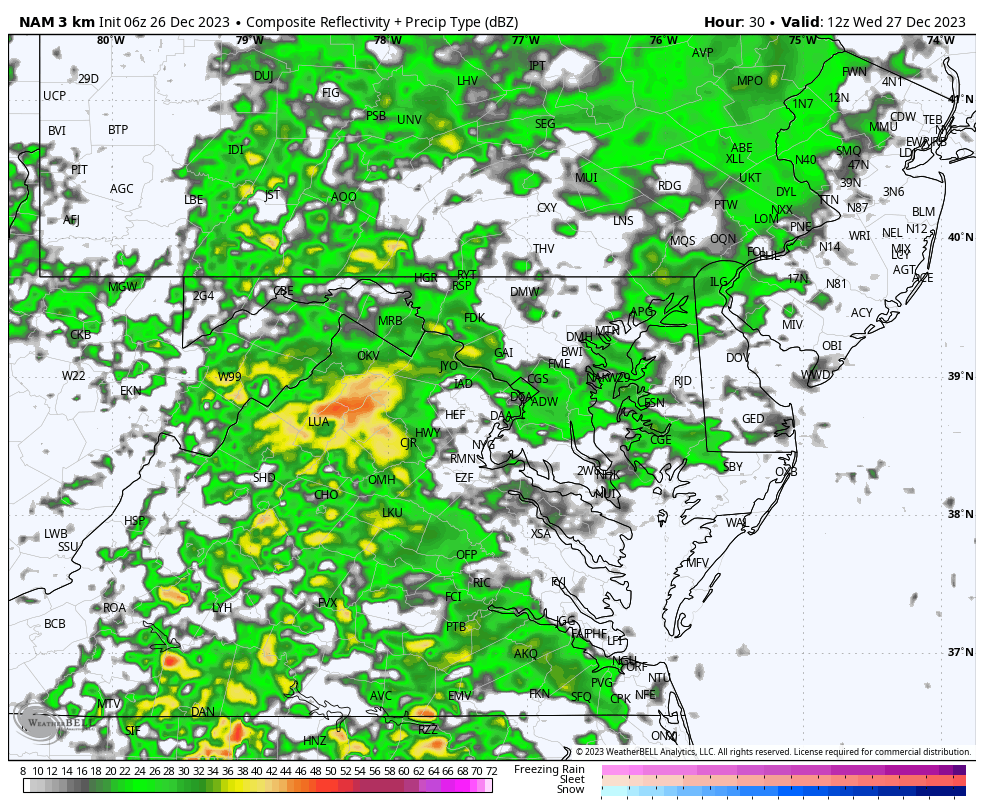
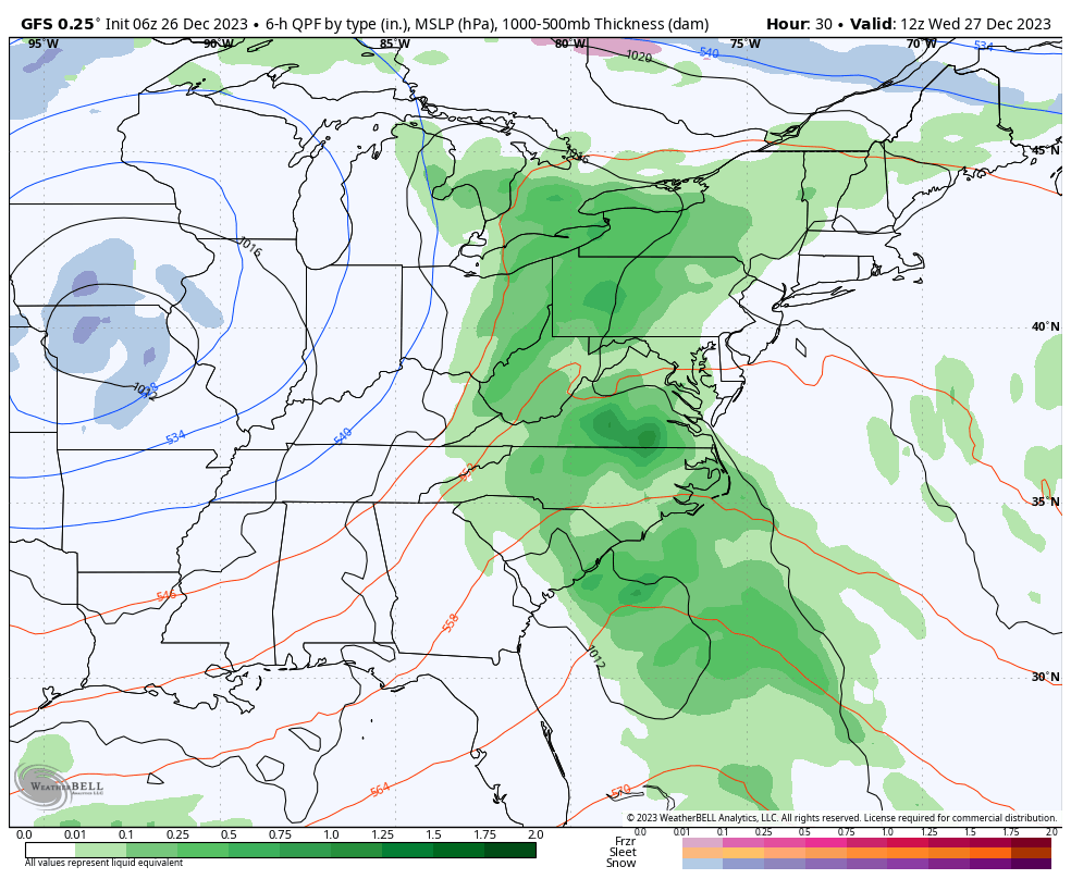
The steadiest and heaviest rain is expected…
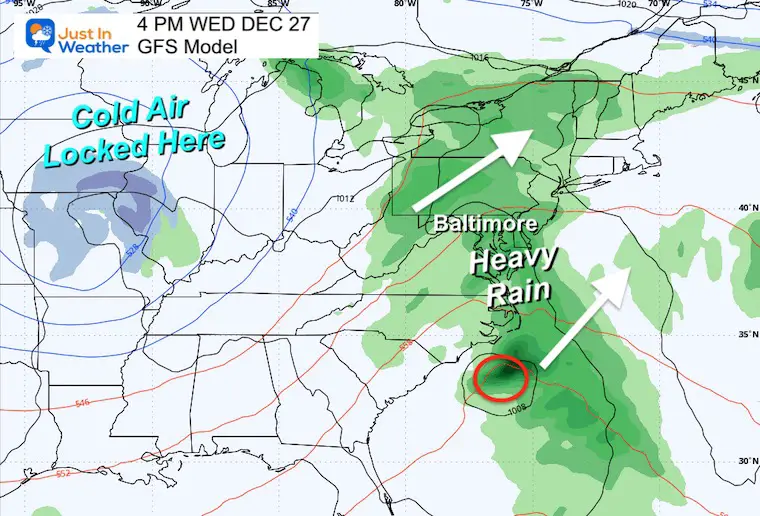
A disturbance behind the storm may extend the rain an additional day. Colder air may develop snow across Northern Pennsylvania.
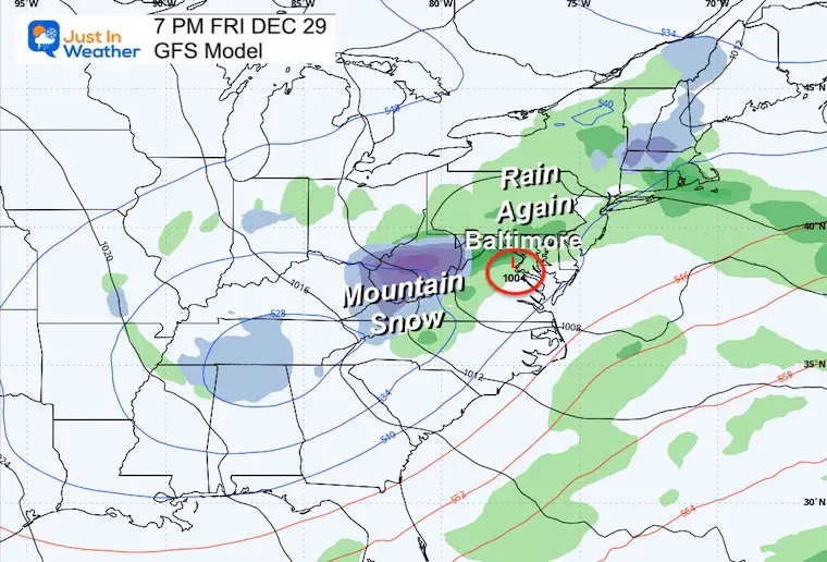
The change is showing up. This is NOT arctic air, but it will be colder with a few more impulses to lock us in for January.
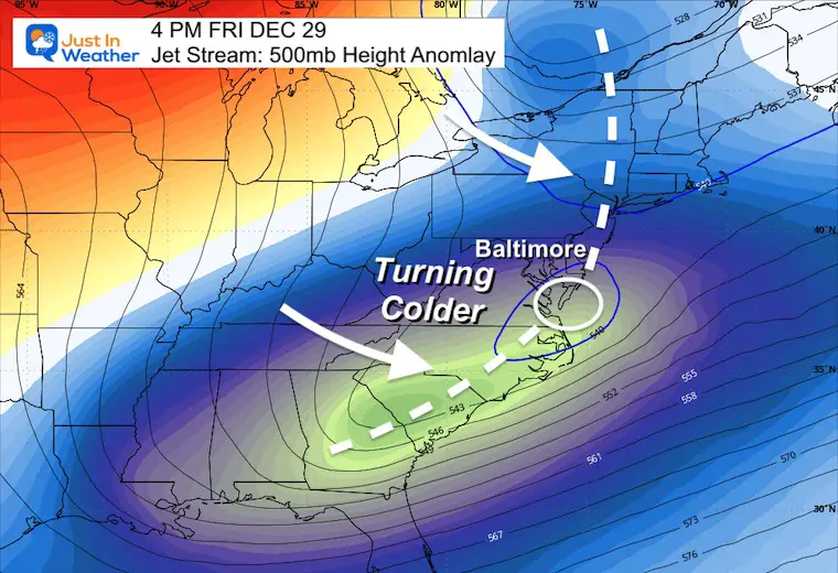
As the storm passes, the shift to colder air will be on Friday afternoon.
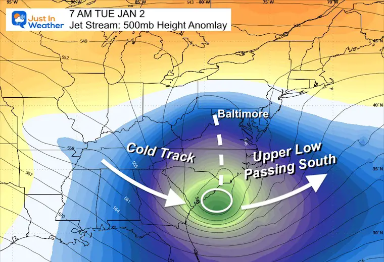
Starting off the New Year, we see an upper-level Low passing to our south. I like the pattern and still see some wiggle room for this to shift north. NOT seeing a weather event now may play to our benefit as the coordination may time out better than seen here 9 days away.
If we can get some form of snow or wintry weather, I would start to look here.
The weather pattern will be stuck for a few days. Showers today, then steadier rain tomorrow will be heavy at times. A few more impulses will keep the risk of rain around until Saturday now. This is a little longer than earlier thought…
The pattern change will begin to show with that last impulse, which will take us to a dry but colder New Year holiday.
Sign up and be the first to know!


Computer Models Support East Coast Storm Track

The latest NOAA report is confident in a Very Strong event. Possibly HISTORIC! This refers to the temperatures in the Pacific, with impacts on the US Winter Storm Track.

Winter Weather Folklore: Top 20 and more signals from nature for snow.
Winter Outlook 2024 From Two Farmers Almanacs Return to Cold and Snow


Click to see more and ‘Book’ a visit to your school

I am aware there are some spelling and grammar typos and occasional other glitches. I take responsibility for my mistakes and even the computer glitches I may miss. I have made a few public statements over the years, but if you are new here, you may have missed it: I have dyslexia and found out during my second year at Cornell University. It didn’t stop me from getting my meteorology degree and being the first to get the AMS CBM in the Baltimore/Washington region. One of my professors told me that I had made it that far without knowing and to not let it be a crutch going forward. That was Mark Wysocki, and he was absolutely correct! I do miss my mistakes in my own proofreading. The autocorrect spell check on my computer sometimes does an injustice to make it worse. I also can make mistakes in forecasting. No one is perfect at predicting the future. All of the maps and information are accurate. The ‘wordy’ stuff can get sticky. There has been no editor who can check my work when I need it and have it ready to send out in a newsworthy timeline. Barbara Werner is a member of the web team that helps me maintain this site. She has taken it upon herself to edit typos when she is available. That could be AFTER you read this. I accept this and perhaps proves what you read is really from me… It’s part of my charm.
#FITF