


May 12 Mothers Day Showers And Another Aurora Viewing Tonight May Be Better
Sunday May 12 Mother's Day Morning Report Today, we focus on the all-important Mother’s Day weather and the ongoing impact of the latest Solar Storm. We have been stuck in…
September 22 Friday Mid-Day Update
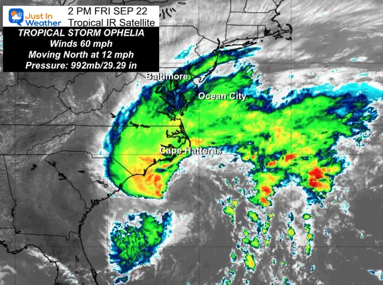
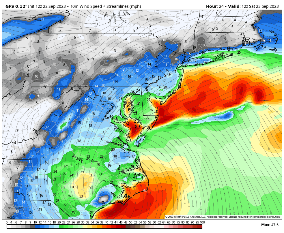
Tropical Storm Ophelia has finally been defined and named by the National Hurricane Center with winds of 60 mph. This makes the warnings valid and for most, it will feel like a Nor’easter with some storm surge, wind damage, isolated tornadoes, and flooding rain.
Many inland areas could get winds between 40 and 50 mph as this has a large footprint (275 miles). The Wind Advisory has been expanded in central Maryland and may still be expanded. With leaves still on the trees, this adds to the chance for tree limbs and power lines to be downed. Another element to consider.
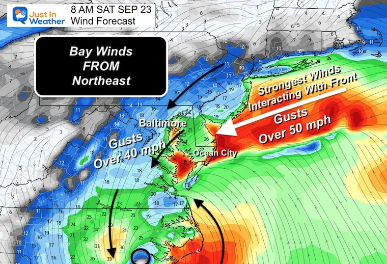
It is important to note the track has shifted to move over Baltimore. This brings the center of Low Pressure WEST of the Chesapeake Bay, which could maximize storm surge. However, this will be weakening quickly AND combatted by winds FROM the Northeast.
Below I have posted the Windy Interactive Widget so you can track the storm timeline.
There are two types of flooding:
Quick Local Notes (See Maps Below)
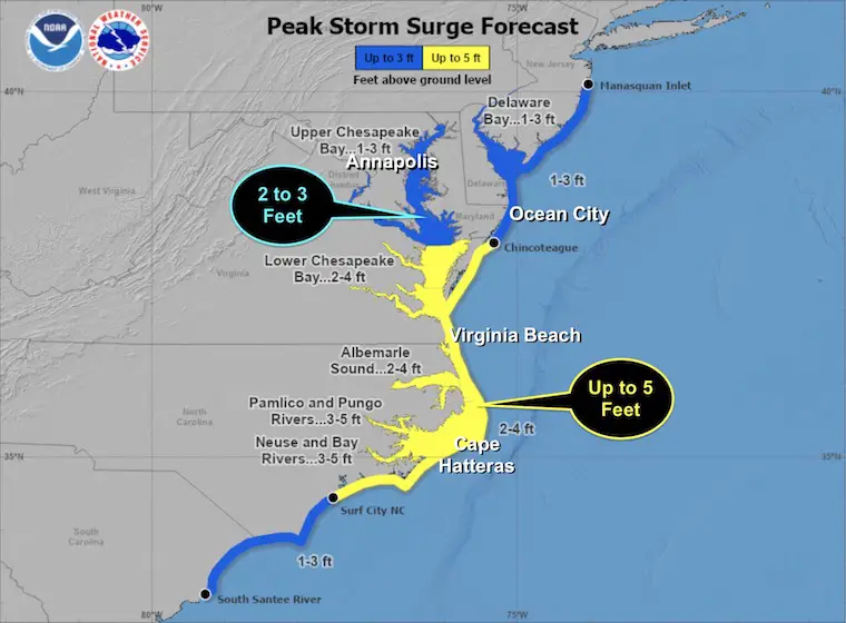
Storm Surge Inundation
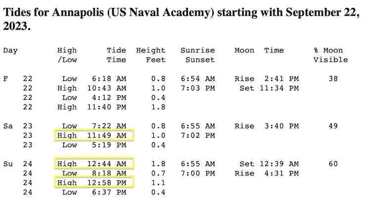
2 to 3 Feet on the Western Shore Of the Chesapeake Bay and Potomac River. Highest at High Tide on Saturday.
The HIGHEST WATER maybe Saturday Evening and overnight!
Rainfall
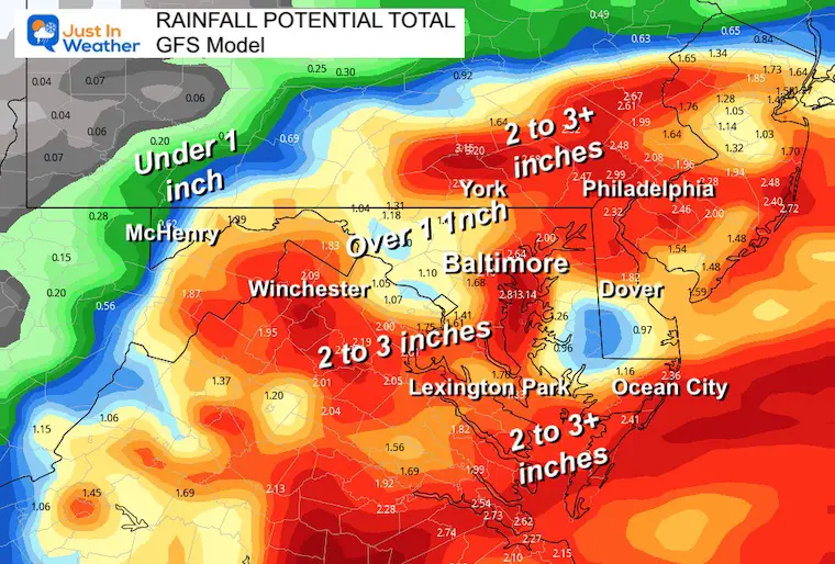
Average 1 to 3 inches. Some spots up to 5 inches.
With the shifted inland track, a broader area of moderate rain will expand to some of the fort ridges of the Appalachian Mountains.
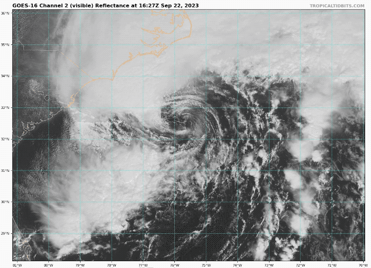
National Hurricane Center Update 2 PM
The central core is more defined. It still has most of the clouds and rainfall to the NORTH SIDE of the Low.
Tropical Storm Force Winds extend 275 miles from the center. It’s big!
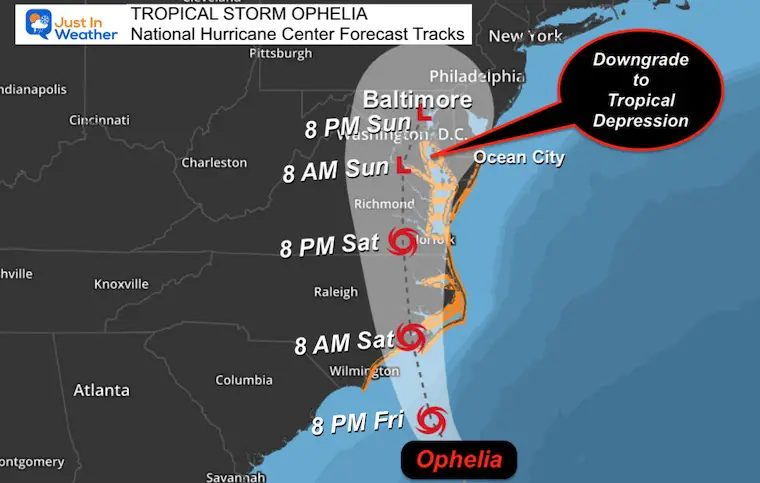
Tropical Storm Ophelia NHC Forecast Map
Forecast Animation
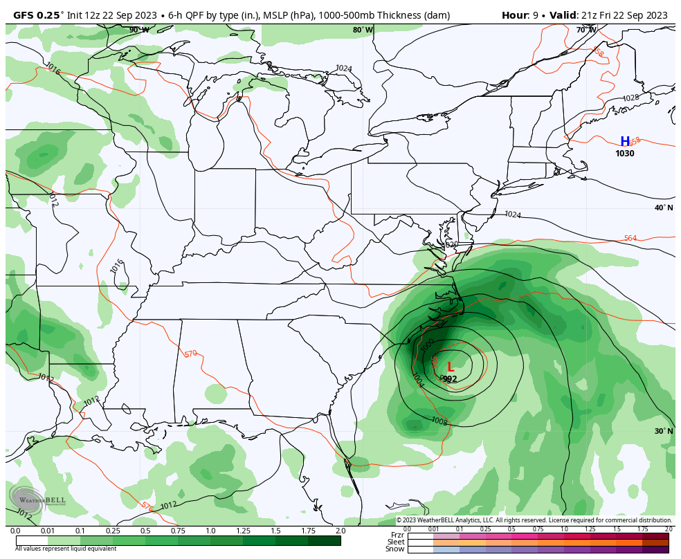
GFS Model 5 PM Friday to 8 AM Monday
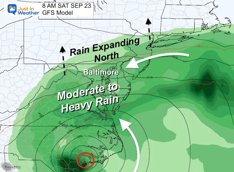
The storm will make landfall in North Carolina by Saturday morning. Then continue to slowly move north. The heaviest rain will be north of the Low.
As this moves into Maryland, it will weaken quickly. What is left when moving off the coast on Monday morning may still produce showers.
SEE A CLOSER LOOK AND KEY TIME FRAMES BELOW.
SUMMARY OF WATCHES AND WARNINGS IN EFFECT:
A Storm Surge Warning is in effect for…
* Beaufort Inlet, North Carolina to Chincoteague, Virginia
* Chesapeake Bay south of Colonial Beach, Virginia
* Neuse and Pamlico Rivers
* Portions of Pamlico and Albemarle Sounds
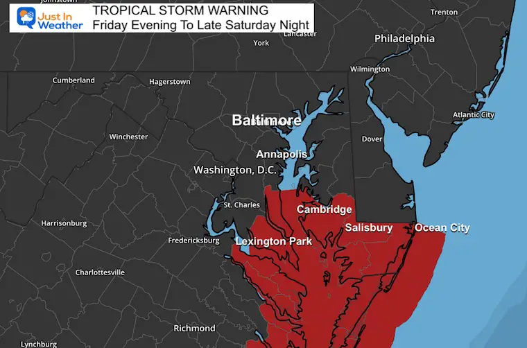
A Tropical Storm Warning is in effect for…
* Cape Fear, North Carolina to Fenwick Island, Delaware
* Albemarle and Pamlico Sounds
* Tidal Potomac south of Cobb Island
* Chesapeake Bay south of North Beach
A Storm Surge Watch is in effect for…
* Surf City, North Carolina to Beaufort Inlet, North Carolina
* Remainder of Pamlico and Albemarle Sounds
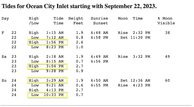
Local High Tide charts are with the local wind forecast maps.
I posted this on Facebook to answer many questions.
Local Warning Maps
Tropical Storm Warning
Maryland: Calvert, St. Mary’s, Dorchester, Wicomico, Somerset, and Worcester.
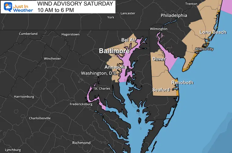
Wind Advisory: Maryland: Anne Arundel PLUS Southeast Baltimore and Harford Counties: Winds up to 50 mph.
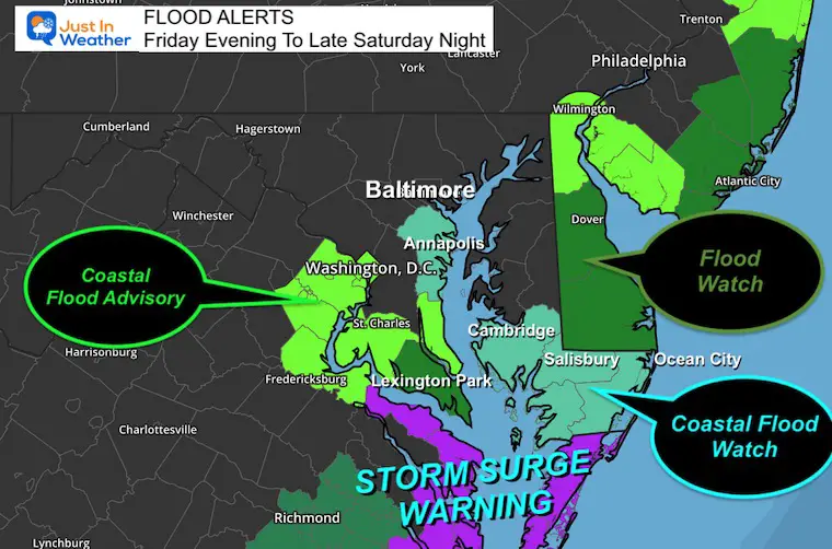
Flood Advisories
Coastal Flood Watch: Potomac River up to Washington, DC.
Storm Surge Warning: Southern Chesapeake Bay and Coastal Areas up to New Jersey.
Gale Warning up to Northern Chesapeake Bay: Waves up to 4 Feet. Wind to 45 knots.
Wind Maps AND Storm Surge On The Chesapeake Bay:
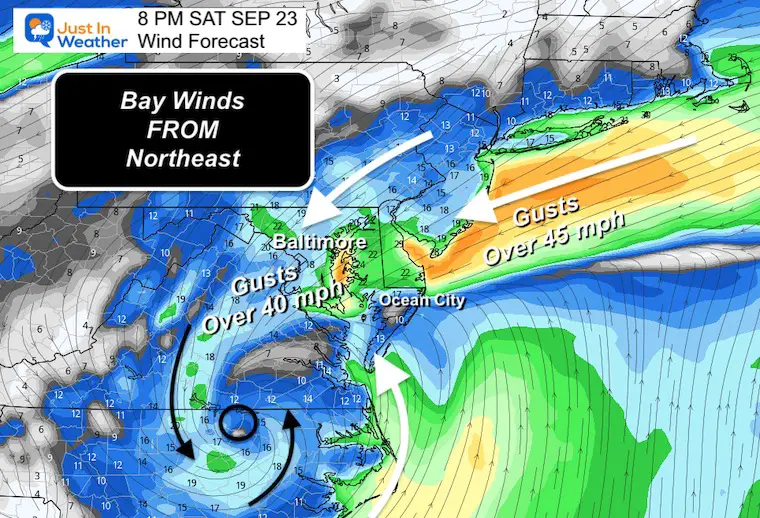
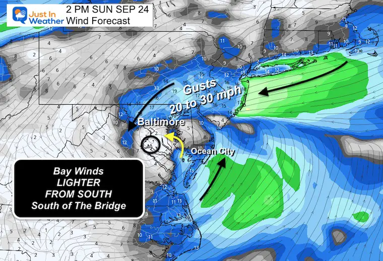
Winds will be FROM the Northeast, while water may rise FROM the Southeast. Not perfectly aligned, but converging ON THE WESTERN SIDE OF THE BAY.
Winds from the Northeast will combat some surge AND help to SLOSH water higher on the WEST SIDE OF THE BAY.
Winds from the Northeast will combat some surge AND help to SLOSH water higher on the WEST SIDE OF THE BAY.
Winds from the Northeast will combat some surge AND help to SLOSH water higher on the WEST SIDE OF THE BAY.
Still gusty, but lighter winds for the Ravens and Commanders football games.
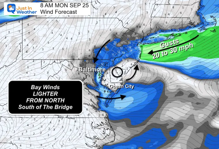
This may be when the wind shifts briefly from the Southeast near the Bay Bridge… Another High Tide worth paying attention to.
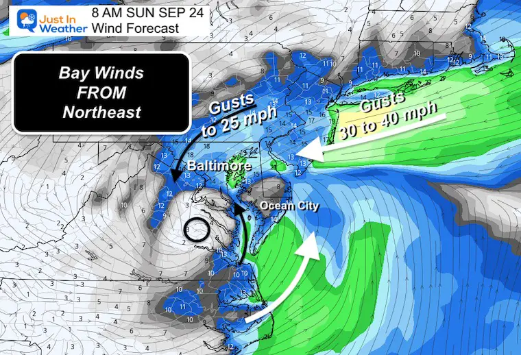
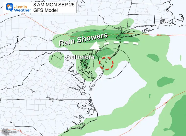
The remnant Low may cross Delmarva after losing most of its punch.
Three Key Points Of Interest. The High Tide Saturday Night is the one where we may see the highest water.
Additional Tables for Maryland can be generated here: Saltwater Tides
Baltimore: Fort McHenry
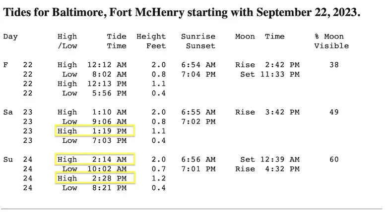
Flooding here is likely all day Saturday
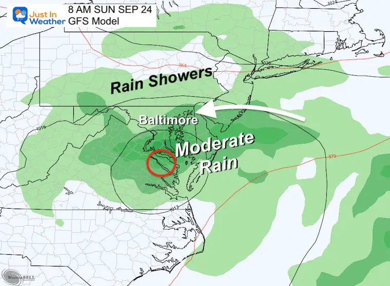
As the storm moves inland, the heaviest rain will be on the NORTH SIDE of the central Low Pressure.
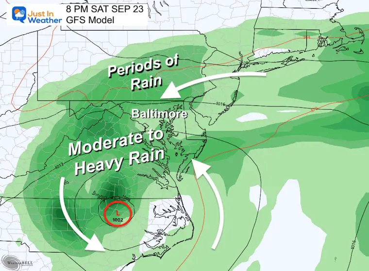
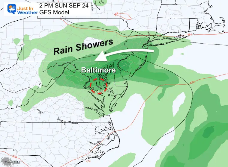
The storm will nearly stall over central Maryland and slowly pivot out off the coast by Monday. It will weaken quickly as it does but showers may stay around.
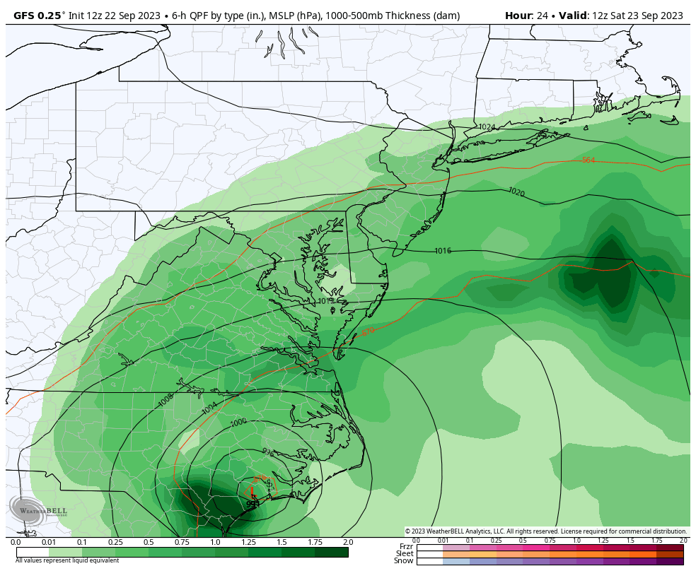
Moderate to Heavy rain will be spreading in early and advancing north into Pennsylvania.
Periods of rain may extend north to State College PA for their football game.
The center of Ophelia will be getting closer, but also getting weaker.
The broad remnant Low Pressure will keep periods of rain with chilly air (60s) for the Ravens (Baltimore) AND Commanders (Landover) games. But the storm will continue to weaken.
The remnant Low will cross Delmarva. Lingering unsettled showers may continue as this moves away.
Rainfall Forecast POTENTIAL
Computer model guidance is a suggestion. This should be seen as a range and not precise expectations.
With the shift west and slow crawl, the moderate rain forecast has expanded west and into Southern Pennsylvania. This is still subject to change based on how rain bands set up.
Additional Note On Airline Travel: Plan for delays with this major storm that is now a Tropical Storm. This storm will have high winds at the surface, and even more turbulence aloft.
I do not know how your flight will be affected. I have seen planes fly on schedule in bad weather, and postponed for minimal impact. It is important to consider not only the weather at your airport, but also where the plane came from and where it is going.
Any delays or rerouting can cascade like dominoes on an already delicate system.

I am aware there are some spelling and grammar typos and occasional other glitches. I take responsibility for my mistakes and even the computer glitches I may miss. I have made a few public statements over the years, but if you are new here, you may have missed it: I have dyslexia and found out during my second year at Cornell University. It didn’t stop me from getting my meteorology degree and being the first to get the AMS CBM in the Baltimore/Washington region. One of my professors told me that I had made it that far without knowing and to not let it be a crutch going forward. That was Mark Wysocki, and he was absolutely correct! I do miss my mistakes in my own proofreading. The autocorrect spell check on my computer sometimes does an injustice to make it worse. I also can make mistakes in forecasting. No one is perfect at predicting the future. All of the maps and information are accurate. The ‘wordy’ stuff can get sticky. There has been no editor who can check my work when I need it and have it ready to send out in a newsworthy timeline. Barbara Werner is a member of the web team that helps me maintain this site. She has taken it upon herself to edit typos when she is available. That could be AFTER you read this. I accept this and perhaps proves what you read is really from me… It’s part of my charm.
#FITF