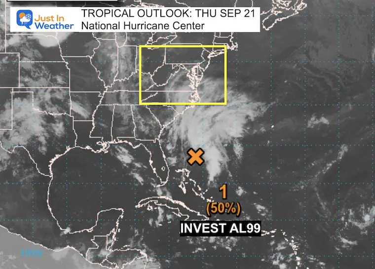
September 21, Thursday Mid-Day Update
The weather system I have been reporting on all week got an upgrade this morning. The National Hurricane Center identified this circulation off the Florida coast as AL99. This ‘invest’ is a trough with a cluster of thunderstorms that has the potential to develop into a tropical or subtropical Low. At this time, the odds have increased to 50% in the next two days. By that point, this system will be moving very close or onshore in the Mid-Atlantic region of the United States.
Tropical Storm Warning And Local Advisories
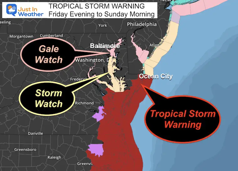
Tropical Storm Warning Statement for Ocean City, MD
– LATEST LOCAL FORECAST: Equivalent Tropical Storm force wind
– Peak Wind Forecast: 30-40 mph with gusts to 55 mph
– Window for Tropical Storm force winds: early Saturday morning until Saturday morning
– THREAT TO LIFE AND PROPERTY THAT INCLUDES TYPICAL FORECAST UNCERTAINTY IN TRACK, SIZE AND INTENSITY: Potential for wind 39 to 57 mph
– PLAN: Plan for hazardous wind of equivalent tropical storm force.
– PREPARE: Efforts to protect property should now be underway. Prepare for limited wind damage.
– ACT: Act now to complete preparations before the wind becomes hazardous.
– POTENTIAL IMPACTS: Limited
– Damage to porches, awnings, carports, sheds, and unanchored mobile homes. Unsecured lightweight objects blown about.
– Many large tree limbs broken off. A few trees snapped or uprooted, especially if soils are saturated. Some roadway signs will sustain damage.
– A few roads will be impassable from debris. Hazardous driving conditions on bridges and other elevated roadways.
– Scattered power and communications outages.
* STORM SURGE
– LATEST LOCAL FORECAST: Localized storm surge possible
– Peak Storm Surge Inundation: The potential for 1-3 feet above ground somewhere within surge-prone areas
– Window of concern: Friday evening until Sunday morning
– THREAT TO LIFE AND PROPERTY THAT INCLUDES TYPICAL FORECAST UNCERTAINTY IN TRACK, SIZE AND INTENSITY: Potential for storm surge flooding greater than 1 foot above ground
– PLAN: Plan for storm surge flooding greater than 1 foot above ground.
– PREPARE: Complete preparations for storm surge flooding, especially in low-lying vulnerable areas, before conditions become unsafe.
– ACT: Leave immediately if evacuation orders are given for your area.
– POTENTIAL IMPACTS: Limited
– Widespread storm surge flooding of vulnerable areas will result in an elevated threat of property damage to homes and businesses near the waterfront and shoreline.
– Sections of low-lying vulnerable roads, parking lots, and property will likely become flooded. Driving conditions could become dangerous in places where flooding covers the road.
– Moderate to severe beach erosion is likely, including heavy surf possibly breaching dunes, especially in vulnerable locations. Strong and dangerous rip currents are likely.
– Minor to moderate damage to marinas, docks, boardwalks, and piers is likely. A few small craft broken away from moorings.
* FLOODING RAIN
– LATEST LOCAL FORECAST:
– Peak Rainfall Amounts: 2-4 inches, with locally higher amounts
– THREAT TO LIFE AND PROPERTY THAT INCLUDES TYPICAL FORECAST UNCERTAINTY IN TRACK, SIZE AND INTENSITY: Potential for moderate flooding rain
– PLAN: Emergency plans should include the potential for moderate flooding from heavy rain. Evacuations and rescues are possible.
– PREPARE: Consider protective actions if you are in an area vulnerable to flooding.
– ACT: Heed any flood watches and warnings. Failure to take action may result in serious injury or loss of life.
– POTENTIAL IMPACTS: Significant
– Flooding from heavy rainfall may prompt evacuations and rescues
– Rivers and tributaries may quickly become swollen, with swift currents, and overspill their banks. Small streams, creeks, and ditches overflow.
– Flood waters can enter some structures and/or weaken foundations. Some areas may experience areas of rapid inundation at underpasses, low-lying spots, and poor drainage areas. Some streets and parking lots take on moving water as storm drains and retention ponds overflow. Driving conditions become hazardous. Some road and bridge closures are expected.
* TORNADO
– LATEST LOCAL FORECAST:
– Situation is unfavorable for tornadoes
– THREAT TO LIFE AND PROPERTY THAT INCLUDES TYPICAL FORECAST UNCERTAINTY IN TRACK, SIZE AND INTENSITY: Tornadoes not expected
– PLAN: Tornadoes are not expected. Showers and thunderstorms with gusty winds may still occur.
– PREPARE: Little to no preparations needed to protect against tornadoes at this time. Keep informed of the latest tornado situation.
– ACT: Listen for changes in the forecast.
– POTENTIAL IMPACTS: Little to None
– Little to no potential impacts from tornadoes.
Local Weather Advisories
As of Thursday mid-day, some may be upgraded as we get closer.
Gale Watch
Friday Evening To Saturday Night
- This includes the Northern Chesapeake Bay.
- Pooles Island to Sandy Point
- Winds 20 to 30 knots, Gusts to 40 knots
- Waves 2 to 4 Feet
Storm Watch
Friday Evening To Saturday Night
- Southern Chesapeake Bay and Coastal Waters
- Winds 25 to 35 knots, Gusts to 50 knots
- Waves Up to 5 Feet.
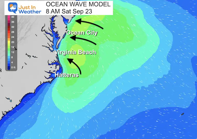
Ocean Wave Model
Saturday Morning
Waves Over 10 Feet likely from Hatteras through Ocean City and coastal New Jersey.
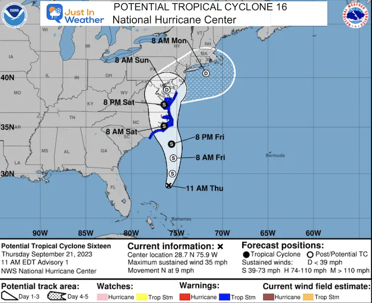
National Hurricane Center Forecast Track
Weather Maps
Even if this is not a named tropical system, it will behave like a very strong Nor’easter all weekend. The hardest impact will be on Saturday.
I will have an update this afternoon and again tonight.
Storm Update
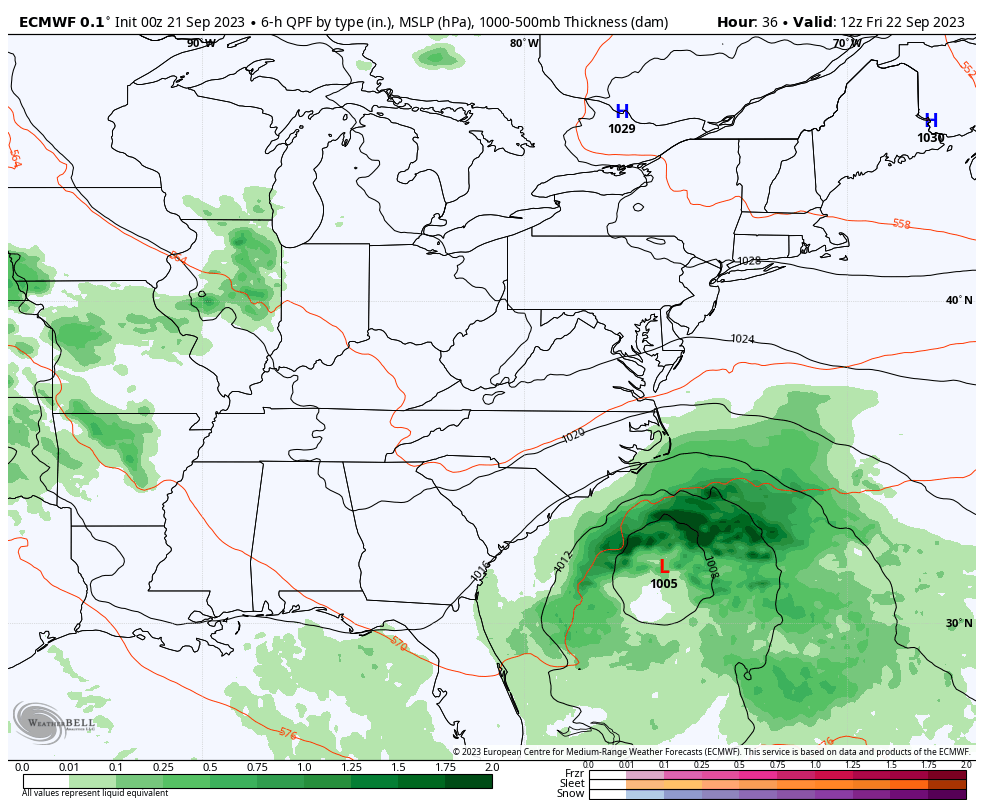
I want to start off with the European ECMWF Model. This was the holdout, trying to bump it off the coast, as I showed in my report last night. Since then, the model has fallen in line with the rest to bring us the storm and keep it around all weekend.
Storm Animation: ECMWF Model Friday Morning to Sunday Night
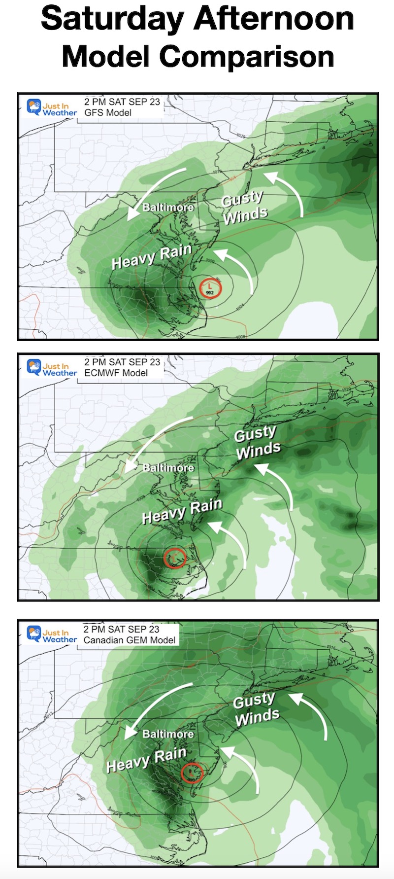
Model Comparison: Saturday Afternoon
This looks like a lot more agreement for a Saturday Soaker. There is still a variation in storm position and track, but negligible to the general rainy expectations. The real difference will be in rain totals.
The net result will be rain and gusty winds, mostly from the Northeast, resulting in a chilly day remaining in the 60s.
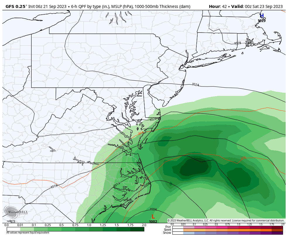
Closer Look: Mid-Atlantic GFS Model
Since this has been the most consistent model, I am relying on it for the overall expectations.
Friday Night to Monday Morning
This covers our weekend and shows three main things:
- The arrival of rain into Southern Maryland will be AFTER DARK on Friday,
- Saturday will be rainy and windy!
- Sunday once again has the storm stalling. The Ravens game looks chilly and wet!
Snapshots
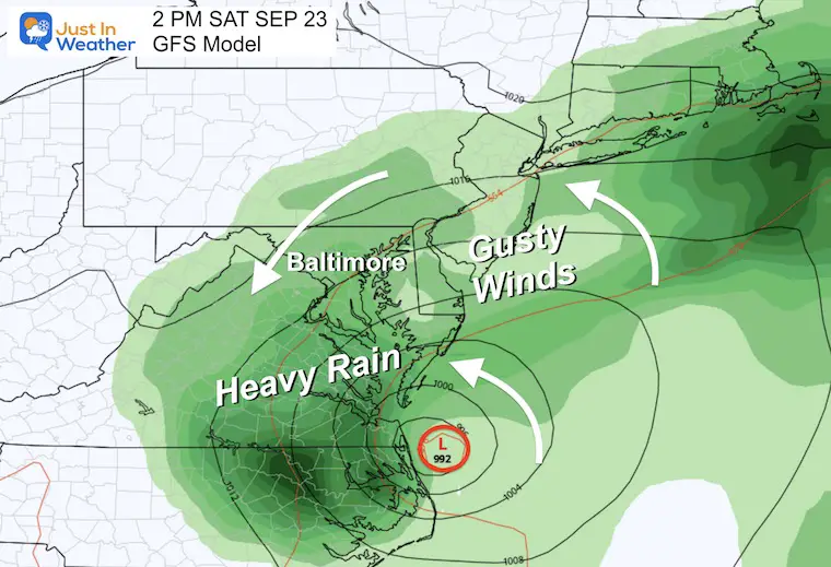
Saturday Afternoon
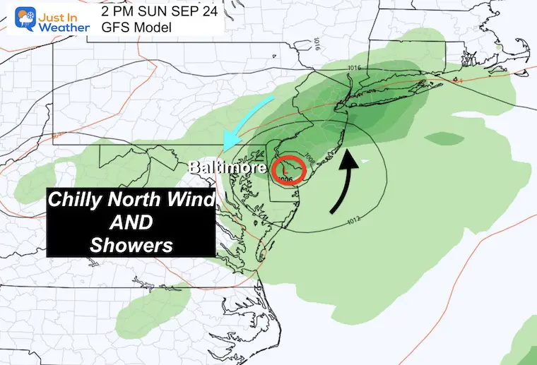
Sunday Afternoon
With the remaining Low Pressure, a chilly north wind and leftover showers are expected for the Ravens game.
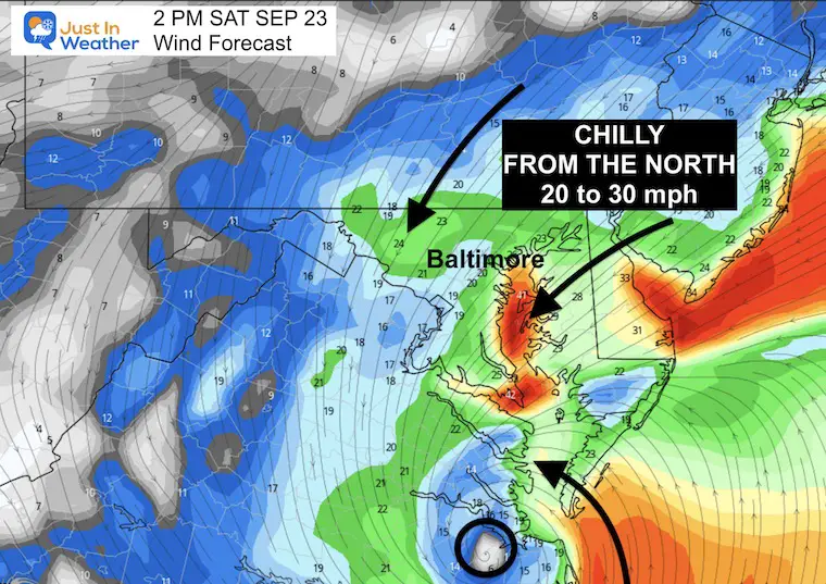
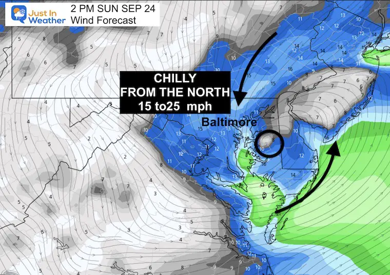
Wind Forecast
Animation: Friday Through Sunday
We can see the slow-moving circulation of the Low Pressure entering central Maryland. The winds FROM THE NORTH on the back side of the storm are what will keep us chilly with the rain.
Snapshot Saturday Afternoon
There may be water piling up on the Western Shore of the Bay, so look out for Coastal Flood Alerts in addition to Flood Advisories from the rain.
Sunday Afternoon
Less windy but chilly from the North.
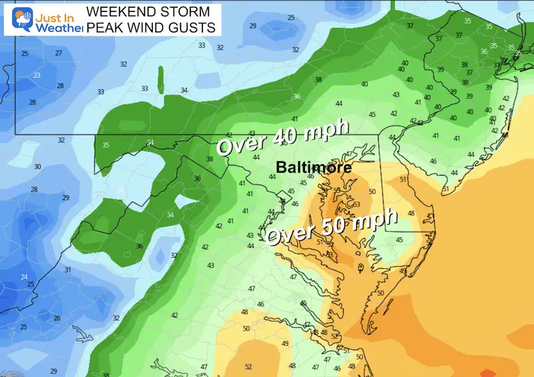
Top Wind Gusts
There will be noticeable winds across the region. Central areas may gust to over 40 mph, with coastal areas possibly reaching over 50 mph.
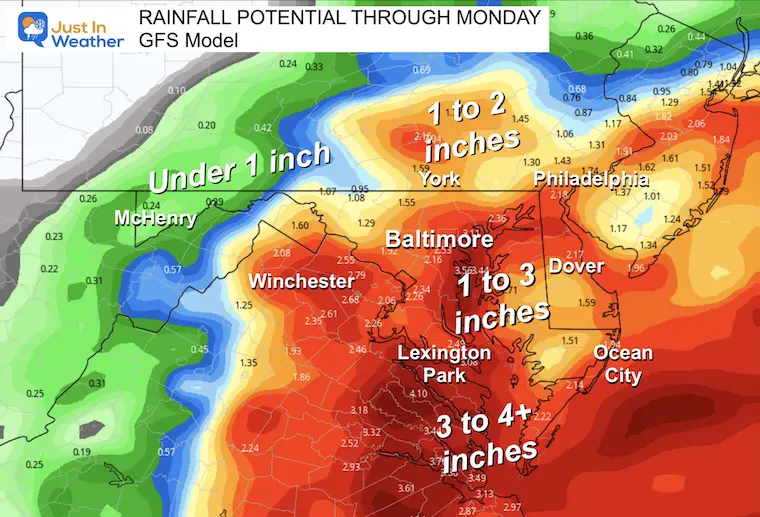
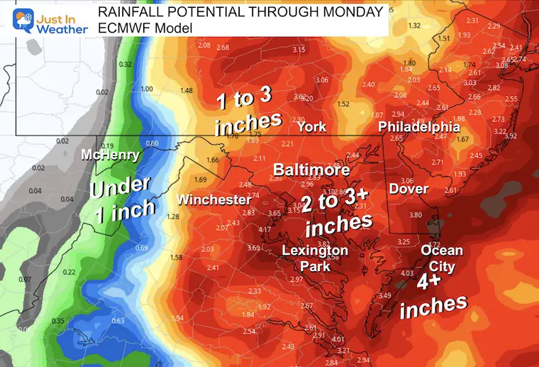
Rainfall Potential
Considering that the European model had shown the storm as a miss, it is now in line with the GFS model to bring a few inches for most areas.
There will be LESS WEST and MORE EAST
GFS Model
European ECMWF Model
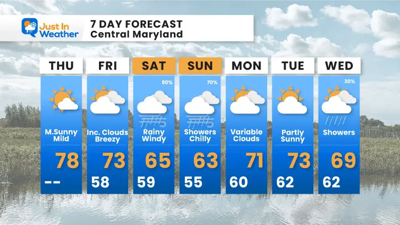
7 Day Forecast
Our Storm Day will be Saturday, but I have to increase our likelihood for it to linger with a chilly day and showers on Sunday. It will be chilly at the Ravens game!
Both afternoons will remain in the 60s. Remember, just last week, we had our record-breaking heat wave! This will be an adjustment.
EARLIER IN AUGUST: Maryland Trek 10 For These Kids
I will have a follow-up and recap on our amazing week shortly.

Subscribe for eMail Alerts

Please share your thoughts and best weather pics/videos, or just keep in touch via social media
RESTATING MY MESSAGE ABOUT DYSLEXIA
I am aware there are some spelling and grammar typos and occasional other glitches. I take responsibility for my mistakes and even the computer glitches I may miss. I have made a few public statements over the years, but if you are new here, you may have missed it: I have dyslexia and found out during my second year at Cornell University. It didn’t stop me from getting my meteorology degree and being the first to get the AMS CBM in the Baltimore/Washington region. One of my professors told me that I had made it that far without knowing and to not let it be a crutch going forward. That was Mark Wysocki, and he was absolutely correct! I do miss my mistakes in my own proofreading. The autocorrect spell check on my computer sometimes does an injustice to make it worse. I also can make mistakes in forecasting. No one is perfect at predicting the future. All of the maps and information are accurate. The ‘wordy’ stuff can get sticky. There has been no editor who can check my work when I need it and have it ready to send out in a newsworthy timeline. Barbara Werner is a member of the web team that helps me maintain this site. She has taken it upon herself to edit typos when she is available. That could be AFTER you read this. I accept this and perhaps proves what you read is really from me… It’s part of my charm.
#FITF


